

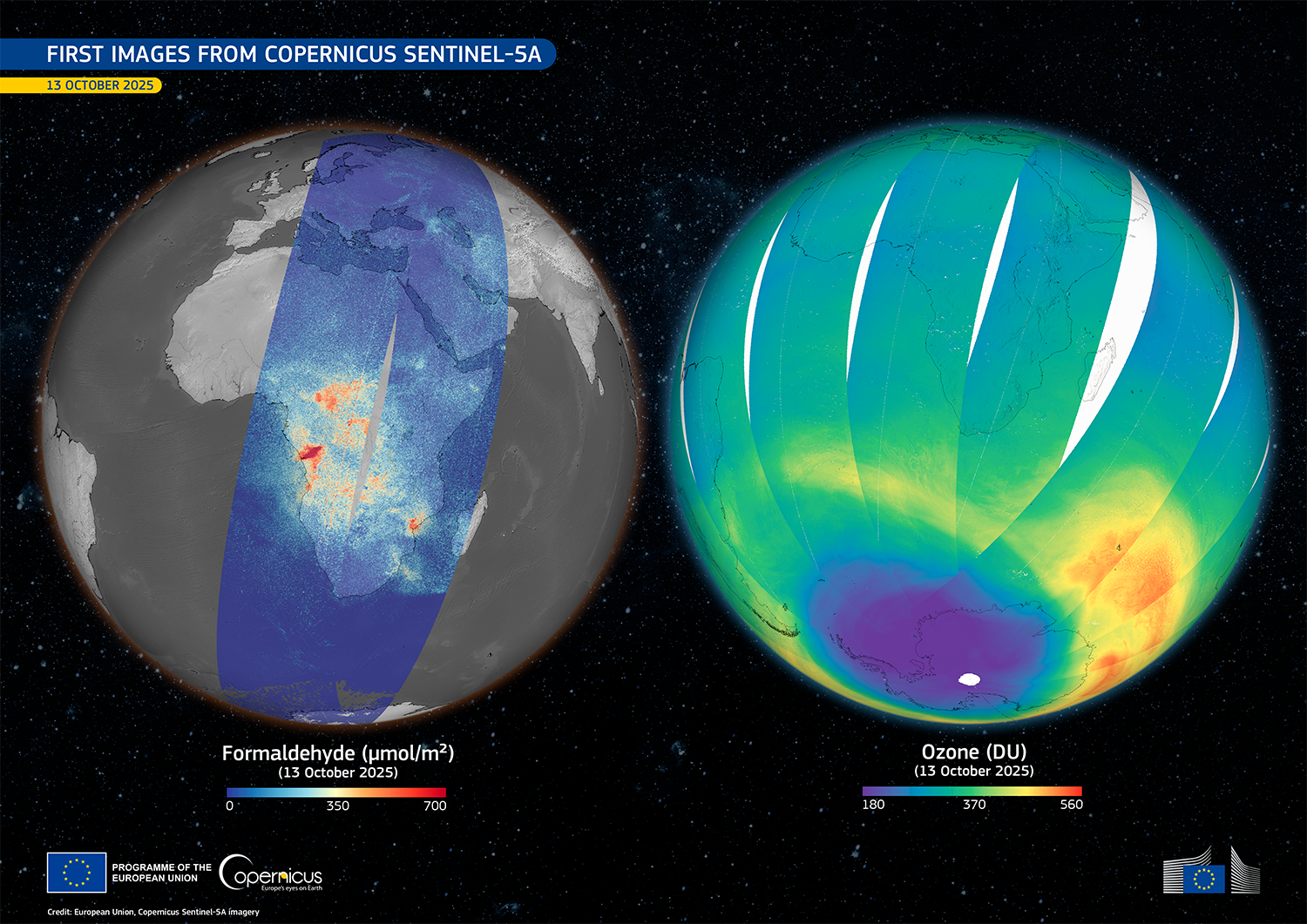
Copernicus Sentinel-1D and Sentinel-5A provide first images, marking important advances in earth and atmospheric monitoring [link]
"Following their successful launches in 2025, two new Copernicus satellite missions, Sentinel-1D and Sentinel-5A, have returned their first images, representing important progress in the EU’s capacity to monitor the planet’s surface and atmosphere."
Related:
Sentinel-1D delivers first images: from Antarctica to Bremen [link]
Sentinel-5 debuts images of atmospheric gases [link]
Level-2 News
ESA Member States commit to largest contributions at Ministerial [link]
Europe has just made its largest-ever commitment to space, with €22.3 billion approved at ESA’s Ministerial Council in Bremen. Member States reinforced Europe’s autonomy and leadership across science, Earth observation, navigation, telecommunications, security, and exploration under ESA’s Strategy 2040. This historic investment strengthens Europe’s resilience from space, advances next-generation Copernicus, and accelerates missions from climate monitoring to planetary defence. At 50 years on, ESA enters its next era with unprecedented political trust, ambition, and scale.
Related:
ESA Keeps the Door Open for More Defense Funding [link]
“ESA plans to keep subscriptions for a new defense initiative open for the next year, instead of following the typical process of finalizing funding at the close of each three-year ministerial meeting.
ESA’s new, record-breaking budget of €22.3B for the next three years includes funding for its proposed European Resilience from Space (ERS) program—a military-grade system of systems, providing surveillance, communications, navigation, and EO capabilities.
The proposal secured €1.2B of the €1.35B sought. The agency now wants to raise at least a further €250M from European defense ministries.”
Sentinel-2 Nighttime Imaging Campaign [link]
"Sentinel-2A is conducting a special acquisition campaign to collect a set of Level-1B nighttime images during the ascending part of its orbit.
The campaign begun on 3 December 2025 and is designed to cover areas of interest related to gas flares, bright lights, wildfires, and fishing/marine activities. This exceptional activity will span one full Sentinel-2A cycle and will target only selected locations. Level-1B data will be acquired in either MSI (Multi-Spectral Instrument) VIC (Vicarious) mode or RAW mode.
ESA’s HydroGNSS mission launched to ‘scout’ for water [link]
"The European Space Agency’s first Scout mission, HydroGNSS, was on 28 November, marking a significant step in advancing global understanding of water availability and the effects of climate change on Earth’s water cycle.
The two twin HydroGNSS satellites were carried into orbit at 19:44 CET aboard a SpaceX Falcon 9 rocket, as part of the Transporter-15 rideshare flight from the Vandenberg Space Force Base in California."
Transporter-15 Brings 140 Payloads to Orbit [link]
"While SpaceX rideshare missions are always chock-full of new tech headed to orbit, Friday’s Transporter-15 flight was busier than most. The launch from Vandenberg Space Force Base in California deployed 140 payloads, which is the second-largest haul since regular Transporter flights began in 2021.
Transporter-15 carried dozens of EO sats intended to kickstart constellations—or build upon tech that’s already in orbit."
Onboard Transporter-15:
High-resolution radar satellites launched for Greece [link]
Italian mission adds to growing IRIDE space fleet [link]
Terramind.tiny flying onboard Planetek Italia's AI-eXpress Plus satellite [link]
ST Engineering to Build SAR Satellite for UAE Program [link]
"Emirati defense and tech company Edge Group has selected ST Engineering to build a synthetic aperture radar (SAR) satellite for the UAE’s national SAR constellation program, Sirb."
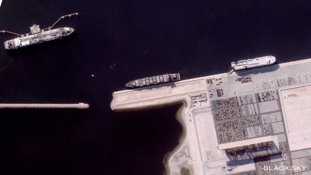
BlackSky Releases First Images from New Gen-3 Satellite After Undisclosed Launch [link]
"BlackSky Technology released images from a recently launched Gen-3 satellite, reporting that it delivered images from the satellite less than 24 hours after launch."
A first for Europe as Infinite Orbits and SES will provide geostationary satellite life extension mission [link]
"Following an in-orbit demonstration, Infinite Orbits will extend the lifespan of at least one of SES’s GEO satellites by five years, with further missions under consideration in the years ahead. This will make Infinite Orbits the first European company to carry out such a mission, and only the second in the world. This collaboration with the world’s biggest GEO satellite operator, Infinite Orbits further strengthens its position as a key partner for GEO in-orbit services."
Enabled Intelligence Bags $708M NGA Contract [link]
"AI startup Enabled Intelligence won an IDIQ contract from the National Geospatial-Intelligence Agency (NGA) worth up to $708.3M to support data labeling activities across the US government. "
ESA and Norway explore possibility of Arctic Space Centre [link]
"The European Space Agency has signed a letter of intent with Norway to advance the prospect of a new ESA Arctic Space Centre to be hosted in Tromsø."
Redwire lands $44 million DARPA award to build air-breathing satellite [link]
"Redwire secured a $44 million contract from the Defense Advanced Research Projects Agency to finish building a satellite designed to operate in very low Earth orbit. The award expands a 2024 agreement in which DARPA tapped the Florida company for its Otter Very Low Earth Orbit mission, an effort to field an air breathing spacecraft that can function in an extremely thin but still resistant atmosphere."
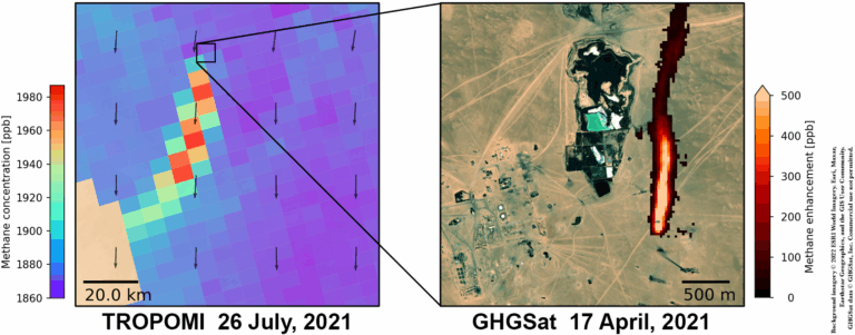
SRON provides new CAMS Service targeting methane emissions at facility level [link]
"The Sentinel satellites, including the TROPOMI instrument, form the backbone of Europe’s Copernicus Earth Observation programme. For the methane emission monitoring within the Copernicus Atmosphere Monitoring Service (CAMS), this data is now complemented by a number of Copernicus Contributing Missions (CCMs) that provide additional information and higher resolution. ESRON will use CCMs to pinpoint individual methane sources all around the world, such as large gas leaks, to provide insights on emissions and initiate mitigation efforts. "
Developer's Orbit
STAC Expands Its Reach [link]
"October 2025 marked two big moments for the SpatioTemporal Asset Catalog (STAC) community: its recognition as an Open Geospatial Consortium (OGC) Community Standard and a community sprint focused on representing multidimensional data with Zarr. Together, they show how STAC is growing into a flexible framework for a wider range of geospatial data.
If you’re working with cloud-native geospatial data, this post explains why this matters."
The Next Phase of Aurora: Open and Collaborative AI for Weather and Climate Forecasting [link]
Microsoft is doubling down on Aurora, its open-source AI model for weather and climate forecasting. Trained on massive atmospheric datasets, Aurora is already showing promise in predicting weather, hurricanes, air quality, and ocean dynamics. By keeping the platform open and expanding research partnerships, Microsoft aims to empower scientists and national meteorological services worldwide to deliver more accurate, locally tailored forecasts where they matter most.
TerraTorch and Iterate have been migrated to a dedicated GitHub organization, TerraStackAI, which will also aggregate other GeoAI projects [link]
STAC Browser v4.0.0-rc.2 is out [link]
"Alongside numerous bug fixes and smaller improvements, this release introduces a long-awaited feature: a new grid system for the card layout.
The first release candidate also delivered several major enhancements, including improved mapping capabilities through OpenLayers, a refreshed header design, and more." [link]
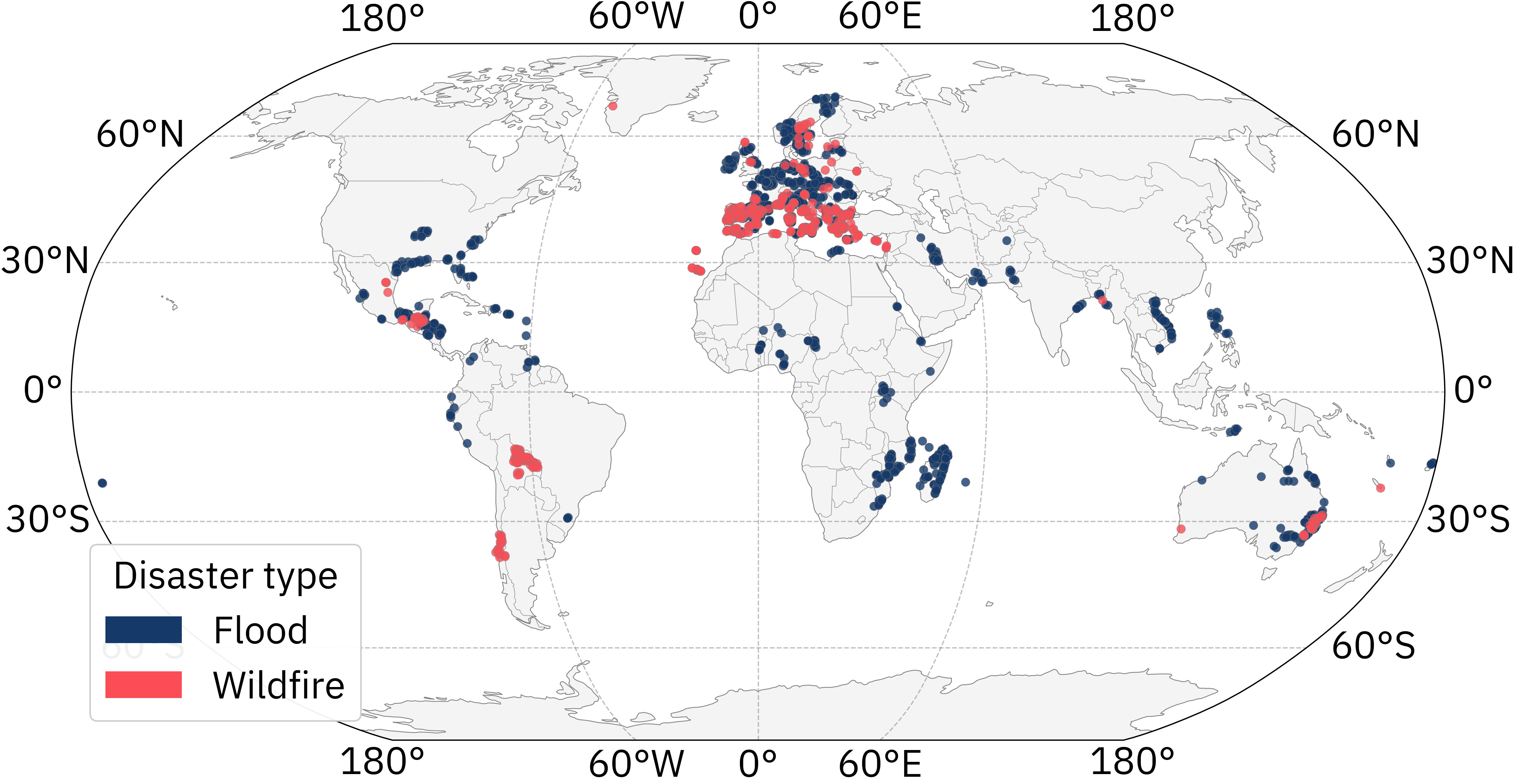
IBM and ESA open-source AI models trained on a new dataset for analyzing extreme floods and wildfires [link]
"IBM and ESA fine-tuned its multi-modal TerraMind models on a first-of-its kind dataset designed to improve how we prepare and respond to natural disasters."
ImpactMesh [link]
"ImpactMesh is a large-scale multimodal, multitemporal dataset for flood and wildfire mapping, released by IBM, DLR, and the ESA Φ-lab. It integrates Sentinel-1 SAR, Sentinel-2 optical, Copernicus DEM, and high-quality annotations from Copernicus EMS. The technical report is released soon."
WeatherNext 2: Our most advanced weather forecasting model [link]
"Google DeepMind and Google Research are introducing WeatherNext 2, their most advanced and efficient forecasting model. WeatherNext 2 can generate forecasts 8x faster and with resolution up to 1-hour. This breakthrough is enabled by a new model that can provide hundreds of possible scenarios.
WeatherNext 2’s forecast data is now available in Earth Engine and BigQuery. They’re also launching an early access program on Google Cloud’s Vertex AI platform for custom model inference."

Snapshots
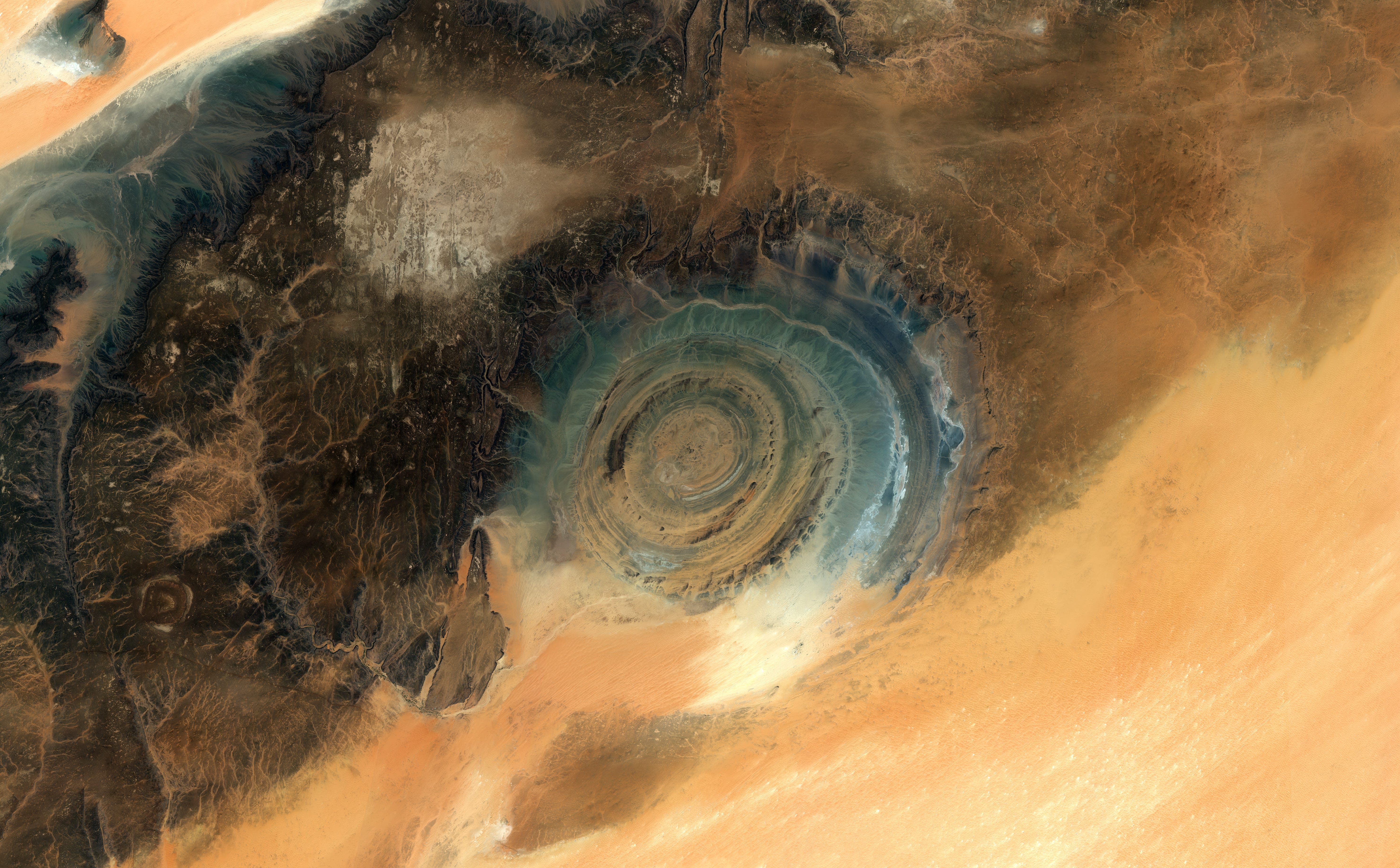
Earth from Space: Eye of the Sahara [link]
"This giant feature looks out from a sea of golden sand in the Adrar Region of northern Mauritania. Once thought to be the site of a meteor impact, the Richat Structure is now believed to have been caused by a process of uplift of a large dome of molten rock that, once at the surface, was shaped by wind, sand and water erosion. Geologists agree that the structure is at least 100 million years old.
The layered formation consists of a series of concentric rings and resembles a bull’s eye from space, so is also known as the eye of the Sahara or the eye of Africa."
Interesting read

EarthCARE lifts the clouds on climate models [link]
"True to its promise, the European Space Agency’s EarthCARE satellite is now being used to calculate directly how clouds and aerosols influence Earth’s energy balance – the all-important balance that regulates our climate. In doing so, EarthCARE is poised to sharpen the accuracy of climate models, the very tools that guide global climate policy and action."
Related:
Exploring EarthCARE Data and Analysis Tools [link]
"To fully exploit the wealth of EarthCARE data, ESA and its partners have developed a comprehensive suite of data access, visualisation, analysis, and simulation tools. These tools not only support scientific discovery and validation, but also ensure that the mission’s data are readily usable by the broader research community.
From visualisation (Timeline Viewer, Imagery Portal), to analysis (MAAP, DIVA, ectools, earthcarekit), to simulation (ATLID, MSI and CPR simulators), the toolchain supports the full EarthCARE lifecycle from quicklooks to algorithm development and validation.
ESA provides two online platforms on which several tools are hosted. The platforms are EarthCARE MAAP (Multi-mission Algorithm and Analysis Platform) and DIVA (Demonstration of an Integrated approach for the Validation and exploitation of Atmospheric missions)."
The Cloud's Final Frontier: Orbital Data Centers and the Future of Earth Observation

On a hot August afternoon in the early 2040s, a wildfire flares in a parched valley in the Mediterranean. A single satellite snaps a frame; just one tile in the endless strip of data silently collecting in low-Earth orbit.
LinkedIn Highlights

What makes TiTiler so valuable [link]
ESA’s InCubed is strengthening Europe’s global leadership in Earth Observation
[link]
Europe’s EO sector is thriving at €2.66B in revenue, but growth depends on turning innovation into customers. ESA’s InCubed is doing exactly that: unlocking over €350M in private funding, accelerating scale-up, and strengthening Europe’s global leadership in Earth Observation.
I no longer feel happy about new satellite launches. There are too many. Except ESA. All their satellites have a specific purpose.
This morning I listened to a Canada Space Agency webinar on how much money Canada just gave to ESA (it seems like they were a little shocked!) and how that will "proportionally" open up opportunities for Canadian companies with ESA.