

Level-2 News
Sentinel-6B launched to extend record of sea-level rise [link]
"The Copernicus Sentinel-6B satellite is now circling Earth, ready to continue a decades-long mission to track the height of the planet’s seas – a key measure of climate change.
Like its predecessor, Sentinel-6 Michael Freilich, Sentinel-6B carries the latest radar altimetry technology to further extend the sea-surface height record that began in the early 1990s. These measurements help scientists understand sea-level rise – crucial information for shaping climate policy and protecting the millions of people living in coastal areas around the world."
Canada announces massive jump in funding to European Space Agency [link]
"Canada, seeking tighter ties with the European Union, will boost its investment in European Space Agency programs by C$528.5 million ($377.96 million), a tenfold increase compared to previous contributions, a top cabinet member said on Tuesday.
Canadian Prime Minister Mark Carney, who won an April election on the back of a promise to diversify the economy in the face of U.S. tariffs, is pressing for tighter defense and security relations with the EU."
Satellogic Reports Third Quarter Financial Results [link]
Satellogic reported strong momentum in Q3 2025, with revenue rising 29% to $3.6M while operating costs fell 18%. The company also strengthened its balance sheet through a $90M public offering and announced a seven-figure strategic data distribution deal with Suhora covering India and Nepal. In parallel, Satellogic unveiled its new 30 cm-class NextGen satellite platform with onboard AI processing.
ESA Business Incubation Centres: Celebrating 2000 Start-ups Empowered Across Europe [link]
"The European Space Agency proudly celebrates a major milestone in its mission to nurture innovation and entrepreneurship as over 2000 European start-ups have now been successfully incubated through the ESA Business Incubation Centres (BICs) network. With 37 centres across 23 countries, the ESA BICs form Europe’s largest ecosystem dedicated to supporting space-related ventures."
GHGSat Orders 2 Satellites from SFL Missions for Methane-Monitoring Constellation [link]
"Montreal-based GHGSat has ordered two additional satellites from SFL Missions for its greenhouse gas monitoring constellation. The two companies have been longtime partners, with SFL Missions building 11 satellites for GHGSat over the past decade.
These satellites will be GHGSat-C18 and -C19. They will be built on SFL’s high-performance 15 kg NEMO satellite platform. GHGSat ordered two satellites from SFL last year as well."
Earth Fire Alliance and OroraTech Partner to Expand Global Access to Space-Based Wildfire Intelligence [link]
"Earth Fire Alliance (EFA) and OroraTech announced a new partnership aimed at transforming access to wildfire data for responders worldwide.
By combining data and efforts, EFA and OroraTech will empower agencies across the globe with real-time wildfire detection, monitoring, and mitigation insights. This partnership advances the organizations’ common missions by launching initial services as soon as possible with a focus on non-governmental organization (NGO)-led fire management efforts in regions such as Kruger National Park in South Africa and conservation areas across the African continent."
Redwire Wins $44M DARPA Contract for VLEO Demo [link]
"Redwire Corporation ($RDW) landed a $44M Phase 2 contract from DARPA, which tasks Redwire to manufacture and deliver a VLEO satellite with air breathing electric propulsion (ABEP) technology.
The contract is part of DARPA’s Otter program, which aims to validate the tech in VLEO through a flight lasting more than a year at an orbital altitude between 90 and 250 km."
Carbon Mapper has helped the state of California mitigate methane emissions events [link]
"The California Air Resources Board shared that the Tanager-1 satellite and data from Carbon Mapper has helped the state identify and mitigate 10 large methane emissions events at oil and gas facilities since May."
Developer’s Orbit
Coherent Change Detection on phidown 0.1.22 [link]
This tutorial uses a pair of Sentinel-1 SLC images over the area affected by the Port of Beirut explosion on August 4, 2020, at 5:00 p.m. CEST, to demonstrate coherence-based change detection for mapping surface changes.
Colab Notebook [link]
phidown Notebook [link]
Integration of AIS data into phidown [link]
"This notebook walks through pulling Sentinel-1 SAR scenes and matching AIS reports for the same area and time window."
GDAL 3.12.0 “Chicoutimi” is released [link]
"It is a large user-facing release that continues the remaking of the GDAL command line. Follow this link or a full listing of features, bug fixes, and changes."
TerraTorch team celebrated its 1000 issues/pull requests anniversary [link]
TerraTorch reaching 1000 issues and pull requests indicates steady project maturity and active community engagement.
TerraTorch is a PyTorch domain library based on PyTorch Lightning and the TorchGeo domain library for geospatial data. [link]

Data
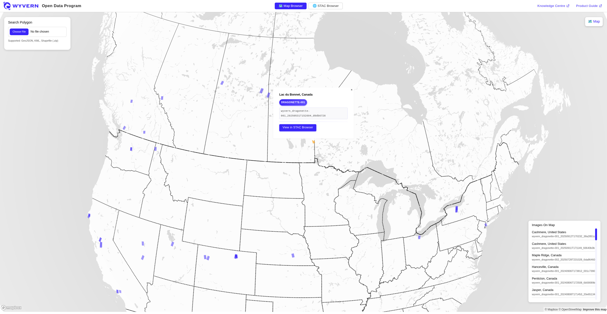
Wyvern’s open data program is now browsable via map [link]
Wyvern launched their Open Data Program back in February 2025 and has been updating a open knowledge centre for working with Wyvern hyperspectral imagery. [link]
Making their catalog browsable via map is a nice touch!
 seem with the new EMC-BUILT data set. White areas are more than 300m from the nearest building detected.")
Datasets added to the gee-community-catalog [link]
Copernicus EMC-BUILT Global Built-up Surface R2025A
OpenBuildingMap Global Building Footprints with Semantic Information
Global Renewables Watch Temporal Dataset of Solar and Wind Energy
Biodiversity Intactness Index (BII) for sub-Saharan Africa
Related:
EMC-BUILT R2025A – Exposure Mapping Component built-up surface grid, derived from Sentinel-2 year 2022 [link]
GFM now includes data from Sentinel-1C [link]
The Global Flood Monitoring (GFM) product of the Copernicus Emergency Management Service (CEMS) is now including data from Sentinel1C.
Snapshots
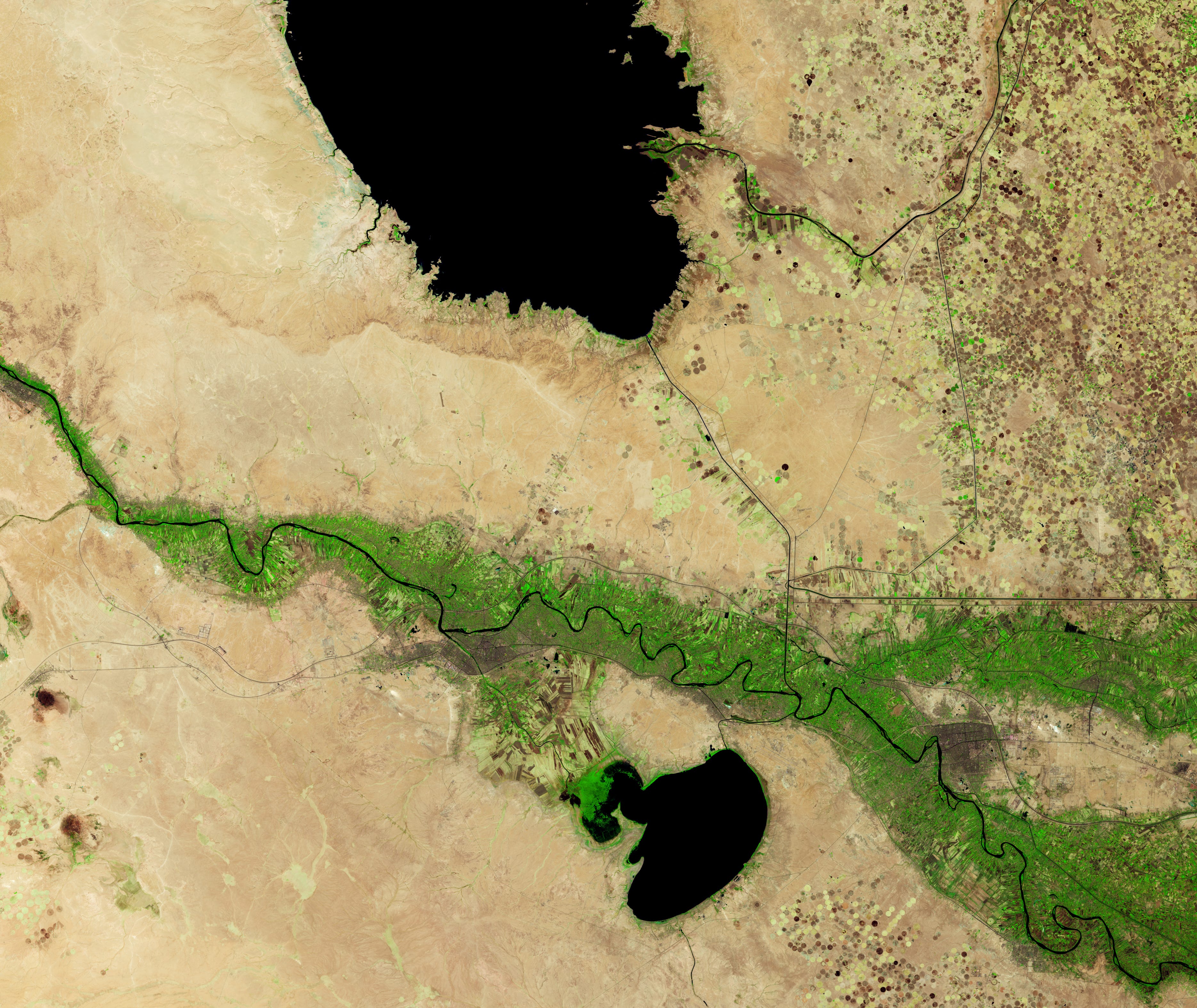
Iraq Reservoirs Plunge to Low Levels [link]
"Satellite observations of Lake Tharthar show that the reservoir’s water levels have swung sharply during the past three decades.
The lake, Iraq’s largest, lies within a broad natural depression between the Tigris and Euphrates rivers, although its water comes only from the Tigris. During periods of excess flow, water managers divert floodwater from the river at the Samarra barrage via a canal and into the reservoir. These inflows usually cause water levels to spike in the spring, when snowmelt in the headwaters of the Tigris in Türkiye and Iran joins with runoff from seasonal rains.
However, a lack of snow and rain, along with upstream diversions, have starved the reservoir of inflow in recent years, preventing water levels from rising in 2021, 2022, and 2023. Despite a slight improvement in 2024, plunging water levels have accompanied the multi-year drought."
Interesting reads
The Cloud Native Geospatial Conference — Now in One NotebookLM [link]
A NotebookLM resource covering the Cloud Native Geospatial (CNG) conference
After the ~60 talks from the Cloud Native Geospatial (CNG) conference in Utah were released, Simon Ilyushchenko, Google Earth Engine Data Ingestion Lead, used Gemini Deep Research to synthesise them into a cohesive narrative summary. He then spent significant time refining and editing the output into a high-quality NotebookLM resource, now accompanied by a podcast version. A great way to catch up on the full conference in one structured pass.
Cloud Native Geospatial 2025: Systems, Lakehouse, and Generative AI [link]
Global Nature Watch Turns Data into Environmental Intelligence [link]
Global Nature Watch is a new AI-powered, open monitoring platform that turns more than 80 peer-reviewed environmental datasets into accessible planetary intelligence. Built with Land & Carbon Lab, it lets anyone ask plain-language questions about forests, grasslands, wetlands, agriculture, and carbon — and get authoritative maps and insights in seconds. Powered by GeoAgents and cloud-native geospatial infrastructure, it bridges rigorous science with real-world decision-making for communities, policymakers, and businesses worldwide.
Common Practices for Quantifying Methane Emissions from Plumes Detected by Remote Sensing [link]
This document establishes community-accepted best practices for quantifying methane emissions from spectroscopic remote sensing of individual plumes. Developed by domain experts, it promotes consistency in how methane estimates are generated, validated, reported, and quality-controlled across different sensors and methodologies. Aimed at both data producers and users, it provides essential guidance for ensuring that emission products are reliable, transparent, and fit for purpose.
Climate

A Free Slide Deck on Climate Change [link]
"Climate Central created Climate Change: Key Facts, a free slide deck available in English and Spanish, using their library of Climate Matters content — all of which is reviewed by staff scientists in line with our high standards for accuracy and clarity.
The 72-slide presentation features Climate Central’s clear and compelling graphics. Speaker notes on each slide explain the science and include links to learn more and customize the presentation with local graphics for 240+ U.S. cities."
ESA investigates high-stakes Amazon tipping point [link]
"For decades, the Amazon rainforest has quietly absorbed vast quantities of human-generated carbon dioxide, helping to slow the pace of climate change. Recent evidence, however, suggests that this vital natural buffer may be weakening – though uncertainties remain.
To help close this critical knowledge gap, European and Brazilian researchers have gathered deep in the Amazon to carry out an ambitious European Space Agency-funded field campaign."
Podcasts
Join Matt Forrest, Chris, and Isaac as they cut through the noise of geospatial AI to explore whether foundation models are truly ready for deployment, or if the field is still navigating a “wild wild west” of unproven tools and hype.
This discussion challenges the industry’s obsession with foundation models, arguing that “scale is a trap” and that solving fundamental data infrastructure bottlenecks often creates more value than complex deep learning.
Ultimately, the conversation suggests that the best way to cut through the noise is to simply “go touch some data” and focus on solving specific, real-world problems with grounded methods.
LinkedIn Highlights

QGIS vs. ArcGIS in Google Trends [link]
A quick look at QGIS vs. ArcGIS popularity using Google Trends, via Matt Forest.
“A super cool use case for Skysat videos from orbit: Measuring river flow rates from space” [link]
Maps, Models and Systems in Spatial Understanding [link]
Building on Fei-Fei Li’s “Spatial Intelligence,” Aravind frames geospatial understanding in three layers: maps, models, and systems. While EO has mastered maps and is moving into models, true value is shifting toward systems that drive decisions.
Call For Papers
Call for Papers: ITU Kaleidoscope 2026 [link]
"Kaleidoscope 2026, hosted by the AI for Good Global Summit 2026, invites multidisciplinary, original research proposals that explore how frontier technologies, including artificial intelligence, brain–computer interface, embodied AI, autonomous driving, geospatial and quantum information technologies interface with telecommunications."
Submission of full paper proposals: 15 December 2025
Learning
Can we generate a credible SAR image from an optical image? [link]
Elise Colin dives into the physics, philosophy, and hard limits of SAR simulation, unpacking what generative models can (and can’t) truly reproduce. If you work with radar, generative AI, or remote sensing realism, this is a must-read.
Thanks for featuring the podcast Akis! I should note I also have my own podcast where we talk about similar subjects also, with my co-host Krishna Karra.
Added a whole bunch new links to my booky.io !
Lots of interesting news here.