

LPS25 Copernicus Student Grants [link]
"The European Commission offers grants to students enrolled in higher education institutes and programmes in the European Union who are interested in attending the Living Planet Symposium 2025, which will be held in Vienna, Austria, on 23–27 June.
If you are an MSc, PhD or Postdoc student enrolled at a higher education institute, such as a university or college etc., in an EU member state or a participating state to the EU Copernicus programme, you are eligible for a LPS25 student grant."
"First Light" Images

Constellr releases first-light imagery of Tokyo [link]
"German startup Constellr released first-light imagery, on March 17, from Skybee-1, the initial satellite in its thermal-imaging constellation.
With Skybee-1 data, Constellr created a detailed map of the heat distribution for Tokyo’s buildings, parks and waterways."

Pixxel’s Firefly Satellites Capture High-Resolution Hyperspectral Images [link]
"Pixxel’s three Firefly hyperspectral satellites have successfully captured and downlinked their ‘first light’ images, the company announced on March 18."
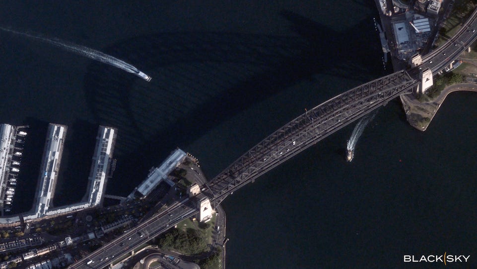
BlackSky Shares First Images from New Gen-3 Satellite [link]
"BlackSky Technology shared the first images from the company’s first Gen-3 satellite which launched on Feb. 18.
BlackSky shared two very high-resolution images on Tuesday, one collected over the Sydney International Airport and the other over the Sydney Harbor Bridge in Australia. The company said these images were collected just five days after the launch."
Level-2 News
OroraTech is launching a constellation of eight satellites next week [link]
"OroraTech Constellation Phase 1 will be riding aboard Rocket Lab’s Electron rocket from their Launch Complex 1 in New Zealand. The satellites are currently there receiving final integration testing, for launch on Wednesday evening (Central European Time)."
Mission Name: "Finding Hot Wildfires Near You" [link]
OroraTech announced a partnership with Google's AI Collaborative: Wildfires initiative [link]
"OroraTech announced their partnership with Google on their AI Collaborative: Wildfires team initiative to address the wildfire crisis. The partnership represents a focus for organizations across the world on wildfire, unifying our efforts into a common goal to reduce the economic, social, and environmental toll of catastrophic wildfires.
The AI Collaborative: Wildfires is a strategic initiative catalyzed by Google.org that brings together leading nonprofits, academic institutions, government agencies, and companies around the joint goal of harnessing AI’s potential to transform the world’s relationship with fire. "
Wyvern and NUVIEW announced a strategic partnership [link]
"Wyvern and NUVIEW announced a strategic collaboration that brings Wyvern’s high-resolution hyperspectral satellite imagery to NUVIEW’s LiDAR suite and Earth observation marketplace."
Planet Labs Uses Anthropic’s Claude AI Model for Geospatial Satellite Imagery [link]
"Planet Labs will work with Anthropic to utilize the company’s large language model Claude for analyzing Earth observation data, Planet announced on March 6. "
Esper Satellites Raises $3.1M Seed Round [link]
"Esper Satellites, which is building hyperspectral imaging sats to detect mineral deposits on Earth, closed a $5M AUD ($3.1M) seed round to expand its operations on the ground and in orbit."
Rocket Lab launches Japanese SAR satellite [link]
"Rocket Lab launched a synthetic aperture radar (SAR) imaging satellite for a Japanese company March 14, the first of eight such missions Rocket Lab has under contract with that customer."
Spire Global and Nvidia Collaborate on AI Weather Models [link]
"Spire Global introduced two AI weather models: AI-WX and AI-S2S, developed on the Nvidia Omniverse Blueprint for Earth-2 platform, Spire announced on March 18."
Developer's Orbit
New Model Release: Prithvi EO 2.0 – Burn Scars [link]
"The pretrained Prithvi-EO-2.0-300M model is fine-tuned to segment the extent of burned areas on HLS images from the HLS Burn Scars dataset."
Prithvi-EO-2.0 BurnScars Demo [link]
Colab notebook example [link]
LinkedIn Post [link]
Satellogic's Open Satellite Feed [link]
Follow this post by Mark Litwintschik, as he examines Satellogic's constellation and their open data feed - 10 TB of satellite imagery on S3 from 127 countries around the world.
Related: Wyvern's Open Satellite Feed [link]
"Wyvern launched an open data programme for their VNIR, 23 to 31-band hyperspectral satellite imagery.
In this post, Mark Litwintschik examines Wyvern's open data feed."
Font-GIS [link]
Icon font and SVG for use with GIS and spatial analysis tools
Upwelling phenomenon in North-West Africa - Africa continent [link]
"Daria, Scientific Engineer at NOVELTIS, shares codes to explore the upwelling phenomena in North-West Africa. This practical exercice was updated in 2025 and presented during the EU Ocean Data Webinar: Ocean-driven solutions for a sustainable economy and resilient communities."
Data
Level-2 data boost EarthCARE's profiling power [link]
"EarthCARE’s Level-2 data products are now fully available, offering users more precise and detailed atmospheric profiling data.
Launched on 28 May 2024, ESA’s Earth Cloud, Aerosol, and Radiation Explorer (EarthCARE) mission is the largest and most complex Earth Explorer to date. With its four instruments — a Cloud Profiling Radar (CPR), an Atmospheric UV Lidar (ATLID), a Broadband Radiometer (BBR), and a Multispectral Imager (MSI) — EarthCARE makes a variety of measurements that, when taken together, provide unique insights into the complex interactions between clouds, aerosols and radiation.
Two types of products have been released: Level-2a single-sensor products derived from individual instruments on EarthCARE; and Level-2b combined products derived from two EarthCARE instruments. By combining measurements from instruments like radar and lidar, for example, the Level-2b products offer greater accuracy and detail than single-instrument outputs. This release features combined products from CPR & ATLID, ATLID & MSI, and MSI & BBR, with additional combinations planned for the future." [link]
Seabed 2030: Open Access Global bathymetry data [link]
"The Nippon Foundation and GEBCO formed Seabed 2030 as an ambitious call to action for humanity to mobilise and accelerate efforts to produce a definitive map of our ocean by 2030 and make it available to all.
You can download some of the GEBCO Gridded Data in netCDF, Esri ASCII raster and data GeoTiff formats. GEBCO releases a new global grid every year generally in June." [link]
NOAA Global Forecast System (GFS) netCDF Formatted Data [link]
"NOAA's widely used Global Forecast System (GFS) data is now available in hourly netCDF format on AWS." [link]

A visual catalog browser for the GEE community catalog [link]
"A seamless way to explore datasets with powerful features like:
Thematic & Keyword Filtering : Find exactly what you need
Smart Search : Includes session-based search history
Grid & List Views : Browse the way that suits you
Sort & Randomize : Organize datasets effortlessly
One-Click Access : Jump to docs & example code in Earth Engine"
For more, check out Samapriya Roy's post on LinkedIn.
Find Landsat and Sentinel-2 Imagery by Area of Interest in Worldview [link]
"A new NASA Worldview tutorial shows you how to find NASA Harmonized Landsat and Sentinel-2 (HLS) project data imagery by area-of-interest." [link]

Snapshots
Earth from Space: Halong Bay, Vietnam [link]
"This Copernicus Sentinel-2 image showcases striking rocky formations amid the blue waters of Halong Bay in northeast Vietnam."
Interesting reads
NASA Analysis Shows Unexpected Amount of Sea Level Rise in 2024 [link]
"Global sea level rose faster than expected in 2024, mostly because of ocean water expanding as it warms, or thermal expansion. According to a NASA-led analysis, last year’s rate of rise was 0.23 inches (0.59 centimeters) per year, compared to the expected rate of 0.17 inches (0.43 centimeters) per year."
Next-Generation Water Satellite Maps Seafloor From Space [link]
"There are better maps of the Moon’s surface than of the bottom of Earth’s ocean. Researchers have been working for decades to change that. As part of the ongoing effort, a NASA-supported team recently published one of the most detailed maps yet of the ocean floor, using data from the SWOT (Surface Water and Ocean Topography) satellite, a collaboration between NASA and the French space agency CNES (Centre National d’Études Spatiales)."
LinkedIn Highlights
"Cool Maps Get You Noticed. Boring Maps Get You Paid." [link]
Check Mina Nada's take on the difference between maps that impress and maps that get results (and contracts).
Upcoming Events
A New Framework for Data Processing [link]
"The European Space Agency - ESA is introducing the Earth Observation Processing Framework (EOPF) Zarr format, a cloud-ready solution built for seamless interoperability.
This session will provide a comprehensive overview of the EOPF Sentinel Zarr Samples, highlighting their capabilities and applications.
Through a live tutorial using Jupyter notebooks, you'll gain hands-on insights into working with this new format."
27 March at 11 AM CET
Copernicus Marine Essentials [link]
"The Copernicus Marine Service is hosting a 3-part webinar series for beginners, designed to engage marine communities worldwide. This series is perfect for first-time users looking to explore, access, and use ocean data with confidence. By the end, you'll have a clear understanding of all available Copernicus Marine resources and how to apply them to your work."
Sessions: 1st, 15th and 29th of April 2025
Open Roles
Performance Senior Scientist for ESA TRUTHS Mission at the National Physical Laboratory (Teddington, UK) [link]
Research Sciences Resident (AI for Good) Intern at the AI for Good Research Lab (Nairobi, Kenya) [link]
Several AI/ML Open Roles at Sust Global (US/UK) [link]
Learning
ARSET - Fundamentals of Remote Sensing [link]
"In this self-paced course, you’ll learn the underlying science behind how remote sensing works and the basic functional characteristics of satellites and sensors. You will explore the kinds of satellite remote sensing data that are available, advantages and disadvantages of remote sensing, and some basic tools to visualize data.
By the end of the course, you’ll be equipped to begin your journey using NASA’s no-cost, open-access remote sensing data and resources.
Earn a certificate upon successful completion of the course."

Tutorial series on the GeoAI Python package, by Qiusheng Wu [link]
This proliferation of satellites....how is there funding for them all? How can they possibly be adding enough value in comparison to what is already there?