NASA’s AI Earth Copilot will take your questions about our planet [link]
"NASA is teaming up with Microsoft to create an AI chatbot designed to make it easier to access and understand scientific data about the Earth. The tool, called Earth Copilot, will be able to answer questions about our planet by condensing NASA’s wide swath of geospatial information into easy-to-digest responses.
To create the tool, NASA is integrating AI into its data repository, allowing Earth Copilot to refer to this information when answering questions, such as “What was the impact of Hurricane Ian in Sanibel Island?” or “How did the COVID-19 pandemic affect air quality in the US?”"
Related:
From questions to discoveries: NASA’s new Earth Copilot brings Microsoft AI capabilities to democratize access to complex data [link]
Level-2 News
Sentinel-1C fuelled ahead of liftoff [link]
"Marking a major milestone in the preparation of Copernicus Sentinel-1C for its scheduled 3 December liftoff, experts have completed the critical and hazardous process of fuelling the satellite.
Once in orbit, Sentinel-1C will extend the Sentinel-1 mission’s legacy, delivering radar imagery to monitor Earth’s changing environment to support a diverse range of applications and scientific research. Additionally, Sentinel-1C brings new capabilities for detecting and monitoring maritime traffic"
ESA signs contracts advancing Greece’s Earth observation capabilities [link]
"The European Space Agency signed six contracts that will help position Greece as a key player in the field of Earth observation."
MethaneSAT released new high-resolution images of methane emission [link]
"Newly released images showcase MethaneSAT's groundbreaking ability to produce high precision, high resolution quantitative data on methane emissions over wide areas from the oil and gas sector. This includes total emissions coming from smaller, dispersed sources that are largely invisible to other satellites operating today.
The new images include the Appalachian, Permian and Uinta basins in the US; the Amu Darya and South Caspian basins in Turkmenistan; and the Maturin basin in Venezuela."
Spire Sells Ship-Tracking Business In $241M Deal [link]
"EO company Spire announced a transformative deal on Wednesday to sell its maritime business line to Kpler, a Belgian trade intelligence firm, eliminating mounting debt and putting the firm on a stronger financial footing."
Developer's Orbit
PMTiles: Geospatial file format for planet-scale raster or vector tiles without a server [link]
"PMTiles is a single-file archive format for tiled data. A PMTiles archive can be hosted on a commodity storage platform such as S3, and enables low-cost, zero-maintenance map applications that are "serverless" - free of a custom tile backend or third party provider."
Repo on GitHub [link]
One week of ocean tides animated across Australasia [link]
As part of the #30DayMapChallenge, Robbi Bishop-Taylor, a Coastal Earth Observation Scientist at Geoscience Australia, created this animation (for Day 11 "Time and space").
Mapped using the EOT20 tide model and code from the experimental 'eo-tides' Python package.
Deep Learning Model Boosts Accuracy in Long-Range Weather and Climate Forecasting [link]
"Dale Durran, a professor in the Atmospheric Sciences Department at the University of Washington, introduces a breakthrough deep learning model that combines atmospheric and oceanic data to set new climate and weather prediction accuracy standards.
In this NVIDIA GTC 2024 session, Durran presents techniques that reduce reliance on traditional parameterizations, enabling the model to bypass many approximations common in weather prediction. A HEALPix grid—a mesh borrowed from astronomy—enhances spatial precision by accurately representing Earth’s spherical shape, eliminating distortions for more precise global forecasts."
Follow the link to watch the full session "Sub-Seasonal and Seasonal Forecasting with a Deep Learning Earth-System Model" [link]

Snapshots

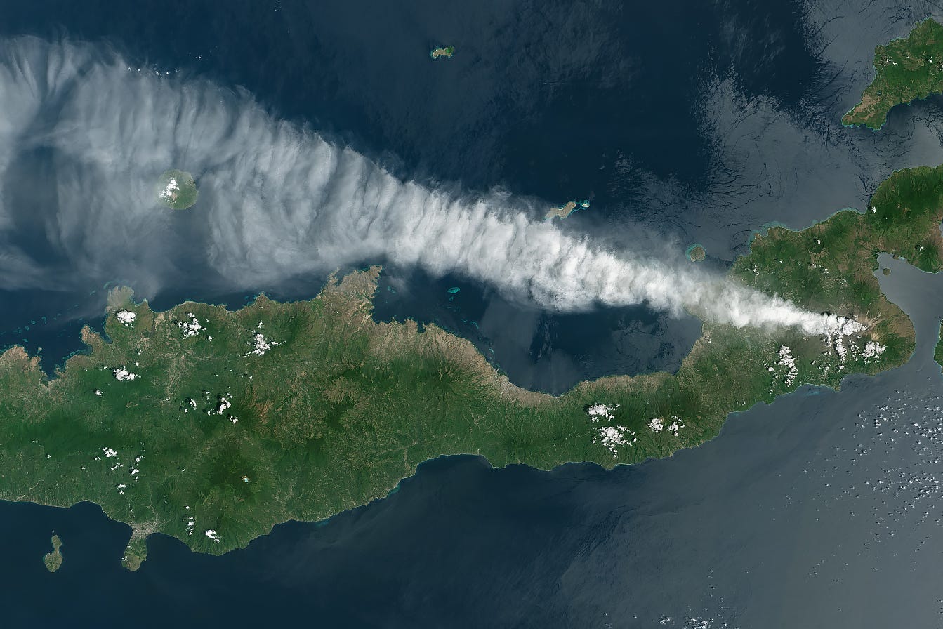
Indonesia Continues to Erupt [link]
"Following nearly two decades of quiet, Mount Lewotobi Laki-Laki—a volcano on the Indonesian island of Flores—began erupting again in December 2023. An especially intense period of activity in November 2024 included several explosive eruptions that generated deadly pyroclastic flows, darkened the landscape with ashfall, and lofted soaring ash plumes that disrupted air travel."
Climate
How close are we to reaching a global warming of 1.5˚C? [link]
"Reaching 1.5°C of global warming above pre-industrial levels - a limit agreed under the Paris agreement - may feel like a very distant reality, but it might be closer than you think. Experts suggest it is likely to happen between the late 2020s and the early 2050s. See where we are now and how soon we would reach the limit if the warming continued at today’s pace."
Explore the C3S global temperature trend monitor [link]
Related:
We’ve ‘lost’ 19 years in the battle against global warming since the Paris Agreement [link]
Interesting reads

How oil and gas companies disguise their methane emissions [link]
"FT analysis shows that firms regularly hide leakages of the deadly greenhouse gas — despite this being one of the easiest climate fixes there is."
Missions like NASA's EMIT (installed on the International Space Station) and the Tanager-1 satellite help detect and measure emissions.
Geospatial AI for Land Use, by The Alan Turing Institute [link]
"The Geospatial Commission commissioned the Alan Turing Institute in 2022 to explore how land use decision making can be supported by geospatial data, including earth observation data, and artificial intelligence. This independent report sets out their findings."
Key Highlights:
The impact of low-resolution satellite data
Standalone satellite image embeddings extracted from low-resolution satellite imagery have remarkable predictive capability
Combining traditional urban predictors with satellite image embeddings enhances model performance
The integration of geographical context, such as regional latitude and longitude, improves model performance
Low or medium resolution satellite imagery can be leveraged to predict outcomes that are not directly visible within the images
Large Language Models (LLMs) in Land Use Decision-Making
Applications: LLMs can support scenario generation, data summarization, and interactive exploration of model outputs, lowering barriers for non-technical users like policymakers.
Challenges: Issues include inaccuracies in LLM outputs, biases in scenario interpretation, and the complexity of incorporating geographic context.
Cross-cutting challenges and opportunities for geo AI
Strategic challenges
Reliance on proprietary foundational models creates dependency on external providers, limiting transparency and control.
Open foundational geospatial models tailored to specific national needs could mitigate these risks.
Operational Challenges
High computational and licensing costs for training and deploying geospatial AI models hinder adoption.
Centralized infrastructure and licensing solutions are needed to support resource-constrained organizations.
Technical knowledge and skills challenges
Bridging expertise across AI, geography, and computational infrastructure remains a barrier.
Promoting interdisciplinary collaboration through workshops and training is essential.
NASA satellites reveal abrupt drop in global freshwater levels [link]
"An international team of scientists using observations from NASA-German satellites found evidence that Earth's total amount of freshwater dropped abruptly starting in May 2014 and has remained low ever since. Reporting in Surveys in Geophysics, the researchers suggested the shift could indicate Earth's continents have entered a persistently drier phase."
NASA’s BlueFlux Campaign Supports Blue Carbon Management in South Florida [link]
"Along the southernmost rim of the Florida Peninsula, the arching prop roots or “knees” of red mangroves (Rhizophora mangle) line the coast. Mangroves are an important carbon dioxide (CO2) sink – responsible for removing CO2 from the atmosphere with impressive efficiency. Current estimates suggest mangroves sequester CO2 10 times faster and store up to 5 times more carbon than rainforests and old-growth forests. But as part of the ever-changing line between land and sea, they’re exceptionally vulnerable to climate disturbances such as sea level rise, hurricanes, and changes in ocean salinity. As these threats intensify, Florida’s sub-tropical wetlands – and their role as a critical sink of CO2 – face an uncertain future.
NASA’s BlueFlux Campaign, a three-year (2021–2024), $1.5-million project operating under the agency’s Carbon Monitoring System, used field, aircraft, and satellite data to study the impact of both natural and anthropogenic pressures on South Florida’s coastal ecology. BlueFlux consists of a series of ground-based and airborne fieldwork campaigns, providing a framework for the development of a satellite-based data product that will estimate daily rates of surface-atmosphere gas transfer or gaseous flux across coastal ecosystems in Florida and the Caribbean."

NASA’s EMIT Will Explore Diverse Science Questions on Extended Mission [link]
At first the imaging spectrometer was solely aimed at mapping minerals over Earth’s desert regions to help determine the cooling and heating effects that dust can have on regional and global climate. The instrument soon added another skill: pinpointing greenhouse gas emission sources, including landfills and fossil fuel infrastructure.
Following a mission extension this year, EMIT is now collecting data from regions beyond deserts, addressing topics as varied as agriculture, hydrology, and climate science.
LinkedIn Highlights
The future of civilian Earth observation and Earth science [link]
Check out Aravind's post on LinkedIn and follow the discusion in the comment section.
My favourite takeaway comes from Simon Proud's response:
[…] We're not in the "pretty pictures" era any more and we need commercial missions to innovate in terms of radiometric performance, lifetime stability and geometric specifications. That's where they lag behind, all the stuff you need to transform pictures into actionable data. […]
Upcoming Events
Full-Semester Class on Microwave Remote Sensing [link]
"Registration for the Spring'25 synchronous hybrid run of the University of Alaska Fairbanks class GEOS 657 "Microwave Remote Sensing" is OPEN.
Learn about the principles of passive & active microwave remote sensing, SAR & InSAR time series analysis, and many SAR applications!
This course is available both in-person and hybrid online.
Course starts Jan 14, 2025.
About $1,850 of tuition & fees"


