Level-2 News
ESA announces the laureates of the 2024 rising stars award [link]
"Following the success of the 2023 programme, ESA is announced the Rising Stars of 2024. The selected companies are noted for introducing innovative technologies and business models to the European space sector. Each has been supported by the different ESA technology or commercial development programmes in the past 18 months. Some of the 2024 laureates are emerging players tackling the challenges of growth, while others are more established companies that have successfully pivoted into new technologies or sectors, showcasing the dynamic potential of the space industry."
Umbra Selected by Space Development Agency to Integrate Optical Inter-Satellite Link into Future Space Architecture [link]
"Umbra announced that it has been awarded a multi-million dollar contract by the Space Development Agency (SDA) to demonstrate the feasibility of integrating its commercial optical inter-satellite link (OISL) into SDA’s Proliferated Warfighter Space Architecture (PWSA)."
Matter Intelligence Wants Data That’s Never Been Seen Before [link]
"A new remote-sensing company emerged from stealth on Wednesday with $12M in seed funding from investors including Lowercarbon Capital, Toyota Ventures, Pear, Mark Cuban, and E2MC.
Matter Intelligence is building a novel hyperspectral sensor that it plans to deploy on a satellite, Earth-1, and then across an entire constellation. The startup was founded by former JPL engineers Vishnu Sridhar and Thomas Chrien, plus former CalTech scientist Nathan Stein.
This capital will go toward the development of a spaceflight-ready sensor and software that the company will demonstrate on an aerial platform before the end of 2025, before raising another round of funding to send it into orbit."
Spire Global and OroraTech Win NASA Contract for Wildfire Monitoring [link]
"NASA‘s Jet Propulsion Laboratory awarded Spire Global a contract to develop space-based capabilities for wildfire early detection and active monitoring. Spire announced the award on Tuesday and said the company will partner with OroraTech to design a solution."
Developer's Orbit
Visualizing the Annual National Land Cover Database (NLCD) using leafmap on Py.Cafe [link]
Data
The U.S. Geological Survey (USGS) Annual NLCD Landcover Datasets are now available on the awesome gee-community-catalog [link]
"Since 1985, Annual NLCD provides six products covering land cover, change, confidence, impervious surfaces, and spectral changes based on Landsat data, facilitating resource management and decision-making.These products leverage Landsat satellite data and are intended for applications in science, resource management, and decision-making, spanning from 1985 to 2023."
Dataset page on awesome-gee-community-catalog [link]
Related:
Go to the Eyes on Earth Episode 126, under the "Podcasts" section of the newsletter.

Snapshots

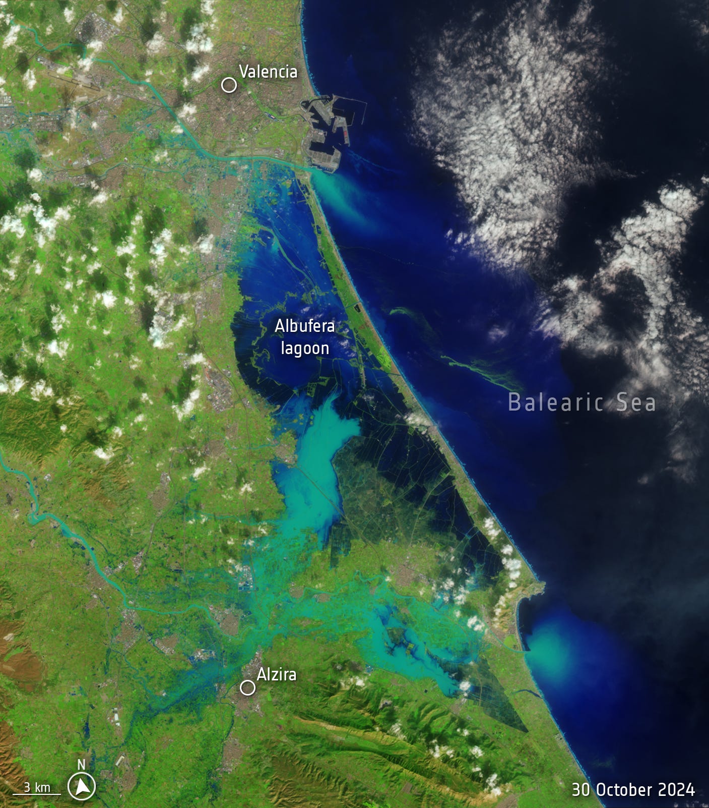
Valencia flood disaster [link]
"Spain is suffering its worst flood in decades after torrential rains struck the eastern province of Valencia. The death toll is climbing and people remain missing.
In response, the Copernicus Emergency Rapid Mapping Service has been activated to provide satellite imagery that can support rescue and recovery efforts.
According to Spain’s national weather agency, Aemet, on 29 October 2024, Valencia received a year’s worth of rain in just eight hours. This deluge caused devastating flash floods, turning streets into rivers, destroying homes, and sweeping away vehicles."

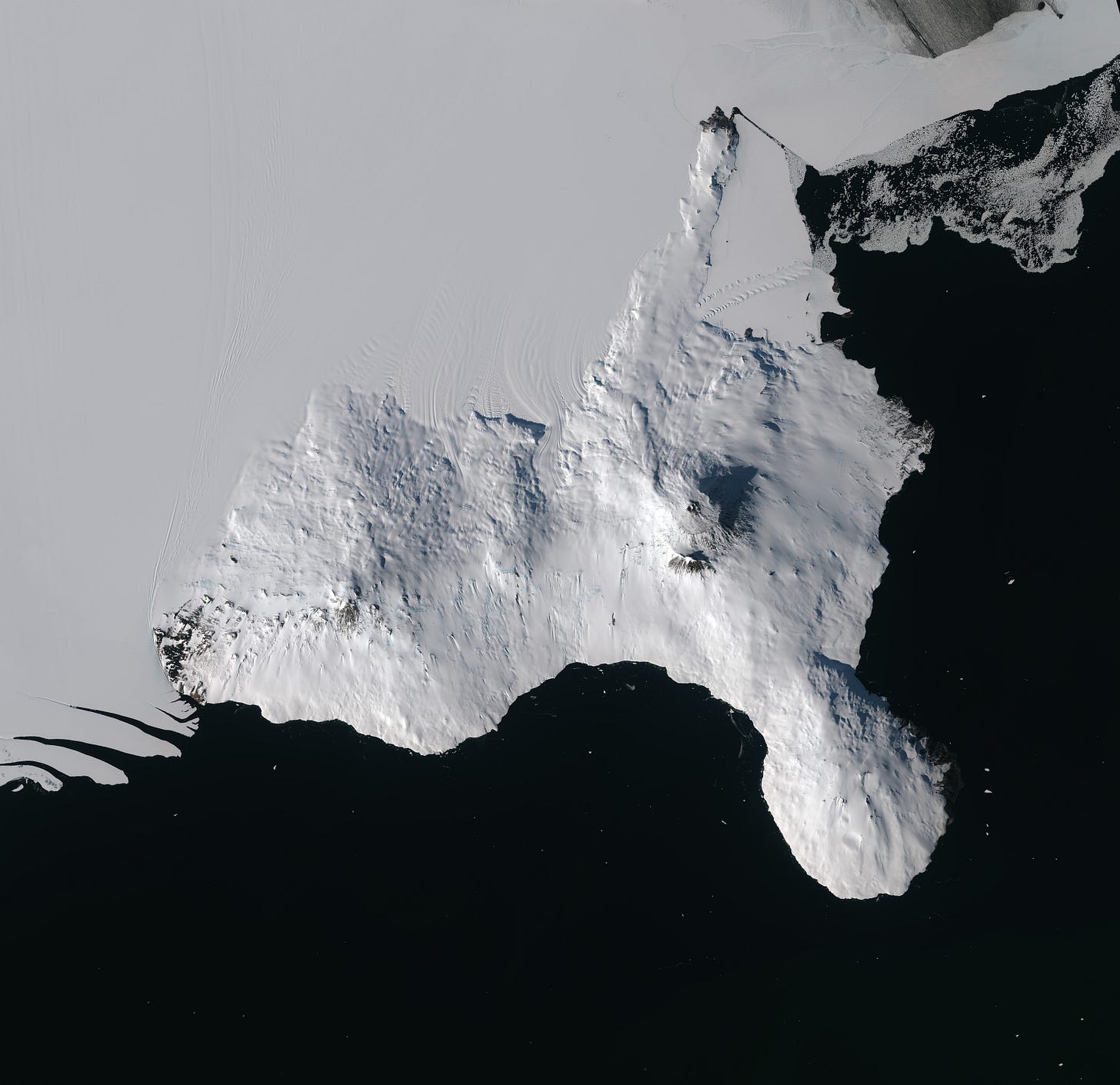
Earth from Space: Ross Island, Antarctica [link]
"Ross Island, covering around 2460 sq km, lies in Eastern Antarctica at the edge of the vast Ross Ice Shelf, a small fraction of which is visible in the upper part of the image. The island was named after the British explorer Sir James Clark Ross, who discovered it in 1841 during his quest for the magnetic South Pole."
Interesting reads
Anticipation of Hyperspectral [link]
Follow this article, by Adam Keith, as he explores the rise of commercial hyperspectral imaging in Earth observation.

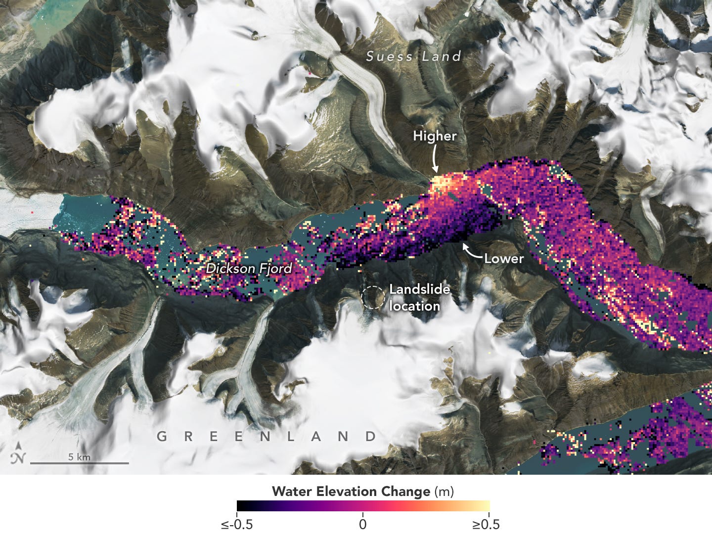
International SWOT Satellite Spots Planet-Rumbling Greenland Tsunami [link]
"The international Surface Water and Ocean Topography (SWOT) satellite mission, a collaboration between NASA and France’s CNES (Centre National d’Études Spatiales), detected the unique contours of a tsunami that sloshed within the steep walls of a fjord in Greenland in September 2023. Triggered by a massive rockslide, the tsunami generated a seismic rumble that reverberated around the world for nine days. An international research team that included seismologists, geophysicists, and oceanographers recently reported on the event after a year of analyzing data."

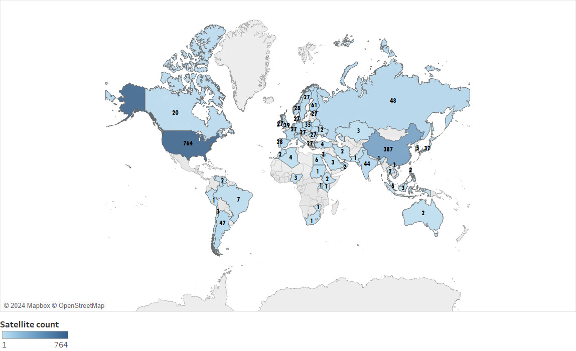
Earth Observing Satellites [link]
"The images in this post by the USGS display the countries that have owned and/or operated Earth observing satellites, and the number of satellites launched each year. The data represented in these images are gathered from various sources and are updated regularly by the USGS ECCOE team."
Ozone Hole Continues Healing in 2024 [link]
"A hole that opens annually in the ozone layer over Earth’s southern pole was relatively small in 2024 compared to other years. Scientists with NASA and the National Oceanic and Atmospheric Administration (NOAA) project the ozone layer could fully recover by 2066.
During the peak of ozone depletion season from September 7 through October 13, the 2024 area of the ozone hole ranked the seventh smallest since recovery began in 1992, when the Montreal Protocol, a landmark international agreement to phase out ozone-depleting chemicals, began to take effect."
How marine heatwaves impact phytoplankton and ocean health [link]
"Marine heatwaves – periods of prolonged, unusually warm seawater – are increasingly threatening marine ecosystems around the world. A recent study, led by the Institute of Marine Sciences of the National Research Council of Italy (CNR-ISMAR) as part of ESA’s CAREHeat project, specifically examined these effects in the North-Western Mediterranean Sea.
By combining satellite data from ESA’s Climate Change Initiative (ESA CCI), in situ robotic platforms called BioGeoChemical-Argo floats and Copernicus Marine’s biogeochemical models, the research highlights how these heatwaves significantly disrupt the spring phytoplankton bloom – a vital process for marine life."
LANDFIRE marks 20 years as one-stop data shop for fire - and more [link]
"LANDFIRE (short for Landscape Fire and Resource Management Planning Tools) data are hosted at the USGS Earth Resources Observation and Science (EROS) Center—which provides much of the data crunching expertise for the project. But LANDFIRE is a true interagency success story, with remarkable collaboration between the U.S. Departments of Interior and Agriculture and partnership with The Nature Conservancy. The LANDFIRE program has created far-reaching benefits for everyday Americans beyond its primary mission of fire management support."
Related:
Listen to to the Eyes on Earth Episode 125, under the "Podcasts" section of the newsletter.
Podcasts
Eyes on Earth Episode 125 – The LANDFIRE Program at 20 [link]
"This episode features the Landscape Fire and Resource Management Planning Tools (LANDFIRE) project, which is commemorating its 20th year of providing geospatial data to support natural resource management and wildland fire planning. LANDFIRE brings a lot of data together, over 30 data products, into one place. The publicly available, consistent data maps disturbance to the landscape and vegetation condition, which can be useful to virtually any application that deals with what’s occurring on the landscape. LANDFIRE has now been doing this for 20 years, and this episode hosts some of the people who have been working on LANDFIRE that entire time."
Eyes on Earth Episode 126 – Annual NLCD [link]
"The next generation of USGS land cover mapping is here. Annual NLCD provides land cover data of the U.S. every year back to 1985.
The topic of this episode is the latest release of the National Land Cover Database (NLCD). More than just a map, NLCD is a stack of maps—a database. It has long been the foundational land cover source for scientists, resource managers, and decision-makers across the United States, and now the next generation of USGS land cover mapping is here. This new release includes land cover data of the United States for every year back to 1985, so it is now called Annual NLCD."
Upcoming Events
From Satellite Data to Images in Minutes with EUMETView [link]
"Join this online course starting on 12 November. In four weeks, it'll take you from the fundamentals of EUMETView to advanced integrations and API interactions, providing all the tools you need to leverage EUMETSAT’s data for real-world applications.
Each session is hands-on, guided by EUMETSAT’s Data Access Team, and offers access to invaluable resources, interactive materials, and collaboration with peers. This is a fantastic opportunity to enhance your data skills, create shareable visuals, and learn practical workflows."
Competitions
REACT (EO4SDG) Competition – 3rd Edition [link]
"The EO4SDG (Earth Observation for Sustainable Development Goals) mini-projects are dynamic initiatives designed by IEEE Geoscience and Remote Sensing Society’s Technical Committee REACT (Remote sensing Environment, Analysis, and Climate Technologies)
Participants should focus on local or regional challenges, highlighting how remote sensing can raise awareness and drive sustainable actions. Projects may concentrate, for instance, on the Pacific Islands, agriculture and food security in India, flood and water security in Africa, or cryosphere changes in the Hindu Kush-Karakoram-Himalayas (HKH) region, despite submissions on other topics and regions are also encouraged."
Deadline: November 15, 2024
Learning
Advancing GeoAI: Harnessing Google Gemini for Geospatial Data Exploration & SAM2 for Remote Sensing Image Segmentation [link]
A recent keynote at the ACM SIGSPATIAL GeoAI Workshop, by Qiusheng Wu.

