

Level-2 News
Korean SAR satellite firm Lumir goes public; Shares slide after initial rally [link]
"South Korean satellite developer Lumir saw its share decline steadily following a brief rally on its first day of trading.
Since going public on South Korea’s KOSDAQ exchange Oct. 21 to raise capital for a constellation of synthetic aperture radar (SAR) imaging satellites, shares in Lumir have fallen, closing Oct. 28 at 9,120 won ($6.59), down 24 percent from its initial public offering (IPO) price. The closing price gives the company a market capitalization of 156.4 billion won, or roughly $110 million."
ESA plans measures to help European space industry [link]
"The European Space Agency is proposing steps to support a space industry that has been “under pressure” recently while keeping a watchful eye on one proposed deal.
During a media briefing after an ESA Council session Oct. 24, ESA officials said they are proposing changes such as increasing the size of downpayments on new contracts to provide a lifeline to companies that have struggled in the broader commercial market."
Developer's Orbit
New tutorials help navigate Landsat data in the cloud [link]
"Tutorials are now available to provide guidance and help users access, query, and use Landsat data directly from the USGS cloud storage location."
EROS User Services code repository [link]
Data
European Ground Motion Service releases latest product update [link]
"The European Ground Motion Service (EGMS) has just released its latest update. With this, EGMS now covers the reference period of 2019 to 2023.
This update follows the established production methodology and also maintains the continuity of the EGMS Viewer, ensuring consistency and reliability for users. In line with previous updates, it results in an extensive dataset of approximately 13 billion measurement points, preserving the EGMS's ability to detect and monitor ground motion phenomena with high precision across Europe."

Snapshots
Petit Saut Reservoir [link]
"In northeastern South America, the Sinnamary River winds its way north for 250 kilometers (160 miles) through forested French Guiana. Before spilling into the Atlantic Ocean, the river’s flow is interrupted by a dam upstream.
Between 1989 and 1994, a hydroelectric dam, known as Petit Saut (“little jump”), was constructed 70 kilometers inland from the mouth of the river. Damming the river created a reservoir, which can be seen in the false-color image above, acquired by the OLI-2 (Operational Land Imager-2) on Landsat 9 on October 1, 2024."
Climate
What is La Niña? Expert explains how the weather pattern may impact your winter plans [link]
"Follow this article where Northeastern University Professor Samuel Munoz explains how La Niña might bring snowy conditions to the Northwest and warmer, drier weather to the South this winter. Munoz cautions that while La Niña influences weather patterns, it doesn’t guarantee specific outcomes. This ancient climate cycle affects regions worldwide, but its impact can vary significantly each year."
Climate change intensified 2022 drought in Central and Southern Europe, study finds [link]
"A research team coordinated by the Helmholtz Centre for Environmental Research (UFZ) has now discovered that more than 30% of the extraordinary intensity and physical extent of the drought can be attributed to human-induced climate change. As they write in an article for Nature Geoscience, this extreme event was exacerbated by the fact that climate change had already caused soil moisture levels to drop continuously over the previous years.
The extreme drought severely affected public life in many countries in Central and Southern Europe between June and August in the summer of 2022. For example, half the population in Italy faced water restrictions, while in France more than 100 municipalities were supplied with drinking water via trucks."
Torrents of Sediment-Laden Water Worsened Disastrous Libyan Floods [link]
"The deadliest flood in Africa within the past 100 years didn’t happen in the continent’s rain-soaked equatorial jungles or along the mighty Nile, Congo, and Niger Rivers. It happened in Libya, along its dry northern coast.
When the Mediterranean cyclone Storm Daniel slunk down from Greece to strike Libya’s northern coast in September 2023, it unleashed flash floods that took thousands of lives and left some 45,000 people displaced.
Now, new research shows that enhanced soil erosion in Libya loaded Storm Daniel’s floodwaters with high amounts of sediments, increasing their destructive power."
NASA Helps Find Thawing Permafrost Adds to Near-Term Global Warming [link]
"A new study, co-authored by NASA scientists, details where and how greenhouse gases are escaping from the Earth’s vast northern permafrost region as the Arctic warms. The frozen soils encircling the Arctic from Alaska to Canada to Siberia store twice as much carbon as currently resides in the atmosphere — hundreds of billions of tons — and most of it has been buried for centuries."
Interesting reads
Addressing the need for harmonised greenhouse gas emission data sources [link]
"A new paper published as part of the ramp-up of the new CAMS greenhouse gas emission monitoring services makes a thorough comparison of observation- and inventory-based methane emissions datasets for the European Union and seven of the largest methane emitting countries.
The exercise, building on the extensive work of the EU-funded CoCO2 project, compares the official UNFCCC reported emissions with alternative observation-based methodologies and proposes a useful baseline to harmonise future reporting. By systematically comparing the different methods, the study provided recommendations for more robust comparisons of available data sources and hopes to steadily engage more parties in using observational methods to complement their UNFCCC greenhouse gas inventories, as well as considering their natural emissions."
Paper:
Comparison of observation- and inventory-based methane emissions for eight large global emitters [link]
Thin cool surface skin boosts ocean’s carbon uptake [link]
"New research, partially funded by ESA, reveals that the cool ‘ocean skin’ allows oceans to absorb more atmospheric carbon dioxide than previously thought. These findings could enhance global carbon assessments, shaping more effective emission-reduction policies."
MAPTCHA – a platform where citizen science meets Earth observation for fast emergency responses [link]
"Imagine you are about to sign up for a new service or make a purchase online, and suddenly you face the following challenge – “Select all the images with traffic lights”. Sounds familiar, correct? This is Human CAPTCHA (hCAPTCHA – Completely Automated Public Turing test to tell Computers and Humans Apart), a digital gatekeeper designed to distinguish human users from automated bots.
Now, consider the following scenario: you are looking at a satellite-derived image and you see a fire starting to develop. What if there was a quick way to flag this occurrence, enabling fast responses and informed decisions from emergency teams? This is exactly what MAPTCHA, a citizen science-based project, is trying to accomplish. MAPTCHA – just like “CAPTCHA”, but for “Maps” – is being developed by Osir.io and RSS-Hydro, in collaboration with ESA Φ-lab."
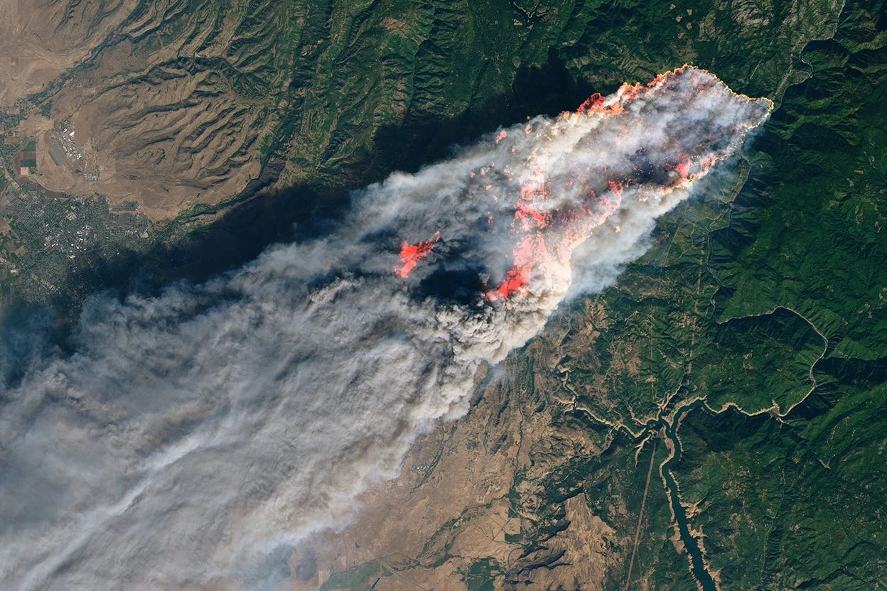
Wildfires Are Moving Faster and Causing More Damage [link]
"The fastest-moving wildfires are by far the most destructive because they force firefighters to focus on saving lives — instead of saving property.
Now, researchers have worse news: Wildfires are growing faster with climate change.
That’s according to a new analysis that used satellite data to examine tens of thousands of wildfires between 2001 and 2020. The researchers found that the fastest moving blazes were responsible for nearly 90 percent of damaged and destroyed homes, despite making up just 3 percent of fires during the period.
And the phenomenon is accelerating. The paper, published last week in the journal Science, warns that fires are spreading more quickly in the Western U.S. as climate change fuels warmer and drier conditions, posing a growing threat to already at-risk communities near forests and grasslands."
Paper: The fastest-growing and most destructive fires in the US (2001 to 2020) [link]
Related:
Extreme fire seasons are looming — science can help us adapt [link]
"Not all wildfires can be averted, but data, models and collaborations can help to chart a course to a fire-resilient future."
Key innovations in disaster management as presented at the CEMS Annual Conference 2024 [link]
"In 2023, over 90 million people worldwide were affected by disasters ranging from floods and wildfires to droughts. In a world where so many are impacted, there is a critical need for effective early warnings, monitoring efforts, and emergency response tools.
The Copernicus Emergency Management Service (CEMS) plays a pivotal role in addressing this need by providing timely geospatial information and continually innovating to improve the quality and fitness-for-purpose of its products.
This week's Observer looks at some of the key innovations presented at the CEMS 2024 Annual Conference, as well as future plans for the Service."
Report details fossil fuel threat to 'Amazon of the seas' [link]
"Fossil fuel exploration is threatening an ever-expanding swath of the Coral Triangle, one of the most biodiverse marine areas in the world, a report said Saturday.
Issued to coincide with the UN's COP16 summit on biodiversity in Colombia, the report warned expansion in oil, gas and liquefied natural gas (LNG) in the Indo-Pacific region was putting at risk marine species and the communities that rely on them.
Dubbed the "Amazon of the seas" for its species variety, the Coral Triangle covers over 10 million square kilometers (some four million square miles) in waters of Indonesia, Malaysia, Papua New Guinea, Singapore, the Philippines, Timor-Leste and the Solomon Islands.
Since July 2020, satellites have spotted 793 oil slicks in the Coral Triangle, said the report."
USGS satellites and test tubes meet to ensure safe drinking water [link]
"From space, it can be more challenging because of water’s light absorbing qualities. Scientists from the USGS Earth Resources Observation and Science (EROS) Center are working with other USGS researchers to find more ways to use Landsat satellite data and other remotely sensed data to identify harmful algal blooms (HABs) on Earth.
The goal is to coordinate efforts across the USGS to use every resource available to give policy makers information as quickly as possible to warn the public of potential issues. HABs can pollute drinking water sources and make recreational water bodies unsafe to swim in. Harmful algal blooms can produce toxins that are potent enough to threaten people’s wellbeing. Aquatic life and habitat conditions are threatened when HAB levels grow too much."
LinkedIn Highlights
“value drivers” and “operational enablers” [link]
Follow Aravind's recent post to explore how Earth Observation application companies tackle two core use case types: “value drivers” and “operational enablers.”
Upcoming Events
Atlas of the Human Planet 2024 launch event [link]
"Buildings, cities and population: for over 20 years, the Joint Research Centre has been mapping the human presence on earth from space. This crucial data has recently been integrated into the Copernicus Emergency Management Service, enabling more effective management and response to emergencies.
This new edition of the Atlas of the Human Planet offers an unprecedented 50-year perspective on population growth and urbanisation trends across the world.
Join this online launch event to explore how information on population and human settlements derived from Copernicus satellites can help tackle a broad spectrum of societal challenges.
Wednesday 30 October 2024, 10:00 - 12:00 (CET)"
Learning
Introduction to GIS Programming [link]
"This course offers a comprehensive exploration of GIS programming, centered around the Python programming language. Throughout the semester, students will master the use of Python libraries and frameworks essential for processing, analyzing, and visualizing geospatial data.
All course materials, including video recordings, are freely available on the course website: geog-312.gishub.org."
Video Recordings [link]