

Hurricane Milton seen from space as it approaches Florida
"NASA astronaut Matthew Dominick got a view of Hurricane Milton as it churned across the Gulf of Mexico towards Florida’s west coast."
Level-2 News
Sentinel-1C arrives in French Guiana [link]
"The Sentinel-1C satellite, the third satellite of the Copernicus Sentinel-1 mission, has arrived at the European spaceport in French Guiana for liftoff on the Vega-C rocket at the end of 2024. The satellite will continue the critical task of delivering key radar imagery of Earth’s surface for a wide range of Copernicus services and scientific applications.
Sentinel-1A was the first satellite in the series, launched in April 2014, followed by the launch of Sentinel-1B in 2016. The Sentinel-1B mission came to an end in December 2022 after experiencing a technical fault that rendered it unable to acquire data. The satellite has been successfully de-orbited and will re-enter Earth’s atmosphere within 25 years.
Sentinel-1C will soon take over the role of Sentinel-1B in the mission."
Iceye Debuts 25 cm SAR Imagery Resolution [link]
"Iceye now has the capability to offer 25 cm resolution for its synthetic aperture radar (SAR) imagery. The new feature is called “Dwell Precise” and it is based on the 1200 MHz radar bandwidth,which is the maximum that commercial satellites are allowed to use.
The company said this capability combines high quality data and high resolution, which will make a difference to identify smaller objects or targets. Iceye said this level of resolution could enable military forces to identify types of vehicles and military equipment without additional intelligence."
Planet Data Used for Sugarbeet Crop Monitoring in New Agriculture Contract [link]
"Planet’s satellite data informs sugarbeet crop monitoring under a new contract between Planet partner SatAgro and American Crystal Sugar Company.
Sugarbeet is a root crop with a high concentration of sucrose that is processed into sugar. American Crystal Sugar is a grower-owned cooperative and is the largest beet sugar producer in the U.S.
Under the contract, American Crystal Sugar will analyze PlanetScope satellite data within SatAgro’s interface for insights into harvest progression, yield formation speed and yield forecast. This data will support decisions on crop management. SatAgro has worked with American Crystal Sugar for a number of years to bring digital farming tools to the company."
NASA, Smithsonian Open New Exhibit to Showcase Our Dynamic Earth [link]
"NASA Administrator Bill Nelson joined the director of the Smithsonian’s National Museum of Natural History in Washington and agency leadership to unveil the new Earth Information Center exhibit during an early preview on Monday.
The exhibit includes a 32-foot-long, 12-foot-high video wall displaying Earth science data visualizations and videos, interpretive panels showing Earth’s connected systems, information on our changing world, and an overview of how NASA and the Smithsonian study our home planet.
It opened to the public Tuesday, Oct. 8."
EO Providers Defend Their Spectrum Access [link]
"Commercial EO providers contribute to sectors ranging from agriculture to climate monitoring to defense—and now they’re banding together to make sure policymakers know the results of an administration-ordered study could put all of that in jeopardy.
The conflict: The terrestrial mobile industry, aka cell phones, are seeking to use a large band of spectrum for 6G connectivity. But government and commercial EO providers already use the top part of that band for downlink of Earth imagery.
This X-band is particularly well-suited for EO data downlink, and losing exclusive access to it could result in the EO industry facing interference and limited growth, according to industry officials."
ESA’s To-Do List for an EO Boom [link]
"ESA published its new Earth Observation Science Strategy on Monday, outlining the agency’s plans to grow the region’s EO capabilities over the next 10-15 years by prioritizing research into the areas that officials believe can have the biggest impact on humanity.
The bottom line: The strategy commits to utilizing commercial EO capabilities wherever possible, reaffirming ESA’s strong public-private relationship—one that’s been vital to helping companies in the region flourish."
Developer's Orbit
WeatherGenerator project aims to recast machine learning for Earth system modelling [link]
"ECMWF is coordinating an EU Horizon project called WeatherGenerator which aims to use machine learning in novel ways for weather forecasting and to model related Earth system processes."
Data
NLCD’s path from early landscape snapshot to decades of change [link]
"The widely used National Land Cover Database (NLCD) has long been the foundational land cover source for scientists, resource managers, and decision-makers across the United States, trusted for its accurate and unbiased data.
The article explores the evolution of NLCD through its reinvention this year as Annual NLCD."

Snapshots

Three Storms Churn in an Active Atlantic [link]
From the stable Lagrange point 1, located one million miles above Earth, NASA’s EPIC (Earth Polychromatic Imaging Camera) imager on the DSCOVR (Deep Space Climate Observatory) satellite observed an unusually active Atlantic Basin.
In early October, three hurricanes simultaneously spun over the North Atlantic Ocean."
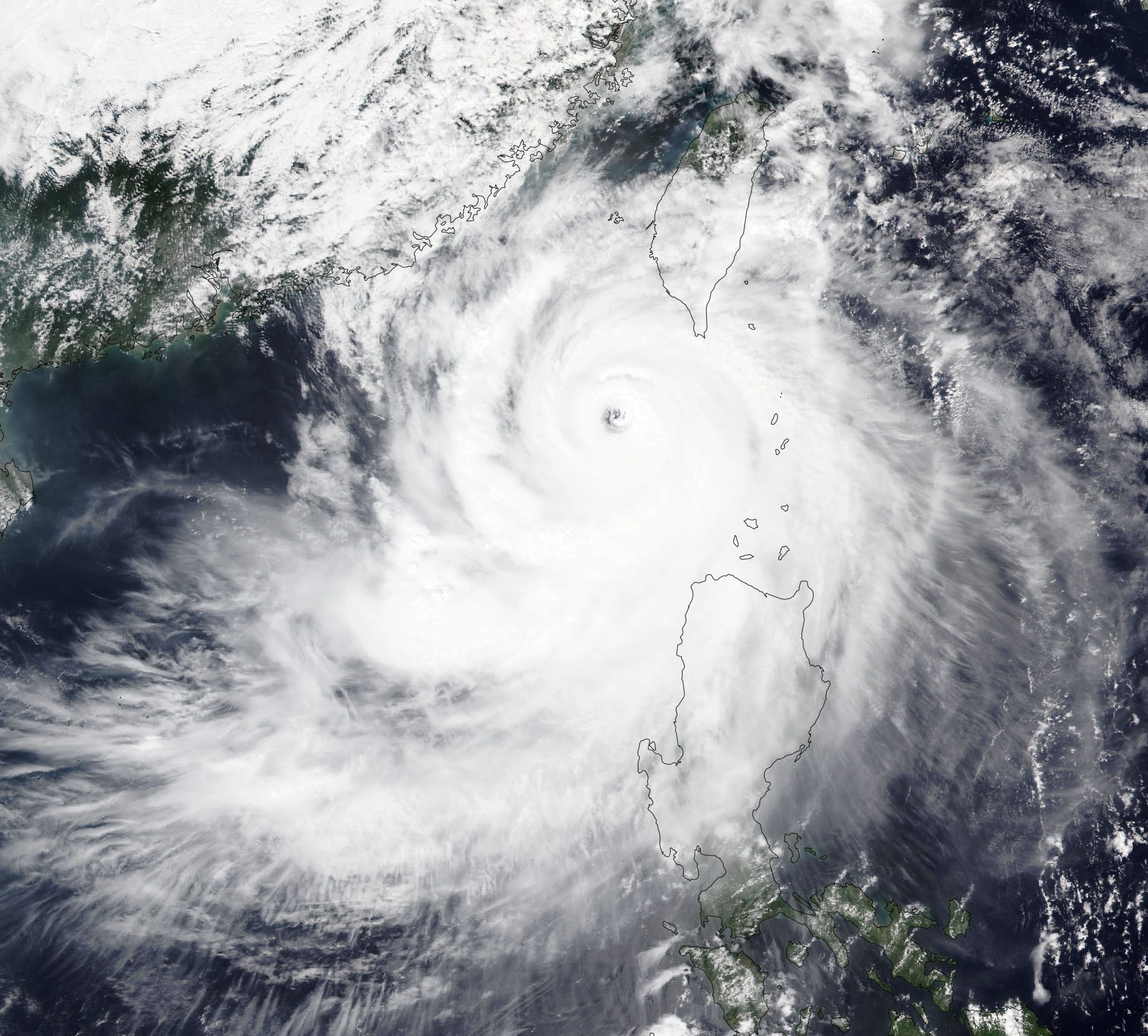
Typhoon Krathon Nears Taiwan [link]
"Typhoon Krathon lingered off the coast of southwestern Taiwan in early October 2024 and is forecast to batter the idland’s populated west coast with torrential rain and damaging winds.
On its way to Taiwan, Krathon first thrashed northern parts of the Philippines, where the storm is known as Typhoon Julian. Its strong winds damaged roofs and toppled trees in the Philippine province of Batanes on September 29 and 30, according to news reports. The storm continued to strengthen as it moved northwest."
Climate
The latest Ocean State Report highlights record heat, shrinking sea ice, and innovations for a changing ocean [link]
"The most recent edition of the EU Copernicus Ocean State Report (OSR 8) reveals a changing ocean, with record-breaking temperatures, dwindling polar sea ice, and marine heatwaves, including those in the Mediterranean Sea, which penetrated to depths of up to 1500 metres below the surface of the ocean. Other regions, such as the Baltic Sea and the Iberian-Biscay-Ireland region, also experienced significant marine heatwaves. The OSR 8 also shows the pace and extent of ocean warming due to anthropogenic greenhouse gas emissions and introduces a range of new technologies and innovations helping to improve humanity’s relationship with the ocean."
Interesting reads
Dust sparked biggest phytoplankton bloom in decades [link]
"Carried by the wind, dust clouds can travel vast distances. For instance, dust from the Sahara Desert often crosses the Atlantic Ocean to the Americas. When these particles settle on land or in the ocean, they deliver essential nutrients that may boost plant growth and ocean productivity, including marine phytoplankton."
GPM Celebrates Ten Years of Observing Precipitation for Science and Society [link]
"On February 27, 2014, the four-ton Global Precipitation Measurement (GPM) Core Observatory (CO) spacecraft launched aboard a Japanese H-IIA rocket from Tanegashima Space Center in southern Japan. On that day, the GPM mission, a joint Earth-observing mission between NASA and the Japan Aerospace Exploration Agency (JAXA), began its journey to provide the world with an unprecedented picture of global precipitation (i.e., rain and snow). GPM continues to observe important precipitation characteristics and gain physical insights into precipitation processes using an advanced radar and passive microwave (PMW) radiometer on the GPM–CO along with leveraging a constellation of satellites."
The Increasing Allure of Polar Orbits: An Explainer [link]
"Not all orbits are created equal. Satellite operators have many options when deciding where to send their birds, each offering tradeoffs in Earth coverage, image resolution, data download latency, orbital congestion, and launch costs.
Military, commercial, and climatological interests have increasingly picked polar orbits for a variety of missions, from surveillance and communications capabilities over remote regions, to better understanding the rapidly evolving impacts of climate change on the polar ice caps.
From OneWeb 20, expecting to launch on Falcon 9 this week, to SpaceX’s crewed Fram2 mission, which could launch as soon as this year, there’s been a notable uptick in the amount and scope of missions heading over the poles. "
Landsat 7 brough jobs, science, art and memories to USGS [link]
Follow this article to learn about the incredible 25-year journey of Landsat 7, from its launch in 1999 to its remarkable contributions in Earth Observation. Discover how this satellite helped shape the USGS EROS Center's capabilities and left a lasting impact on the scientific community, despite overcoming significant challenges along the way.