

Level-2 News

First Light Images from Tanager-1 Hyperspectral Satellite [link]
"Planet released their first light images from our Tanager-1 hyperspectral satellite. The first set of imagery is of Karachi, Pakistan, and was taken on September 19th, 2024, from an altitude of 522 km."
NOAA Works with Industry to Determine Natural Language Processing Capabilities with the NCCF Open Knowledge Mesh [link]
"On Sept. 13, NOAA awarded Knowledge Mesh/Natural Language Processing (KM/NLP) contracts with a cumulative value of $5.4 million to four companies.
These awards are to examine, deliver, and iteratively demonstrate working models, features, and capabilities related to the development and management of an enterprise information processing system, backed by a knowledge mesh of process contextualized, semantically enabled facts that is capable of dynamically leveraging Application Programming Interface (APIs)."
BlackSky to equip its future satellites with military-compatible laser terminals [link]
"BlackSky won a U..S. Navy contract to study the compatibility of its Gen-3 satellites with military ground terminals."
Developer's Orbit
Run AI models yourself from ECMWF open data [link]
"The Artificial Intelligence/Integrated Forecasting System (AIFS) team announced that users can now run AI models using ECMWF's open data themselves. This breakthrough democratizes access to cutting-edge weather forecasting technology and opens new possibilities for research, education, and application development."
Data
From September 26, 2024, the legacy CDS and legacy ADS are decommissioned and no longer accessible [link]
"A new Climate Data Store (CDS) and a new Atmosphere Data Store (ADS) powered by a new state-of-the-art infrastructure, referred to as the Common Data Store (CDS) Engine are now open!
All layers of the CDS an ADS infrastructure are being modernised: the front-end web interface, the back-end software engine and the underlying cloud infrastructure hosting the service and core data repositories."
CDS: https://cds.climate.copernicus.eu/
ADS: https://atmosphere.copernicus.eu/
New Application Informs Users About Reprocessed Landsat products [link]
"A newly released search application from the U.S. Geological Survey (USGS) helps users track Landsat products that have been reprocessed within Collection 2. While most of the data held in the USGS EROS Landsat archive are processed into a Collection only once, data affected by anomalies or disconnects may need to be reprocessed to replace impacted products."

Snapshots
TROPICS Tracks Hurricane Helene [link]
"The Time-Resolved Observations of Precipitation structure and storm Intensity with a Constellation of Smallsats (TROPICS) mission is a constellation of small satellites designed to monitor global precipitation events on a much more frequent basis than what large single satellites can do. It is a short term demonstration mission supporting the concept of high cadence small CubeSat weather observations. These small satellites can be much more cost effective than their much larger counterparts, and launching many of them can provide more frequent coverage.
TROPICS monitored Hurricane Helene throughout its lifecycle. This data visualization shows how the Tropical Depression formed into a Category 4 hurricane before hitting Florida. Helene is one of the strongest hurricanes to ever hit Florida's west coast. It then continued inland, weakening to a Tropical Depression, while still causing catastrophic flooding as far inland as western North Carolina."
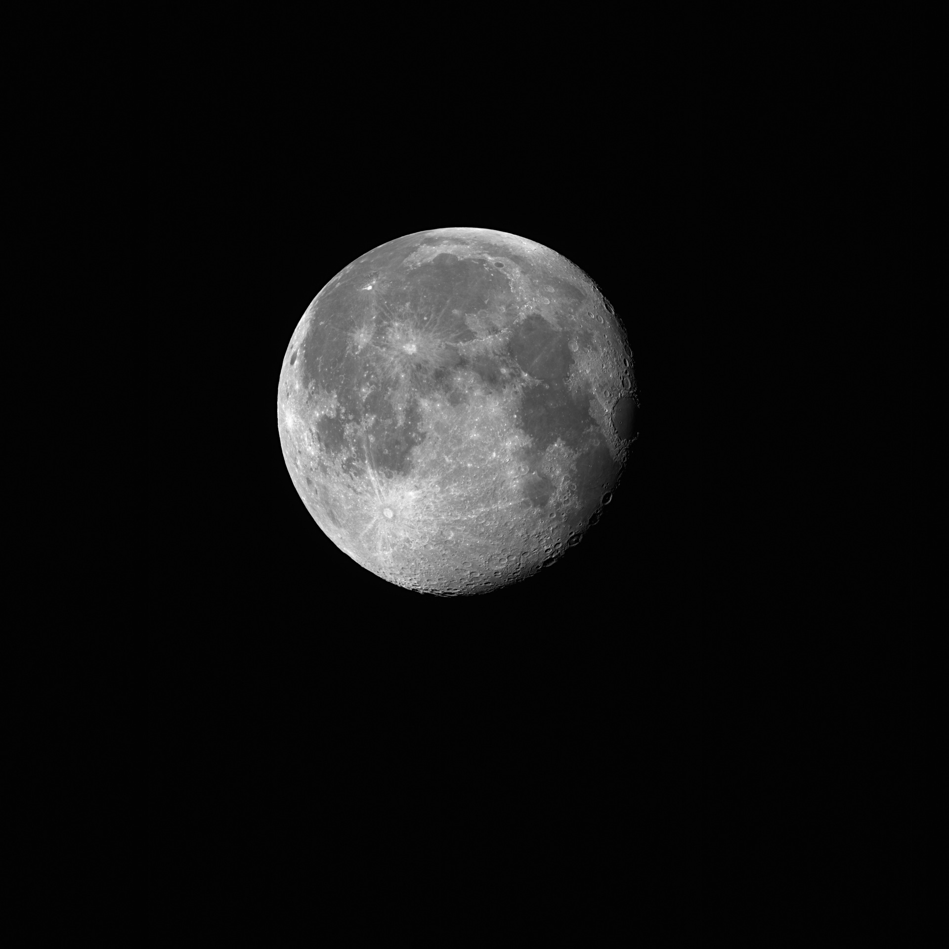
Sentinel-2C captures stunning glimpse of the Moon [link]
"On 20 September, the Copernicus Sentinel-2C satellite captured its first stunning image of the Moon, achieved by rolling the satellite sideways in a unique manoeuvre.
The image, with an impressive resolution of around 5 km, reveals notable lunar features, including the Copernicus Crater, the Tycho Crater and the lunar seas: the Sea of Tranquillity, the Sea of Moisture and the Sea of Clouds.
This lunar image is part of a regular 'Moon calibration' process. Roughly once a month, the satellite will roll sideways to image the Moon instead of Earth. The Moon's well-known and stable light intensity allows us to detect and correct even the smallest changes in the instrument's performance, which can occur due to aging, such as optical coating degradation or detector drifts."
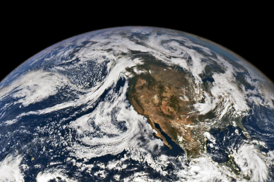
An Uncommonly Strong Atmospheric River [link]
"A powerful atmospheric river swept through the Gulf of Alaska in September 2024, bringing abundant rain to coastal British Columbia, Canada, and southeastern Alaska. Because of its duration and the concentration of moisture moving across the ocean, experts suspect this atmospheric river was among the most intense to transit the northeast Pacific in a satellite-based record going back to 2000.
The ribbon of clouds delivering precipitation to the region was still visible on September 24, when NASA’s EPIC (Earth Polychromatic Imaging Camera) imager on the DSCOVR (Deep Space Climate Observatory) satellite captured an image from about 1 million miles above Earth."
Climate
NASA Analysis Shows Irreversible Sea Level Rise for Pacific Islands [link]
"Climate change is rapidly reshaping a region of the world that’s home to millions of people.
In the next 30 years, Pacific Island nations such as Tuvalu, Kiribati, and Fiji will experience at least 6 inches (15 centimeters) of sea level rise, according to an analysis by NASA’s sea level change science team. This amount of rise will occur regardless of whether greenhouse gas emissions change in the coming years."
Arctic Sea Ice Near Historic Low; Antarctic Ice Continues Decline [link]
"Arctic sea ice retreated to near-historic lows in the Northern Hemisphere this summer, likely melting to its minimum extent for the year on Sept.11, 2024, according to researchers at NASA and the National Snow and Ice Data Center (NSIDC). The decline continues the decades-long trend of shrinking and thinning ice cover in the Arctic Ocean.
The amount of frozen seawater in the Arctic fluctuates during the year as the ice thaws and regrows between seasons. Scientists chart these swings to construct a picture of how the Arctic responds over time to rising air and sea temperatures and longer melting seasons. Over the past 46 years, satellites have observed persistent trends of more melting in the summer and less ice formation in winter."
Interesting reads
Tracking environmental crime with Copernicus Land data [link]
"Crime scenes are not always confined to dark alleyways and abandoned warehouses—sometimes they are hidden in plain sight. Environmental crimes are illegal activities which directly harm the environment, often resulting in significant damage to ecosystems, biodiversity, and human health.
According to estimates by the European Union Agency for Criminal Justice Cooperation (Eurojust), environmental crime is the fourth largest criminal activity worldwide and one of the fastest growing types of crime, increasing at a rate of 5-7% a year globally. Industry and corporations are typically the biggest offenders (e.g., diesel emissions scandal and oil contamination of the Niger Delta) but organised crime also plays a significant role in areas such as wildlife trafficking and illegal timber harvesting."

Artificial intelligence and satellite data to improve climate projections [link]
"A research team led by Prof. Veronika Eyring from the DLR and the University of Bremen has developed an approach for integrating AI into Earth system models, publishing two Nature 'Perspectives' on future research priorities. Machine learning methods are set to significantly improve the accuracy and speed of projections. This novel approach has the potential to reduce limitations of current climate models, leveraging the AI-revolution for this crucial research field."
Making Geospatial More Approachable Through Clear Documentation: Meet UP42’s Documentation Lead, Daria Lutchenko [link]
"The geospatial industry can seem overwhelming, filled with complex terms and concepts that can often intimidate beginners. Clear and concise documentation is essential for making geospatial technology more approachable. It simplifies complex concepts, allowing users to quickly understand and utilize geospatial tools and data without feeling overwhelmed.
Daria Lutchenko works on this every day. As UP42’s Documentation Lead, her main goal is to explain things clearly, so that “even a beginner feels empowered to explore this beautiful world of geospatial data and the opportunities it presents."
Related:
Unraveling the art of documentation in the geospatial industry [link]
Podcasts
Beyond the Lab podcast [link]
"This is a new podcast series, hosted by Alessandro Novellino, in collaboration with Remote Sensing and Photogrammetry Society (RSPSoc) starting in September 2024!
What to Expect:
Discover the cool, innovative and inspiring work people are doing!
Understand why their work is crucial in the real world.
Hear inspiring stories about their career journeys and personal experiences.
In the latest episode, Alessandro Novellino interviewed Rachel Brooke Soobitsky! She’s currently part of the Goddard Space Flight Center Landslides team and NASA Disasters Program, where she helps analyze Earth observation data and coordinate responses to disasters around the world."
LinkedIn / X Highlights
A Colour Ramp You Will Love or Hate [link]
Follow this post by Iain Woodhouse on how color ramps can significantly influence our perception of map data. This post dives into the subtleties of different color palettes, from sharp perceptual boundaries that distort meaning to the intuitive clarity of well-chosen gradients that enhance data interpretation.
Little update on Source Cooperative [link]
"Now hosting over 400TB of data published by 64 organizations or individuals."
Take a look at Jed Sundwall's update on the Source Cooperative initiative.
"Why hasn't the satellite imagery market taken off?" [link]
Checkout this post by AyJay Lasater, co-founder and CTO at Albedo, on why hasn't the satellite imagery market truly taken off yet, and what's the fundamental flaw holding established players back.
Make sure to follow the discussion in the comment section!
Tasking a satellite via a… tweet! [link]
Follow Joe Morrison's tweet announcing the release of a SAR image from Lake Lure, North Carolina, just 3.5 hours after JD Work's request.
Two SAR images (50cm resolution), taken about 12 hours apart, can be found here.
Context: The Lake Lure dam overtopped Friday after Hurricane Helene inundated the area. [link]