

Sentinel-2C to Vega and orbit – fit-check to liftoff timelapse
"From the arrival of the Earth obversation satellite Sentinel-2C in July 2024 and the first fit-check to launch from Europe’s Spaceport in French Guiana, this timelapse shows how the third Sentinel-2 satellite was prepared for launch. The last Vega rocket, flight VV24, lifted off on 5 September at 03:50 CEST (4 September 22:50 local time)."
Level-2 News
NOAA, Esri team up to make ocean data more accessible and actionable [link]
"NOAA and Esri will create the prototype for a fully interoperable open data platform to provide equitable, actionable and ready-to-use ocean and coastal data for decision makers and communities.
The platform will leverage NOAA’s massive stores of data with Esri’s geospatial technical innovations and capabilities to help users address critical issues, with information tailored to their needs."
Planet signs three-year DLR contract [link]
"Planet announced a contract Sept. 16 to provide Earth-observation data and services to the German Space Agency DLR.
Under the agreement, DLR and German researchers will have access to PlanetScope products, including nearly daily imagery of Earth’s landmass at approximately three-meter resolution. The contract also covers the PlanetScope archive, which includes data from 2016 on.
In addition, the DLR will obtain Planet’s archive of RapidEye imagery over Germany. The archive includes imagery with a resolution of five meters per pixel obtained since 2009."
Capella Space lands $15 million U.S. Air Force contract for radar imaging upgrade [link]
"Capella Space, a provider of Earth observation services using synthetic aperture radar satellites, has been awarded a $15 million contract by the U.S. Air Force to modernize its sensor and data collection capabilities for military applications."
Lockheed Martin to Develop Lightning Mapper for NOAA GeoXO Satellites [link]
"NASA awarded Lockheed Martin a contract to design and build the next-generation GeoXO Lightning Mapper (LMX) instruments for the National Oceanic and Atmospheric Administration (NOAA) GeoXO satellites. The baseline contract announced Sept. 18 is valued at approximately $297 million for two instruments with options for two additional instruments."

Snapshots
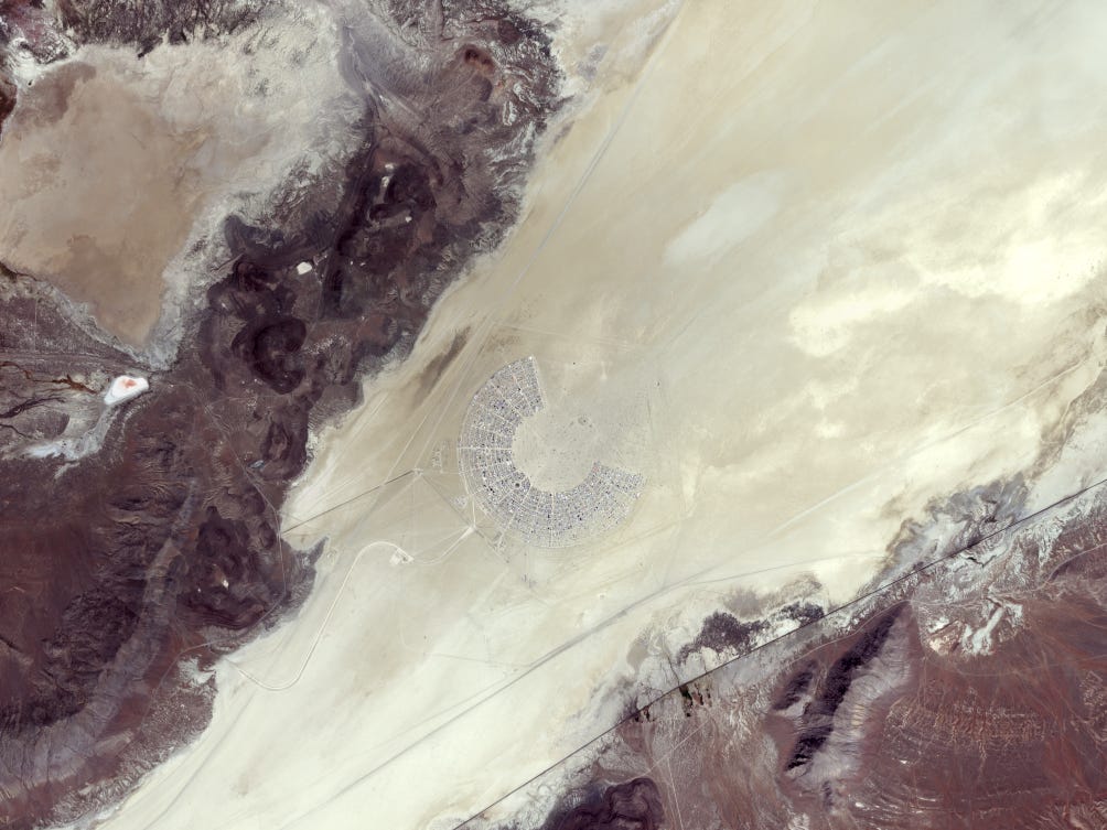
Earth from Space: Burning Man festival [link]
"Covering about 2600 sq km, the Black Rock Desert is an arid region of lava beds and alkali flats in northwestern Nevada. The picture, acquired on 26 August 2024, captures the white, sandy area in the southwestern part of the desert, where the Burning Man festival takes place annually.
Over 70 000 people gathered from 25 August to 2 September at Black Rock for the desert-based event. This image, taken from orbit on the second day of the event, shows the area of camper vans and tents grouped together for the week-long art and self-expression festival, which involves music, stunning art installations, experimental and interactive sculptures, and art cars, among others."
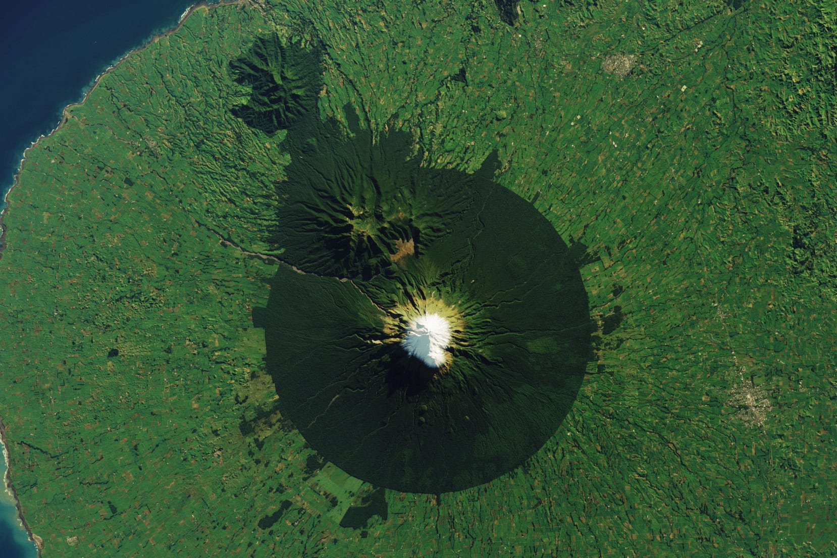
Mount Taranaki’s Ring of Forest [link]
"On New Zealand’s North Island, a conical snow-capped volcano ringed by dark green forest rises above dairy pasture. The often-snowcapped peak of Mount Taranaki (dubbed Mount Egmont by Captain Cook) is the centerpiece of Egmont National Park. A circular piece of land—with a 9.6-kilometer (6-mile) radius from the volcano’s summit—was first formally protected as a forest reserve in 1881. With some subsequent additions, it became New Zealand’s second national park in 1900."
Arctic weather satellite's first images capture Storm Boris [link]
"Just a month after its launch, ESA's Arctic Weather Satellite has already delivered its first images, notably capturing Storm Boris, which has been wreaking havoc across central Europe.
Equipped with a 19-channel cross-track scanning microwave radiometer, the satellite's mission is to penetrate the atmosphere and provide detailed temperature and humidity profiles in all weather conditions.
Despite its name, the Arctic Weather Satellite measures temperature and humidity at various altitudes around the world. However, its humidity data is particularly valuable for Arctic weather forecasting, as water vapor levels can change rapidly in this region.
The animation shows measurements from 14 September 2024 in terms of 'brightness temperature,' with lower values (depicted in blue) indicating higher humidity levels. Credit: European Space Agency"
Interesting reads
The Hitchhiker's Guide to Vector Embeddings in Machine Learning (for Geographers) [link]
Samapriya Roy breaks down the concept of vector emdeddings by drawing parallels between geographic practices such as mapping coordinates, calculating distances, and clustering. This approach helps readers gain a clearer understanding of how vector embeddings function and how they relate to familiar geospatial workflows.
Making Space Data Easier to Use: Overcoming Challenges and Expanding Access [link]
"Follow this article by Robert Simmon to explore the current challenges in accessing and utilizing satellite data for remote sensing. It outlines key obstacles such as complex data formats, cumbersome interfaces, and the steep learning curve of cloud-based tools.
The article offers potential solutions, focusing on enhancing usability, streamlining formats, and improving interfaces to make data more accessible to a broader range of users beyond traditional research communities."
NASA Data Helps Protect US Embassy Staff from Polluted Air [link]
NASA and the U.S. State Department have expanded ZephAir, a tool providing real-time air quality data, to include three-day forecasts for all 270 U.S. embassies and consulates worldwide, where approximately 60,000 U.S. citizens and local staff work. This collaboration offers crucial air quality predictions, especially for regions lacking local monitors, helping protect U.S. diplomatic staff and citizens abroad. Using NASA's satellite data and models, ZephAir empowers embassies to make informed decisions about health and safety; from building ventilation to outdoor activities at embassy schools; while contributing to global air quality awareness and action.
Revealing climate history through data rescue [link]
Data rescue plays a crucial role in understanding long-term climate trends by recovering and digitizing historical meteorological records. The Copernicus Climate Change Service (C3S) and the World Meteorological Organization (WMO) have launched a new data rescue portal, making it easier for users to contribute and access rescued climate data globally. This collaboration helps preserve invaluable historical records, which are essential for accurate climate modeling and policy development. By prioritizing regions with scarce data, these efforts aim to fill critical gaps in the global climate dataset.
Data Rescue Projects [link]
Learning
6th ECMWF CAMS, ESA, EUMETSAT Training in Atmospheric Composition Monitoring and Modelling - recordings available [link]
"The training is jointly organized by the European Center for Medium-Range Weather Forecasts (ECMWF) with the Copernicus Atmosphere Monitoring Service (CAMS), the European Space Agency (ESA), and the European Organisation for the Exploitation of Meteorological Satellites (EUMETSAT).
The main objective of the course is to provide a holistic introduction to the end-to-end processes involved in atmospheric composition monitoring and modelling."
For more information, please visit the event website.