Level-2 News
NASA Selects Companies for Commercial SmallSat Services Award [link]
"NASA has selected eight companies for a new award to help acquire Earth observation data and provide related services for the agency.
The selectees are:
BlackSky
ICEYE US
MDA Geospatial Service Inc.
Pixxel
Planet Labs
Satellogic
Teledyne Brown Engineering
Tomorrow.io"
ICEYE to deliver SAR satellites and data to Greece’s National Satellite Space Project in collaboration with the European Space Agency [link]
"ICEYE announced signing the contract for the Greek National Satellite Space Project Axis 1.2 (radar program) for the Greek Space Agency and Greek Ministry of Digital Governance, together with the European Space Agency.
Axis 1.2 covers the Greek SAR Space Segment and includes both radar imagery and the development of a Greek Observation System with two ICEYE SAR satellites, and their launches.
In addition to sovereign satellites, Greece will also have access to ICEYE’s existing SAR satellite constellation, the largest in the world, and can start monitoring its areas of interest already while building its space capabilities."
Related:
This announcement follows Greece's contracting of Open Cosmos to build seven satellites for daily high-resolution and very-high-resolution imagery [link], and OroraTech, which will build four thermal satellites [link].
Planet Reports Financial Results for Second Quarter of Fiscal Year 2025 [link]
"Planet announced financial results for the period ended July 31, 2024."

Tomorrow.io's first two microwave sounder satellites capture initial atmospheric observations [link]
"Tomorrow.io's first two microwave sounder satellites, Tomorrow-S1 and Tomorrow-S2, have successfully captured initial atmospheric observations within days of their August 16 launch.
While calibration is ongoing, both Tomorrow-S1 and Tomorrow-S2 are already integrated into the Tomorrow.io platform for real-time tracking."

Developer's Orbit
Lonboard & GeoArrow Rust in Project Jupyter's JupyterLite [link]
"Lonboard & GeoArrow Rust in Project Jupyter's JupyterLite, all running in WebAssembly right in your browser! No server required!
Try it out here."
Related:
Kyle Barron technical presentation "WebAssembly in parquet-wasm and Lonboard" [link]
Data
Earth Science Data Roundup: September 2024 [link]
"A summary of datasets, products, and resources released by NASA's Distributed Active Archive Centers (DAACs) in August 2024."
Some of the dataset:
New Tutorials for Working with NISAR Sample Data
New STAQS Datasets
Rapid X-Band Polarimetric Radar (RaXPol) IMPACTS Dataset Released
New Datasets from TROPICS Smallsats 3, 5, 6, and 7 Now Available
GEDI Version 2 Data Subsetting Now Available in NASA's Earthdata Search
ECOSTRESS Version 2 Level 3 Evapotranspiration and Level 4 Evaporative Stress Index and Water Use Efficiency Tiled Data Are Now Available in AppEEARS
Geoscience Australia's Historical Aerial Photography collection, containing 1.2 million aerial photos from the 1920s onward! [link]
Explore the dataset here.
Snapshots
Smoke Fills South American Skies [link]
"Intense fires burning in several South American countries draped large swaths of smoke across the continent throughout August and early September 2024."
"They came, they partied, they left" [link]
"10 days of burning man (“blue is new, red is fled”)"
SAR imagery of Burning Man 2024 in Black Rock City, Nevada, captures the buildup and breakdown of the event.

California’s Park Fire Spread Fast and Hot [link]
"About a month after igniting on July 24, 2024, the Park fire charred nearly 670 square miles (170,000 hectares) of land in Northern California, according to a situation report from the National Interagency Fire Center. As of late August, the fire ranked as the state’s fourth-largest fire on record and its largest fire so far in 2024."
Related:
Looking at California's 4th largest fire with ECOSTRESS data [link]
Check out Wanmei Liang's LinkedIn post where she lists related tutorials and data sources.
Climate
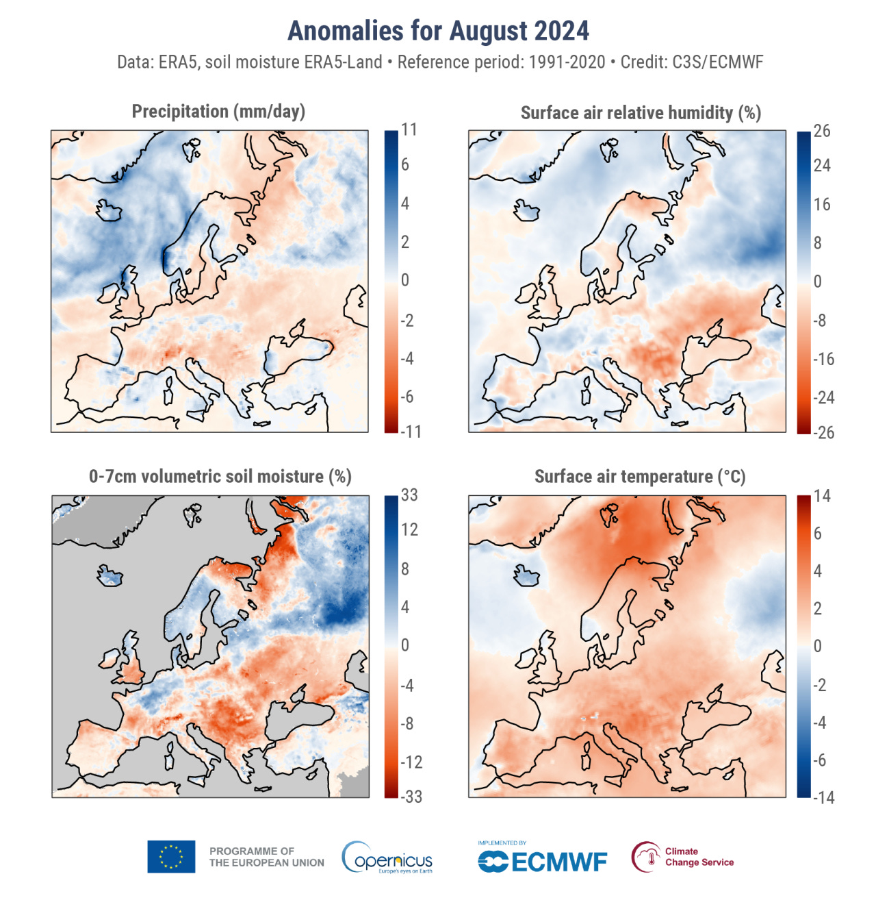
The Copernicus Climate Change Service's (C3S) monthly climate bulletin is out [link]
"August 2024 was drier than average over most of continental Europe including southern UK and Ireland, the Alps, the Balkans, northwest Russia and eastern Fennoscandia, with areas in the south and east experiencing drought and wildfires."
You can find more here.
Interesting reads
How we’re using AI to help cities tackle extreme heat [link]
"Google Research is applying AI to satellite and aerial imagery to build a Heat Resilience tool, helping cities understand how to reduce surface temperatures through planting trees or using highly-reflective surfaces, like cool roofs."

The CAMS on Air: Boreal summer 2024 newsletter [link]
"This bulletin highlights some of the significant atmospheric composition-related events that took place during the boreal summer (June-July-August) of 2024."
Impact of Satellite Data Quality on EO-Derived Insights for Decision Making [link]
"FrontierSI released their latest report: “Impact of Satellite Data Quality on EO-Derived Insights for Decision Making”.
The report studies the potential impact of EO data calibration quality on decision-making in Australia through a case study of national impact.
Explore the results to understand the implications of poor data quality for EO data providers and users.
Read the full report here."
Podcasts
Impact AI Podcast - Foundation Models for Earth Observation with Hamed Alemohamad from Clark University [link]
"Tune in tto his episode of Impact AI, where Hamed Alemohammad, Associate Professor at Clark University and expert in geospatial analytics, explores the power of foundation models for Earth Observation (EO) data."
Upcoming Events
Tickets are now on sale for SatSummit Lisbon [link]
"Tickets are now available for you to attend SatSummit 2024 in Lisbon on November 18th and 19th."
Check out some recordings from SatSummit 2022 [link]


