Level-2 News

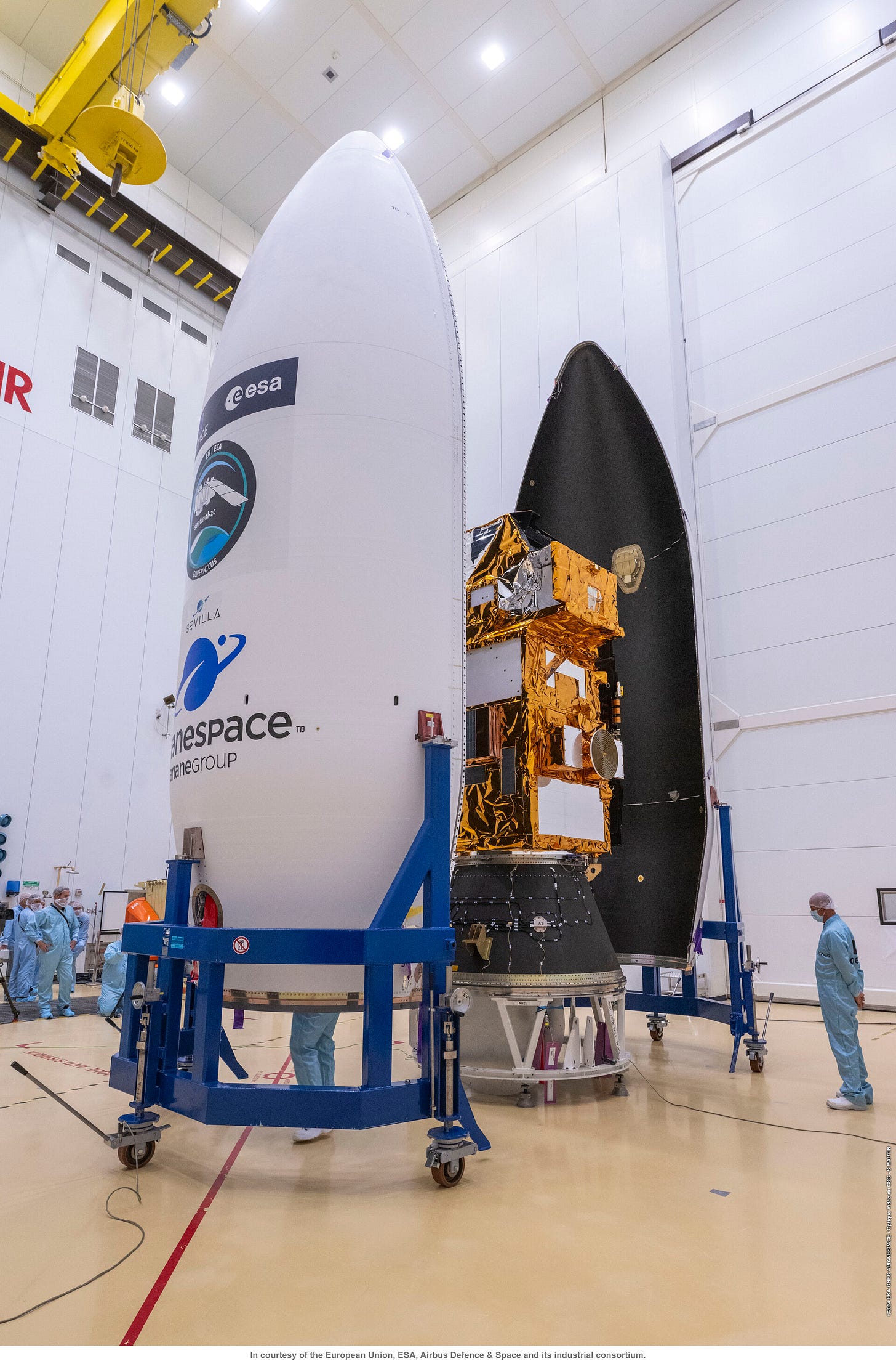
Sentinel-2C sealed in the Vega rocket fairing [link]
"As preparations continue to launch the Copernicus Sentinel-2C satellite on 4 September, the team at Europe’s Spaceport in Kourou, French Guiana, has bid farewell to their precious satellite as it was sealed from view within the Vega rocket fairing."
Planet signs deal with NATO to supply satellite imagery [link]
"Planet announced it has inked a deal with NATO to supply satellite imagery. The contract, signed with NATO’s Communications and Information Agency (NCIA), is set to provide the alliance with high-resolution data from Planet’s SkySat fleet as part of the Alliance Persistent Surveillance from Space (APSS) program."
Planet received first light data from their latest SuperDoves batch [link]
On Friday, August 16, Planet launched 36 SuperDoves into orbit on SpaceX's Transporter-11 Mission. On August 20, they received first light data.
Morocco Boosts Surveillance with Israeli Satellites [link]
Morocco has acquired two Synthetic Aperture Radar (SAR) satellites from Israel Aerospace Industries (IAI).
"The new satellites, known as Ofek 13 will provide Morocco with valuable data for a range of applications, including border security, disaster management, and land use planning."
EarthDaily Analytics Partners with Malaysian Mapping Specialist [link]
"EarthDaily Analytics announced a contract with MySpatial, a leading Malaysian geospatial mapping specialist servicing the government and private sectors.
The $1.7 million contract commenced in July 2024 and has an initial duration of four years.
Under the contract, MySpatial and its customers have immediate access to EDA’s current offering of high-quality Earth Observation data and scalable, AI-driven analytics."
Bayanat-Yahsat Launches UAE’s First SAR Satellite [link]
"Bayanat, an AI-powered geospatial solution provider, and Yahsat, the UAE’s satellite provider have announced the successful launch of the first LEO synthetic aperture radar (SAR) satellite. This initiative took place in partnership with ICEYE, a pioneer in SAR satellite operations for earth observation."
Mapbox Launches Data Support for Advanced Maps and Weather [link]
"Mapbox, a global leader in location technology, introduced new capabilities for its Mapbox Tiling Service (MTS) to efficiently process, style, and serve raster data from weather visualizations to custom satellite and aerial imagery.
The numerical information in NetCDF and GRIB raster data now persists from processing to rendering and can be styled for dynamic colourization creating visually stunning, interactive, and engaging weather maps."

Developer's Orbit
Code release of Aurora - a foundation model for atmospheric forecasting [link]
"Aurora is a machine learning model that can predict atmospheric variables, such as temperature. It is a foundation model, which means that it was first generally trained on a lot of data, and then can be adapted to specialised atmospheric forecasting tasks with relatively little data."
Related:
Awesome Weather Forecasting with Open-Source AI [link]
Check out this list of published AI weather models.
Clay Foundation Model - An open source AI model for Earth [link]
"Trained on 70 million satellite and aerial image chips of size 224x224px from all around the world, Clay v1 has a global perspective, statistically sampled and spanning from 2018 to 2023. Its diverse training set includes imagery from Landsat 8 and 9 (11 million chips), Sentinel 2 L2A (18 million), Sentinel 1 RTC (16 million), NAIP in the USA (20 million), and high-resolution LINZ data from New Zealand (3 million). Resolutions range from 30 meters to 30 centimeters. All fully open data."
Data
Aotearoa’s Coastal Change Dataset [link]
"This coastal change dataset for Aotearoa New Zealand provides nationwide coverage of coastal erosion and accretion patterns from the 1940s to present day."
Related:
Eroding New Zealand: New maps reveal where our coasts are crumbling fastest [link]
Introducing the AQI Hub [link]
"The AQI Hub is a comprehensive online resource dedicated to deepening the public's understanding of their own (Air Quality Indices) AQIs worldwide. The AQI Hub provides detailed descriptions of various national and regional AQI systems, enabling users to understand how an AQI is built and to compare and contrast how different countries assess and communicate air quality. By exploring the methodologies, scales, and health implications associated with each AQI, the AQI Hub empowers individuals to better interpret air quality data, fostering informed decisions about health and environmental protection."
Snapshots

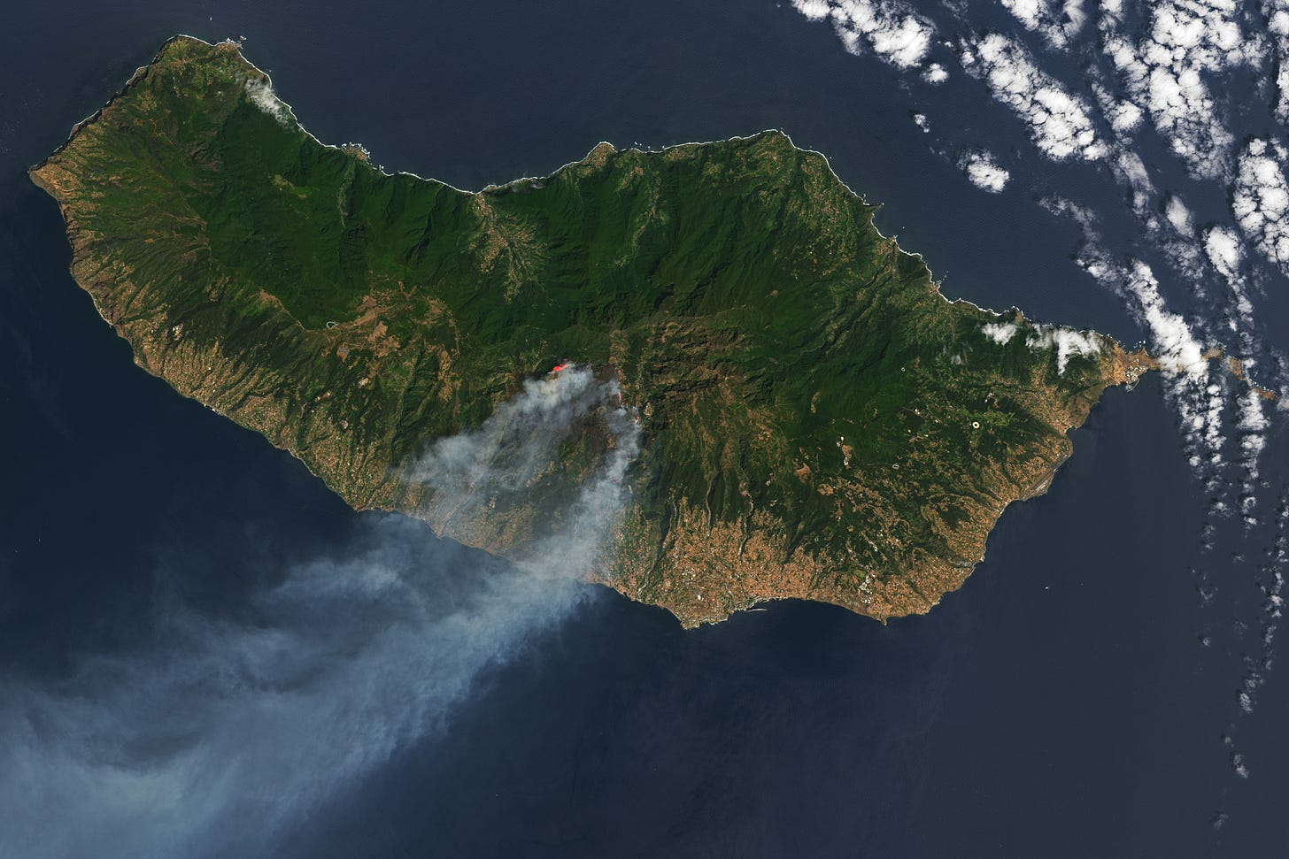
Smoke Streams from Fires in Madeira [link]
"In mid-August 2024, fires raged on Madeira, a Portuguese island 700 kilometers (430 miles) west of Morocco. As of August 20, the flames had burned more than 5,700 hectares of forest, according to the European Forest Fire Information System.
The blaze, which started in the mountains of Serra de Água on August 14, quickly spread east toward Curral das Freiras and Câmara de Lobos. When the OLI (Operational Land Imager) on Landsat 8 acquired these images on August 17, the fire was burning on three active fronts, and smoke streamed from the southern coast of the island over the Atlantic Ocean."
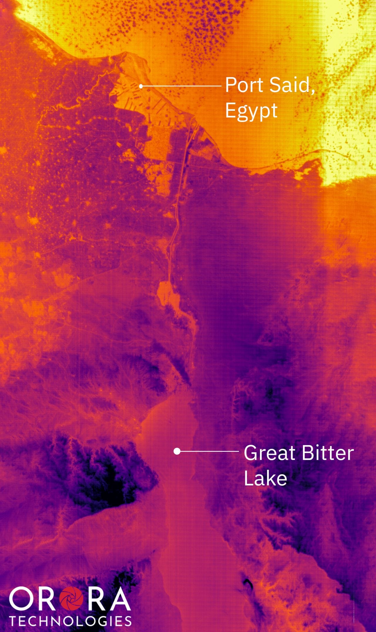
The Suez Canal [link]
"It’s hard to fully understand the impact that this small waterway has had on global development. This 205-meter (672-foot) wide canal is used by 15% of the world’s maritime trade, cutting about 7,000 kilometers (about 4,500 miles) off the journey from Asia to Europe - as long as there isn’t a ship wedged in the middle of it.
You can very clearly see how Port Said, with its hundreds of concrete streets and buildings, is much hotter than the surrounding desert, as heat is absorbed into these human structures. Because the depth of the canal is shallower than the Great Bitter Lake, you can clearly trace the lines of the canal itself, sometimes splitting into two separate lanes to accommodate two-way traffic.
One of the most interesting things to see is the difference in temperature between the Great Bitter Lake in the south and the warm Mediterranean in the north. While the two share a waterway with the canal, their temperatures differ by about 5-10 degrees Celsius between them (10-20 degrees Fahrenheit) at any given moment. The Mediterranean coast near Egypt tends to be much shallower and easier to heat than the Red Sea feeding the Great Bitter Lake, resulting in much cooler water."
Interesting reads
Segmenting Sandstorms in Satellite Imagery [link]
"Earth observation satellites allow us to observe these sandstorms in near-real-time, but existing detection algorithms fall short of providing fine-grained segmentation masks and do not always distinguish between dust and other kinds of aerosols."
Follow this post to learn how people at Element84 trained a deep learning model to segment sandstorms in satellite imagery.
Reflections on Leading NASA's IMPACT Project [link]
Check out this reflection by Rahul Ramachandran, the founding manager of NASA's Interagency Implementation and Advanced Concepts Team (IMPACT), as he looks back on five years of achievements with the Earth Science Data Systems Program.
One of IMPACT's success stories is the Harmonized Landsat and Sentinel-2 (HLS) project [link]
How the EU Space Programme supports conservation efforts [link]
"Conservation is crucial to maintaining biodiversity—an essential component of healthy ecosystems which provide essential services to humanity, such as clean air and water, pollination of crops, and climate regulation.
This week's Observer is looking at how the EU's Space Programme is supporting conservation efforts across Europe and beyond, either by providing data products to institutions or by supporting researchers and conservationists working on the ground to protect endangered species."
LinkedIn Highlights
"They want Nuggets!" By Leo Wang [link]
Follow Leo Wang's rant on LinkedIn (and the brilliant comment section) about identifying the true customers of satellite imagery (and more importantly, who is NOT).
Geospatial use cases for agriculture are growing, but the skills for these challenges go beyond your typical geospatial skillset [link]
Take a look at Matt Forrest's LinkedIn post discussing the diverse skill set required for developing geospatial solutions that go beyond your typical geospatial expertise, from deep learning to data engineering and managing cloud infrastructure.
What happens to the near-surface atmosphere if you put a colder surface next to a warmer one? [link]
"What happens to the near-surface atmosphere if you put a colder surface next to a warmer one? Air starts circulating and convection happens over the warmer patch. We see this phenomenon around irrigated fields in dry regions, in the surroundings of lakes, or over cities. These circulations are important for evaporation, cloud and precipitation formation, and pollutants transport, but even after years of research there is much to learn about them.
The simulation shows heat released (red is warm, blue cold) from the surface in a box of 6.4 km x 3.2 km. The left half is a cooler patch, comparable to an irrigated field, and the right half is a warmer patch."
Upcoming Events
ARSET - Introduction to Plankton, Aerosol, Cloud, Ocean Ecosystem (PACE) Hyperspectral Observations for Water Quality Monitoring [link]
"This three-part introductory training will provide an overview of past and current hyperspectral sensors. Specifically, the training will provide information on NASA’s PACE mission, its sensors and data products, webtools to access data, and software for processing hyperspectral data and water quality parameters derived from PACE/OCI.
The training will also highlight some advantages and limitations of PACE data. This will be the first ARSET training focusing on using hyperspectral data for water quality applications."
September 25, October 2, & October 9, 2024 | 10:00-11:30 EDT (UTC-4)
URBIS24 - URBan Insights from Space [link]
"The URBIS24 Workshop will gather a diverse community of urban policymakers, Earth Observation researchers, service providers and various end-users. Taking place at ESA/ESRIN in Frascati, Italy, during September 16–18, 2024, this event will offer an insightful exploration of urban challenges and innovative EO-integrated solutions."
Learning
Bridging the gap between Earth Engine and the Scientific Python Ecosystem [link]
"Talk on Bridging the gap between Earth Engine and the Scientific Python Ecosystem presented by Justin Braaten, Qiusheng Wu and Samapriya Roy."


