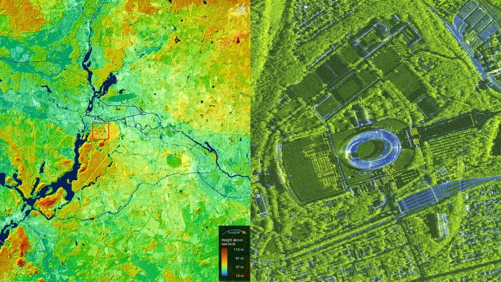
German radar satellites take a sharp look at European Championship stadiums [link]
"The 2024 European Football Championship kicked off in Germany on 14 June. The two radar satellites TerraSAR-X and TanDEM-X, operated by the German Aerospace Center (Deutsches Zentrum für Luft- und Raumfahrt; DLR), have focussed on the venues expressly for this event."
Level-2 News
Satellogic announces new round of layoffs [link]
"Weeks after cutting 13% of its workforce, imaging company Satellogic announced it is laying off an additional 70 employees and slowing deployment of new satellites.
In a filing with the U.S. Securities and Exchange Commission after markets closed June 14, Satellogic announced it was laying off about 70 employees, roughly 30% of its workforce. The company did not disclose details about the positions affected or in what locations."
Synspective Raises $44M in Series C Round [link]
"Synspective has secured another 7 billion yen ($44.1 million) in a Series C funding round. The Japanese synthetic aperture radar (SAR) satellite data and analytics solutions provider, will use the money to accelerate its global business expansion.
Earlier this year, the company launched its fourth SAR satellite, StriX-3, successfully reaching its target orbit. It aims to establish a constellation of 30 SAR satellites by the late 2020s, enabling the company to observe changes anywhere on Earth."
Ursa Space partners with Japan’s NEC to deliver SAR data insights [link]
"Ursa Space Systems, a provider of satellite-derived intelligence, announced a new partnership with NEC Corporation, a Japanese multinational information technology and electronics firm, to offer data services in Japan utilizing synthetic aperture radar (SAR) imagery."
Equitable Earth Coalition Partners with Chloris Geospatial in Digital Monitoring [link]
"The Equitable Earth Coalition announced a partnership with Chloris Geospatial as its exclusive provider of digital monitoring, reporting and verification (dMRV) of forest carbon data for its new forest carbon standard.
This partnership will allow projects verified with Equitable Earth to report more accurately than was previously possible – including the reporting of carbon emissions from deforestation as well as degradation and removals from carbon stock improvement."
NASA Selects Raytheon Company to Build Landsat Next Instruments [link]
"NASA selects Raytheon Company to provide three instruments and related services, with an option for one additional instrument, in support of the Landsat Next mission based at NASA’s Goddard Space Flight Center in Greenbelt, Maryland.
The contract includes a cost-plus-award-fee base period and a cost-plus-fixed-fee option period with a total value of $506.7 million."
NASA Selects Lockheed Martin to Build Next-Gen Spacecraft for NOAA [link]
"NASA, on behalf of the National Oceanic and Atmospheric Administration (NOAA), has selected Lockheed Martin Corp. of Littleton, Colorado, to build the spacecraft for NOAA’s Geostationary Extended Observations (GeoXO) satellite program.
This cost-plus-award-fee contract is valued at approximately $2.27 billion. It includes the development of three spacecraft as well as four options for additional spacecraft. The anticipated period of performance for this contract includes support for 10 years of on-orbit operations and five years of on-orbit storage, for a total of 15 years for each spacecraft."
LandsatNext – EOC receives next generation data [link]
"On the occasion of a visit by the United States Geological Survey (USGS) to Oberpfaffenhofen on June 7, 2024 DFD Director Prof. Stefan Dech and USGS Deputy Director Cynthia Lodge signed a cooperation agreement on the reception and use of next generation of US Landsat satellite data."
NASA Leader Emphasizes Satellite Data and Collaboration to Combat Climate Change [link]
"NASA wants to play a key role alongside the commercial satellite industry to use satellite technology to help avert the climate crisis. In a recent keynote at the Earth Observation Summit in London, Dalia Kirschbaum, director of the Earth Science Division, NASA Goddard Space Flight Center, said that NASA wants to help create an integrated system of data and make that available to others to address the climate crisis."
First General Assembly of the Copernicus Land Monitoring Service - Six Takeaways Unveiled [link]
"The Copernicus Land Monitoring Service (CLMS) had an exciting start to the month, celebrating its first General Assembly from June 3-5 in Antwerp, Belgium. This hybrid event brought together over 300 participants — including scientists, policymakers, and industry professionals — to shape the future of CLMS."
Developer's Orbit
Satellites Spotting Ships [link]
Follow this post by Mark Litwintschik where he trained a ship detection model that works on Umbra's SAR imagery. He used Ultralytics' YOLOv5 and the High-Resolution SAR Images Dataset (HRSID) for training the model.
Compute Sentinel-2 Level-2F and Level-2H Products [link]
"OpenEO now supports the computation of Sentinel-2 Level-2F and Level-2H products. The harmonization/fusion process includes upscaling Landsat data to match the resolution of Sentinel-2 data. This enhancement opens up new possibilities for remote sensing applications."
Data
New Copernicus ground motion data available on GEP [link]
"The Geohazards Exploitation Platform (GEP) is the outcome of an ESA initiative to implement Thematic Exploitation Platforms, i.e. advanced on-line processing environments dedicated to user communities in specific thematic areas. The GEP is looking at geological and hydrogeological hazards with a focus on terrain motion mapping. In the context of its current evolution, the GEP now provides access to a new collection of products: the Copernicus European Ground Motion Service (EGMS) Ortho Vertical (Level 3) covering the period from 2018 to 2022. The Copernicus EGMS provides valuable insights into ground movement across Europe, helping us better understand and manage risks associated with earthquakes, volcanoes, landslides, and land subsidence."
Snapshots
Summer Solstice 2024 [link]
"Summer officially begins in the Northern Hemisphere 20 June, marking the longest day of the year.
During the summer solstice, the Northern Hemisphere experiences the longest period of sunlight in a day or the longest day of the year."
"This animation shows one image per day captured by the Meteosat Second Generation from 20 June 2023 until 19 June 2024 captured at approximately 16:30 BST/17:30 CEST."
Peek-a-Bloom in the North Atlantic [link]
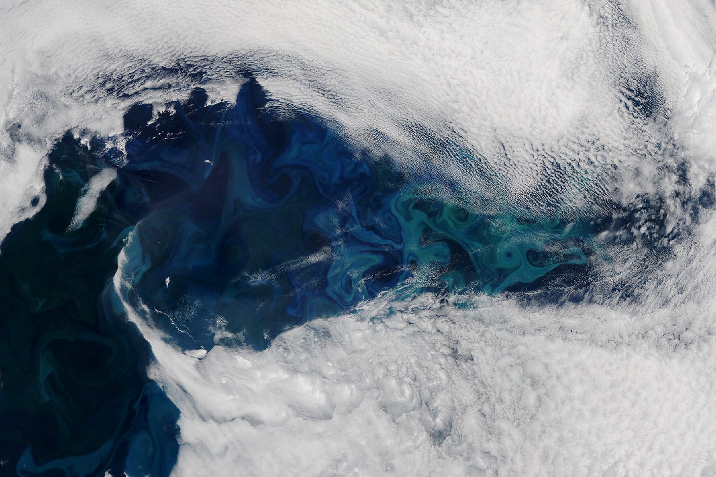
"Since May 2024, satellite images have hinted at a phytoplankton bloom developing off the coast of southeast Greenland. But a near-constant stream of clouds prevented optical sensors from getting a clear look. That changed in mid-June, when a short-lived gap in the clouds over the North Atlantic Ocean exposed the bloom’s colorful swirls.
The bloom is visible in this image, acquired on June 16, 2024, with the MODIS (Moderate Resolution Imaging Spectroradiometer) on NASA’s Aqua satellite. The image shows an approximately 800-kilometer-wide patch of the North Atlantic Ocean centered east of Greenland and south of Iceland. The bloom stretches many more hundreds of kilometers beyond the edges of this image."
NASA satellite returns image of sea ice swirls [link]
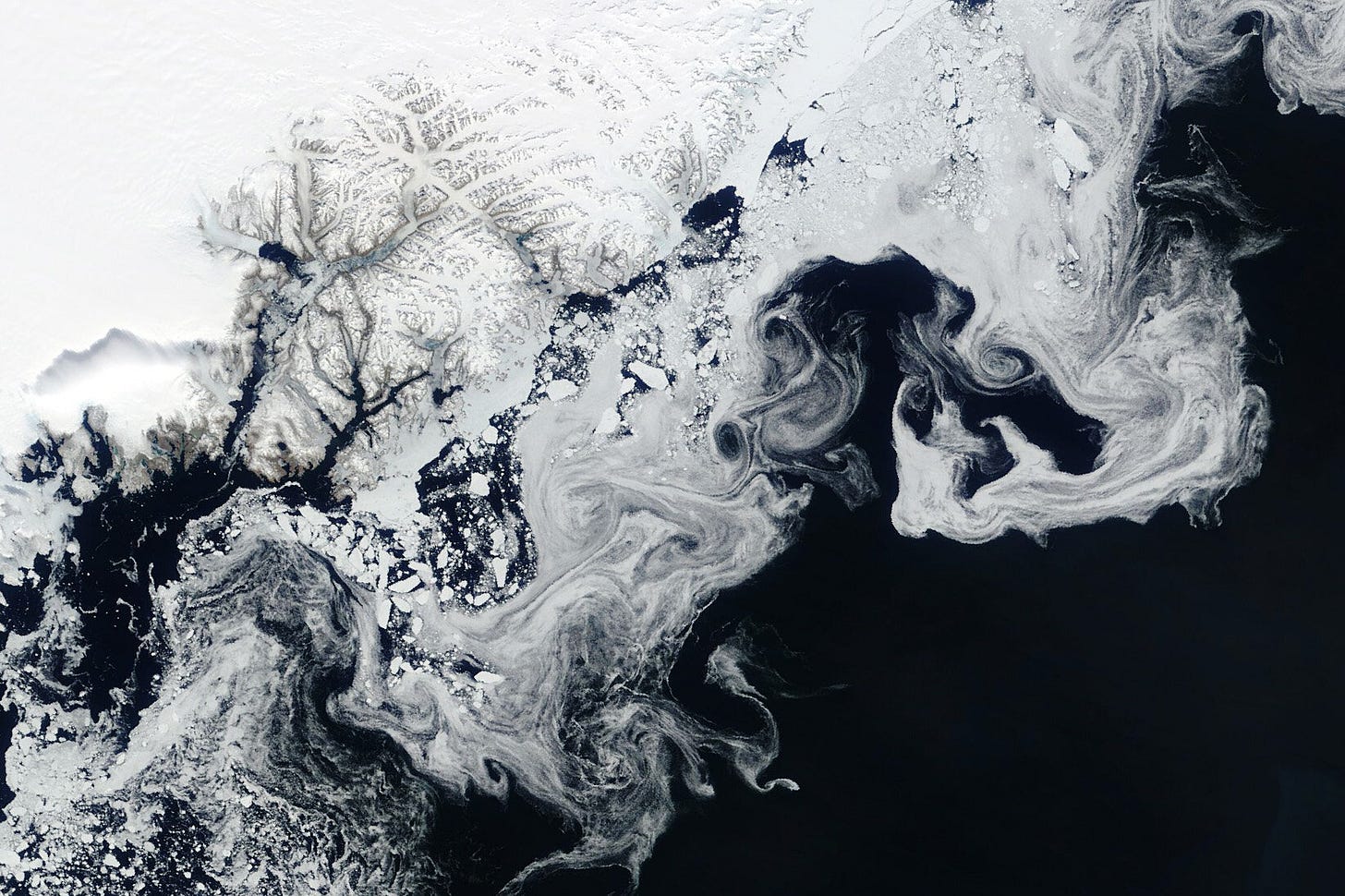
"NASA's Terra satellite captured floating fragments of sea ice as ocean currents carried them south along Greenland's east coast on June 4, 2024.
This ice traveled from the Fram Strait, a 450-kilometer (280-mile)-wide passage between Greenland and Svalbard, to the Arctic Ocean. Along the journey, it breaks into smaller pieces and starts to melt in warmer ocean waters, creating the wispy patterns seen in the image."
Interesting reads
Methane plumes mapping with multispectral and hyperspectral high-resolution data [link]
"Methane emissions from fossil fuel production are a major component of the anthropogenic methane emission budget. Emissions from this sector often occur as strong plumes from so-called point sources, which include infrastructure elements such as flares, compressor stations, storage tanks, or mine vents. Satellite remote sensing represents a key technology for systematic monitoring of methane emissions from such point sources around the world.
Typically, the detection of methane emissions relies on Copernicus Sentinel-5P, which provides a daily global map of methane concentration at a coarse 7×5.5 km resolution. Nonetheless, recently scientists have been exploring the use of higher resolution data to allow localising and quantifying emissions accurately besides detecting the presence of methane."
NASA Satellites Find Snow Didn’t Offset Southwest US Groundwater Loss [link]
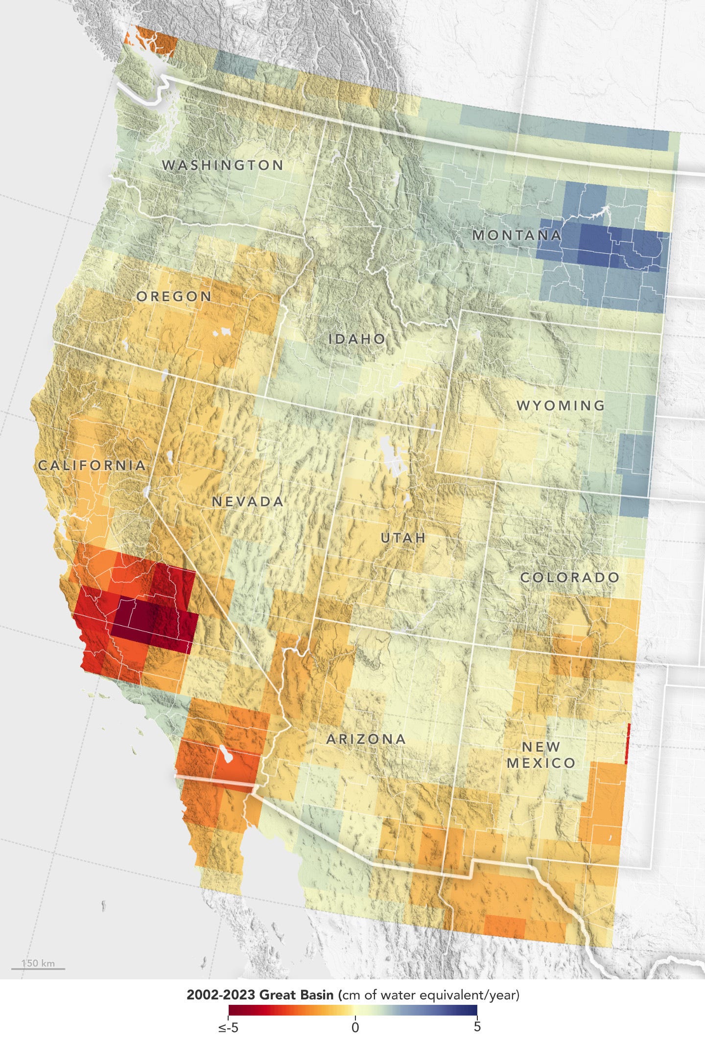
"Record snowfall in recent years has not been enough to offset long-term drying conditions and increasing groundwater demands in the U.S. Southwest, according to a new analysis of NASA satellite data.
Declining water levels in the Great Salt Lake and Lake Mead have been testaments to a megadrought afflicting western North America since 2000. But surface water only accounts for a fraction of the Great Basin watershed that covers most of Nevada and large portions of California, Utah, and Oregon. Far more of the region’s water is underground. That has historically made it difficult to track the impact of droughts on the overall water content of the Great Basin.
A new look at 20 years of data from the Gravity Recovery and Climate Experiment (GRACE) series of satellites shows that the decline in groundwater in the Great Basin far exceeds stark surface water losses. Over about the past two decades, the underground water supply in the basin has fallen by 16.5 cubic miles (68.7 cubic kilometers). That’s roughly two-thirds as much water as the entire state of California uses in a year and about six times the total volume of water that was left in Lake Mead, the nation’s largest reservoir, at the end of 2023."
When in drought: Researchers map which parts of the Amazon are most vulnerable to climate change [link]
"In the late 2000s, Scott Saleska noticed something strange going on in the Amazon rainforest. In 2005, a massive drought struck the region. Two years later, Saleska—a University of Arizona professor in the Department of Ecology and Evolutionary Biology—published surprising research that used satellite images to find that the drought resulted in more green growth in large swaths of the Amazon. On the other hand, field researchers saw plants turn brown and some die in response to the drought.
New research published in the journal Nature reveals what caused the scientific mismatch."
The researchers found that "different regions of the Amazon rainforest respond to drought differently because of differences in local forest environments and differences in the properties of trees themselves. This work goes beyond wide-scale climate factors and homes in on how local environments drive drought response."
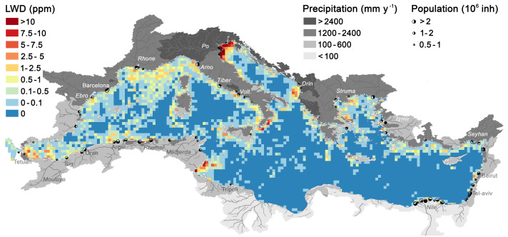
Surveilling marine litter from space becomes reality [link]
"In a work published today in Nature Communications, a group of international researchers, including JRC, established that accumulation patches of floating litter (also called windrows) can be identified in images taken by Copernicus satellites. By automatically analysing more than 300 000 remote sensing images of the Mediterranean Sea, researchers identified thousands of litter windrows. This new analysis made it possible to detect the most polluted areas, determine seasonal variability patterns and the extent of land-based emissions.
The team discovered thousands of litter windrows, ranging from a few hundred metres to 20 kilometres long. They then matched these findings with model data on the hydrological conditions in the Mediterranean Sea, provided by the JRC, which helped explain the distribution and accumulation patterns of the litter detected. This allowed the team to create the most detailed map of marine litter pollution to date."
A Year of Monthly Temperature Records [link]
"May 2024 was the warmest May on the books, marking a year of record-breaking monthly temperatures. Globally, average temperatures for the last 12 months hit record highs for each respective month – an unprecedented streak.
Dr. Kate Calvin, NASA's Chief Scientist and Senior Climate Advisor, answers some of the top questions pertaining to these temperature records and our changing climate."
LinkedIn Highlights
"Why isn’t everyone offering data under CC BY 4.0?" [link]
Follow one more post by Joe Morrison, VP of Remote Sensing at Umbra Space. This time, he writes about data lisences…
"I have seen other companies brag about releasing open data for disaster response purposes under licenses more restrictive than ours…why is it illegal to use it for commercial purposes? What’s the worst that can happen? Someone trains a commercial flood inundation model on your donated data and uses it to stand up a new commercial service? That doesn’t sound too bad…"


