

Level-2 News

EarthCARE is launched [link]
"ESA’s EarthCARE mission has completed its important ‘Launch and Early Orbit Phase’ and is ready to begin the commissioning of its four scientific instruments. The data they gather will improve our understanding of the role that clouds and aerosols play in Earth’s radiation balance and benefit both climate modelling and weather forecasting.
"EarthCARE launched at 00:20 CEST on 29 May on a SpaceX Falcon 9 rocket from Vandenberg Space Force Base in California, USA."
Tanager-1 Is Ready For Launch: Planet’s First Hyperspectral Satellite [link]
"Planet’s first hyperspectral satellite, Tanager-1—made possible by the Carbon Mapper Coalition and its philanthropic partners—is ready for launch. The spacecraft arrived at Vandenberg Space Force Base on June 3rd in preparation for liftoff as early as July on board the Transporter-11 Rideshare mission with SpaceX. Tanager-1 will be the first of a next-generation hyperspectral fleet which will expand Planet’s imaging capabilities in the spectral domain to complement the existing imaging capabilities in the temporal and spatial domains offered by the PlanetScope, SkySat, and Pelican missions."
ISRO working on mission to advance high-resolution thermal imaging for climate, resource management [link]
"The TRISHNA mission, a collaborative endeavour between ISRO and French space agency CNES, is engineered to deliver high spatial and high temporal resolution monitoring of Earth's surface temperature, emissivity, biophysical and radiation variables for surface energy budgeting at regional to global scale, according to the Indian space agency. The TRISHNA ((Thermal Infra-Red Imaging Satellite for High-resolution Natural Resource Assessment) mission addresses critical water and food security challenges, focusing on the impacts of human-induced climate change and efficient water resource management through evapotranspiration monitoring, ISRO said in statement on the occasion of the World Environment Day."
NOAA Taps BAE Systems to Measure Hyperspectral Ocean Color [link]
"The US’ central weather-tracking agency has commissioned BAE Systems to build an instrument for its next-generation weather and climate constellation, GeoXO.
Under the contract, BAE Systems will build a hyperspectral imager that will be fine-tuned to observe the Great Lakes and the US coastal regions. The company is now contracted to provide all three of the hyperspectral instruments for the GeoXO program."
Open Cosmos To Build Greece’s First EO Constellation [link]
"UK satellite manufacturer Open Cosmos will build a €60M ($65.1M) EO constellation for Greece to help the Mediterranean nation tackle ocean pollution and challenges in agriculture.
The constellation of optical satellites will be Greece’s first larger-scale satellite project dedicated to environmental monitoring.
The constellation will include seven small satellites in LEO, each fitted with multispectral and hyperspectral cameras for high-resolution Earth imaging. The constellation will help Greece to monitor the spread of marine pollution and provide farmers precision data to make agriculture more efficient."
NASA Launches Second Small Climate Satellite to Study Earth’s Poles [link]
"The second of NASA’s PREFIRE (Polar Radiant Energy in the Far-InfraRed Experiment) two satellites is communicating with ground controllers after launching on Wednesday, June 4. Data from these two shoebox-size cube satellites, or CubeSats, will better predict how Earth’s ice, seas, and weather will change in a warming world — providing information to help humanity thrive on our changing planet.
The CubeSat launched on top Rocket Lab’s Electron rocket from the company’s Launch Complex 1 in Māhia, New Zealand, and follows the May 25 launch of the first PREFIRE CubeSat. After a 30-day checkout period, when engineers and scientists confirm both CubeSats are operating normally, the mission is expected to operate for 10 months."
Satellogic lays off 13% of workforce [link]
"Satellogic has laid off 13% of its workforce as the company continues its efforts to reduce costs and seek new business from the U.S. government.
In a May 24 filing with the U.S. Securities and Exchange Commission, Satellogic announced it had laid off 34 employees, or about 13% of its workforce at the time. The company said the layoffs were part of its “previously announced and ongoing efforts to reduce operational costs and control spending.”
The latest layoffs come after earlier workforce reductions that cut about 110 jobs in 2023."
BlackSky Secures $7M Government Contract Renewal for Spectra Analytics Platform [link]
"BlackSky Technology inked a $7 million contract renewal with one of its existing international government customers on Friday to continue providing satellite monitoring services. BlackSky did not name the customer in the announcement.
BlackSky said the contract extension will give the customer the ability to continue drawing from multiple intelligence sources through the BlackSky Spectra tasking and analytics platform and extended direct access to its proprietary high-resolution, electro-optical constellation, as well as imagery and data from its partner constellations."
Air-quality mission ready to join its host weather satellite [link]
"Following months of meticulous testing to ensure that it will deliver first-class data on air quality around the world, the new Copernicus Sentinel-5 instrument has been delivered to Airbus in France ready to be installed on the first MetOp Second Generation weather satellite.
While not a satellite in the traditional sense, Sentinel-5 is a Copernicus mission that will be carried on the MetOp Second Generation A-type weather satellites, the first of which is expected to be launched in 2025.
Sentinel-5 follows on from the highly successful Sentinel-5 Precursor satellite, that has delivered a wealth of information on air-quality since it was launched in 2017."
Data
NASA’s TEMPO Instrument Air Quality Data Now Publicly Available [link]
"Air pollution data on a neighborhood scale are now available in near real-time from NASA's Atmospheric Science Data Center (ASDC) at Langley Research Center in Hampton, Virginia. The data come from NASA’s TEMPO instrument (Tropospheric Emissions: Monitoring of Pollution), which gathers hourly daytime scans of the atmosphere over North America from the Atlantic Ocean to the Pacific Coast and from roughly Mexico City to central Canada. The instrument is an advanced spectrometer that detects pollution by observing how sunlight is absorbed and scattered by gases and particles in the troposphere, the lowest layer of Earth’s atmosphere."
Related:
TEMPO V03 betal level 1, 2, and 3 product release [link]
Snapshots
Earth from Space: Madagascar jellyfish [link]
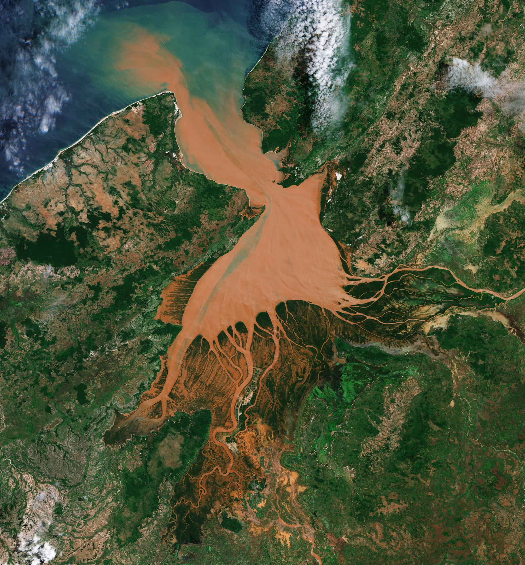
"Located in the Indian Ocean off the east coast of Africa and covering almost 600 000 sq km, Madagascar is the fourth largest island in the world.
The Mahajamba Bay, also known as Helodrano Mahajambe, lies in northwest Madagascar at the confluence of two major rivers: the Mahajamba entering from the south and the Sofia River flowing from northeast. Both rivers then empty into the Mozambique Channel, which separates Madagascar from the African continent."
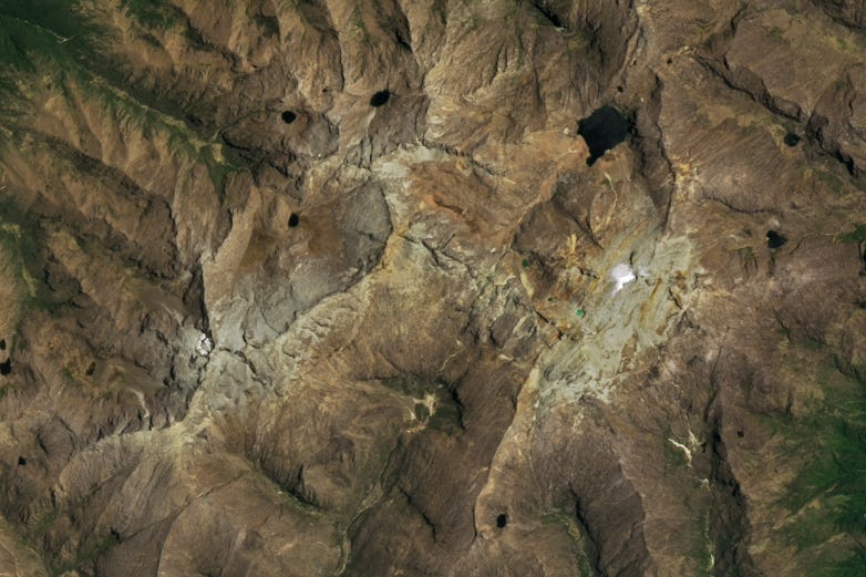
Humboldt Glacier’s Demise [link]
"Venezuela’s Humboldt Glacier has met its demise. The loss is the latest blow to our planet’s dwindling tropical glaciers, which have been shrinking and disappearing as temperatures have warmed.
Humboldt Glacier has long been perched high in the Sierra Nevada de Mérida, a range in the northern extent of South America’s Andes Mountains. In 2015, scientists estimated that this glacier spanned about 0.1 square kilometers (25 acres). By 2024, the ice area had shrunk to cover approximately one-tenth of that. Although there is no universally accepted size criterion defining a glacier, scientists generally agree that an ice field of this size is stagnant, meaning it is too small to flow downslope under the pressure of its own weight. By that definition, Venezuela is now glacier-free and the first postglacial nation in the Andes."
Interesting reads

Return Of The GEDI: Scanning The Amazon With Lasers [link]
"NASA has just extended the GEDI mission (pronounced Jedi, like the characters in “Star Wars”) which, after a year in hibernation, became operational at the end of April. Its powerful instrument shoots laser beams down from space to scan nearly all of the tropical and temperate rainforests on Earth, including the largest of all of them, the Amazon, which currently stores 17% of the world’s carbon stock.
Measurements taken from the forest scans allow researchers to form detailed, three-dimensional maps and calculate the amount of carbon those millions of trees store. This information is critical to determine the health of rainforests and, in turn, understand how much they are helping slow climate change by absorbing CO2. It’s also critical for the burgeoning carbon-offset markets. Reflecting this growing interest, the GEDI mission has just been extended until 2030."
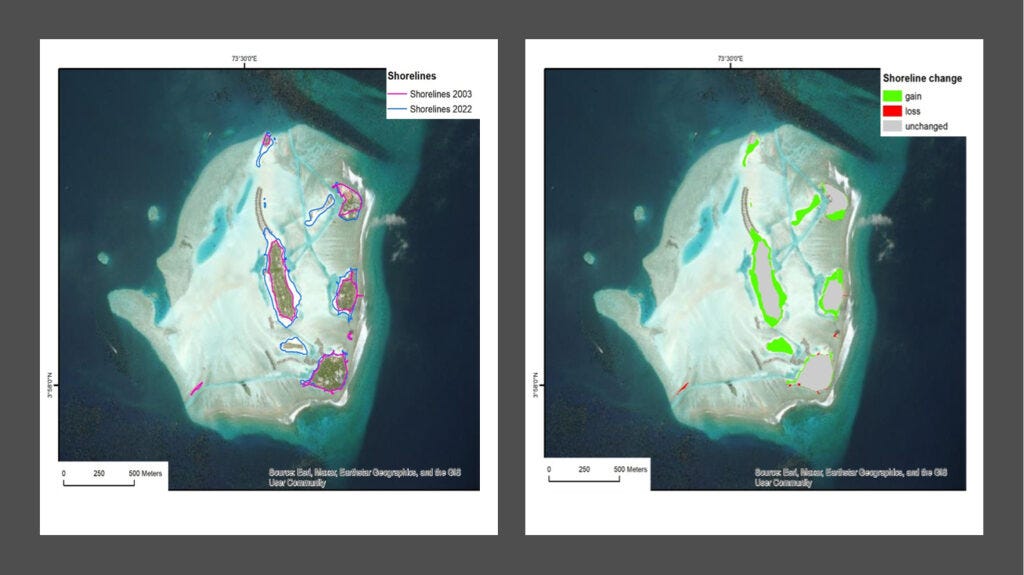
Web-based Application for Historical Data of Coastal Vulnerability Indices in Maldives Region [link]
"In the Indian Ocean, there is a low-lying atoll island nation comprising approximately 1.200 islands, with 187 of them being currently inhabited. Given the limited land resources and high population densities, monitoring coastal vulnerability is a primary concern for the Maldivian Ministry of Environment, Climate Change, and Technology. One of the key responsibilities of the Maldivian government is to maintain a historical geospatial database for relevant coastal vulnerability indices.
To meet this requirement, the dedicated marine domain activity underESA Global Development Assistance (GDA), in partnership with the World Bank (WB), applied Earth Observation (EO) resources suitable for assessing the effects of climate change on different sectors related to the Blue Economy and the marine environment. This initiative aimed to empower stakeholders, policymakers, and researchers to make well-informed decisions about regional investments and endeavours, with a strong emphasis on environmental concerns."
Copernicus data supports Member State compliance with EU air quality regulations [link]
"The European Union is paving the way towards adopting one of the world’s most ambitious air quality regulations. The revision of the Ambient Air Quality Directives is moving forward, and Member States will have to set strict monitoring and evaluation standards. The new Directives explicitly mention Copernicus, the Earth Observation component of the EU Space Programme, and particularly the Copernicus Atmosphere Monitoring Service (CAMS), as relevant tools to support Member States in their monitoring obligations."
Global temperature is likely to exceed 1.5°C above pre-industrial level temporarily in next 5 years [link]
"There is an 80 percent likelihood that the annual average global temperature will temporarily exceed 1.5°C above pre-industrial levels for at least one of the next five years, according to a new report from the World Meteorological Organization (WMO). This is a stark warning that we are getting ever closer to the goals set in the Paris Agreement on climate change, which refers to long-term temperature increases over decades, not over one to five years."
Upcoming Events
Use and interpret the European Ground Motion Service data [link]
"Breaking new ground in satellite Earth observation, the European Ground Motion Service (EGMS) provides free and open, millimetre-scale measurements of ground motion across the European continent. EGMS is relevant for everyone interested in geospatial sciences.
In this second webinar, we will demonstrate how to visualize and interpret EGMS data."
Very interesting news this week. The Return of the GEDI is good news for our planet, as I believe the Empire is indeed striking back.