

Level-2 News

Canada's wildfire season begins [link]
"Wildfire season has arrived in full force in Canada, prompting evacuation orders and alerts in several towns in British Columbia and Alberta due to the danger of uncontrolled blazes.
Hazardous smoke from the fires has also triggered air quality alerts in Canada and the northern US."
SatVu Plans Two New ‘Thermometer’ Sats After Failure [link]
"London-based SatVu is preparing to launch two temperature-taking satellites next year after losing its pathfinder mission in December.
In October, SatVu released the first images from HotSat-1, including short movies showing trains traveling on a main US rail line. The success, however, was short lived, ending two months later when the spacecraft’s cutting-edge infrared camera suffered a mission-ending anomaly."
Planet Extends its Digital Farming Contract with Germany’s BASF [link]
"German smart agriculture company BASF Digital Farming GmbH will expand the scope of its existing contract with Planet Labs in order to access more data from Planet’s Crop Biomass Planetary Variable analysis feed. In an announcement, BASF Digital Farming said it will increase its use of Planet’s satellite data products to power its own “Xarvio” digital farming products and services."
Marble Imaging and Reflex Aerospace to Deploy EO Satellite Network [link]
"Marble Imaging is teaming up with Reflex Aerospace to build a new Earth Observation (EO) constellation. Marble Imaging, based in Bremen, Germany, is planning a constellation of up to 200 small satellites. The initial satellite will be built for Marble Imaging by Reflex Aerospace with the funding coming via the German Space Agency at DLR. Marble Imaging won the agency’s small satellite payload competition, Kleinsatelliten Nutzlastwettbewerb. Marble Imaging announced its plans on May 10.
By developing Europe’s first EO VHR satellite constellation in partnership with Reflex, Marble said this challenges the U.S.-dominated market to strengthen European independence in the supply of VHR EO data."
Snapshots
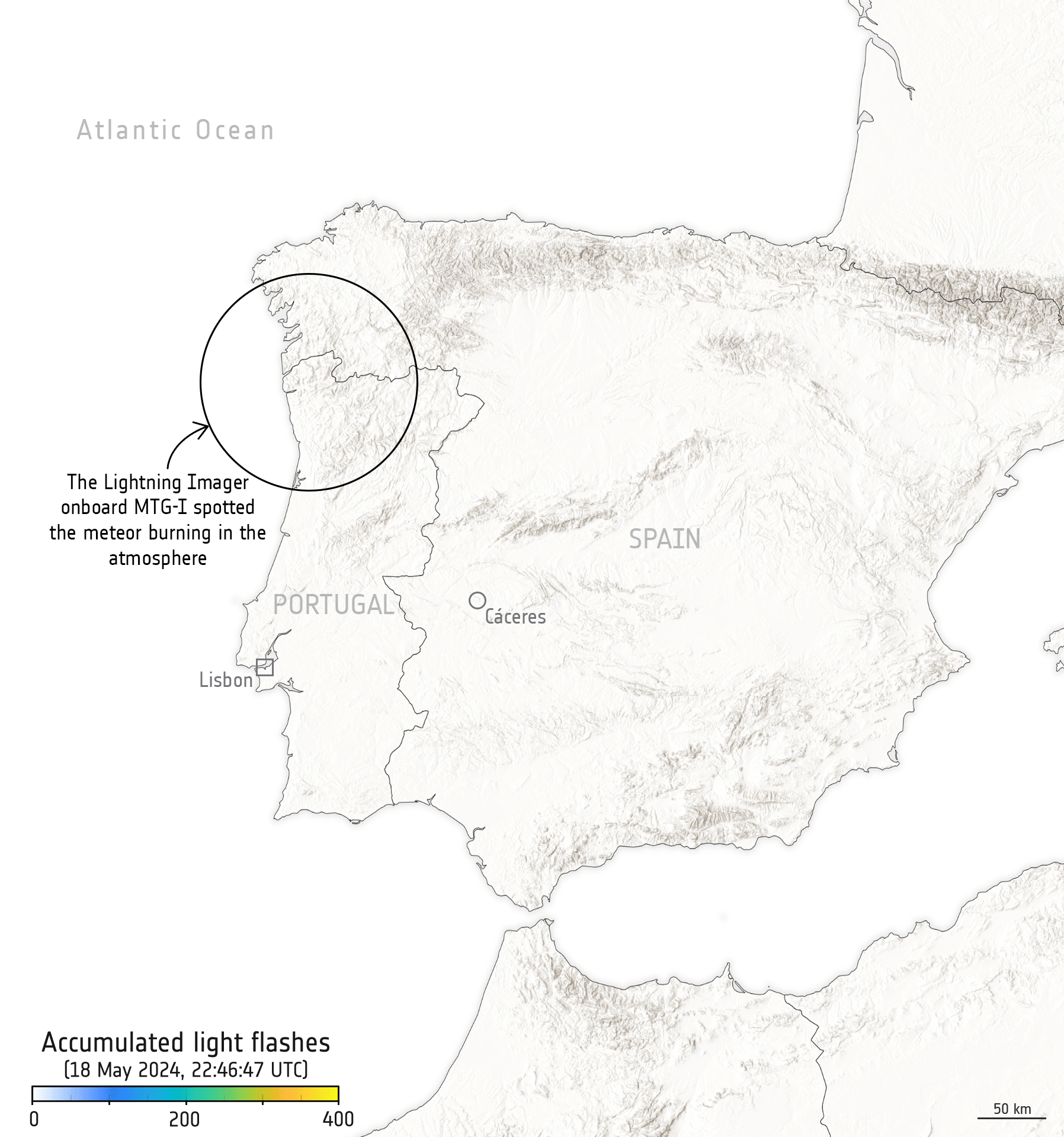
Fireball witnessed by weather satellite [link]
"While a meteor lit up the skies over Spain and Portugal recently, it was also captured by the Meteosat Third Generation Imager weather satellite hovering 36,000 km away in geostationary orbit."
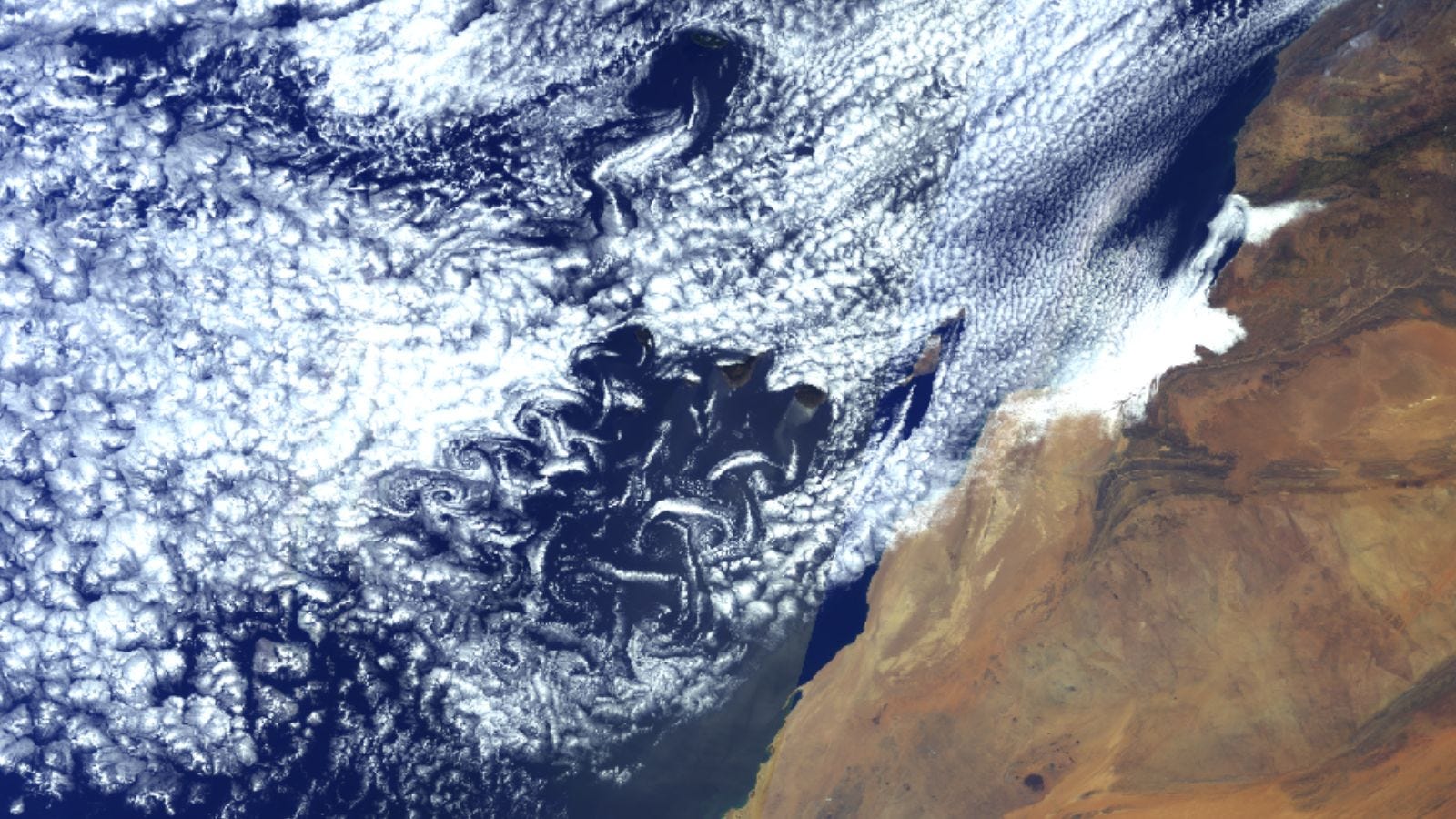
Kármán vortices spotted south-west of the Canary Islands [link]
"These swirly clouds, also known as von Kármán vortices, have been spotted south-west of the Canary Islands over the past few days.
The Copernicus Sentinel-3 satellite captured the impressive patterns from space on 13 May."
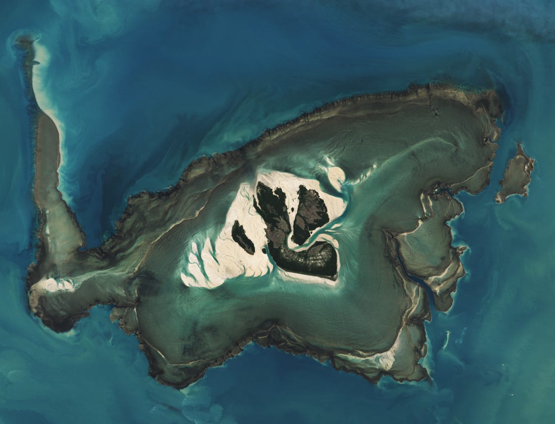
Montgomery Reef Revealed [link]
"The Kimberley coast of Western Australia has one of the largest tidal ranges in Australia and the world. At Montgomery Reef, in Collier Bay, water levels drop sharply at low tide, allowing the plateau-shaped reef to emerge several meters above the water level.
Tidal shifts are particularly noticeable in this area because of the flat, shelf-like terrain along the Kimberley coast.
When the tide rises, the sandy islets and main mangrove-covered island, Yawajaba, within Montgomery Reef are visible, but the reef is mostly underwater and out of view. During low tides, the water level can drop by as much as 10 meters (33 feet), revealing the expansive terraced structure of the reef and the network of shallow lagoons surrounding Yawajaba."
Interesting reads

How ‘Glowing’ Plants Could Help Scientists Predict Flash Drought [link]
"An unusual boost in plant productivity can foreshadow severe soil water loss, and NASA satellites are following the clues.
Flaring up rapidly and with little warning, the drought that gripped much of the United States in the summer of 2012 was one of the most extensive the country had seen since the years-long Dust Bowl of the 1930s. The "flash drought," stoked by extreme heat that baked the moisture from soil and plants, led to widespread crop failure and economic losses costing more than $30 billion.
While archetypal droughts may develop over seasons, flash droughts are marked by rapid drying. They can take hold within weeks and are tough to predict. In a recent study published in Geophysical Research Letters, a team led by scientists from NASA's Jet Propulsion Laboratory in Southern California was able to detect signs of flash droughts up to three months before onset. In the future, such advance notice could aid mitigation efforts.
How did the team do it? By following the glow."
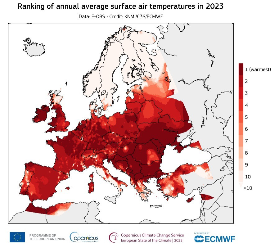
European State of the Climate (ESOTC) 2023 - Europe experienced an extraordinary year of extremes with record-breaking heatwaves, wildfires, floods, and drought [link]
"Since the 1980s, Europe has been warming twice as fast as the global average, becoming the fastest-warming continent. This is due to several factors, including the proportion of European land in the Arctic, which is the fastest-warming region on Earth. Europe’s fast warming is also caused by changes in atmospheric circulation which cause more frequent summer heatwaves. Glaciers are melting, and there are changes in the pattern of precipitation. An increase in extreme rainfall is leading to catastrophic events, such as the widespread flooding seen in Italy, Greece, Slovenia, Norway and Sweden in 2023. Meanwhile, southern Europe has suffered from widespread droughts and wildfires. Overall, the frequency and severity of extreme events is increasing. Estimates indicate economic losses from weather- and climate-related events in Europe reached €13.4 billion in 2023. Millions of people were affected, and at least 151 lives were lost in due to flooding, storms, and wildfires."
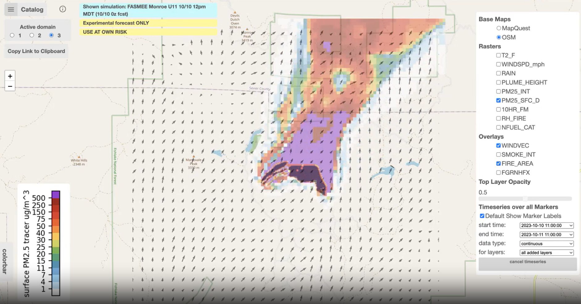
NASA's 'Wildfire Digital Twin' pioneers new AI models and streaming data techniques for forecasting fire and smoke [link]
"NASA's "Wildfire Digital Twin" project will equip firefighters and wildfire managers with a superior tool for monitoring wildfires and predicting harmful air pollution events and help researchers observe global wildfire trends more precisely.
The tool will use artificial intelligence and machine learning to forecast potential burn paths in real time, merging data from in situ, airborne, and spaceborne sensors to produce global models with high precision.
Whereas current global models describing the spread of wildfires and smoke have a spatial resolution of about 10 kilometers per pixel, the Wildfire Digital Twin would produce regional ensemble models with a spatial resolution of 10 to 30 meters per pixel, an improvement of two orders of magnitude."
5 Things to Know About NASA’s Tiny Twin Polar Satellites [link]
"Twin shoebox-size climate satellites will soon be studying two of the most remote regions on Earth: the Arctic and Antarctic. The NASA mission will measure the amount of heat the planet emits into space from these polar regions — information that’s key to understanding the balance of energy coming into and out of Earth and how that affects the planet’s climate.
The data from the Polar Radiant Energy in the Far-InfraRed Experiment (PREFIRE) mission will help improve our understanding of the greenhouse effect at the poles — specifically, the capacity of water vapor, clouds, and other elements of Earth’s atmosphere to trap heat and keep it from radiating into space. Researchers will use this information to update climate and ice models, which will lead to better predictions of how sea level, weather, and snow and ice cover are likely to change in a warming world."