Level-2 News
Privateer acquires Orbital Insight [link]
"Privateer acquired geospatial data analysis firm Orbital Insight in a deal announced May 6.
Privateer also raised $56.5 million in a Series A round first reported by Reuters."
BlackSky Reports $24.2M Revenue in Q1 2024 [link]
"BlackSky reported $24.2 million in revenue in the first quarter of 2024, up 32% from the same time last year. The company released its Q1 financials on May 8.
Imagery and software analytical services revenue is the largest portion of the company’s revenue — $17.8 million in the first quarter of 2024. This was an increase of 13% over the prior year period, driven by incremental customer orders for imagery services."
EO Could Add 3.8T to Global GDP—If Industry Embraces It [link]
"The analysis and use of EO data could add $700B each year to the global economy by 2030, up from $266B today.
That’s according to a report from the World Economic Forum, in collaboration with Deloitte, which estimates EO data could add $3.8T to global GDP between 2023 and 2030."
Muon Space and Earth Fire Alliance Introduce a New Wildfire Detection Satellite Constellation [link]
"Muon Space unveiled plans for its LEO FireSat Constellation, a wildfire management network the company is building with Earth Fire Alliance.
The constellation will leverage the Muon Halo spacecraft platform and incorporate multispectral infrared instruments. The group plans to launch its pathfinder satellite in 2025 and its first three birds in 2026."
ICEYE to allow customers to directly task the company’s imaging satellites [link]
"Iceye is providing customers with direct control to task their satellites, a capability that is increasingly common.
The direct tasking of satellites by customers is becoming an increasingly common capability offered by commercial remote sensing satellite companies, enabling users to dynamically adjust imaging priorities and respond to emerging events."
ICEYE Announces API for Accessing to World’s Largest SAR Satellite Constellation [link]
"ICEYE announced the launch of two new application programming interfaces (APIs) that will give customers faster access to imagery from the world’s largest SAR satellite constellation through a self-driven, automated process."
Capella Space Introduces Fully-Automated Vessel Classification [link]
"Capella Space announced the release of automated, AI-powered Vessel Classification for Capella Space’s high-resolution, synthetic aperture radar (SAR) imagery.
Vessel Classification is fully integrated with Capella’s secure tasking web application and API, enabling users to order the analytic at the same time they place a Tasking request.
Users can also order Vessel Classification on imagery available in Capella’s extensive historical archive for deeper time series analysis.
The Capella Space Vessel Classification offering streamlines analyst workflows by automating vessel detection and classification, so users know exactly where to look and what they are looking at in any image."
Descartes Labs Government Selects EarthDaily Analytics for EO data [link]
"Descartes Labs and its subsidiary, Descartes Labs Government, has selected EarthDaily Analytics as a supplier for their EO data to power their geospatial analytics and AI solutions.
The anticipated EarthDaily Constellation is set to launch later in 2024. Their “string of pearls” configuration will enable coverage of nearly 100% of the world’s land masses and maritime regions every six hours."
Introducing Themes and Highlights to the Copernicus Browser [link]
"Recently several themes have been added to the Copernicus Browser alongside the default theme. Themes in this context are collections of highlights, individual examples of satellite imagery from a specific time and date (aka. pins) with a specific visualization, together with a short explanation. By enabling themes we’ve made it even easier for earth observation rookies to find the best examples for the applications they’re most interested in."
Developer's Orbit

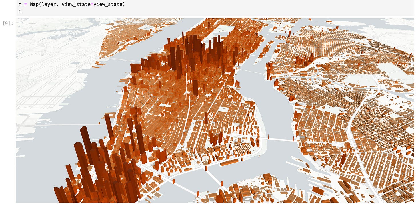
Lonboard 0.9 brings direct integration with DuckDB Spatial's Python API [link]
"In one line of code, visualize millions of geometries from a SQL query in a Jupyter Notebook. Powered by Apache Arrow and deck.gl under the hood."
Overture Maps Buildings [link]

Building Blocks for Modern Earth Observation [link]
"Last year, DevSeed announced eoAPI, a modern, cloud-native framework for EO data management. It is a set of software packages that rely on standards like Spatio Temporal Asset Catalog (STAC) to manage massive EO datasets for analysis and applications. Platforms built with eoAPI now manage over a billion STAC items, making them findable, accessible, interoperable, and reusable (FAIR)."
Snapshots

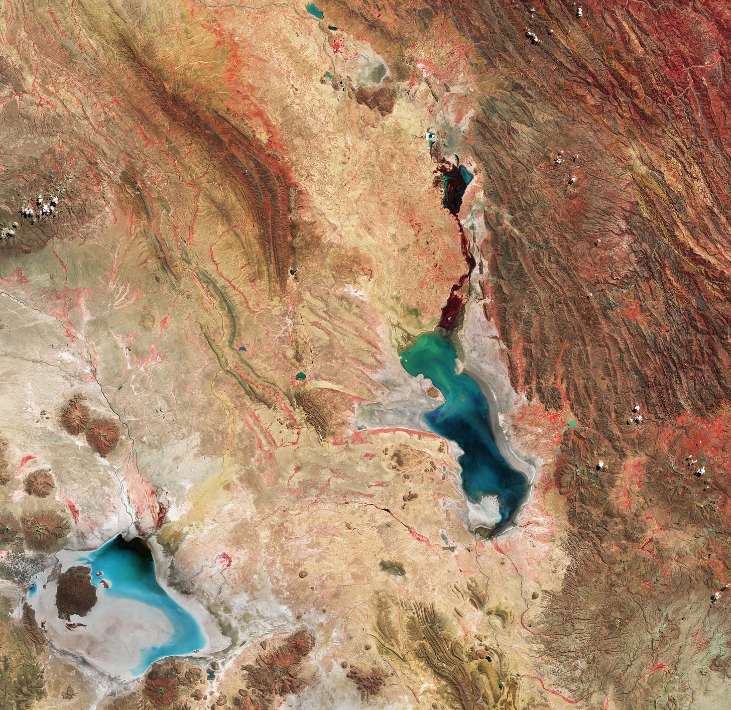
Earth from Space: Bolivian salt lakes [link]
"Some 40 000 years ago, this area was part of a giant lake that dried up, leaving behind two salt flats: Uyuni (not pictured) and Coipasa, visible in grey and light blue in the bottom-left corner. It also left behind two lakes: Poopó, the larger water body near the centre of the image, and Uru Uru, just above Poopó.
Lake Poopó is a saline lake and covers approximately 1000 sq km. It is an endorheic basin, which means water is lost through evaporation.
However, the lake’s shallow nature, with an average depth of just 3 m, has made its water level very sensitive to fluctuations. This is clear to see in the image, as part of the lakebed surrounding the water appears grey and dry. In the last decades, the lake has fully evaporated on some occasions, with catastrophic consequences for the region’s flora and fauna and for the economy."
Interesting reads
Natural Language Geocoding [link]
"In our increasingly data-driven world, the ability to quickly and accurately access geospatial data can transform industries from public health to urban planning. Imagine being able to locate and analyze data from ‘within 10 miles of the North Carolina coastline’ in mere seconds. Natural Language Geocoding makes this possible, bridging the gap between complex geospatial queries and user-friendly language."
The fast development of DestinE’s Climate Change Adaptation Digital Twin [link]
"The Climate Change Adaptation Digital Twin (Climate DT) developed in the Destination Earth initiative (DestinE) of the European Commission is a pioneering effort to build an operational and interactive capability for novel multi-decadal global climate projections with local granularity (at 5 to 10 km resolutions), providing information across scales that matter for decision-making in support of climate change adaptation.
Read this article for a brief overview of what has been achieved during the first phase of DestinE (December 2021 – 2024 June) and the key objectives of the Climate DT teams for the second phase of the initiative (June 2024 – June 2026)."
NASA Is Helping Protect Tigers, Jaguars, and Elephants. Here’s How. [link]
"As human populations grow, habitat loss threatens many creatures. Mapping wildlife habitat using satellites is a rapidly expanding area of ecology, and NASA satellites play a crucial role in these efforts. Tigers, jaguars, and elephants are a few of the vulnerable animals whose habitats NASA is helping track from space."
International SWOT Mission Can Improve Flood Prediction [link]
"Rivers, lakes, and reservoirs are like our planet’s arteries, carrying life-sustaining water in interconnected networks. When Earth’s water cycle runs too fast, flooding can result, threatening lives and property. That risk is increasing as climate change alters precipitation patterns and more people are living in flood-prone areas worldwide.
Scientists and water managers use many types of data to predict flooding. This year they have a new tool at their disposal: freshwater data from the Surface Water and Ocean Topography (SWOT) satellite. The observatory, a collaboration between NASA and the French space agency, CNES (Centre National d’Études Spatiales), is measuring the height of nearly all water surfaces on Earth. SWOT was designed to measure every major river wider than about 300 feet (100 meters), and preliminary results suggest it may be able to observe much smaller rivers."
AI in Earth observation: a force for good [link]
"The upcoming launch of the Φsat-2 mission is a prime example of the pioneering work that ESA does in the field of AI in Earth observation.
But when it comes to AI, hopes and fears abound in equal measure. In this interview, ESA’s Rochelle Schneider sets the record straight on how this transformational technology is improving access to crucial information on the state and future of our planet."
LinkedIn Highlights
This LinkedIn post (+ comment section) related to Aravind's recent deep dive [link]
Aravind's recent deep dive on satellite imagery platforms has sparked this thread on LinkedIn.
Related:
The State of Earth Observation Platforms [link]
This recent post by Joe Morrison about customer trust, market valuation and the challenges a satellite imagery company faces [link]
Upcoming Events
ESA Training Course on Arctic Methane and Permafrost 2024 – UNIS, Svalbard, Norway [link]
"The European Space Agency (ESA) is organising an Earth Observation (EO) training course in collaboration with the NASA Jet Propulsion Laboratory (JPL) and the Svalbard Integrated Arctic Earth Observing System, SIOS.
The course will take place from 9-14 September 2024 at the Svalbard Science Centre in Svalbard, Norway."
Registrations:
Applications are open from 01 May to 03 June 2024.
Registration link


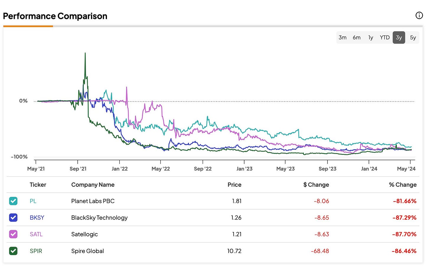
I'm still holding those Planet stocks hoping someday...