

Level-2 News
NASA’s CloudSat Ends Mission Peering Into the Heart of Clouds [link]
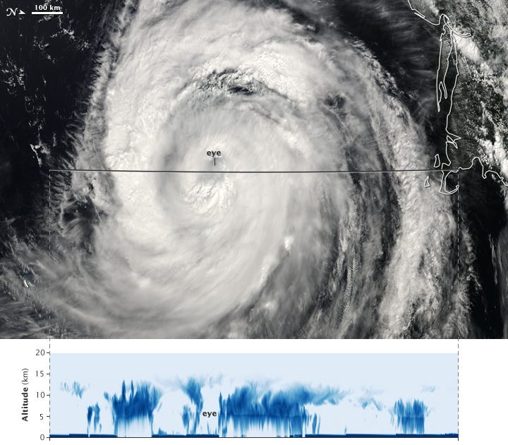
"CloudSat, a NASA mission that peered into hurricanes, tallied global snowfall rates, and achieved other weather and climate firsts, has ended its operations. Originally proposed as a 22-month mission, the spacecraft was recently decommissioned after almost 18 years observing the vertical structure and ice/water content of clouds.
When launched in 2006, the mission’s Cloud Profiling Radar was the first-ever 94 GHz wavelength (W-band) radar to fly in space. A thousand times more sensitive than typical ground-based weather radars, it yielded a new vision of clouds — not as flat images on a screen but as 3D slices of atmosphere bristling with ice and rain."
Maxar Closes in on the Launch of its WorldView Legion Satellites [link]
"Maxar is preparing to launch its first two WorldView Legion EO satellites aboard Falcon 9, following years of delays for the new constellation. The launch was slated for yesterday (April 25) but was pushed back without a determined date."
South Korea Initiates EO Constellation with NEONSAT-1 Launch [link]
"South Korea took the initial steps toward building its domestic EO capability on Tuesday with the launch of NEONSAT-1, the first in a planned 11-sat constellation.
The 100-kg nanosat launched aboard a Rocket Lab Electron rocket from the Mahia spaceport in New Zealand."
Satellogic Partners With O.N.E. Amazon to Build the 'Internet of Forests' [link]
"Satellogic, signed a letter of intent with O.N.E. Amazon to support the creation of an initiative called the 'Internet of Forests.'
Satellogic will look to support O.N.E. Amazon's Internet of Forests — a large-scale sensor network that will be used to monitor key variables within the Amazon rainforest."
GAF AG awarded contract for CAP-Area Monitoring 2024 in Bavaria [link]
"As part of the European Common Agricultural Policy (CAP), GAF AG has been awarded a multi-year framework contract for the automated analysis of satellite data for the monitoring of all agricultural areas in the German federal state of Bavaria. The contract runs for four years and covers the monitoring of numerous crop types as well as the evaluation of compliance with agri-environmental and climate protection measures using optical and radar data from the European Copernicus Sentinel Programme."
Data

NASA's Surface Water and Ocean Topography (SWOT) Mission Data Release [link]
"In March 2024, the SWOT mission team released a suite of pre-validated Level 1 and Level 2 hydrology and oceanography datasets offering terrestrial water surface elevation, slope, width, area, sea surface height, significant wave height and wind speed measurements, and more."
Read this article to learn more about these new datasets, a brief overview of the SWOT mission, how these data are acquired, and data applications.

High Resolution 1m Global Canopy Height Maps [link]
"Meta Sustainability Group and the World Resources Institute released a Global Canopy Height map at 1m resolution."
The dataset is already available in the Awesome gee-community-catalog.org. [link]
Related:
Using Artificial Intelligence to Map the Earth’s Forests [link]
Snapshots
A Blanket of Ash from Ruang [link]
"Ruang is a small volcanic island in the Sangihe Islands arc in North Sulawesi, Indonesia, that is home to about 800 people. Late on April 16, 2024, the mountain roared to life, unleashing a series of explosive eruptions that, at times, sent plumes of ash and gas billowing high into the stratosphere. The eruption also bombarded the island with tephra, small pebbles of lapilli, and fine shards of pulverized rock called ash."
Interesting reads

10 ways Earth is interconnected [link]
"Understanding the Earth system and the complex interactions that shape our planet is paramount for addressing environmental challenges, mitigating climate change, preparing for natural disasters, managing resources sustainably and conserving biodiversity.
Each component of the Earth system – from the atmosphere and oceans to land surfaces and ice sheets – influences and interacts with one another in complex ways.
Here are 10 examples of how Earth’s systems intertwine and how satellite measurements are key to understanding these complex processes."
Data-driven regional modelling [link]
Follow this post to learn more about limited-area modelling and data-driven approaches for regional weather forecasting.
The post introduces a framework called Anemoi, which is used to create the AIFS, but can also create data-driven weather forecasting models at regional or global scale.
"The authors will open source this toolbox soon, when it is sufficiently mature to allow easy use."
From space to soil [link]
"Soil sealing might not be a term that everyone's familiar with, but its effects are felt far and wide, particularly in urban areas.
Recognising the urgencies of addressing soil sealing and its associated challenges, an ESA-funded project, Ulysses, is offering insights into the extent and severity of soil sealing to mitigate soil degradation in the Mediterranean region."
El Niño Forecast to Contribute to Food Insecurity [link]
"The ongoing El Niño is disrupting rainfall patterns across the planet, with mixed consequences for food production. Too much rain in some places, and too little in others, is projected to affect crop yields and leave 110 million people in need of food assistance, according to scientists who are part of the Famine Early Warning Systems Network (FEWS NET)."
Related:
Severe Drought in Southern Africa [link]
With Earth Observation Against Heat Islands [link]
"Heat islands represent an increasing health risk also in Central Europe in light of climate change, and cause considerable damage and expense to infrastructure, for example through ruptured asphalt surfaces and deformed tracks. A system co-developed by EOC is now providing decision-makers in the pilot cities of Dresden and Langenfeld (NRW) with an information basis to plan and evaluate countermeasures in traffic, urban and environmental planning."
Podcasts
Eyes on Earth Episode 117 – Preparing for Landsat Next, Part 1 [link]
"In this episode, we talk with several people involved with the next Landsat mission. In Part 1, we’ll hear about how different Landsat Next will be from previous Landsat missions and how its additional spectral bands, higher resolution, and 6-day revisit will benefit science and society. "
Upcoming Events
EMIT: Imaging Spectroscopy, Surface Mineralogy, and Greenhouse Gas Products and Resources Available from the LP DAAC [link]
"This presentation will provide an overview of NASA Earth Surface Mineral Dust Source Investigation (EMIT) data products and data learning resources available from NASA's Land Processes Distributed Active Archive Center (LP DAAC)"
April 30, 2024