

Level-2 News
SpaceX launches first mid-inclination dedicated rideshare mission [link]
"SpaceX launched the first in a new line of dedicated rideshare missions April 7, delivering 11 commercial and military satellites into mid-inclination orbits."
Several EO payloads were included:
Capella Space’s Acadia-4 SAR satellite
QPS-SAR-7 SAR satellite from iQPS
TSAT-1A, built by Tata Advanced Systems Limited in cooperation with Satellogic
a "425 Project" SAR satellite for South Korea’s military
Related:
Jumping On The Satellite Bandwagon! [link]
Planet and PG&E Expand their Contract to use Satellite Data to Complement Vegetation Management Work [link]
"PG&E leverages Planet’s satellite-derived data on vegetation including canopy height, cover and proximity to electric-system infrastructure to prioritize the mitigation of vegetation associated risks. The companies recently expanded their work together with a year-long contract that will give PG&E access to weekly Basemaps from Planet, to be used alongside the vegetation data already being leveraged."
Planet unveils platform to merge data with analytics [link]
"Planet unveiled a platform that merges Earth-observation datasets with Sentinel Hub cloud-based analytics and tools. The Planet Insights Platform is designed to help government and commercial customers rapidly analyze, stream and distribute data."
NOAA Awards Small Business Innovation Research Program Grant to Hydrosat [link]
"Hydrosat, the climate tech company specializing in delivering satellite imagery and data analytics to measure water stress and climate impact, announced that it has been awarded a grant from the United States National Oceanic and Atmospheric Administration (NOAA) Small Business Innovation Research (SBIR) program."
Our Ocean from Space: a journey into Earth's marine ecosystems [link]
"A UNESCO and ESA co-production, Our Ocean from Space takes visitors on a visual journey into Earth’s marine ecosystems, covering a range of scientific topics including changes to Arctic sea ice, ocean warming, rising sea levels, the role of sea salinity and ocean currents, and the consequences of climate change on coral reefs and biodiversity.
Curated by Fiorella Coliolo and Benoit Delplanque, and with the support of national space agencies and institutions, the exhibition is presently hosted at the Plaça Portal de la Pau at the Port of Barcelona until 6 May 2024.
Next stops for this travelling exhibition: Paris, Athens, Milan, Bari and Toulouse (exact dates to be confirmed)."
Developer's Orbit
New Python Jupyter notebook tutorials show you how to work with NASA JPL Earth Surface Mineral Dust Source Investigation (EMIT) methane data products [link]
Explore the EMIT Data Tutorials/Resources GitHub Repository [link]
Watch the EMIT Mapping Methane Plumes Workshop Recording [link]
Querying STAC to load Satellite Imagery (Sentinel2) in DuckDB with the spatial extension (Part 2) [link]
Follow this post by Alvaro Huarte, using DuckDB and the spatial and httpfs extensions to query metadata from a STAC (SpatioTemporal Asset Catalog), and geo-process some of the rasters from a collection in DuckDB.
Related:
Part 1: Managing raster (Satellite Imagery) in DuckDB with the spatial extension [link]
Introducing Croissant: A Format for Machine Learning Datasets [link]
"Croissant is a format developed for describing datasets used in machine learning (ML) that aims to simplify working with datasets across ML platforms and repositories. The format provides enough metadata information for ML platforms to load a dataset, allowing platform users to incorporate Croissant datasets into the training or evaluation of a model with just a few lines of code.
The geospatial use-case for Croissant includes contributions by members of NASA's Interagency Implementation and Advanced Concepts Team (IMPACT).
To further incorporate geospatial data for AI, representatives from IMPACT, along with a proposed working group, will explore a Geo-Croissant extension"
Data

The Digital Earth Australia Intertidal product suite [link]
"DEA Intertidal is a major update to the existing DigitalEarthAU National Intertidal Digital Elevation Model (NIDEM). The new data combines Landsat and Sentinel2 satellite data, new pixel-level algorithms, and improved tide modelling to greatly enhance our view of the coast (see comparison below)."
Learn more:
Understanding the coastal zone’s multiple dimensions with DEA Intertidal product suite [link]
Snapshots
Total Solar Eclipse Darkens North America [link]
"On April 8, 2024, millions of Americans saw day turn temporarily to night as the Moon passed between the Sun and Earth to create a total solar eclipse.
As people in the 115-mile-wide (185-kilometer-wide) path of totality looked up and saw the Moon conceal the bright orb of the Sun and obscure all but its wispy corona, Earth-observing satellites captured imagery of the Moon’s shadow as it raced eastward over North America."
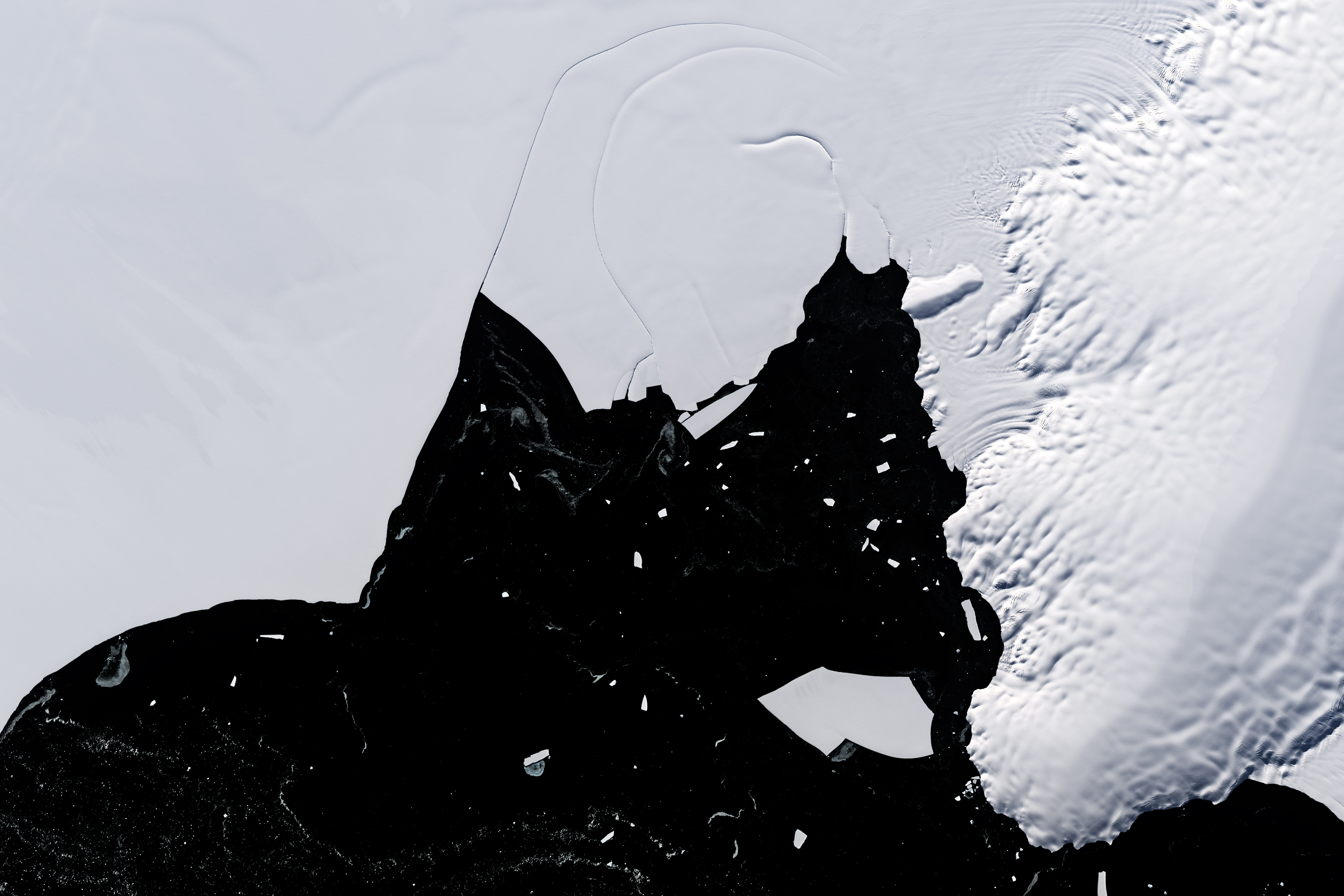
Is the Wilkins Ice Shelf Weakening? [link]
"The Wilkins Ice Shelf abuts several large islands west of the Antarctic Peninsula. The shelf’s northern ice front has undergone a series of rapid breakups since the 1990s, and it has been routinely shedding icebergs ever since.
In contrast, the shelf’s southern ice front has been historically stable, according to maps from the U.S Geological Survey. But scientists have noticed recent signs of structural weaknesses here, too, potentially signaling a shift in the shelf’s stability. As a result, scientists have been keeping a close watch on Wilkins and tracking how it is changing. Losses to ice shelves do not contribute directly to sea level rise, but they are important indicators of climate change, and they slow the seaward movement of inland glacial ice."
Interesting reads
All eyes on the Arctic Weather Satellite [link]
"ESA’s new Arctic Weather Satellite has taken centre stage at OHB’s facilities in Stockholm, Sweden, before the spacecraft is packed up and shipped to California, US, for a launch currently scheduled for June.
Embracing the New Space approach to demonstrate new concepts in a cost-effective and timely manner, the Arctic Weather Satellite has been designed to show how it can improve weather forecasts in the Arctic."
Toward Continuous Reservoir Monitoring from Space [link]
"Texas A&M researchers collaborate with NASA on updated satellites that track water reservoirs."
Battling pollution threats of Africa’s largest freshwater lake [link]
"Lake Victoria is Africa’s largest freshwater lake by area and delivers valuable ecosystem services to local communities including domestic use, industrial and agricultural water provision, waste disposal, and hydropower generation. It plays a prominent role for the landscape and can influence local meteorological and climate conditions. Lake Victoria is noted for a high diversity of fishes that are of economic, ecological, and scientific value. Nevertheless, the lake has already experienced deterioration due to unchecked or unregulated exploitation, invasive species, habitat degradation, pollution, and eutrophication. Predicted increases in climate variability and changes pose an additional threat that requires special attention."
Upcoming Events
Climate Change AI Summer School 2024 [link]
"This year’s program includes two distinct programs: a virtual program (registration now open) and a selective in-person program (application deadline: April 14, 2024).
The virtual program provides an opportunity to learn about different applications of artificial intelligence (AI) for climate action from expert researchers and practitioners, and develop expertise to make an impact in this space via lectures and hands-on tutorials. The content of the program is geared towards those that have some prior engagement with topics in either climate change or AI, and are looking to learn more about the intersection of these fields.
The in-person program aims to prepare participants to become leaders in tackling major climate problems using AI, via collaborative projects, hands-on mentorship, technical training, and leadership workshops. The in-person program is geared towards individuals with prior backgrounds in AI and/or a climate change-related field, across career stages.
Webinar: Efficient Geospatial Data Access with NASA’s AppEEARS [link]
"NASA's Application for Extracting and Exploring Analysis Ready Samples (AppEEARS) is a powerful web application and application programming interface (API) that provides intuitive access to more than 100 geospatial datasets from multiple federal agencies, including datasets at several NASA Distributed Active Archives Centers (DAACs). This webinar showcases AppEEARS and its capabilities and highlights AppEEARS resources to help simplify data access workflows using the system."