

Level-2 News
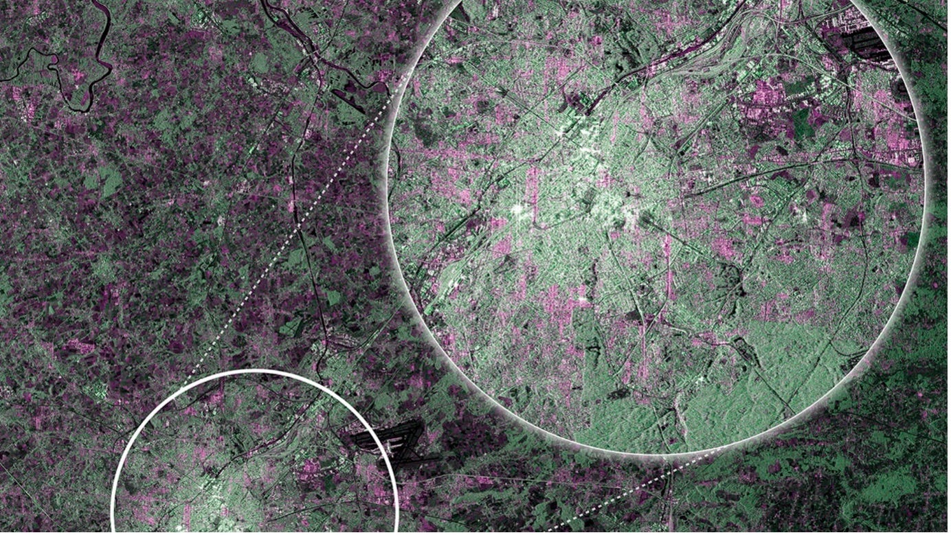
Celebrating a Decade of Copernicus Sentinel-1 [link]
"A decade after Sentinel-1A's launch on 3 April 2014, it continues to deliver large amounts of data to users each month. This mission, built on the legacy of pioneering European satellite missions like ERS and ENVISAT, has provided invaluable data across diverse applications—from ocean monitoring to disaster response, far exceeding initial expectations. Despite Sentinel-1B's retirement due to an electrical failure, the mission's legacy continues, with Sentinel-1A still operational and future satellites poised to replenish the constellation."
Sentinel-1 was the 1st Earth observation satellite for the Copernicus and as Josef Aschbacher, Director general of the European Space Agency, posted recently [its launch] "marked the start of the golden era of EO for Europe."
Planet to Provide Carbon Mapper, Inc. with Hyperspectral Data Until 2030 [link]
"Planet announced it has signed a multi-year data-license agreement with Carbon Mapper, Inc. to provide hyperspectral core imagery to the non-profit and its partners until 2030. The $20 million agreement is made possible by initial funding led by a major climate philanthropy. Carbon Mapper, Inc. has been a key partner to Planet in developing the Tanager hyperspectral constellation, and this contract extension marks an important step in the continuation of the coalition’s shared mission to help improve understanding of and accelerate reductions in global methane and carbon dioxide (CO2) emissions."
Orbital Sidekick shares first-light imagery [link]
"Orbital Sidekick released first-light imagery April 3 from two hyperspectral satellites launched March 4. The Global Hyperspectral Observation Satellites (GHOSts) launched on the SpaceX Transporter-10 rideshare flight began gathering data March 18."
SI Imaging Services is Preparing World’s Highest Res EO Satellite [link]
"SI Imaging Services (SIIS) in collaboration with its parent company Satrec Initiative, is preparing for the launch of a 100% commercial optical satellite with ultra-high resolution.
SIIS aims to innovate the domestic and international satellite data market by venturing into ultra-high-resolution (30cm) SpaceEye-T imagery in 2025, in addition to providing KOMPSAT imagery."
Zimbabwe Gets Ready to Launch Three Satellites [link]
"Zimbabwe is gearing up to launch three new satellites. One of the satellites, ZimSat-2, an Earth Observation satellite, is currently under development with advanced features and is scheduled for launch later this year. Moreover, the Zimbabwean government has approved the development of two additional satellites in the initial production phases."
ICEYE & CDC Partner on Flood Health Impacts [link]
"ICEYE has announced a new contract with the Centers for Disease Control and Prevention (CDC), which provides the federal agency with access to ICEYE Flood Insights for events across the United States and its territories."
ASTERRA and SUEZ Announce Partnership for Wastewater Solutions [link]
"ASTERRA and SUEZ announced a new contract for a water and wastewater partnership. This marks a continuation of their strategic collaborations over the past eight years.
Made official last month in Maidenhead, England, the partnership between these two industry experts includes the implementation of ASTERRA Recover and Wastewater solutions and is set to benefit everyone in the UK."
Developer's Orbit
New StoryMap Tutorial: Change Detection using OPERA RTC-S1 [link]
"This new tutorial demonstrates the process of using synthetic aperture radar (SAR) for visualizing changes in a landscape caused by distrubances such as floods, deforestation, agriculture, and freeze/thaw cycles.
It utilizes Sentinel-1 radiometric terrain corrected (RTC) SAR products created by the JPL OPERA Project and GIS software to detect differences in the backscatter signals of two images acquired over an area separated in time — before and after an event.
The tutorial steps through the process of searching for and downloading OPERA RTC data from ASF. Then it describes workflows for importing the data into ArcGIS or QGIS and performing change detection analysis.
While the workflows described in the tutorial use OPERA RTC-S1 burst products, the same workflows can be applied to Sentinel-1 frames processed using the ASF HyP3 On Demand service. This allows for studying a larger area than that covered by a single burst."

Demo showing how to estimate carbon emissions related to deforestation using data shared by Vizzuality on Source Cooperative and hosted on Hugging Face's free tier [link]
Data

Data Tool in Focus: NASA Worldview [link]
"NASA Worldview lets users interactively explore more than 1,000 global, full-resolution satellite imagery layers provided through NASA's Global Imagery Browse Services (GIBS) and then download the underlying data. In addition, many of the imagery layers available in Worldview are updated within three hours of observation, essentially showing Earth as it looks "right now," which benefits time-critical applications such as wildfire management, air quality monitoring, and flood surveillance."
SWOT KaRIn Science Data Products Release [link]
"The PO.DAAC announced the public release of Surface Water and Ocean Topography (SWOT) Ka-band Radar Interferometer (KaRIn) Science Data Products. This release includes:
KaRIn LR oceanography products from forward processing from November 23, 2023 (Cycle 7 from science phase) onward;
KaRIn LR oceanography and HR hydrology products from forward processing from January 25, 2024 (Cycle 10 from science phase) onward."
Global Vegetation Height Metrics Dataset Released [link]
"Version 1 of the Global Vegetation Height Metrics from GEDI and ICESat-2 dataset provides global rasters of relative height metrics for vegetation from Level 2A GEDI data and Level 3A ICESat-2 data at 100-, 200-, 500-, and 1000-meter spatial resolutions. GEDI data were collected from 2019 to 2022; ICESat-2 data were collected from 2019 to 2021. The data are provided in cloud optimized GeoTIFF format."
Snapshots
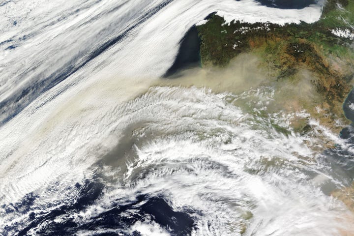
Desert Dust Envelops Portugal and Spain [link]
"Hot winds known as the “calima” brought an intrusion of dust from the Sahara Desert to Portugal and Spain in late March 2024. Suspended particles reached the region on March 21, coloring skies orange and degrading air quality for several days.
In the winter and spring, dust emerging from North Africa tends to be carried by the northeast trade winds toward the United Kingdom and western Europe, as shown here, at relatively low altitudes. In contrast, from late spring to early fall, the Saharan Air Layer carries dust westward across the Atlantic Ocean higher in the atmosphere."
Related:
Saharan dust plume [link]
Interesting reads
The State of Earth Observation [link]
"The Earth observation market is refocusing efforts on profitability, government funding, and addressing niche issues, as commercial demand has not yet materialized to the extent many anticipated.
EO insiders estimate today’s market consists of about 50% US government, 25% allied government, and 25% commercial, the latter of which primarily serves markets such as insurance, oil and gas, property, critical infrastructure, and supply chain. "

World’s worst hotspot for oil pollution by ships [link]
"In early February, a major oil slick appeared about 60km off the coast of Bintan, a northern Indonesia island near Singapore and popular with western and Asian tourists.
The ribbon of black sludge was 185km long, more than the distance from London to Birmingham, and almost 2km across at its widest point. It trailed a ship in such a way that it appeared to be the result of intentional dumping.
The oil slick was one of more than 2,700 identified globally by researchers over the past three years that emanated from passing vessels, using satellite imagery and artificial intelligence to track the pollution."
All in a year’s work: ‘Zooming’ into hurricanes, a new underwater vehicle and a fish mystery solved [link]
"From heat waves on land and in the ocean to wildfires and flooding, 2023 was a record-breaking year for climate and weather events. These events and others affected countless people across the U.S., and resulted in the highest number of billion-dollar disasters in a calendar year. Amid these enormous challenges, NOAA continued to make scientific advancements that help save lives and the planet.
Learn how NOAA’s scientific research is improving lives and the economy in the newly released 2023 NOAA Science Report. The report focuses on advancements that help create a climate-ready nation, reduce the impacts of hazardous weather, promote sustainable use and stewardship of ocean and coastal resources and ensure a robust research and development enterprise."

How NASA Spotted El Niño Changing the Saltiness of Coastal Waters [link]
"After helping stoke record heat in 2023 and drenching major swaths of the United States this winter, the current El Niño is losing steam this spring. Scientists have observed another way that the climate phenomenon can leave its mark on the planet: altering the chemistry of coastal waters."
NASA Data Shows How Drought Changes Wildfire Recovery in the West [link]
"A new study using NASA satellite data reveals how drought affects the recovery of western ecosystems from fire, a result that could provide meaningful information for conservation efforts.
In the new study, researchers analyzed over 1,500 fires from 2014 to 2020 across the West, and also gathered data on drought conditions dating back to 1984. They found that droughts make it harder for grasslands and shrublands, such as those in Nevada and Utah, to recover after fires—even the less severe blazes. Forests, if not burned too badly, rebound better than grasslands and shrublands because some forest roots can tap into water deeper in the ground. The team reported its findings in the February 2024 issue of Nature Ecology & Environment."
Transitioning from MODIS to VIIRS Global Water Reservoir Product [link]
"NASA's Global Water Reservoir (GWR) product, leveraging data from both MODIS and VIIRS, represents an important development by offering detailed insight into the dynamics of reservoirs (providing information about important reservoir metrics, such as surface area, elevation, storage, evaporation rate, and evaporation volume). It is the first operational, global-scale satellite product to provide both evaporation and storage data for 164 large reservoirs (151 man-made reservoirs and 13 regulated natural lakes). The total storage capacity of the 151 man-made reservoirs represents approximately 46% of the global capacity. Overall, this dual functionality of offering both evaporation and storage data empowers more comprehensive water security strategies."
Inventory of forests from space [link]
Space4Good and EuroNatur have joined forces with many local partners from seven countries in the Western Balkans, in the search for ancient and wild forests.

A potent planet-warming gas is seeping out of US landfills at rates higher than previously thought, scientists say [link]
"Scientists flew over more than 200 landfills across 18 states from 2018 to 2022, in what they say is the largest measurement-based survey of America’s landfills. Their results revealed average methane emissions were much higher than those officially reported, according to the study published in the journal Science."
Paper: Quantifying methane emissions from United States landfills [link]
Upcoming Events
ECMWF’s Code for Earth 2024 [link]
"Since 2018 each summer, selected developer teams work together, with experienced mentors from ECMWF and partner organisations on innovative projects. These projects are related to the broad scope of activities at ECMWF, including data science, weather, climate or other earth sciences, visualisation and more. The Copernicus Climate Change Service (C3S) and Copernicus Atmosphere Monitoring Service (CAMS) are participating again this year by being featured in some of the challenges and providing mentorship to the teams.
Browse streams and challenges on our website and join us by submitting your proposal for the 2024 edition."
Apply before 9 April