

Level-2 News
Thales Alenia Space to develop the radar instrument for ESA’s 10th Earth Explorer Harmony satellites mission [link]
"Thales Alenia Space, a Joint Venture between Thales (67%) and Leonardo (33%), signed a first 7M€ contract with the European Space Agency (ESA) to develop the Earth Observation Synthetic Aperture Radar (SAR) instrument to be embarked on the two Harmony satellites, ESA’s 10th Earth Explorer mission."
Planet Expands Strategic Partnership with SynMax, Offering Customers AI-Enhanced Vessel Identification, Classification, and Smart Surveillance Capabilities [link]
"Planet Labs announced that they have expanded into a new strategic partnership agreement with SynMax, a Houston-based satellite analytics and intelligence company. This marks an evolution in Planet’s previously announced partnership with SynMax, providing data for energy industry intelligence and dark/spoofing vessel tracking."
KSAT has acquired majority stake in Norwegian startup VAKE [link]
"Kongsberg Satellite Services, KSAT, has acquired a 70 percent majority stake in VAKE, a Norwegian startup that uses Machine Learning on satellite data for maritime domain awareness.
VAKE has been working on applying Machine Learning to satellite images to detect and analyse the behaviour of vessels, including ships that choose to hide their position, identity, and activity at sea.
While KSAT holds majority ownership, VAKE remains as an independent company with the same team, continuing to provide its offerings to the market, but now with the possibility of being integrated into KSAT's deliveries as well."
Nvidia announces Earth-2 digital twin to forecast planet’s climate change [link]
"Nvidia unveiled Earth-2 Cloud Platform for predicting climate change across the entire planet, using simulation by AI supercomputers.
In a bid to combat the increasing economic losses due to extreme weather patterns caused by climate change, Nvidia has introduced Earth-2, a revolutionary climate digital twin cloud platform. Revealed at GTC, Earth-2 offers groundbreaking APIs designed to simulate and visualize weather and climate at an unprecedented scale, paving the way for more accurate forecasts and timely warnings.
The company announced Earth-2 during the keynote by Jensen Huang, CEO of Nvidia, at the Nvidia GTC 2024 event in San Jose, California. Earth-2 was first announced in 2021, and now it’s ready."
PAX and NASA collaborate to improve earth observations work on environment, peace and security [link]
"With growing access to satellite imagery, new opportunities emerge to better understand and respond to the environmental devastation caused by armed conflicts. Therefore, NASA started the Lifelines Program to improve knowledge sharing among humanitarians and earth observation experts on the use of remote sensing data.
In a new partnership with NASA, PAX will take up a role as one of their Humanitarian Wayfinders to build a network of humanitarians, environmentalists, remote sensing specialists, and partners from conflict-affected countries. The work will also involve sharing knowledge and methods on how to apply analysis from publicly available satellite data to understand how wars and the climate crisis impact the environment people depend upon. "
Capella Space sets sights on international market for radar satellites [link]
"While the U.S. government has been Capella Space’s biggest customer for its satellite imagery generated by SAR satellites, the government of Japan is now the company’s second-largest customer for SAR data.
The company is also pursuing opportunities to build SAR satellites for the United Kingdom and the United Arab Emirates. Both nations are looking to purchase satellites that they can operate independently and integrate into their national space architectures."
Maxar eyes spring launch of long-delayed WorldView Legion satellites [link]
" After years of delays, Maxar Technologies is finally on the home stretch to launching the first two satellites of its next-generation WorldView Legion Earth-imaging constellation.
The company announced March 18 that the first two of six planned high-resolution WorldView Legion satellites have arrived at Vandenberg Space Force Base in California, paving the way for liftoff as soon as April aboard a SpaceX Falcon 9 rocket."
Earth observation camera maker raises $15 million for European expansion [link]
"Belgian camera maker Simera Sense has raised nearly $15 million to expand system assembly facilities out of South Africa and closer to its component producers in Europe to develop higher-resolution cubesat products."
Rocket Lab Launches New Satellite for Synspective’s SAR Constellation [link]
"Rocket Lab launched the fourth satellite for Japanese synthetic aperture radar (SAR) company Synspective."
US, Germany Partnering on Mission to Track Earth’s Water Movement [link]
"NASA and the German Space Agency at DLR (German Aerospace Center) have agreed to jointly build, launch, and operate a pair of spacecraft that will yield insights into how Earth’s water, ice, and land masses are shifting by measuring monthly changes in the planet’s gravity field. Tracking large-scale mass changes – showing when and where water moves within and between the atmosphere, oceans, underground aquifers, and ice sheets – provides a view into Earth’s water cycle, including changes in response to drivers like climate change.
With the international agreement signed in late 2023, the Gravity Recovery and Climate Experiment-Continuity (GRACE-C) mission will extend a nearly 25-year legacy that began with the 2002 launch of the GRACE mission. The GRACE-Follow On (GRACE-FO) mission succeeded GRACE in 2018. GRACE-C is targeting a launch no earlier than 2028."
Developer's Orbit
A new STACspec extension dedicated to the hashtag#insar products metadata [link]
"The extension is primarily intended to describe products of InSAR processing, typically interferograms and related products."
STAC Browser 3.2.0 is close to its release [link]
Enhancements in 3.2.0:
Alternate Asset support
STAC Validation with detailed reports
Metadata for links
Filter Collections by keywords
WMS rendering
UK locales
Docker improvements
Various bug fixes
Data
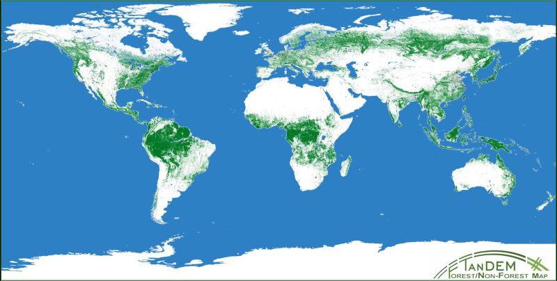
The TanDEM-X 50m Forest/Non-Forest Map [link]
"March 21 - International Day of Forests. The theme for the International Day of Forests 2024 is “Forests and Innovation: New Solutions for a Better World”.
The image above shows the global forest map which was created using interferometric data from the TanDEM-X mission and using artificial intelligence algorithms.
This data set is freely available for scientific use and provides a worldwide extent of forested areas at a resolution of up to 50 meters."
DLR Microwaves and Radar Institute LinkedIn post [link]
EMIT Methane Point Source Plume Complexes [link]
"Methane point source plume complexes measured by the EMIT imaging spectrometer on the International Space Station (ISS)"
Snapshots

Tropical storm Filipo [link]
"Tropical storm Filipo made landfall on the coast of Mozambique on 12 March, bringing high winds, heavy rainfall and flooding.
The Meteosat-9 satellite is situated over the Indian Ocean and provides imagery every 15 minutes in 12 spectral channels. "

Earth from Space: Vienna, Austria [link]
"Vienna lies in the northeastern corner of Austria and straddles the famous Danube River, visible running across the top of the image. On the left shore of the Danube, a stretch of the river can be seen forming the Danube Canal, which flows through the city parallel to the main river.
The resulting island hosts the city’s chief park, the Prater, visible as a large green area. The park comprises various leisure facilities, including a renowned amusement park. Its attractions, such as the famous Giant Ferris Wheel, are clear to see when zooming into the north of the park.
This image was acquired by the Pléiades Neo mission, a very high-resolution optical constellation, that pictures Earth with a resolution of up to 30 cm. Very high-resolution images are used in several sectors, including urban mapping, disaster response, insurance, infrastructure monitoring and agriculture."
Deforestation near Santa Cruz de la Sierra, Bolivia [link]
"This animation shows deforestation near Santa Cruz de la Sierra, Bolivia. The images were acquired over the course of four years: 2 July 1986, 16 July 1991, 13 August 2007 and 10 August 2022."
An Underwater Plume From Kavachi [link]
"Kavachi is one of the most active submarine volcanoes in the Pacific. This conical seamount, located in the Solomon Islands and named after a sea god of the Gatokae and Vangunu people, rises some 1,200 meters (3,900 feet) from the seafloor. But its summit remains just 20 meters (65 feet) below sea level, which makes it easier for satellites to detect discolorations of the water due to volcanic activity than at deeper undersea volcanoes.
Kavachi has erupted at least 39 times since 1939, with the latest eruptive period beginning in 2021, according to the Smithsonian Institution’s Global Volcanism Program. In 2024, the volcano continued to stir—and satellites continued to capture images of discolored plumes of water."
Interesting reads
Using AI to expand global access to reliable flood forecasts [link]
"Large-scale global flood forecasting has been out of reach for a long time. That has left vulnerable communities particularly in developing countries cut off from potentially life-saving information.
In a study published this week in Nature, a team from Google Research demonstrated how our AI model can significantly improve the accuracy and lead time of flood forecasts compared to the global state-of-the-art flood forecasting system."
The Power of Remote Sensing in Decoding Intermittent Rivers [link]
"Intermittent rivers, making up at least half the world's river lengths, are crucial biodiversity hotspots and provide essential services that communities depend on. Yet, interpreting their hydrology has always posed significant challenges."
Follow this article to learn more about how multispectral imagery, DEMs and data from the recently launched SWOT mission enable monitoring of intermittent rivers and ephemeral streams (IRES).
Space loves AI, AI doesn’t love Space [link]
"Space-related applications of artificial intelligence and machine learning are often confined to the ground because moving AI onboard satellites, while promising, is significantly more difficult.
AI-optimized chips are not designed for electronics that “may have to sit on the launch pad in Florida in 100-degree weather for two or three weeks and still work when it gets up to zero atmosphere and minus 40 degrees”"
Unlocking the secrets of mangroves [link]
"In the first study of its kind, FAO, with experts around the world, uncovered a wealth of information on the extent of mangrove forests globally, as well a glimpse into what causes mangrove losses and gains."
Taking Earth’s temperature from space
"Climate change exacerbates droughts by making them more frequent, longer, and more severe. This can have a wide range of impacts on the environment, agriculture, ecosystems and communities including water scarcity, crop failure and food shortages.
The upcoming Copernicus Land Surface Temperature Monitoring, LSTM, mission will improve sustainable agricultural productivity in a world of increasing water scarcity and variability.
The mission will carry a high spatial-temporal resolution thermal infrared sensor to provide observations of land-surface temperature.
These data are key to understand and respond to climate variability, manage water resources for agricultural production, predict droughts and also to address land degradation.
LSTM is one of six Copernicus Sentinel Expansion missions that ESA is developing on behalf of the EU. The missions will expand the current capabilities of the Copernicus Space Component – the world’s biggest supplier of Earth observation data.
This video features interviews with Ana Bolea Alamanac, LSTM Mission Project Manager, Ilias Manolis, LSTM Mission Payload Manager and Itziar Barat, LSTM Mission System and Operations Manager."
'The night might not save us': New study shows drought drives overnight burning of wildfires [link]
"The welcomed slowing of a wildfire's destruction that comes with the cool and humidity of nightfall shrinks and even disappears during drought conditions, according to a University of Alberta researcher whose new study published in Nature challenges conventional fire management practices.
In their study, the team examined 23,557 fires in North America between 2017 and 2020, using a combination of satellite and terrestrial data to analyze the burn cycle of these fires and identify overnight burning events."
UP42, Geoawesomeness Unveil 2024 Report on the Adoption of Earth Observation [link]
"UP42, a leading geospatial developer platform and marketplace, together with Geoawesomeness, a long-established community about geospatial technologies, have released a special report unveiling insights into the adoption of Earth observation in 2024. This report, unveiled during an event on March 12th, is part of the EO Hub initiative, a journalistic collaboration between UP42 and Geoawesome.
Conducted between September and December 2023, UP42 and Geoawesomeness ran a comprehensive industry survey that drew responses from professionals around the globe. The report provides an in-depth analysis of emerging trends, challenges, and the evolving landscape of EO data applications."
Scientists Hack Weather Satellite Data to Quantify Methane Leaks [link]
"Satellites sitting more than 22,200 miles (35,700 kilometers) above the Earth’s surface have been capturing storms and weather data for decades. Now, scientists have essentially hacked the data coming back for another purpose: spotting methane emissions."
LinkedIn Highlights

Fact-checking news items with remote sensing [link]
Follow this LinkedIn post by Jeff Pennings who used Sentinel-1 imagery to fact-check a recent news item about reduced number of transits through Panama Canal. This is a great example of how to use satellite imagery in verifying information.
Related:
How Journalists Can Benefit From Near Real-Time Satellite Imagery [link]
The launch of ECMWF User Community LinkedIn page [link]
This LinkedIn page targets techincal users and will feature in-depth technical insights, important events and user showcases.
Podcasts
Destination Earth with Lothar Wolf
"Destination Earth is an initiative from the European Commission to develop a highly-accurate digital model of the Earth (a digital twin) to model, monitor and simulate natural phenomena, hazards and the related human activities. Find out more about the initiative, by diving into this podcast interview with EUMETSAT's DestinE Programme Manager, Lothar Wolf."
EP #90 Building The World's Most Powerful Satellites w/ Will Marshall [link]
"Catch Will Marshall talk with Peter H. Diamandis about how Planet satellite data is being used to solve some of the world's biggest challenges across agriculture, deforestation, global security, and more."
Upcoming Events
EPIC Webinar for ESA BIC and ESA supported start-ups [link]
"The ESA Partnership Initiative for Commercialisation (EPIC) is an initiative from the ESA Commercialisation Department connecting corporate partners with ESA supported start-ups.
This webinar will present the offers available through EPIC and is an exclusive event for the below stakeholders.
Start-ups supported via the ESA BIC Network (incubatees and alumni);
Spark projects supported by the ESA Technology Broker;
Companies supported via ESA InCubed Programme; and
Representatives from ESA's Commercialisation Networks (ESA BICs, ESA Technology Brokers, ESA)"
7th OpenIFS User Meeting [link]
"The 7th OpenIFS User Meeting will take place at ECMWF’s headquarters in Reading, UK.
This meeting is organised by ECMWF for the OpenIFS model’s user community. It represents an opportunity for the model users to meet in person and showcase their research and to learn about new developments with OpenIFS. The aim is to foster networking and collaborations among model users. "
ECMWF | Reading, UK | 13-16 May 2024