

Level-2 News
SpaceX launches Transporter-10 rideshare from Vandenberg [link]
"On Monday, March 4, 2024, SpaceX launched the Transporter-10 rideshare mission from Space Launch Complex 4E at Vandenberg Space Force Base (VSFB)."
A total of 53 payloads were launched during the mission.
Below are the EO payloads I've singled out:
MethaneSAT - the first satellite by a nonprofit environmental group. MethaneSAT will collect data about methane leaks from 300 targets worldwide while circling Earth 15 times a day from its orbit 360 miles (580 kilometers) above ground, according to the mission plan [link].
Related: Google-backed satellite to track global oil industry methane emissions [link]ICEYE launched three new SAR satellites, including a 1200 MHz radar bandwidth in-orbit technology demonstrator that will enable 25 cm imaging [link]
Satellogic launched their 16th mission; a high-resolution optical and hyperspectral satellite
"Orbital Sidekick added the GHOSt-4 and GHOSt-5 satellites to their hyperspectral imaging constellation. These 90 kilogram spacecraft can detect methane emissions with eight meter resolution"
Satlantis launched their sixth mission - HORACIO - a 16U Earth observation CubeSat, with a high-resolution multi-spectral imaging payload
ContecSat-1/Oreum; an earth observation 16U CubeSats bult for the South Korean company Contec
UK firm Open Cosmos launched its first satellite; IOD-6 Hammer, equiped with a hyperspectral imager [link]
Esper launched its first demonstration satellite, equiped with a hyperspectral camera
Related: Australian space startup Esper wants to build hyperspectral sats for cheap [link]Loft Orbital launched YAM-6 - the first virtual mission-enabled satellite; its payloads include hyperspectral and multi-spectral imagers
Related: Loft Orbital: The rise of the virtual mission [link]RROCI-2 from Orion Space Solutions; a 12U CubeSat demonstration for the US Space Force to provide cloud characterization weather data supporting the Department of Defense
Related: Space Force’s weather-imaging mission takes flight again after initial setback [link]MuSat-2 from Muon Space will also demonstrate weather data collection for the Department of Defense
Related: Muon Space tapped by Air Force for cloud characterization from space [link]

SWOT Satellite Catches Coastal Flooding During California Storms [link]
"A series of atmospheric rivers drenched California in February, with record amounts of rainfall and hurricane-force winds sweeping across parts of the state. At one point, weather agencies posted flood watches for nearly the entirety of California's coast. The Surface Water and Ocean Topography (SWOT) mission captured data on some of the flooding near the community of Manchester, roughly 105 miles (169 kilometers) north of San Francisco."

Ship sunk by Houthis threatens Red Sea environment, Yemen government and US military say [link]
"On February 18th, Houthi militants attacked the Rubymar, a UK-owned commercial vessel traveling a critical shipping route through the Red Sea. Planet imagery from two days after the missile strike reveals the 18-mile oil slick trailing behind the damaged ship."
El Niño weakens but impacts continue [link]
"The 2023-24 El Niño has peaked as one of the five strongest on record. It is now gradually weakening but it will continue to impact the global climate in the coming months, fuelling the heat trapped by greenhouse gases from human activities. Above normal temperatures are predicted over almost all land areas between March and May."
Gro Intelligence lays off 60% of staff, secures some 11th hour funding [link]
"Ag insights platform Gro Intelligence laid off 60% of its staff on Friday but is understood to have secured some 11th hour funding."
Related:
Follow Aravind's take on the news and the discussion in the comment section. [link]
Planet Wins Contract from Naval Information Warfare Center for Vessel Detection [link]
"Planet Labs Federal, a subsidiary of Planet Labs, was awarded a contract by the Naval Information Warfare Center (NIWC) Pacific for vessel detection and monitoring over key areas in the Pacific.
The project will integrate both Planet’s SkySat data and PlanetScope data into the Department of Transportation’s SeaVision platform, a maritime situational awareness tool. The PlanetScope constellation will provide the SeaVision platform with a comprehensive view of millions of square kilometers of the Pacific Ocean. NIWC Pacific will utilize Planet’s SkySat data to capture finer detail. The SeaVision platform will adopt electro-optical imagery-derived vessel detections and tasked imagery to improve maritime domain awareness throughout the region. "
Developer’s Orbit
Plans for high-resolution forecast (HRES) and ensemble forecast (ENS) control run [link]
"With the upgrade of the Integrated Forecasting System (IFS) to Cycle 48r1 in June 2023, the horizontal resolution of medium-range ensemble forecasts (ENS) increased from 18 to 9 km, bringing it to the same resolution as the high-resolution forecast (HRES)."
TROPESS Tutorials & Notebooks [link]
Learn how to work with NASA TROPESS CrIS JPSS-1 Carbon Monoxide datasets
[LinkedIn post]
Data
Umbra releases over $4 Million in free SAR Data [link]
Umbra announced that it has made over $4 million of Synthetic Aperture Radar (SAR) data available to the public via its Open Data Program, which launched on March 15, 2023.
MajorTOM-Core: the largest ML-ready Sentinel-2 dataset [link]
"About half of the entire planet is covered. That's 2,245,886 patches of 1068 x 1068 pixels, available in both L1C and L2A. At 10 m resolution, we've got 256 million square km with over 2.5 trillion pixels. It's all yours with a few lines of code."
[HuggingFace]
[HuggingFace post]
Major TOM: Expandable Datasets for Earth Observation [Paper]
Snapshots
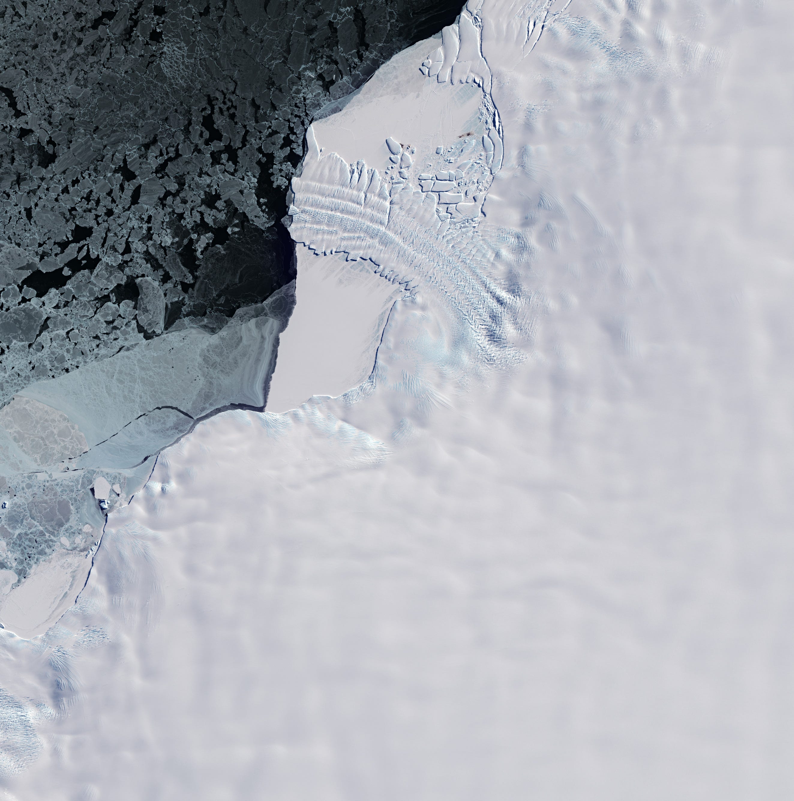
Earth from Space: Dawson-Lambton Glacier home to penguins [link]
"The Dawson-Lambton Glacier lies southwest of the Brunt Ice Shelf in the Weddell Sea sector of the continent.
Patterns on and around the glacier depict crevasses and rumples, resulting from pressure as the glacier slides towards the sea. Over the past decades, glaciologists have used satellite data to monitor the glacier’s retreat. "
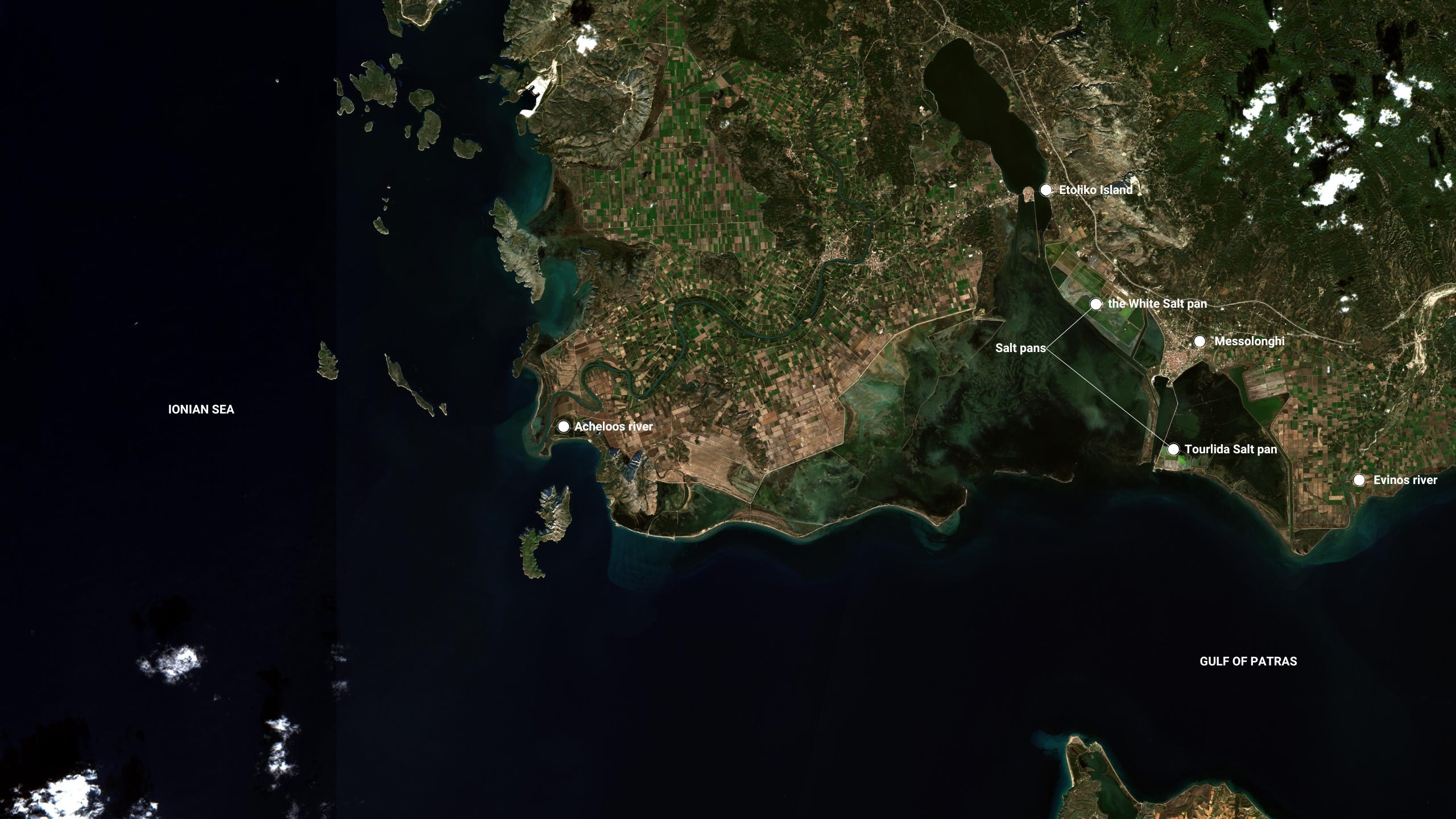
EarthSnaps: The Messolonghi - Etoliko Lagoon system [link]
"The lagoons are located in the central west coast of Greece, where the Patraikos Gulf meets the Ionian Sea. It is a shallow area of 150 km2, extending between the Acheloos and Evinos rivers.
Protected by the Ramsar Convention on Wetlands, and included in the Natura 2000 network, the Messolonghi-Etoliko Lagoon National Park is rich in flora and fauna, including more than 290 species of birds and more than 100 species of fish."
A year of weather 2023
A whole year of weather in just 10 minutes. This visualisation allows you to relive the major weather events of 2023 on a global scale.

18 European landmarks in satellite images [link]
"Explore famous European landmarks through an interactive map"
Interesting reads
Machine learning ignites wildfire forecasting [link]
Follow this article, by Joe McNorton, a scientist working in both the Coupled Processes Group and the Fire Forecasting Group at ECMWF, on using machine learning for fire forecasting and the new tool they developed: Probability of Fire (PoF).
New analysis shows that the global freshwater cycle has shifted far beyond pre-industrial conditions [link]
"A new analysis of freshwater resources across the globe shows that the updated planetary boundary for freshwater change was surpassed by the mid-twentieth century. In other words, for the past century, humans have been pushing the Earth's freshwater system far beyond the stable conditions that prevailed before industrialization."
Can Volcanic Super Eruptions Lead to Major Cooling? Study Suggests No [link]
"New research suggests that sunlight-blocking particles from an extreme eruption would not cool surface temperatures on Earth as severely as previously estimated.
Some 74,000 years ago, the Toba volcano in Indonesia exploded with a force 1,000 times more powerful than the 1980 eruption of Mount St. Helens. The mystery is what happened after that – namely, to what degree that extreme explosion might have cooled global temperatures."
NASA’s Global Precipitation Measurement Mission: 10 years, 10 stories [link]
"From peering into hurricanes to tracking El Niño-related floods and droughts to aiding in disaster responses, the Global Precipitation Measurement (GPM) mission has had a busy decade in orbit. As the GPM mission team at NASA and the Japan Aerospace Exploration Agency (JAXA) commemorates its Feb. 27, 2014 launch, here are 10 highlights from the one of the world's most advanced precipitation satellites."
Night-shining cloud mission ends; yields high science results for NASA [link]
"After 16 years studying Earth's highest clouds for the benefit of humanity—polar mesospheric clouds—from its orbit some 350 miles above the ground, NASA's Aeronomy of Ice in the Mesosphere, or AIM, mission has come to an end."
Upcoming Events
EUMETSAT series of short courses: Monitoring and modelling extreme waves using altimetry [link]
"This advanced event will focus on the application of satellite altimetry measurements to monitor and forecast extreme waves. It will present some technical background on how significant wave height products are derived from the radar altimeter measurements.
The short course will consist of a 2-hour webinar on March 13 (12:00 - 14:00 UTC), which will include a Q&A and feedback session."
Webinar: Accessing Data for the World's Water with NASA's SWOT Mission [link]
"Learn how to discover, access, and use Surface Water and Ocean Topography (SWOT) mission data and how these data could lead to new, innovative science and applications in the world of water.
Presenter: Dr. Cassandra Nickles and Celia Ou, NASA's PO.DAAC
Start Mar 20, 2024 2:00 ET (-0400 UTC)
End Mar 20, 2024 3:15 ET (-0400 UTC)"
ECMWF’s Code for Earth 2024 [link]
"Code for Earth is an innovation programme run by the European Centre for Medium-Range Weather Forecasts (ECMWF). Its aim is to drive innovation and open source developments in the Earth sciences community - supporting developments in weather and climate, Copernicus and Destination Earth (DestinE)."