Level-2 News
IHME, Microsoft, And Planet Collaborate To Map Climate-Vulnerable Populations In Unprecedented Detail [link]
"This new collaboration between Planet, Microsoft’s AI for Good Lab and the Institute for Health Metrics and Evaluation (IHME) at the University of Washington aims to identify and mitigate risks in climate-vulnerable communities.
Together, they are using satellite imagery, AI and spatial demography to develop high-resolution, comprehensive, and up-to-date population maps, starting in low-resource/high-climate-stress countries. The resulting maps can be used to help model exposure to climate-linked migration risks, food insecurity, disease burden, and many other contemporary hazards."
NRO Selects Umbra for second phase of commercial RF study [link]
" The NRO has selected Umbra, for the Stage II option of its Commercial RF Capabilities contract under the Strategic Commercial Enhancements (SCE) effort. The purpose of Stage II is to deliver RF products to validate on-orbit performance as well as assess mission utility and integration of U.S. domestic commercial RF capabilities into the wider U.S. Government architecture."
NGA goes big on commercial satellite data with $290 million 'Luno' program [link]
"The National Geospatial-Intelligence Agency is supercharging its use of commercial satellite imagery and analytics with a new procurement program dubbed 'Luno'
The Luno program intends to demonstrate a tangible commitment to commercial Earth observation services, he added."
Iran successfully launches domestically-built Pars 1 research satellite into space [link]
"The 134-kilogram satellite was launched by a Soyuz rocket from the Vostochny Cosmodrome in Russia's far eastern Amur region on Thursday.
Equipped with three cameras, Pars 1 will scan Iran's topography from an orbit of 500 kilometers above the Earth's surface."
ESA selects Dutch satellite system for local emission monitoring [link]
"The European Space Agency (ESA) has given the green light for the realization of the Dutch TANGO satellites. TANGO measures greenhouse gas emissions at source level from power plants, coal mines, landfills and factories, among others. Its Dutch predecessor TROPOMI has already been monitoring the greenhouse gas methane worldwide since 2017 and can map about 5% of emission sources. Its successor TANGO will be able to monitor sources responsible for around 75% global emissions of methane. Moreover, TANGO measures emissions of CO2, the gas that accounts for the largest output of greenhouse gas emissions worldwide. The satellites are being developed by the Dutch parties ISISPACE, TNO, SRON and KNMI. TANGO is expected to be ready for launch from early 2027."
Copernicus ECMWF launched the Interactive Climate Atlas [link]
"This new tool builds on the open access data of the IPCC Climate Atlas and enables exploration of CMIP6 climate projection scenarios and other datasets including both observations and reanalysis.
The C3S Atlas allows exploration of some of the most authoritative climate datasets. The reanalysis and observational datasets are more suitable for users seeking information about the present and past climate, while those interested in the possible future outcomes can explore the projections."
Related:
Copernicus ECMWF announces the launch of Climate Pulse [link]
SkyFi Announces Integration of Satellogic Submeter Archives [link]
"SkyFi is announced the integration of Satellogic's satellite imagery archives into their platform.
Archive data is a valuable tool for a variety of applications, offering a baseline for change analysis, especially damage assessments following disasters or conflicts. Satellogic high-resolution archive data is also an affordable option for creating models and training algorithms, such as object detection, and remote asset monitoring, e.g. annual and/or seasonal monitoring of infrastructure."
Recently:
SkyFi Integrates GEOSAT Tasking Capability [link]
Data
Discover the latest additions to the gee-community-catalog.org [link]
the Canadian Satellite-Based Forest Inventory (SBFI), spanning over 650 million+ hectares of forested areas in Canada
a Land cover dataset the GLC_FCS30D - Global 30-meter Land Cover Change Dataset (1985-2022), currently under review as early access
Snapshots
Making Sense of Holes in the Clouds [link]
"Cavum clouds, also called hole-punch clouds and fallstreak holes, look so odd that people sometimes argue they are signatures of flying saucers or other unidentified anomalous phenomena. Seen from below, they can look like a large circle or ellipse has been cut neatly from the clouds, with feathery wisps left in the middle of the hole.
Otherworldly explanations are not required to explain the eye-catching cloud formation. While scientists have periodically mentioned the phenomena in scientific journals and speculated about their cause since the 1940s, a pair of studies published in 2010 and 2011, led by University Corporation for Atmospheric Research (UCAR) scientists, laid out an explanation that put other theories to rest. They are caused by airplanes moving through banks of altocumulus clouds."
Interesting reads
A digital twin to sharpen our vision of extreme weather [link]
"With weather-induced extremes becoming more frequent and intense in a changing climate, the Weather-Induced Extremes Digital Twin of Destination Earth, developed by ECMWF together with a European consortium led by METEO FRANCE, will produce bespoke cutting-edge simulations of extreme events. The objective is to support decision-makers, boosting our ability to anticipate the impacts and take action to prevent the worst consequences."
The Biggest Challenges With Geospatial Analysis [link]
"Part two of Striveworks's interview with Capella Space Senior Product Manager Brett Foreman about solving some of the greatest challenges with #geospatial analysis."
GAO report on Artificial Intelligence in Natural Hazard Modeling [link]
"The US Government Accountability Office (GAO) published a report at the end of 2023 on Artificial Intelligence in Natural Hazard Modeling: Severe Storms, Hurricanes, Floods, and Wildfires, identifying several potential benefits of applying machine learning to this field, as well as challenges surrounding the use of machine learning."
A sneak peak at the first SWOT hydrology products [link]
"SWOT, the Surface Water and Ocean Topography mission was successfully launched more than a year ago (Dec 16, 2022). Hydrologists are eagerly awaiting the release of SWOT products, which will allow them to study for the first time the water levels variations of more than a million lakes and rivers around the globe!
A first batch of products from the SWOT mission has been released by NASA and CNES. As explained in the release note, these SWOT products are « at a very early stage, with known limitations ». The hydrology products span only two weeks in April 2023."
New mission to track changes in the cryosphere
"Tracking ice lost from the world’s glaciers, ice sheets and frozen land shows that Earth is losing ice at an accelerating rate. Monitoring the cryosphere is crucial for assessing, predicting and adapting to climate change.
The Copernicus Polar Ice and Snow Topography Altimeter (CRISTAL) mission will provide a full picture of the changes taking place in some of the most inhospitable regions of the world. It will carry – for the first time – a dual-frequency radar altimeter, and microwave radiometer, that will measure and monitor sea-ice thickness, overlying snow depth and ice-sheet elevations.
This video features interviews with Kristof Gantois, CRISTAL Project Manager and Paolo Cipollini, CRISTAL Mission Scientist."

Satellites increasingly critical to monitor ocean health [link]
"Playing a huge role in moderating the climate, oceans are fundamental to the functioning of our planet. Understanding more about how seawater temperatures are rising and how oceans are absorbing excess atmospheric carbon dioxide, as well as knock-on issues such as ocean acidification, is key for understanding climate change and for taking effective action.
A recent scientific paper highlights just how satellites are becoming increasingly important in providing unique information on ocean health to guide climate mitigation and adaptation efforts."
Antarctic Sea Ice Minimum, 2024 [link]
"On February 20th, 2024, Antarctic sea ice officially reached its minimum extent for the year. This cycle of growth and melting occurs every year, with the ice reaching its smallest size during the southern hemisphere's summer.
This year's melt season concluded with a sea ice area of 768,000 square miles (1.99 million square kilometers) compared to the average minimum observed during the satellite era (1981-2010). That is slightly larger than the state of Texas.
According to the National Snow and Ice Data Center, this marks the second-lowest sea ice extent recorded by satellites, reflecting a trend of declining coverage over time."
Ground Stations Explained: How Does Satellite Data Travel from Space to Earth? [link]
"With the focus usually on building and launching a spacecraft into orbit, as well as the user segment when accessing and analyzing earth observation data, the ground segment is often overlooked. However, it is one of the most important elements of the space system. Being able to operate a satellite from the ground and download data back to Earth is vital to the success of an Earth observation mission."
Upcoming Events
STAC Night Berlin [link]
"Are you a researcher, developer, or data provider enthusiastic or curious about STAC? Join us for a special STAC night in Berlin on Wednesday, April 17 at 18:15.
Connect with fellow community members, enjoy food and drinks, and engage in discussions. The evening kicks off with 60 minutes of lightning talks followed by open discussions, and networking. Register by April 9th."
Learning
ASF NISAR Early Adopters Workshop 2024
"The Alaska Satellite Facility (ASF), in collaboration with the NASA JPL NISAR Early Adopters Program, held a two-day workshop that was designed to prepare participants to work with NISAR data using ASF's OpenScienceLab, a multi-user JupyterHub environment that operates in AWS.
Workshop Recordings [link]
Workshop Slides [link]
Jupyter Notebook Repo [link]"
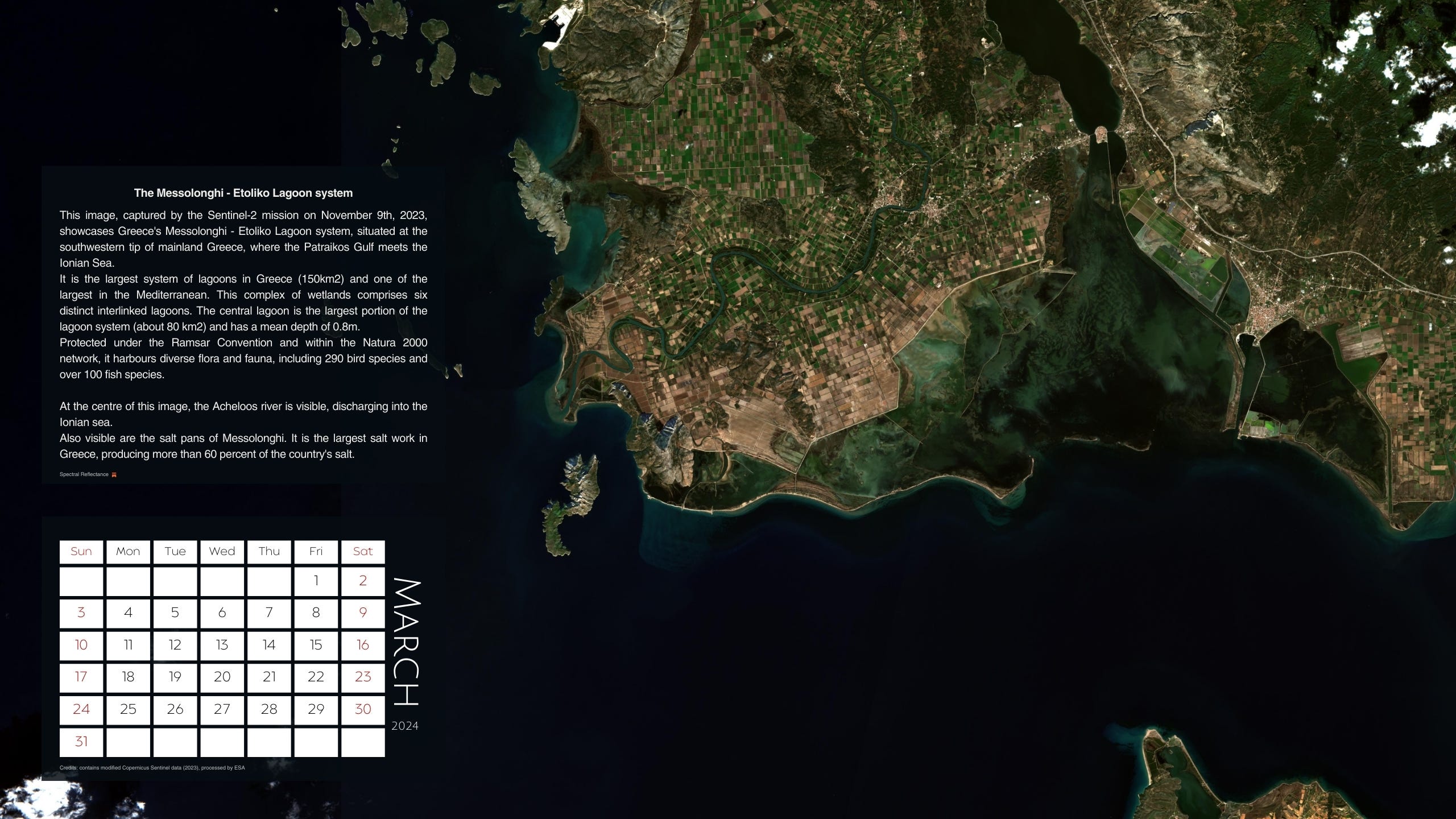
Spectral Reflectance 2024 Calendar - Greece from above [link]
March 2024: The Messolonghi - Etoliko Lagoon System