

Level-2 News

ERS-2 reenters Earth’s atmosphere over Pacific Ocean [link]
"At approximately 18:17 CET (17:17 UTC) on Wednesday 21 February 2024, ESA’s ERS-2 satellite completed its atmospheric reentry over the North Pacific Ocean.
ESA’s second European Remote Sensing satellite, ERS-2, was launched almost 30 years ago, on 21 April 1995. Together with the almost-identical ERS-1, it provided invaluable long-term data on Earth’s land surfaces, ocean temperatures, ozone layer and polar ice extent that revolutionised our understanding of the Earth system. It was also called upon to monitor and assist the response to natural disasters."
Related:
Pioneering European ERS-2 satellite burns up over Pacific [link]
ISRO Launches INSAT-3DS Meteorological Satellite [link]
"INSAT-3D meteorological satellite was successfully launched from the Satish Dhawan Space Centre in Sriharikota on the GSLV-F14. It deployed the INSAT-3DS into the intended geosynchronous transfer orbit."
Synspective SAR Satellite “StriX-3” to be Launched in March [link]
"Synspective Inc., a Synthetic Aperture Radar (SAR) satellite data and analytic solutions provider, announced the official launch schedule of StriX-3, the company’s SAR satellite.
The StriX-3 mission is scheduled to launch during an 8-day window that opens on March 9th UTC.
StriX-3 is the company’s fourth SAR satellite, following StriX-α, StriX-β, and StriX-1, launched in December 2020, March, and September 2022, respectively."
NUVIEW Acquires Astræa to Leverage AI for Earth Observation [link]
"NUVIEW, an Earth observation and geospatial technology company building the world’s first commercial LiDAR satellite constellation, has acquired Astræa, Inc., a software-as-a-service (SaaS) platform.
Astræa’s AI-driven distribution and analysis tools will enable NUVIEW to immediately execute its strategy to develop a high-throughput Earth observation data superhighway that empowers global distribution partners and their customers."
SkyFi Partners with Ursa Space Systems to Offer Advanced Global Oil Inventory Analytics [link]
"SkyFi and Ursa Space Systems announced a strategic partnership to bring comprehensive commodity products and insights to market. This partnership brings together SkyFi's web and mobile apps with Ursa's advanced satellite-derived analytics, addressing market-ready product initiatives around oil inventories and bulk commodity stockpile monitoring at globally significant sites."
NASA Joins Group to Advance Wildfire Coordination, Capabilities [link]
"NASA is now an associate member of the National Wildfire Coordinating Group (NWCG), giving the agency new opportunities to collaborate with federal agencies and other partners to better understand wildland fires and leverage technology and innovation to prevent and manage them for the benefit of humanity."
"Through the NWCG, NASA will play a crucial role in advancing the National Cohesive Wildland Fire Management Strategy's goals, including restoring and maintaining resilient landscapes, creating fire-adapted communities, and responding to wildfires safely and effectively." [link]
Planet’s Crisis Response Program has made available select non-commercial data for the ongoing wildfires in Chile [link]
"Planet’s Crisis Response Program has made available select non-commercial data for the ongoing wildfires in Chile. This dataset is reserved for qualified users affiliated with an organization and directly assisting with response efforts."
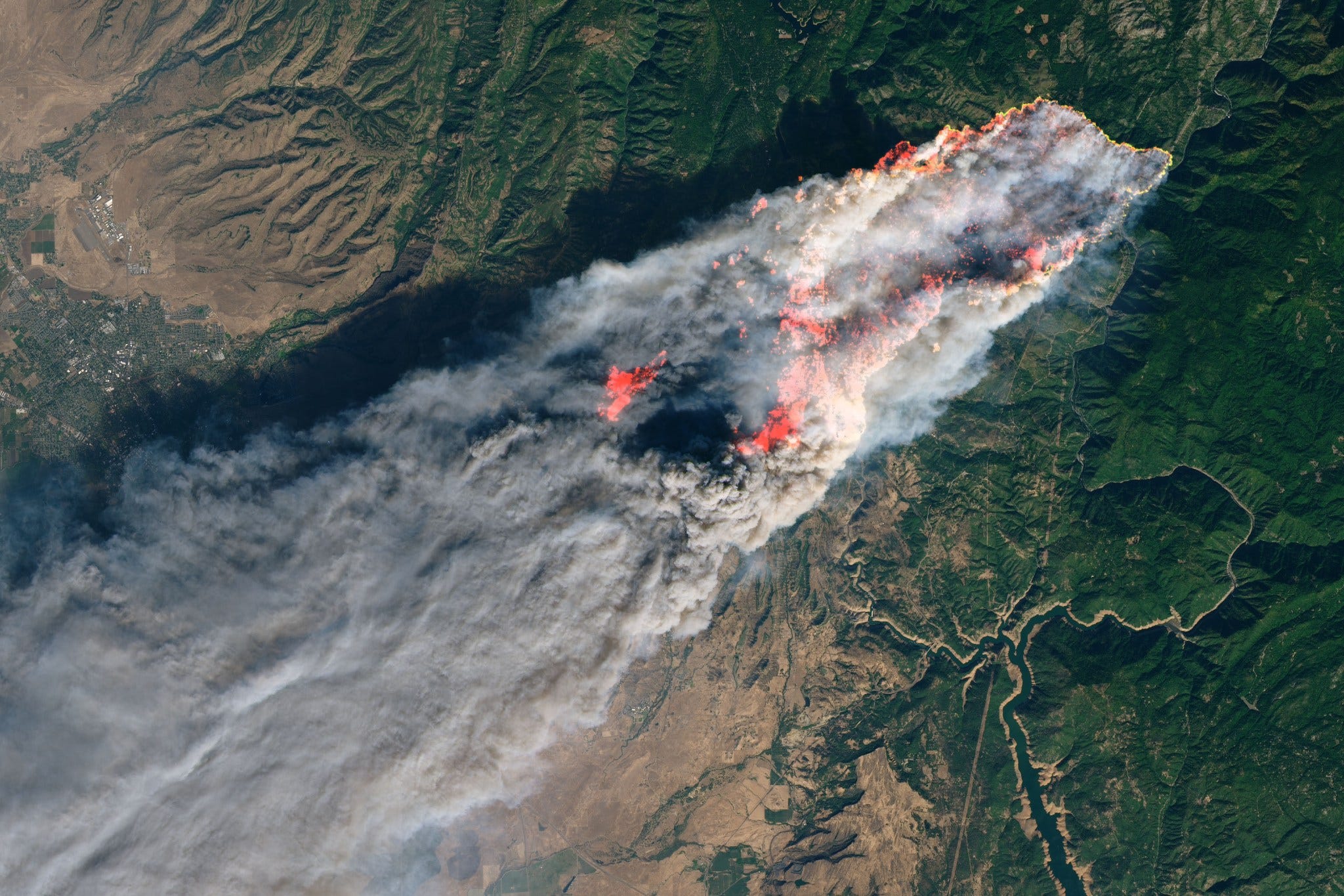
In Pictures: Turkey Gold Mine Landslide Causes Heaps of Destruction [link]
"A landslide disaster occurred in the Erzincan district of Turkey on Tuesday, trapping nine workers at a goldmine.
Satellite imagery shows the scale of the landslide, with heaps of earth gathered over the area, spilling into the mine and resulting in destruction."
Snapshots
A Rare Tropical Storm in the South Atlantic [link]
"Tropical storms seldom roam in the South Atlantic Ocean. But in mid-February 2024, one such storm formed off the coast of Brazil.
The disturbance began to develop as a stalled front of low pressure on February 15. According to researchers at NOAA’s Cooperative Institute for Meteorological Satellite Studies (CIMSS), the front formed into a subtropical depression on February 16 after being fed by a plume of tropical moisture that plunged south."
Landsat 2023 - A Year in Review
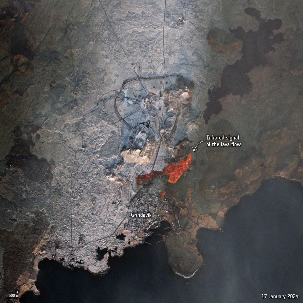
Solidified lava near the Icelandic town of Grindavík [link]
"Satellite imagery taken on Jan. 27 by the European Space Agency's (ESA) Copernicus Sentinel-2 mission shows dark patches of solidified lava near the fishing village of Grindavik in Iceland's Reykjanes Peninsula. Areas covered in the solidified lava stand out against the contrast of freshly fallen white snow, ESA officials said in a statement describing the new image."

Yi Sun-Sin Bridge, South Korea [link]
Download the image through Umbra's Open Data Catalog [link]

Krakatau volcano [link]
"Krakatau, a small island group in the Sunda Strait between the islands of Sumatra and Java is one of the world's most famous volcanoes. It is a mostly submerged caldera with 3 outer islands belonging to the rim and a new cone, Anak Krakatau, that has been forming a new island since 1927 and remains highly active."
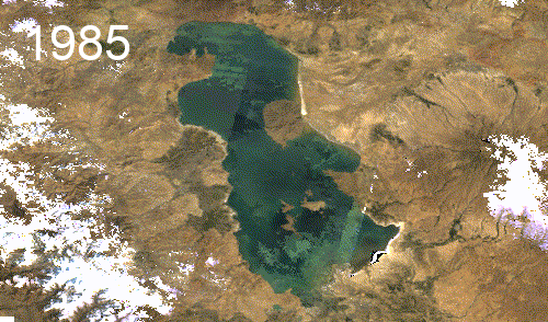
Lake Urmia's ecological crisis [link]
Mohsen Tahmasebi Nasab created this timelapse highlighting the dramatic changes in the extend of Lake Urmia in Iran.
Related:
Iran’s Lake Urmia Is Lying On Its Deathbed With A Small Window Of Time Left To Save It, Experts Warn [link]
Interesting reads
Satellite observations capture dynamics of Greenland meltwater lakes [link]
"The Greenland Ice Sheet is one of the biggest contributors to global sea level rise and, as the polar climate warms, this contribution is increasing. The decrease in the mass of the ice sheet is split approximately evenly between runoff of meltwater and flow of Greenland’s glaciers into the ocean. ESA’s 4DGreenland project aims to use satellite observations to better understand the meltwater budget of the Greenland Ice Sheet.
The latest results from 4DGreenland have been published this week in two articles in The Cryosphere. The articles highlight how satellite Earth Observation can be used to improve understanding of dynamic meltwater processes in Greenland, both at the surface and base of the ice sheet."
Spy satellite images offer insights into historical ecosystem changes [link]
"A large number of historical spy-satellite photographs from the Cold War Era were declassified decades ago. This valuable remote sensing data has been utilized by scientists across a wide range of disciplines from archaeology to civil engineering. However, its use in ecology and conservation remains limited."
Five Key Needs for Addressing Flood Injustice [link]
"Better data and assessment metrics—and improved researcher involvement in communities—are needed to understand and redress inequitable vulnerabilities to and recoveries from flooding."
How satellites, algorithms and AI can help map and trace methane sources [link]
"Environmental Defense Fund’s satellite, MethaneSAT, will soon orbit the Earth to collect satellite data. This data, combined with Google’s AI and infrastructure mapping, will create a better understanding for how to mitigate methane emissions."

Behind the data: measuring ocean carbon [link]
"Marine remote sensing expert Dr Hayley Evers-King explains how satellite images of plankton can be used to identify where and how much carbon is stored in the ocean and why tracking carbon is so essential."
When Eyes in the Sky Start Looking Right at You [link]
Even though this doesn’t exactly fit in this newsletter, it does contain a few cases of "satellite journalism"; from Landsat 5 confirming the 1986 Chernobyl Disaster to The Associated Press winning a Pulitzer Prize for uncovering labor abuses in the seafood industry that amounted to slavery, using satellite images.
Simonetta Cheli at the Academic Year of Florence [link]
"During the inauguration of the academic year of the University of Florence, Simonetta Cheli underlined the crucial importance of space technologies in the fight against the climate crisis. Through Earth observation, satellites provide indispensable data to tackle climate change, support sustainability goals and promote the management of natural resources."
Read the full article here.