

Level-2 News
Deloitte Launches Geospatial and AI Scenario Planning and Monitoring Platform Powered by Google Cloud [link]
"Deloitte will apply Google Earth Engine and AI to help clients make more sustainable decisions and take action to mitigate the impacts of climate change
As part of its new platform, Deloitte will leverage Google Earth integrations, GEE and Vertex AI to improve operational resilience and help organizations proactively anticipate and plan for a myriad of challenges, such as urban planning, disaster response and infrastructure development. The platform will enable more informed decision-making and sustainable planning capabilities, such as applying Generative AI to sandbox and test community readiness for rising sea levels."
Chinese company launches 5 remote-sensing satellites to orbit [link]
"The third Kinetica-1 solid rocket lifted off from Jiuquan Satellite Launch Center in northwest China at 11:03 p.m. EST on Monday (Jan. 22; 0403 GMT and 12:03 p.m. Beijing time on Jan. 23).
Aboard were five Taijing satellites, all designed and built by Beijing-based private satellite maker Minospace.
The Taijing-1C, 2B, 2D, 3B and 4C satellites are remote-sensing satellites for varying purposes. The first four are optical remote-sensing satellites, while Taijing-4C is a phased array synthetic aperture radar satellite operating in the Ku-band portion of the electromagnetic spectrum"
Greece set to acquire CubeSat constellation [link]
"The Greek Ministry of Digital Governance has announced a National Microsatellite Program which aims to strengthen the country’s off-planet capabilities in low Earth orbit.
The ministry has put forth an open competition on the international market for the development of a CubeSat constellation, with a budget of €60 million from a total of €130 million.
The plan is set to be materialized via the European Space Agency (ESA) and is funded by the National Recovery & Resilience Plan Greece 2.0.
According to the ministry’s announcement, the CubeSat constellation will aid the state in multiple ways, such as with the observation of the environment, logging long-term changes and dealing with climate change."
NASA’s PACE Spacecraft Mated to Payload Adapter [link]
"NASA and SpaceX technicians connected NASA’s PACE (Plankton, Aerosol, Cloud, ocean Ecosystem) spacecraft to the payload adapter on Wednesday, Jan. 24, 2024, at the Astrotech Space Operations Facility near the agency’s Kennedy Space Center in Florida.
The PACE mission will increase our understanding of Earth’s oceans, atmosphere, and climate by delivering hyperspectral observations of microscopic marine organisms called phytoplankton, as well new measurements of clouds and aerosols.
PACE is set to launch from Space Launch Complex 40 at Cape Canaveral Space Force Station in Florida no earlier than 1:33 a.m. EST on Tuesday, Feb. 6."

ESA’s cloud mission in the limelight [link]
"ESA’s EarthCARE mission carries a suite of instruments to answer some critical scientific questions related to the role that clouds and aerosols play in reflecting incident solar radiation back out to space and trapping infrared radiation emitted from Earth’s surface. Although clouds play an extremely important role in atmospheric heating and cooling, they remain one of the biggest mysteries – in fact the least understood factor – in our understanding of how the atmosphere drives the climate system.
EarthCARE’s launch is scheduled for May 2024."
BlackSky Advances to Third Phase of SMART Program for AI Tools [link]
"BlackSky Technology won a contract from the Intelligence Advanced Research Projects Activity (IARPA) for the third phase of the Space-based Machine Automated Recognition Technique (SMART) program.
BlackSky has won previous awards for the SMART program in 2022 and 2021. Phase III is the final phase and emphasizes the transfer of SMART broad area search technologies into other U.S. government programs. Broad area search technology focuses on large areas and is used to help intelligence organizations get a wide-angle, baseline picture of change over time."
BlackSky Wins $1 Million Contract to Deliver Space-based Intelligence in Indonesia [link]
"BlackSky Technology won a multi-year contract from PT Len exceeding $1 million supporting the Ministry of Defense of the Republic of Indonesia to provide immediate access to subscription-based real-time, high-frequency imagery and analytics services."
SkyFi Integrates PlanetScope for Enhanced Geospatial Accessibility [link]
"In a move to further streamline Earth observation data acquisition, SkyFi announced the integration of PlanetScope satellite data into its marketplace. This collaboration between SkyFi and Planet Labs PBC, a leading provider of daily data and insights about Earth, simplifies the data acquisition process, allowing users to purchase high-frequency, global satellite imagery directly through SkyFi’s web and mobile apps."
Landsat 7 Imaging Suspended [link]
"On Friday, January 19, 2024 (DOY 019) at 02:41:50Z, Landsat 7 imaging was suspended due to the satellite’s transition into full sunlight, which caused issues with the batteries. Imaging was suspended to retain the health and safety of the batteries. The satellite will remain in full sunlight until mid-April 2024."
Snapshots
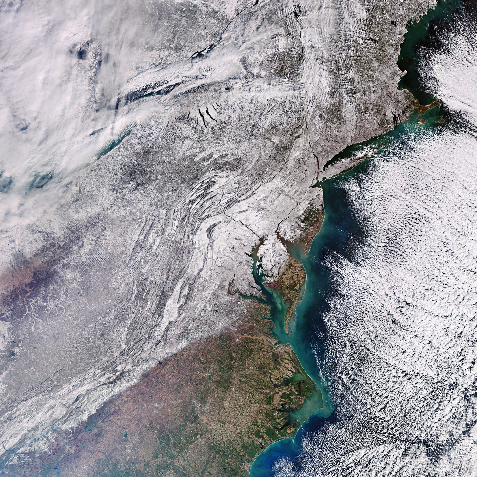
Earth from Space: Snow-bound eastern US [link]
"Record-breaking Arctic cold weather has swept through much of the United States in the last few weeks. The eastern part of the country was particularly affected with thick snow blanketing most of the region, as this Copernicus Sentinel-3 image shows."
Saharan Dust Blows Toward Europe [link]
"A large plume of dust from the Sahara Desert blew west over the Atlantic Ocean and then curled north toward Europe in late January 2024. Along its path, the suspended particles brought haze and poor air quality to Cabo Verde and the Canary Islands. Some of the dust that reached the United Kingdom mixed with clouds and fell to the ground with passing rain.
This animation shows the progression of the dust from January 24 to January 28. The images were acquired by the VIIRS (Visible Infrared Imaging Radiometer Suite) sensor on the NOAA-20 satellite. A large dust cloud expanded to the west over the ocean on January 24 and 25 before being redirected by strong southerly winds."
Related:

Meteosat captured a large plume of Saharan Dust travelling north across the Atlantic towards Europe [link]
Interesting reads
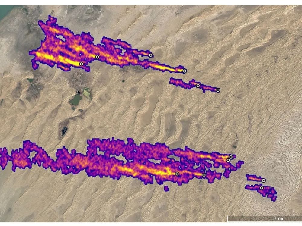
Not Invisible Anymore: Satellites reveal sources of atmospheric methane [link]
"Turkmenistan’s decision to sign the Global Methane Pledge, a voluntary agreement to slash methane emissions, was particularly gratifying for the people behind NASA’s Earth Surface Mineral Dust Source Investigation, known as EMIT.
Information from the NASA Jet Propulsion Laboratory’s EMIT imaging spectrometer mounted on the International Space Station and other sensors are helping Turkmenistan pinpoint the sources of leaks that made the Central Asian nation the world’s fourth highest methane emitter."