Level-2 News
Albedo raises $35 million for commercial very low Earth orbit constellation [link]
"Albedo raised $35 million to build and launch its first high-resolution Earth-imagery satellite.
The Series A-1 investment round, led by Standard Investments, brings the Earth-observation startup’s total funding to $97 million.
The investments announced Jan. 23 will accelerate deployment of Albedo’s very low Earth orbit (VLEO) constellation. Albedo aims to “ultimately prove out and proliferate the world’s first high-resolution VLEO platform,” Albedo CEO Topher Haddad told SpaceNews by email."
Synspective Signs New SAR Contracts in Central Asia [link]
"Synspective is increasing its reach into key Central Asian markets. The Japanese SAR satellite data and analytics solution provider has entered into MoUs with Uzbekistan’s Center for Space Monitoring and Geoinformation Technologies and Kazakhstan Gharysh Sapary (KGS), the national space agency of Kazakhstan. Synspective announced the MoUs, Jan. 25."
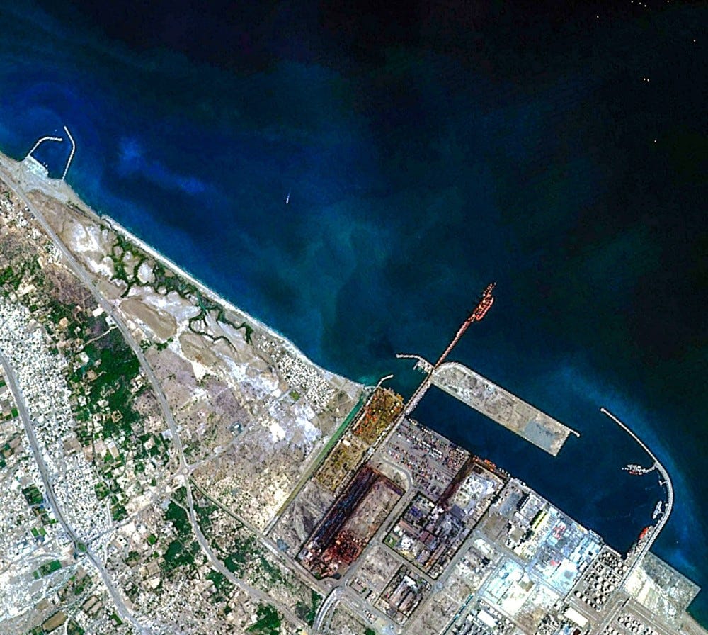
Oman’s Debut Satellite Releases First Images [link]
"Omani company Etco Space launched its first satellite, the Aman-1 in November 2023. The satellite has captured its first images of Sohar Port and a mountainous range of the Western Hajar Mountains from Low Earth Orbit (LEO)."
Capella Space, Floodbase Partner for High-Resolution SAR Data [link]
"Capella Space announced a partnership with Floodbase to bring high-resolution SAR satellite data to Floodbase’s end-to-end solution for parametric flood insurance.
This partnership will enable enhanced payout trigger certification of parametric insurance products by capturing the magnitude of flooding at high resolution and regardless of cloud cover."
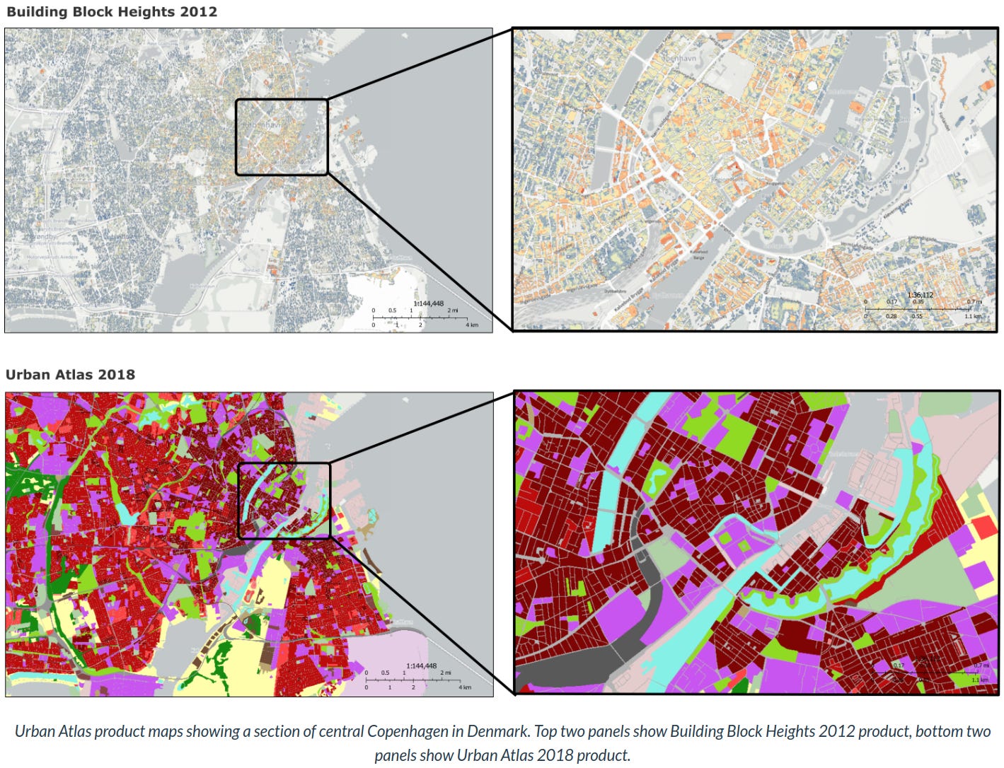
The Copernicus Land Monitoring Service (CLMS) signs new Urban Atlas contract [link]
"Among the project's main goals is to update the Urban Atlas data layers for 2021 and 2024. These updates represent a significant upgrade in the availability and frequency (from every 6 years to every 3) of new information related to urban land use, which is essential for the monitoring and planning of land-use policies. The key deliverables include new status and change layers for Urban Atlas and Building Block Heights, as well as the introduction and testing of a new product known as Green Land Use, which will allow users to distinguish between public and private green spaces."
Developer’s Orbit
Layover, shadows, and echo superposition in radar images… from a 3D terrain description [link]
Follow this post by Elise Colin as she codes her way into gaining a better undestanding of how relief terrain appears in a radar image and the effects of shadows and superimposed echoes.
PyGMTSAR (Python InSAR) 2024 Release [link]
"This new version of the open-source Python InSAR processor for Sentinel-1 SLC data includes SBAS, PS, and PS-SBAS-PS analyses with the state-of-the-art 1D SBAS pairs unwrapping for PS interferometry and powerful stratified and turbulent phase computing.
The new PyGMTSAR includes an ASF tool to download Sentinel-1 subswaths GeoTIFF files from complete Sentinel-1 SLC scenes zip archive on the Alaska Satellite Facility (ASF) datastore. Beyond that, it is fast enough to process thousands of interferograms even on the Google Colab Pro online environment! You can find the Google Colab examples on GitHub."
cubo; On-Demand Earth System Data Cubes (ESDCs) in Python [link]
cubo v2024.1.0 can create cubes fromGoogleEarthEngine in addition to STAC catalogues!
Data

The Top 11 Open GeoParquet Datasets: Making big geospatial data easy [link]
Matt Forrest has compiled a list consisting of 11 of the best free GeoParquet datasets to analyze big geospatial data.
Snapshots

Earth from Space: Columbia Glacier, Alaska [link]
The Columbia Glacier, visible just above the middle of the image, is a tidewater glacier that flows down the snow-covered slopes of the Chugach Mountains, which dominate the upper part of the image. The mountains hold Alaska’s largest concentration of glacial ice.
Since the early 1980s, the Columbia Glacier has retreated more than 20 km and lost about half of its total volume. This one glacier accounts for nearly half of the ice lost in the Chugach Mountains.
World’s largest iceberg drifts beyond Antarctic waters [link]
"In November 2023, the A23a mega iceberg set sail after being grounded on the ocean floor for well over 40 years. Now, driven by winds and currents, A23a is heading away from Antarctic waters as seen in this new animation."
New Fissures Spill Lava in Iceland [link]
"Volcanic activity reawakened on the Reykjanes peninsula in southwestern Iceland with a pulse of eruptions in mid-January 2024. Over the course of about two days, new fissures released lava near the town of Grindavík. A human-constructed barrier diverted some of the flow from one fissure away from town, but lava from one closer to Grindavík engulfed several homes. The eruption occurred less than a month after another fissure opened several kilometers to the northeast. It was the fifth eruption on the peninsula since 2021."
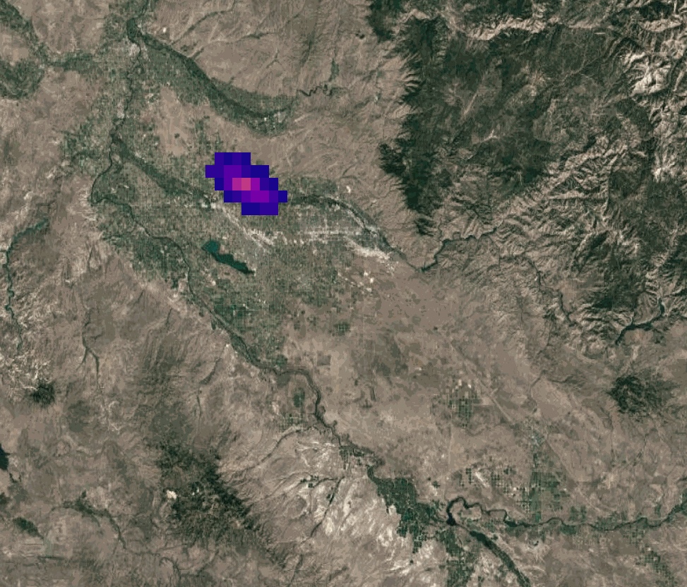
Tracking a methane plume in Ohio [link]
By analysing imagery from geostationary climate satellite GOES-16, Kayrros tracked the entire lifecycle of a largemethane plume in Ohio, from its October "birth," when a farmer accidentally struck a natural gas pipeline, to its subsequent dispersion, some 75 miles downwind, five hours later.
Interesting reads
Earth Observation CEOs Analyze 2023, a Seismic Year in EO [link]
"Via Satellite talks to some of the biggest companies in the Earth Observation (EO) market and discusses what the big stories were of 2023, and what they expect to see in 2024.
Taking part in the round table are: Susanne Hake, general manager of U.S. Government for Maxar Intelligence; Theresa Condor, COO of Spire Global, Awais Ahmed, CEO of Pixxel; Paolo Minciacchi, CEO of e-GEOS; and Anders Linder, general manager of International Government for Maxar Intelligence."
Weather forecasting, from space to your smartphone [link]
I often say that weather forecasting is the success story of Earth Observation; a seamless integration - from observations to actionable insights and practical applications and into billions of devices. So seamless, that many people don’t even know that weather forecasts are only possible thanks to satellites.
As the Meteorological Operational Second Generation (MetOp-SG) satellites are being built by Airbus for the European Space Agency (ESA) and EUMETSAT, this article highlights the importance of satellite for accurate weather foresasts and the challenges of forecasting.
"The planned MetOp-SG A1 and B1 satellite launches in 2025-2026 will ensure continuity with the current MetOp fleet, without a gap."
They Abducted a River in California. And Nobody Stopped Them [link]
This story raises questions about the state’s ability to manage supplies during drought. According to reports, California’s water board doesn’t have the staff it would need to monitor river levels statewide.
This situation is ideal for utilizing EO data…
Space Crafts [link]
Note: This is not very relevant to the content usually published here, but I’ve recently watched this video and I just had to find out more…!
"Three craft-loving women swapped their sewing patterns and glue guns to take on an out-of-this-world job opportunity, and are now helping to make thermal blankets for satellites."
Upcoming Events
Natural Disaster Management: Using AI for Rapid Building Damage Assessment [link]
"Artificial intelligence can help authorities rapidly assess the extent of damage to buildings after disasters, enabling organizations to target their efforts to deliver critical aid.
In this webinar, we’ll show how Microsoft’s AI for Good Lab used Planet data to accelerate and target response efforts following the February 2023 earthquake in Turkey and the August 2023 wildfire in Lahaina, Hawaii."
Learning
Big Data from Space (BiDS'23) recordings are available [link]
BiDS 2023 Plenary Sessions [link]
BiDS 2023 Satellite Events [link]
Proceedings of the 2023 conference on Big Data from Space (BiDS’23) [link]
Spatial Data Management with Google Earth Engine [link]
Qiusheng Wu’s course is now available on the United Nations University Open edX platform.
"The course is focused on cloud based management and visualization of geospatial data. It explores Google Earth Engine, a powerful cloud-based platform for analyzing geospatial data at scale."
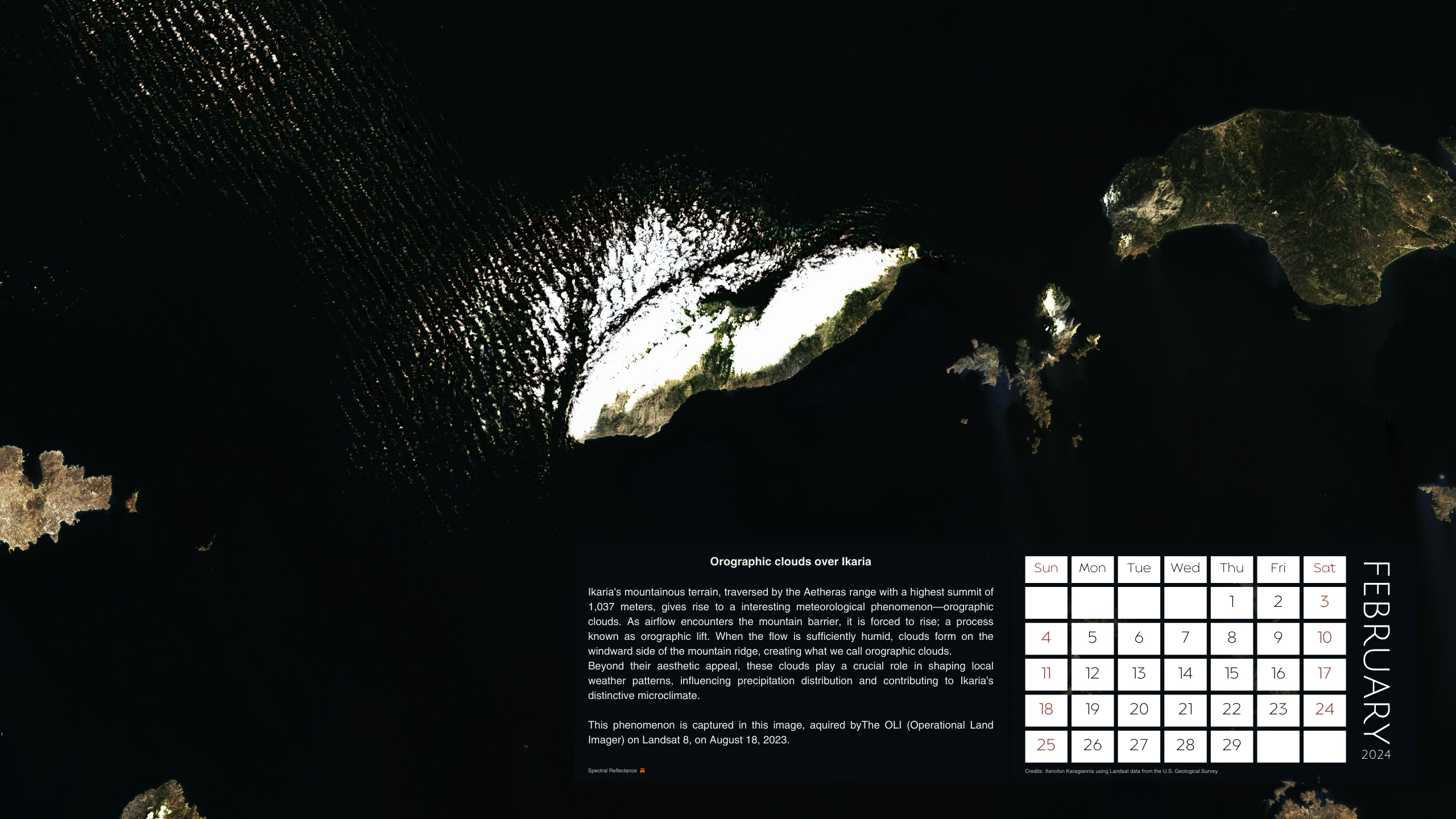
Spectral Reflectance 2024 Calendar
February 2024: Orographic clouds over Ikaria [link]