

Level-2 News
New ESA Environmental Security Project Goes Live [link]
"A new European Space Agency (ESA) project to fight environmental crime and monitor illegal activities is now fully operational. The project, EO4Security, is dedicated to developing algorithms and application platforms designed to provide tools capable of delivering timely geoinformation on noncompliance with environmental regulations, such as illegal mining and irregular trafficking."
Developer’s Orbit
Searching and downloading NASA Earth science data products with Leafmap [link]
NASA hosts over 9,000 Earth data products on AWS!
Discover how to effortlessly search and download them in this leafmap tutorial.
Interactive Exploration of EMIT Mission Data [link]
This Pangeo Showcase Presentation by Erik Bolch demonstrates creating an interactive map linked to a per-pixel spectral plot that can be used to explore the surface reflectance at different locations."

How we’re making it easier to work with open climate data [link]
People at CarbonPlan used several of tools in the Pangeo Ecosystem, such as Kerchunk, Xarray-Datatree and Coiled/Dask to speed-up part of their work on modeling extreme heat in a changing climate.
Data

Emergency Observation Data for the 2024 Sea of Japan Earthquake from JAXA now available in the Awesome GEE community catalog [link]
"The 2024 Sea of Japan earthquake occurred on January 1, 2024, after 4:00 PM (Japan time), resulting in significant damage, including building collapses, landslides, and fires at various locations. In response to requests from domestic disaster prevention agencies, JAXA conducted emergency observations using ALOS-2 from the night of the disaster. The released data includes Level 2.1 (GeoTIFF) and archive data, facilitating interference analysis and change detection to contribute to disaster reduction and prevention."
GEE Community Catalog [link]
Snapshots
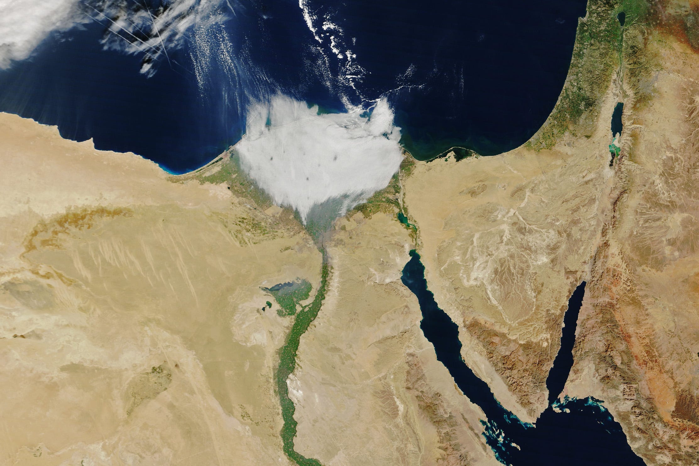
Foggy Nile [link]
"In satellite images, the Nile Delta in northern Egypt usually looks like a lush green flower blooming amidst the browns of the surrounding desert.
But when the MODIS (Moderate Resolution Imaging Spectroradiometer) on NASA’s Terra satellite passed over the feature on the morning of January 7, 2024, the delta was blanketed with a layer of low clouds, making it look more like a tuft of cotton."
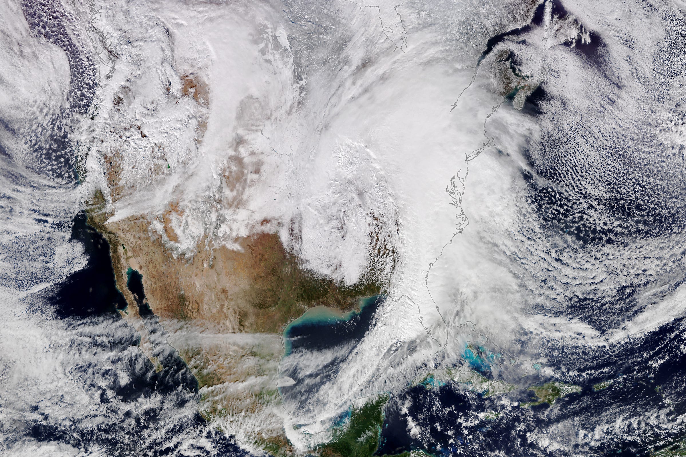
Winter Storm Wallops the U.S. [link]
"A potent winter storm plowed across the eastern half of the United States on January 9, 2024, delivering heavy rain and snow, strong winds, and damaging tornadoes. That afternoon, the VIIRS (Visible Infrared Imaging Radiometer Suite) on the NOAA-20 satellite acquired this natural-color image (above) of the sprawling storm clouds."
Interesting reads
'Cryptogram' in a silk dress tells a weather story [link]
"Sometimes a dress is just a dress. In this story, a dress becomes a kind of time travel portal, where we get to return very briefly to the Industrial Revolution and learn about the history of weather forecasting on the frontiers of North America in the 1800s."
Related:
An Antique Dress Held a Secret: A Coded Message From 1888 [link]
Breaking the Silk Dress cryptogram [link]
Insights into waterborne infectious diseases with Earth Observation [link]
"There is an increasing threat from water-related issues impacting the human population through global warming, shifts in precipitation patterns and extreme weather conditions, all leading to water stress, including natural disasters such as floods or droughts, with a risk of severe damage to the environment, property and human life. A less studied aspect of such events is their impact on human health through waterborne diseases.
The ESA-funded project Waterborne Infectious Diseases and Global Earth Observation in the Nearshore (WIDGEON) provided a perspective on the capabilities of remote sensing to build capacity and resilience against waterborne diseases under extreme weather conditions in coastal regions."
This US-Indian Satellite Will Monitor Earth’s Changing Frozen Regions [link]
"NISAR will study changes to ice sheets, glaciers, and sea ice in fine detail, as climate change warms the air and ocean.
Short for NASA-ISRO Synthetic Aperture Radar, NISAR will provide the most comprehensive picture to date of motion and deformation of frozen surfaces in Earth’s ice- and snow-covered environments, collectively known as the cryosphere."
Upcoming Events
 in Celsius compared to the 1951-1980 average. Most of the globe is yellow, orange and red, indicating that Earth was hotter than average in 2023.")
NASA, NOAA to Announce 2023 Global Temperatures, Climate Conditions [link]
Climate researchers from NASA and NOAA (National Oceanic and Atmospheric Administration) will release their annual assessments of global temperatures and discuss the major climate trends of 2023 during a media briefing at 11 a.m. EST Friday, Jan. 12.
NASA will stream audio of the briefing on the agency’s YouTube.
Call for Papers

EarthVision will be again at CVPR this year [link]
"The aim of EarthVision to advance the state of the art in machine learning-based analysis of remote sensing data. It also connects to other immediate societal challenges such as monitoring of forest fires and other natural hazards, urban growth, deforestation, and climate change."
Submission deadline: March 8, 2024