Level-2 News
SynMax Raises $13M for its industrial sites monitoring and dark ships detection platforms [link]
"SynMax, a satellite data analytics company building products to monitor industrial assets and dark ships around the globe, has raised a $13M round of funding as it eyes new markets for its analysis platforms."
GAO denies L3Harris protest over Ball Aerospace weather satellite instrument contract [link]
"The Government Accountability Office has rejected a protest filed by L3Harris over NASA’s award of a contract to Ball Aerospace for a next-generation weather satellite instrument."
Maxar wins contract to provide 3D imagery of Indo-Pacific region [link]
"Maxar Technologies announced Jan. 4 it secured a contract from the National Geospatial-Intelligence Agency (NGA) to provide advanced satellite imagery and data for 3D maps and models.
Maxar will provide a 3D data bundle covering 160,000 square kilometers within the U.S. Indo-Pacific Command area of responsibility."
Sidus Space Receives NOAA Remote Sensing License [link]
"Sidus Space has received a Tier 1 remote sensing license from the National Oceanic and Atmospheric Administration (NOAA) for panchromatic (PAN) and shortwave infrared (SWIR) imaging capabilities.
This license allows Sidus satellites to collect and distribute images and data to government and commercial customers. The company plans to collect PAN and SWIR imaging, which will be processed by its FeatherBox artificial intelligence onboard processor. The AI processor will integrate the images with automated information systems (AIS) and GPS data to inform on marine traffic trends, illegal fishing activities, methane emission locations and quantities, and vegetative stress on crops."
NHAI signs MoU with NRSC for Development of Green Cover Index [link]
"Using the capabilities of emerging technologies to enhance in-situ data collection and supplement plantation management and monitoring, including performance audits conducted by National Highways Authority of India (NHAI), the National Remote Sensing Centre (NRSC) will undertake a comprehensive pan-India estimation of green cover, referred to as the “Green Cover Index” for National Highways using high-resolution satellite imagery."
Developer’s Orbit

Create 3D Forest Type Maps with rayshader in R [link]
"In this video, you will learn how to create wonderful 3D forest-type maps with rayshader in R.
Milos Popovic creates a 3D elevation mapped overlayed with an image of forest-type values derived from the Copernicus Global Land Cover project, which provides a harmonized and high-resolution classification and mapping of land cover types across the globe."
SpatioTemporal Asset Catalog (STAC) For The Rest of Us [link]
Follow this article by Emmanuel J., who documented the resources he used while working with STAC.
LISS4 Image Processing using XArray and Dask [link]
"ISRO recently released the full archive of medium and low-resolution Earth Observation dataset to the public.
This post on spatialthoughts covers the steps required to download the imagery from the LISS-IV camera aboard ResourceSat-2 and ResourceSat-2A satellites and apply the pre-processing steps required to make this data ready for analysis – specifically how to programmatically convert the DN values to TOA Reflectance."
Data
Sensor-Independent MODIS/VIIRS LAI/FPAR dataset joins the Awesome GEE Community Catalog! [link]
"This geospatial dataset encompasses crucial biophysical parameters, namely Leaf Area Index (LAI) and Fraction of Photosynthetically Active Radiation (FPAR), indispensable for characterizing terrestrial ecosystems."
"Spanning from 2000 to 2022, this dataset offers varying resolutions and comprehensive coverage, making it a go-to tool for researchers worldwide."
Paper:
Sensor-independent LAI/FPAR CDR: reconstructing a global sensor-independent climate data record of MODIS and VIIRS LAI/FPAR from 2000 to 2022 [link]
Snapshots

Cloud Streets Over the Sea of Okhotsk [link]
"Cloud streets develop in the troposphere when cold, dry air from land moves over the comparatively warm ocean and gains moisture. Where the warm, moist air rises, water vapor condenses to form clouds. Where cooled air sinks adjacent to the clouds, skies are clear. Cloud streets, also known as horizontal convective rolls, are oriented in line with the direction of the wind."
Interesting reads
The value of open data [LinkedIn thread]
In this post on LinkedIn, Joe Morrison, VP of Commercial Experience at Umbra, showcases two instances where people leveraged Open Data provided by Umbra, emphasizing the significance of Open Data and the value derived from it.
Explore:
Umbra Synthetic Aperture Radar (SAR) Open Data; STAC Catalog on AWS [link]
Measuring how space creates jobs and prosperity on Earth [link]
"Space is becoming ever more important to life on Earth – from managing climate change to responding to emergencies to digitalising the economy. To help policymakers and businesses take informed decisions about investing in space, ESA has published plans to create robust and reliable data on the space economy, in collaboration with international partners."

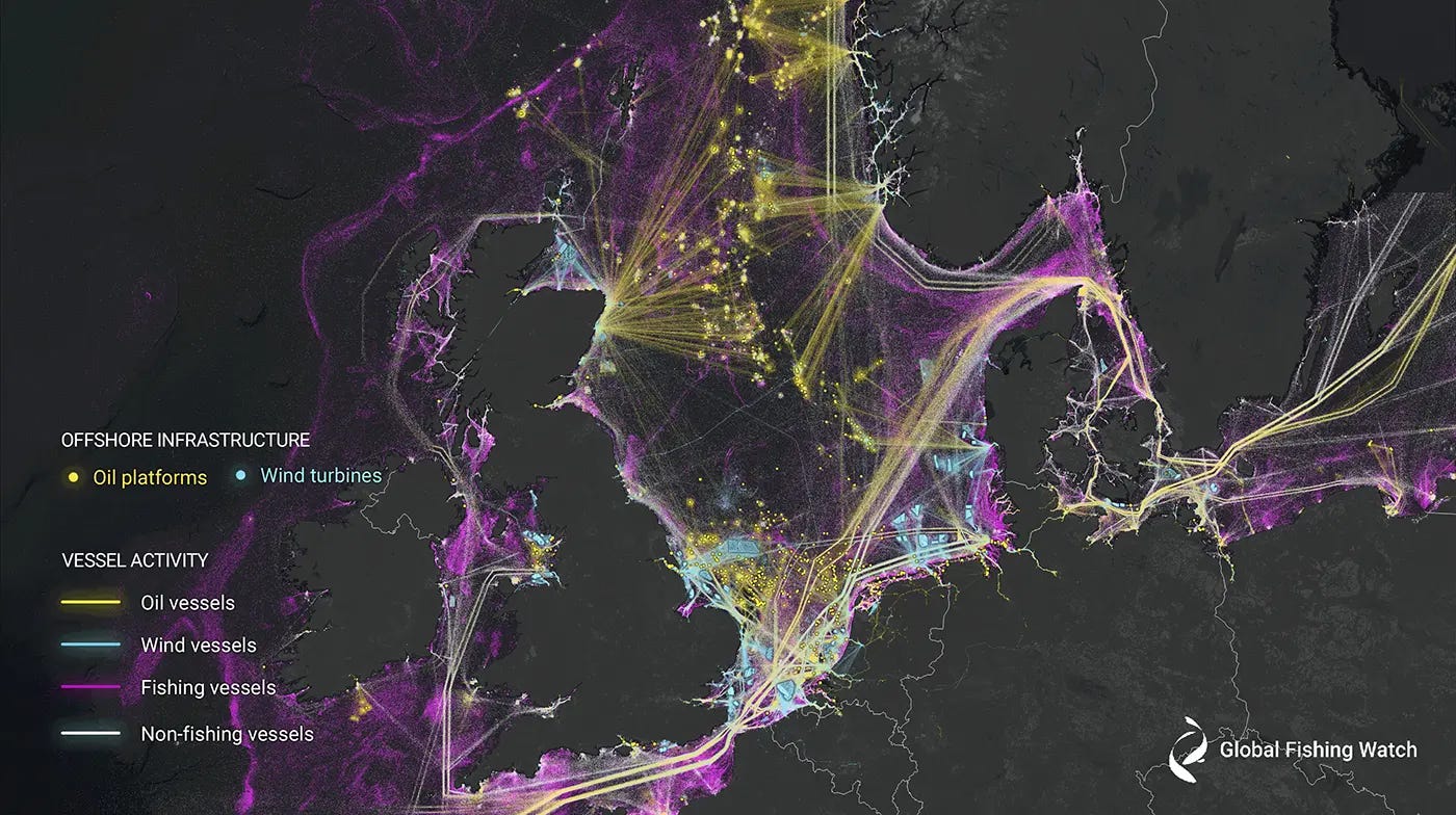
New research harnesses AI and satellite imagery to reveal the expanding footprint of human activity at sea [link]
"A new study published a few days ago in the journal Nature offers an unprecedented view of previously unmapped industrial use of the ocean and how it is changing.
The study, led by Global Fishing Watch, uses machine learning and satellite imagery to create the first global map of large vessel traffic and offshore infrastructure, finding a remarkable amount of activity that was previously “dark” to public monitoring systems.
By synthesizing GPS data with five years of radar and optical imagery, the researchers were able to identify vessels that failed to broadcast their positions. Using machine learning, they then concluded which of those vessels were likely engaged in fishing activity.
The findings reveal that 75 percent of the world’s industrial fishing vessels are hidden from public view."
Upcoming Events
2024 Events for the Climate Data from Space Calendar [link]
A non-exhaustive list of climate satellite data events in 2024.
Internships
6-to-8-months internship at Planet [link]
"In this internship, you will collaborate with the engineers and product manager of the Land Surface Temperature (LST) team, as well as scientists from Planet’s Earth Observation Lab (EO-Lab) led by Dr. Richard De Jeu."
Recently on Spectral Reflectance
Learning
The recording of the 4-hr EarthEngine and geemap workshop at AGU23 is now available [link]


