

Level-2 News
HotSat-1: UK climate satellite suffers failure in orbit [link]
"An innovative UK climate satellite has failed in orbit just six months after launch.
HotSat-1 was put up to map heat loss from buildings and was doing so successfully until its camera stopped working earlier this week.
SatVu, the London company behind the mission, does not expect to restore operations even though engineers are still in contact with the spacecraft.
The satellite was fully insured and a replacement will be flown in 2025."
Three Satellites Failed to Deploy from Transporter-9 [link]
"It turns out Transporter-9 deployment didn’t go as smoothly as planned for some passengers. Momentus ($MNTS) announced last week that three of the five satellites it had carried failed to deploy from the third-party deployer it used for the mission, and are now presumed lost."
Two of them were EO satellites:
1. The AMAN-1 EO satellite for Poland’s SatRev
2. JINJUSat-1, an EO satellite for South Korea’s CONTEC
Eumetsat Contracts Spire for Satellite Weather Data [link]
"Europe’s meteorological satellite agency Eumetsat has awarded Spire Global a contract to provide radio occultation (RO) data. Spire will provide the data in near-real time, and it will be distributed to the Eumetsat user community globally for use in weather forecast modeling.
The contract is for an initial period of two years, from 2024 to 2026, with three optional, one-year extensions. Financial terms of the deal were not disclosed."
Malaysian Energy Company Uzma Taps Satellogic to Further Geospatial Ambitions [link]
"Satellogic has won a major new deal with Malaysian energy company Uzma to advance geospatial capabilities in Southeast Asia. The agreement, announced Dec. 7, includes leveraging an EO satellite designed and manufactured by Satellogic that is planned to be launched in the second half of 2024 as ‘UzmaSAT-1’ aboard a SpaceX Falcon 9 rocket."
Thales to Build Radar and Optical Constellation for Indonesian Defense Purposes [link]
"Thales Alenia Space will build an Earth observation constellation with radar and optical sensors for the Indonesian Ministry of Defence (MoD), under a deal announced Thursday. State-owned technology company PT Len awarded Thales the contract and will operate the Defense Satellite System for MoD sovereignty requirements.
The satellites will be built on the existing Thales radar and optical offering. Telespazio will contribute to the ground segment. In addition, PT Len will develop a multi-mission ground segment system to provide control, maintenance, data processing, and analytic functions for the Defense Satellite System."
Element 84 Awarded 2023 AWS Partner Award [link]
"Element 84 recognized as Aerospace and Satellite Partner of the Year winner, one of many AWS Partners around the globe that help customers drive innovation.
Geo and Global AWS Partner Awards recognize partners whose business models continue to evolve and thrive on AWS as they work with customers. Element 84 tackles some of Earth’s biggest problems by employing FilmDrop, a suite of open-source tools that ingests, archives, processes, analyzes, and distributes geospatial data in AWS."
Can the private sector plug the weather data gap? Space Force to launch new study [link]
"The U.S. Space Force will launch a new market research study next year to assess commercial weather services to fill some of the military’s ever-growing data needs. The move comes amid concerns that the military’s current reliance on a patchwork of international and domestic sources is inadequate for future operational demands."
Open Cosmos Launches Fourth Satellite for Telecom and EO constellations [link]
"Open Cosmos, a space company making satellites that gather data to solve pressing global challenges, has seen its fourth Earth Observation satellite of the year, ALISIO-1 launched.
The primary payload aboard ALISIO-1, DRAGO-2, is a unique compact uncooled and camera operating in the Short-Wave Infrared (SWIR) range, providing a unique vantage point invisible to the human eye.
This powerful tool will generate precise observations of the Canary Islands, as well as other regions around the globe, playing a vital role in various applications including wildfire monitoring, volcano activity monitoring, oil spill detection, desertification control & crop humidity among others."
Data
GLanCE: A Global Land Cover Training Dataset from 1984 to 2020 [link]
"The Global Land Cover Estimation (GLanCE) project provides high-quality long-term records of land cover and land cover change at 30 m spatial resolution for the 21st century using the Landsat archive.
The GLanCE land cover classification scheme is designed to be compatible with common land cover classification systems such as the IPCC land use categories for greenhouse gas inventory reporting and the FAO Land Cover Classification System (LCCS)."
Paper [link]
Dataset hosted on Source Cooperative [link]
Year in review
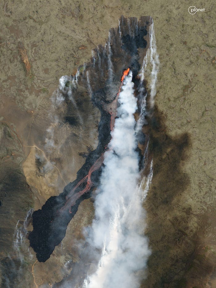
ESA’s Observing the Earth - Top 10 Earth observation stories of 2023 [link]
"This year has been a whirlwind of captivating Earth observation stories and news, spanning from dramatic volcanic eruptions to powerful earthquakes to witnessing icebergs on the run. Join us as we revisit some of the most memorable stories from 2023."
2023 in (Planet) Images [link]
Satellites from Planet’s Planetscope and Skysay constellations spent one more year orbiting-observing-monitoring.
Check out this year-in-review through a series of images from Planet.
openEO - Looking back on 2023 [link]
"It’s been a very busy year for openEO, taking part in various conferences, multiple training sessions and presentations all over Europe as well as on the international stage."
Check out their accomplishments!
Snapshots

"First Image" sent by Meteosat-1, 46 years ago [link]
"This meteorological satellite, part of a series of seven satellites (Meteosat First Generation - MFG) and operated by EUMETSAT (European Organisation for the Exploitation of Meteorological Satellites) beginning in Nov 1977 and concluded in 2017."
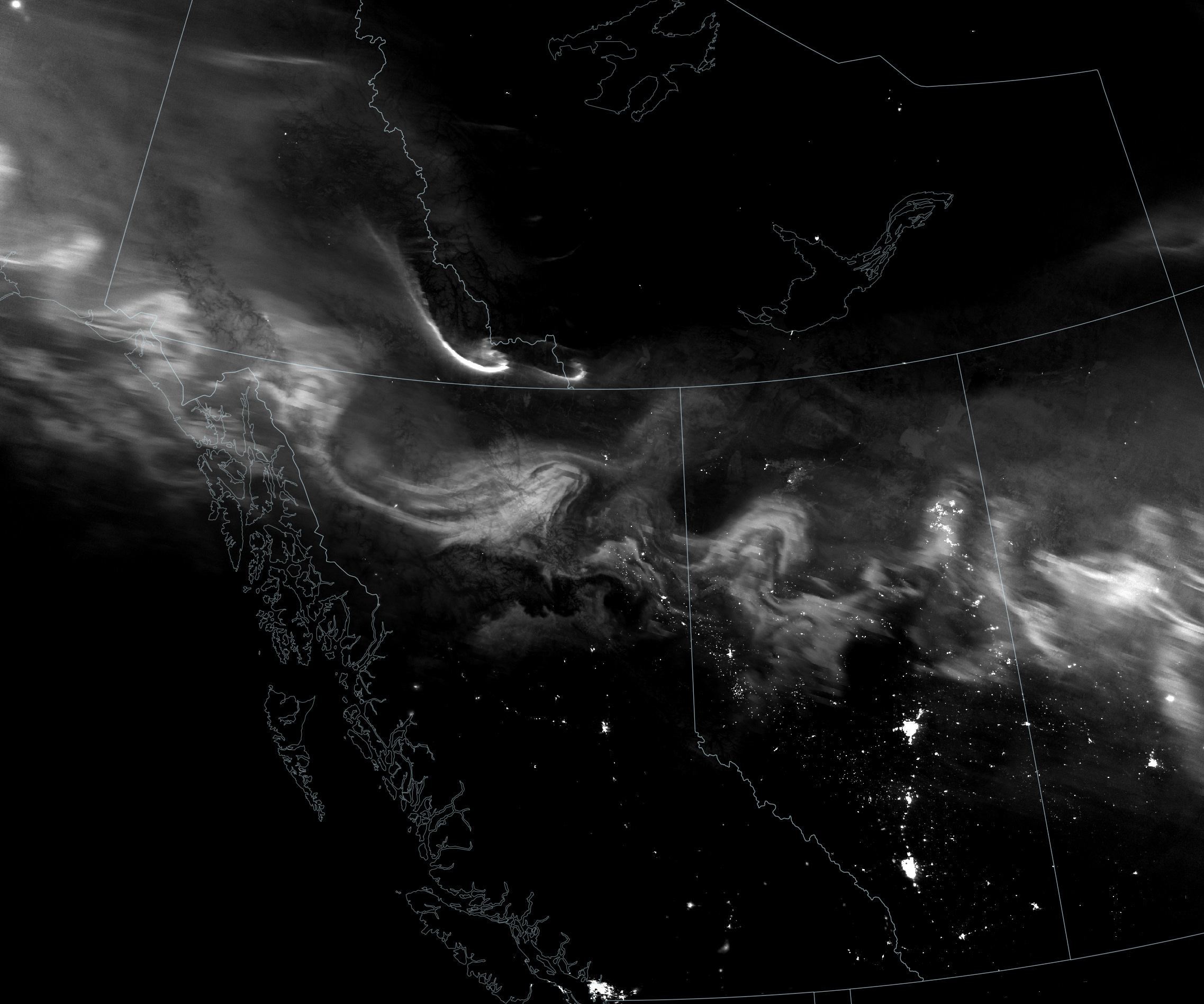
Auroras Light Up the North [link]
"A flurry of solar activity in mid-December 2023 sent energized particles crashing into Earth’s magnetosphere, producing undulating auroras across northern latitudes of our planet.
The day-night band of VIIRS detects nighttime light in a range of wavelengths from green to near-infrared and uses filtering techniques to observe signals such as city lights, reflected moonlight, and auroras."
Interesting reads

NASA Sensor Produces First Global Maps of Surface Minerals in Arid Regions [link]
"NASA’s EMIT mission has created the first comprehensive maps of the world’s mineral dust-source regions, providing precise locations of 10 key minerals based on how they reflect and absorb light. When winds loft these substances into the air, they either cool or warm the atmosphere and Earth’s surface, depending on their composition. Understanding their abundance around the globe will help researchers predict future climate impacts.
To date, the mission has captured more than 55,000 “scenes” – 50-by-50-mile (80-by-80-kilometer) images of the surface – in its study area, which includes arid regions within a 6,900-mile-wide (11,000-kilometer-wide) belt around Earth’s mid-section. Taken together, the scenes comprise billions of measurements – more than enough to create detailed maps of surface composition."

Monitoring Large-scale Landslides Using Sentinel-2 Derived Products [link]
Discover in this web-story how EO data provided in the DigitalTwin of Alps is used to document landslide motion over La Valette (France) and La Barmasse (Switzerland).
NASA’s Earth Observatory has published more than 12,490 image-driven stories [link]
"Founded in 1999 by NASA, the Earth Observatory set out on an ambitious mission: to bring images, stories, and discoveries about our planet to the world.
As of December 2023, the Earth Observatory has published more than 12,490 image-driven stories. This number grows daily and includes satellite images, photographs taken by astronauts, and visualizations from scientific studies. Each of these graphics and stories has been cataloged in their interactive map, EO Explorer."
NASA Helps Study One of the World’s Most Diverse Ecosystems [link]
"An international team of researchers spent October and November 2023 in the field studying one of the world’s most biologically diverse areas – South Africa’s Greater Cape Floristic Region. As part of the effort, researchers used NASA airborne and space-based instruments to gather complementary data to better understand the unique aquatic and terrestrial ecosystems in this region. Their findings will inform the capabilities of future satellite missions aimed at studying plants and animals."
Climate Change Threatens Australia’s Low-lying Coral Reef Islands [link]
"University of Sydney researchers have found 25 percent of Australia’s coral islands, land masses formed by reefs, currently face high to very high risk of being wiped out by climate change.
The research introduces an innovative method to evaluate and categorise coral reef islands based on their risk from and resilience to climate change.
The risk system, built using open-access ocean climate data and satellite imagery that could be applied globally, provides decision-makers with a tool to prioritise protection efforts for vulnerable coral islands in the era of rapid climate change."
Permafrost thaw: a silent menace [link]
"Ice is without doubt one of the first casualties of climate change, but the effects of our warming world are not only limited to ice melting on Earth’s surface. Ground that has been frozen for thousands of years, called permafrost, is thawing – adding to the climate crisis and causing serious issues for local communities."