

Level-2 News
Satellogic gets NOAA license for move to the United States [link]
"Satellogic has received a remote sensing license in the United States, the Earth observation operator announced Nov. 21 as it moves operations to the country from Uruguay in search of more government business.
The license allows Satellogic to pursue more opportunities for contracts and partnerships with US military and civil agencies, a key area of growth for the company’s remote sensing data."
UK Looks to Join the Atlantic Constellation with Open Cosmos Satellite [link]
"The UK Space Agency is providing 3 million pounds ($3.75 million) to support a pathfinder satellite, intended to be one of the first in the constellation, with co-funding from Open Cosmos, based on the Harwell Space Campus in Oxfordshire. The commitment was announced on the opening day of the UK Space Conference in Belfast, Northern Ireland."
Recently launched Planet satellites now imaging [link]
Planet’s CEO, Will Marshall, reported that the latest batch of SuperDoves, recently launched onboard SpaceX’s Transporter-9, are now imaging.
And the Pelican-1 tech demo is also comissioning new imagery!
NASA and Japan to Launch World’s First Wooden Satellite in 2024 [link]
"NASA and the Japan Aerospace Exploration Agency (JAXA) are poised to launch the world’s first wooden satellite, dubbed LignoSat, into orbit as early as 2024.
This innovative project aims to tackle the growing issue of space debris by utilizing a renewable and biodegradable material that will significantly reduce the environmental impact of spacecraft re-entry.
In the vacuum of space, wood exhibits remarkable stability, neither burning nor rotting. However, upon re-entry into Earth’s atmosphere, it will incinerate into a fine ash, leaving behind no harmful debris. This unique property makes wood an environmentally friendly material that poses no risk to the planet."
Blackshark.ai Raises $35 Million to Transform Geospatial Data Analysis [link]
"With this latest funding, blackshark.ai is looking to advance its mission of expanding its 3D high-frequency mapping and geospatial intelligence capabilities.
At the core of blackshark.ai’s innovation is a platform that transforms massive volumes of raw data from satellite and aerial imagery into semantically labeled geospatial Digital Twins."
Satellite Images Capture Mass Exodus of Palestinians from Gaza [link]
"European Space Imaging (EUSI) partner Maxar, a global provider of high-resolution satellite imagery and geospatial data collected new satellite imagery on November 17th at 11:31 AM local time.
The images show a large crowd of people gathered along Salah al Deen Road in southern Gaza. These individuals are attempting to flee south along the evacuation corridor."
Powering climate action through Earth observations technology [link]
"The UN Climate Change Technology Executive Committee (TEC) has joined forces with the Group on Earth Observation (GEO), under the Early Warnings for All initiative, to assist vulnerable countries in using Earth observations technology for the design of climate policies and adaptation projects."
Data
TanDEM-X 30-metre DEM Change Map; Topographic changes on Earth measured [link]
The German Aerospace Center (Deutsches Zentrum für Luft- und Raumfahrt; DLR) has established another milestone in 3D Earth mapping with the 'TanDEM-X 30-metre DEM Change Map', which provides a global overview of changes to Earth's surface. Change maps are relevant for everything from glacial retreat to agricultural development, volcanic activity and urban planning. Mapping changes in this way is significant for numerous research fields, climate change studies and socio-political issues.
The new dataset from the TanDEM-X satellite mission is now freely available at a pixel spacing of 30 metres, with an absolute height accuracy down to just one metre, providing high-precision data across the globe. [link]
Monitor changes in sea ice formations with a free dataset from ICEYE [link]
"The dataset includes a pair of images covering a 10,000 km² area of the Hudson Strait, Canada."
Snapshots
Swirls in the Sky and Sea [link]
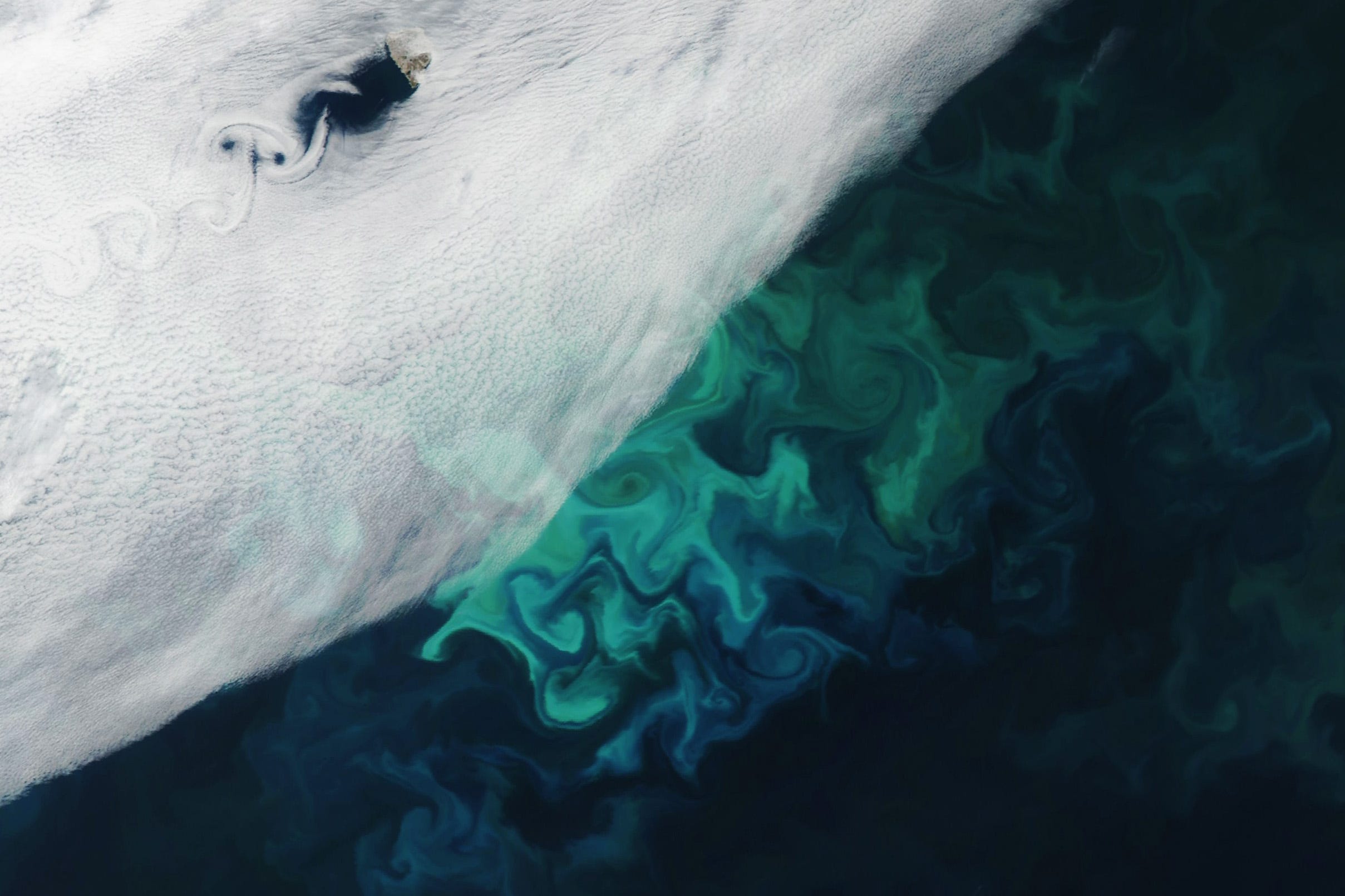
"Theodore von Kármán, a Hungarian-American physicist, is well-known within NASA for helping found the Jet Propulsion Laboratory. But in atmospheric science circles he is most celebrated for his research on fluid turbulence and his pioneering work on a phenomenon that came to be known as von Kármán vortices.
Von Kármán vortices appear as long linear chains of spiral eddies and can develop nearly anywhere that fluid flow is disturbed by an object. The atmosphere behaves like a fluid, so the wing of an airplane, a bridge, and even an island can cause the vortices to form.
In this image, remote Bear Island (also called Bjórnóya)—the southernmost island of Norway’s Svalbard archipelago—helped trigger the spiraling cloud pattern."
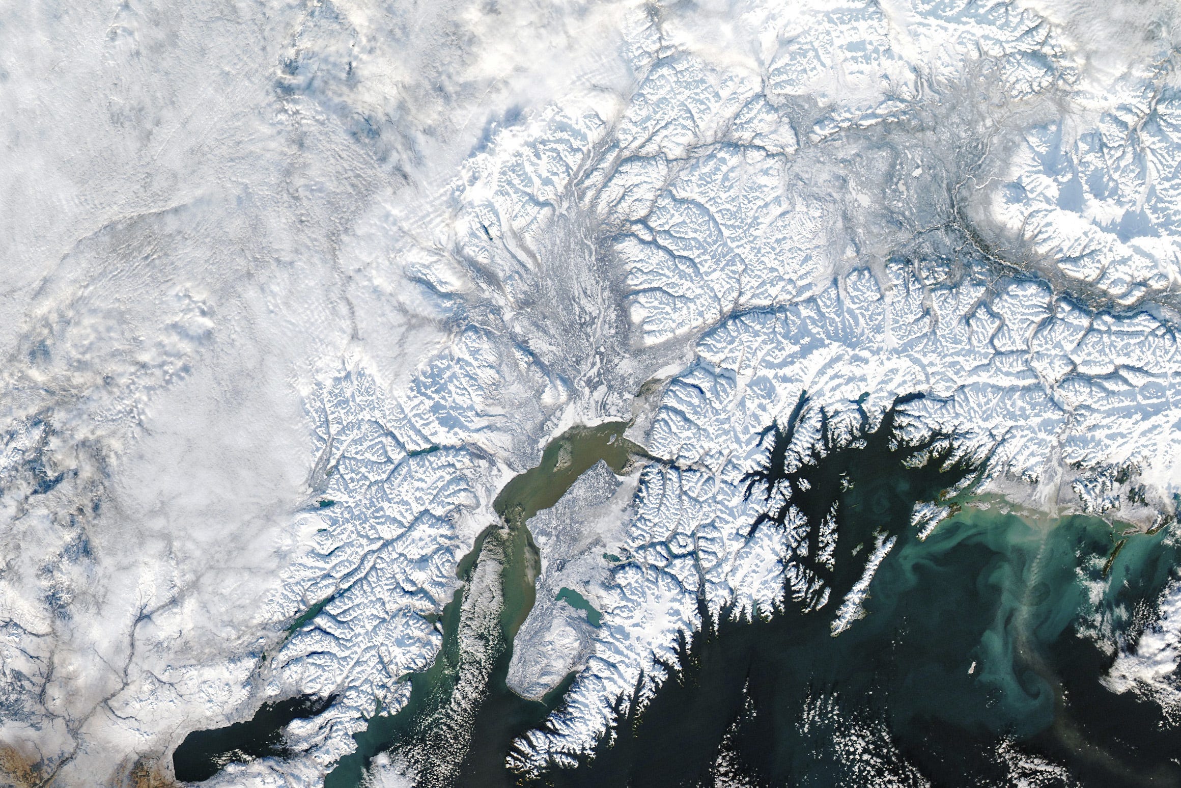
Anchorage Blanketed in Snow [link]
"Winter weather arrived in force in Southcentral Alaska in 2023. Anchorage logged its snowiest November since recordkeeping began in 1953—and it reached that mark just over halfway through the month. In addition, a nearby mountain pass came close to the national record for 24-hour snowfall."
A Small Green Iceberg? [link]
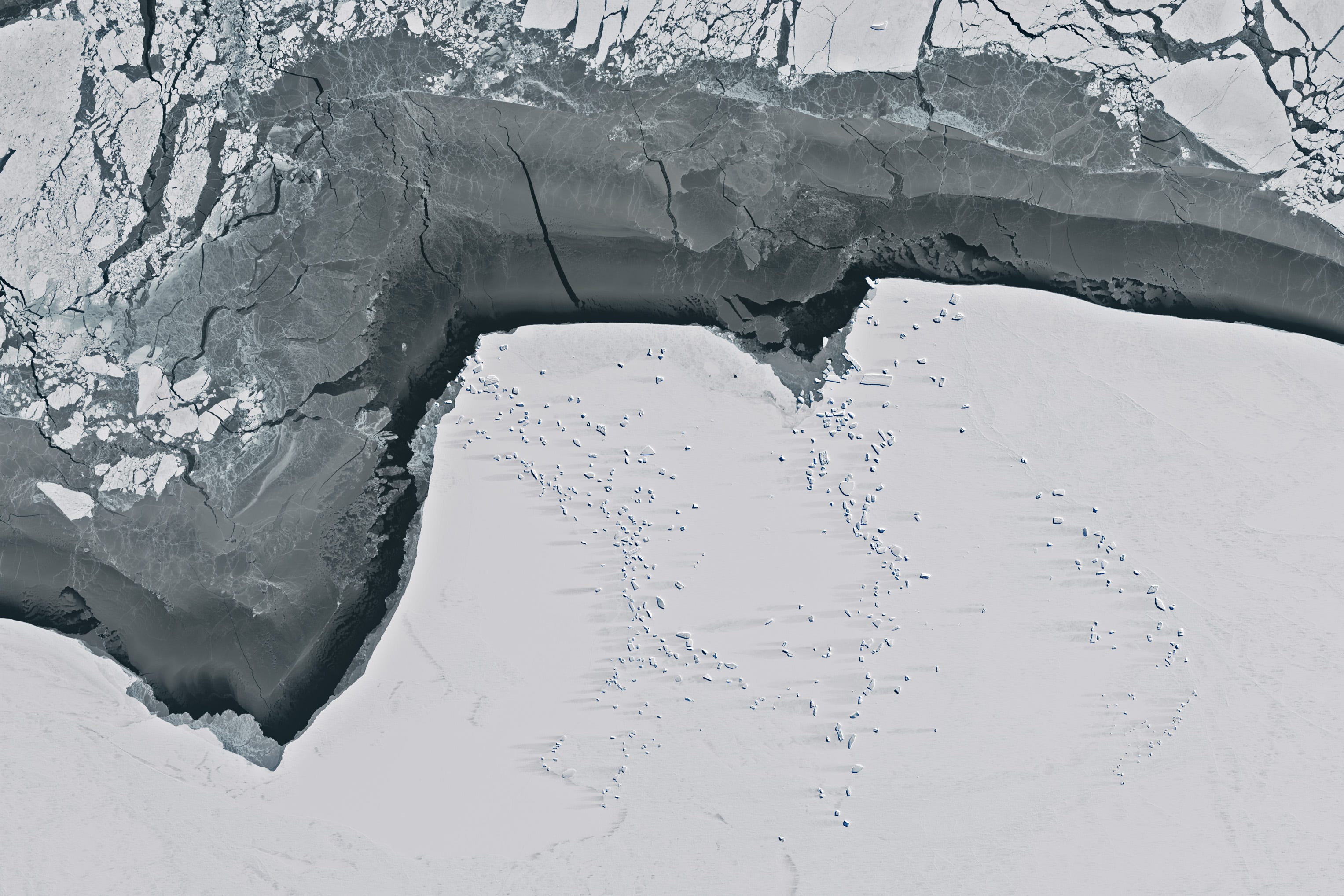
"Jan Lieser has analyzed countless satellite images of frozen seawater clinging to the coast of East Antarctica. This ice—known as landfast ice or simply fast ice—regulates the seaward flow of land ice and provides habitat for animals. The ice’s textures can be varied, but its colors are mostly grayscale. In October 2023, something green caught his eye."
Interesting reads

NASA Mission Excels at Spotting Greenhouse Gas Emission Sources [link]
"Since launching 16 months ago, the EMIT imaging spectrometer aboard the International Space Station has shown an ability to detect more than just surface minerals.
More than a year after first detecting methane plumes from its perch aboard the International Space Station, data from NASA’s EMIT instrument is now being used to identify point-source emissions of greenhouse gases with a proficiency that has surprised even its designers."
Egypt, Ghana, Namibia Lead the Way in Geospatial Public-Private Partnerships in Africa [link]
"Sixteen nations including Egypt, Ghana, Namibia, Rwanda, and Tunisia stand out as leaders in geospatial PPP readiness in Africa based on the WGIC(World Geospatial Industry Council) policy report on GeoAI.
While grappling with infrastructure deficits, mounting debts, and the urgency of achieving the UN Sustainable Development Goals by 2030, African governments are increasingly turning to innovative solutions, with a spotlight on geospatial technology. Geospatial Public-Private Partnerships (PPPs) act as a catalyst for the continent’s development."
Competitions
Space Park Leicester and NCEO launches Earth image competition in celebration of COP28 [link]
"As part of a joint venture with the University of Leicester’s £100m science and research hub to celebrate COP28 – the United Nations Climate Change Conference taking place in Dubai from November 30 to December 12 – Space Park Leicester and NCEO invite entries for “Earth in Focus: Our World from Space“.
The competition aims to highlight the crucial role satellites play in monitoring and addressing climate change. Submissions of images which draw attention to the beauty and fragility of Earth are encouraged. "
Deadline: 29 November