Level-2 News

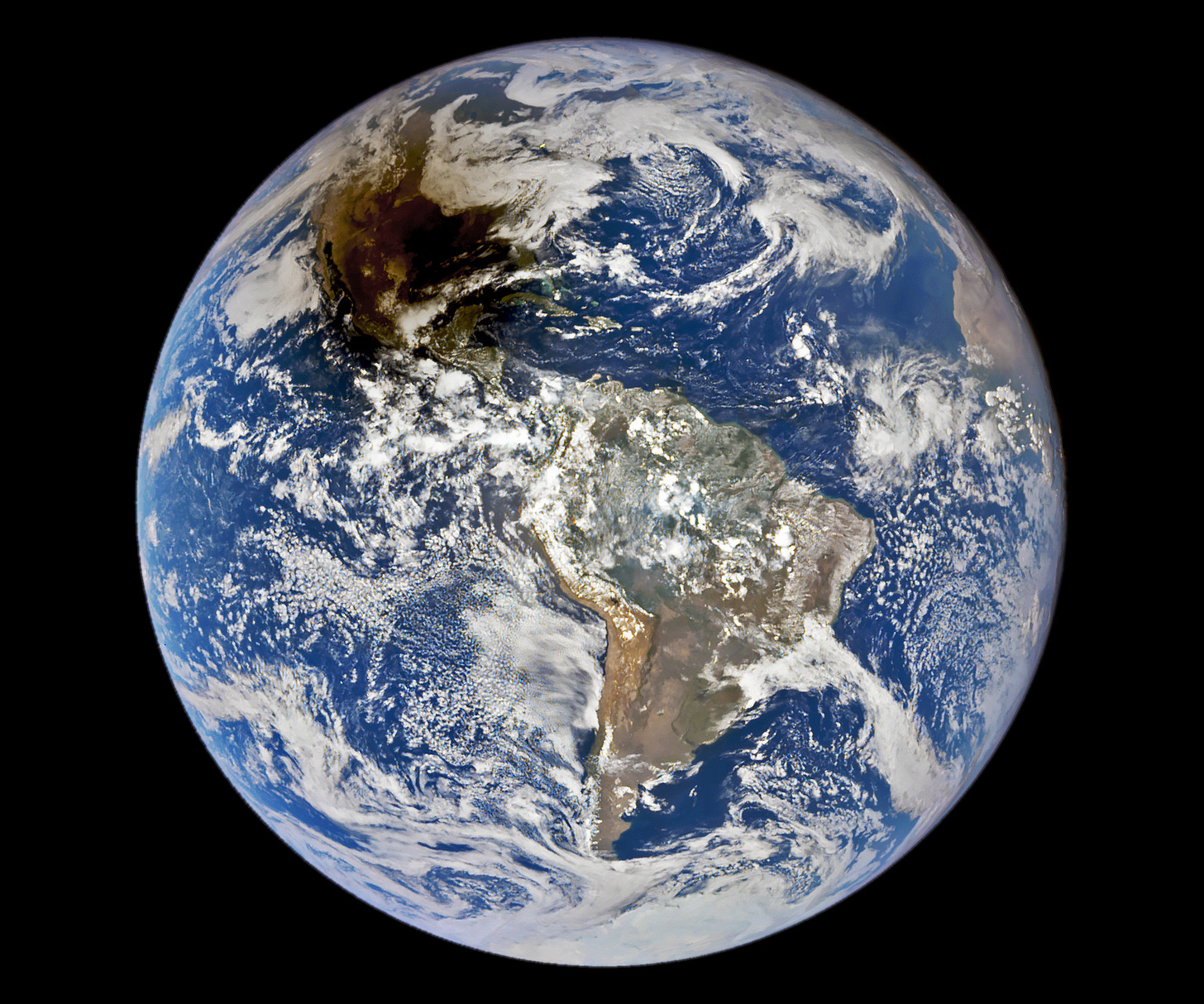
Satellite sees annular solar eclipse from 1 million miles away [link]
"Last weekend's "ring of fire" solar eclipse was spectacular from deep space as well.
The stunning shot comes courtesy of the DSCOVR satellite.
DSCOVR lies nearly 1 million miles (1.6 million kilometers) from Earth, so its perspective is a unique one. The image shows our brilliant blue planet against the blackness of space, its vibrant hues muted in one sizable patch — much of North America — by the moon's dusky shadow."
Related: Darkened by the Moon’s Shadow [link]
Highlights from Planet's Investor Day
Planet hosted an Investor Day in San Francisco on Tuesday, October 10, 2023.
Highlights included:
Announcing that the Pelican-1 spacecraft is at launch site at Vandenberg Air Force Base!
Showcasing the Sentinel Hub platform and self serve on it
Showing how AI grows the servicable market and speeds customer time to value
Reiterating our focus on durable growth & efficient execution
Full recording here
Canada to invest C$1.1 bln in satellite tech for better earth data [link]
"Canada on Wednesday said it will invest C$1.01 billion ($740.90 million) over the next 15 years in satellite technology to boost the earth observation data that it uses to track wildfires and other environmental crises.
The new initiative called Radarsat+ will gather information about Earth's oceans, land, climate, and populated areas, a statement by the Canadian Space Agency (CSA) said."
Related: Observing Earth from space: Canada defines the future of satellite data [link]
HLS Team Completes Historical Processing [link]
"The completion of historical processing of the Harmonized Landsat and Sentinel-2 (HLS) S30 data product provides a continuous archive of Sentinel-acquired HLS data and imagery dating back to 2015. Combining the S30 data with previously back-processed HLS Landsat-acquired (L30) data (which was accomplished in May 2022) creates a continuous HLS data and imagery archive from 2013 to present."
New CropSAR service provides cloud-free time series at pixel level [link]
"In 2019 VITO Remote Sensing released CropSAR, a service that combines both optical data from Sentinel-2 and radar data from Sentinel-1 to be able to look through the clouds and improve crop monitoring. CropSAR is still a valuable service to provide insights into crop performance, empowering farmers to make informed decisions for maximizing yields and sustainability.
Recently, they developed an additional CropSAR service (CropSAR 2D) which allows to produce cloud-free image time series at 10 m resolution every 5 days. This new service can take multiple monitoring application to the next level whereas the original CropSAR at field level (CropSAR 1D) focused specifically on agricultural applications."
Urban Sky Nabs $9.75M for Stratospheric Balloon Imaging [link]
"Urban Sky, a stratospheric balloon imaging startup, announced a $9.75M Series A round yesterday to build out its sensor tech and expand commercial imaging capabilities to 15+ states.
Balloon pics: The company relies on small reusable balloons to capture high-resolution pictures for customers. Its mobile launch system and controlled descent allow the company to maneuver its balloons over a specific area to capture a precise picture—solving a problem typically faced by stratospheric balloons.
The company sensor payloads can capture ~10cm high-resolution images and ~3.5m long-wave-infrared data.
Its imaging sensors use component miniaturization and weigh just 6 lbs."
BlackSky Wins Air Force Research Contract [link]
"BlackSky Technology won a competitive U.S. Air Force Research Laboratory contract to build an automated target recognition service that can track vehicles in real time from space."
Euroconsult and Iceye to Lead a European EO Consortium [link]
"Euroconsult and Iceye are teaming up to lead a new consortium of European space companies conducting a study on a future European Union Earth observation governmental service. The new consortium announced Oct. 11 is named AEGIS, which stands for Advanced European Governmental Innovative ISR Secured Service."
Developer’s Orbit
Introducing Earth Search Console: An AWS Open Data Exploration UI [link]
"Element 84 introduced Earth Search Console, a new mapping interface that complements the existing Earth Search API. While APIs are powerful tools for data retrieval, pulling usable data visualizations from APIs can be challenging and time consuming for users without a broad technical understanding. Earth Search Console addresses this challenge by providing a simplified, user-friendly interface, making data exploration and access more accessible to a broader audience.
Earth Search Console is a platform where users can, at no cost, view geospatial data and enables users to access collections of publicly available geospatial data available on AWS."
Introducing the ultimate cloud-native building footprints dataset [link]
VIDA introduced the most comprehensive, freely available, global, cloud-native building footprint dataset available today, with over 2.5 billion buildings, by merging the Google and Microsoft datasets.
It’s hosted on the Source Cooperative and accessible on map.vida.place/explore.
Snapshots
Lightning Events Detected from the International Space Station (ISS) 2017-2023 [link]
"The Lightning Imaging Sensor (LIS) on the International Space Station (ISS) detects lightning occurring in the Earth’s tropical and mid-latitude regions. The LIS provides datasets consisting of near-real time and non-quality controlled data as well as final quality controlled datasets that are manually reviewed. This data uncovers the variability and distribution of lightning and can be used for storm detection and lightning-atmosphere interaction studies."
Antarctic ice shelf demise [link]
"New research, utilizing data from ESA’s Copernicus Sentinel-1 and CryoSat satellite missions, offers a stark view of the state of Antarctica’s ice shelves.
Over the last 25 years, 40% of these vital floating extensions of the continent’s ice sheet have significantly diminished in volume, releasing approximately 67 trillion tonnes of meltwater into the ocean. This loss is driven by a complex interplay of ocean temperatures and currents around Antarctica, with the western side exposed to warmer waters eroding the ice shelves from below. The eastern side, protected by colder coastal waters, has fared better."
Interesting reads
TEMPO - Nitrogen Dioxide Air Pollution Over North America - Additional Views [link]
"The Tropospheric Emissions: Monitoring of Pollution (TEMPO) instrument measures sunlight reflected and scattered off the Earth’s surface, clouds and the atmosphere. Gases in the atmosphere absorb the sunlight, and the resulting spectra are then used to determine the amounts of several gases in the Earth’s atmosphere, including nitrogen dioxide.
In this visualization, high levels of nitrogen dioxide can be seen over multiple urban areas across the U.S., Canada, Mexico and the Caribbean. As the day progresses, the morning pollution often dissipates. Later in the afternoon, it will rise again as the cities enter their second rush hour of the day. Because TEMPO uses visible sunlight to make measurements, it cannot see pollution below clouds or at night. Cloudy areas appear as missing data in the visualization. This visualization shows data from August 28-31, 2023."
International Ocean Satellite Monitors How El Niño Is Shaping Up [link]
"Sentinel-6 Michael Freilich is the latest satellite contributing to a 30-year sea level record that researchers are using to compare this year’s El Niño with those of the past.
The maps above show sea levels in the Pacific Ocean during early October of 1997, 2015, and 2023, in the run up to El Niño events. Higher-than-average ocean heights appear red and white, and lower-than-average heights are in blue and purple. Credit: NASA/JPL-Caltech"
One of the largest ozone holes in years [link]
"EOC assessments show that this year’s ozone hole is one of the largest since measurements began. The record size can probably be attributed to the 2022 eruption of Hunga Tonga volcano.
The eruption of the Hunga Tonga volcano in January 2022 injected a lot of water vapour into the stratosphere which only reached the south polar regions after the end of the 2022 ozone hole.
The water vapour could have led to the heightened formation of polar stratospheric clouds, where chlorofluorocarbons (CFCs) can react and accelerate ozone depletion. The presence of water vapour may also contribute to the cooling of the Antarctic stratosphere, further enhancing the formation of these polar stratospheric clouds and resulting in a more robust polar vortex."
DLR flight campaign over Cyprus [link]
"From October 9 - 14, DLR conducted a measurement campaign in Cyprus. On board the DLR research aircraft of type Dornier Do 228-212, the optical 3K camera system developed by DLR, as well as the imaging spectrometer HySpex were used. The measurements are intended to provide information on how climate change is altering agriculture in arid regions such as Cyprus, and how urban temperatures are developing there. In addition, the recordings will be used to find clues to undiscovered archaeological sites. The research was conducted in collaboration with the Eratosthenes Center of Excellence (CoE)."
Competitions
Contest 2023 for best satellite image of Earth [link]
"Take part in the 4th edition of the contest 'Seize the beauty of our Planet'.
This edition focuses on GLOBAL WARMING. That is why, the contest motto is: Together for Cool Earth! The goal of this year's contest is to support the joint effort of many European and international organisations in tackling global warming on Earth."
Upcoming Events
NoR Webinar series enters a new training season [link]
"NoR Webinar series is back with a set of introductory sessions starting on the 20th of October 2023. From data discovery and access to advanced data processing services, algorithm hosting and sharing, the sessions will walk you through interactive platform demonstrations and relevant use-cases illustrating the different platform capabilities and the workflows and applications that can be built using them."
GIS for Climate Action [link]
This free MOOC is offered by ESRI; Students will explore how GIS is being used today to understand and prepare for a future that requires more resilient communities, systems, and infrastructure.
Learning
WEkEO workshop - Monitoring Cryosphere Changes; Recordings and presentations
Presentations HERE
Tutorials : Jupyter Notebook and QGIS


