

Level-2 News
NASA Selects Commercial Smallsat Data Acquisition Contractors [link]
"NASA has selected seven companies to provide commercial data in support of the agency’s Earth science research. The maximum potential value is cumulatively $476 million among all contractors selected.
The following companies were selected as part of this full and open competition:
Airbus DS Geo, Inc. of Herndon, Virginia
Capella Space Corp. of San Francisco
GHGSat, Inc. of Montreal
Maxar Intelligence, Inc. of Westminster, Colorado
Space Sciences and Engineering (dba PlanetiQ) of Golden, Colorado
Spire Global Subsidiary, Inc. of Vienna, Virginia
Umbra Lab, Inc., of Santa Barbara, California"
NV5 Awarded $10 Million Geospatial Forest Resource Management Contract [link]
"NV5 Global announced that it has been selected by United States Geological Survey (USGS) for a $10 million contract to perform geospatial lidar data collection and processing of 28,359 square miles in Oregon and Washington state as part of the USGS 3D Elevation Program (3DEP)."
Open Cosmos’s MANTIS Satellite to Launch via SpaceX Transporter 9 [link]
"Open Cosmos and the European Space Agency (ESA) have announced plans to launch the MANTIS satellite aboard the upcoming SpaceX Transporter-9 mission.
MANTIS, which stands for Mission Agile Nanosatellite for Terrestrial Imagery Services, will be the first satellite launched as part of ESA InCubed, the co-funding program run by ESA Φ-lab which focuses on commercial development activities across the entire Earth observation (EO) value chain, including satellites, ground applications, downstream applications, and new EO business models.
The satellite will host an innovative multispectral, high-resolution optical payload for EO and a secondary payload, a high-performance and reconfigurable processing unit aimed at exploiting the power of Artificial Intelligence to derive insights onboard."
Capella Space Announces Move to Larger Colorado Facility to Accommodate Accelerating Business [link]
"Capella Space announced it has doubled the size of its office space and manufacturing floor by moving into a new, 32,000 square foot facility in Louisville, across town from Capella’s previous office. This new space will be able to accommodate more than 150 employees."
NRO Formally Ends Contract with Terran Orbital for SAR [link]
"Last month, the National Reconnaissance Office (NRO) formally ended a commercial radar contract the agency had with PredaSAR, now Terran Orbital, the NRO said on Oct. 2."
NASA Extends Commercial Data Agreement With Planet With $18.5M in Orders [link]
"NASA extended its blanket purchase agreement (BPA) with Planet, placing multiple orders totaling $18.5 million through 2024, Planet announced Friday.
The BPA is part of NASA’s Commercial Smallsat Data Acquisition (CSDA) program. Planet has worked with the space agency through CSDA since it was a pilot program in 2018."
Developer’s Orbit
Build a crop segmentation machine learning model with Planet data and Amazon SageMaker geospatial capabilities [link]
"Amazon SageMaker geospatial capabilities combined with Planet’s satellite data can be used for crop segmentation, and there are numerous applications and potential benefits of this analysis to the fields of agriculture and sustainability.
Crop segmentation is the process of splitting up a satellite image into regions of pixels, or segments, that have similar crop characteristics. This post illustrates how to use a segmentation machine learning (ML) model to identify crop and non-crop regions in an image."
Snapshots
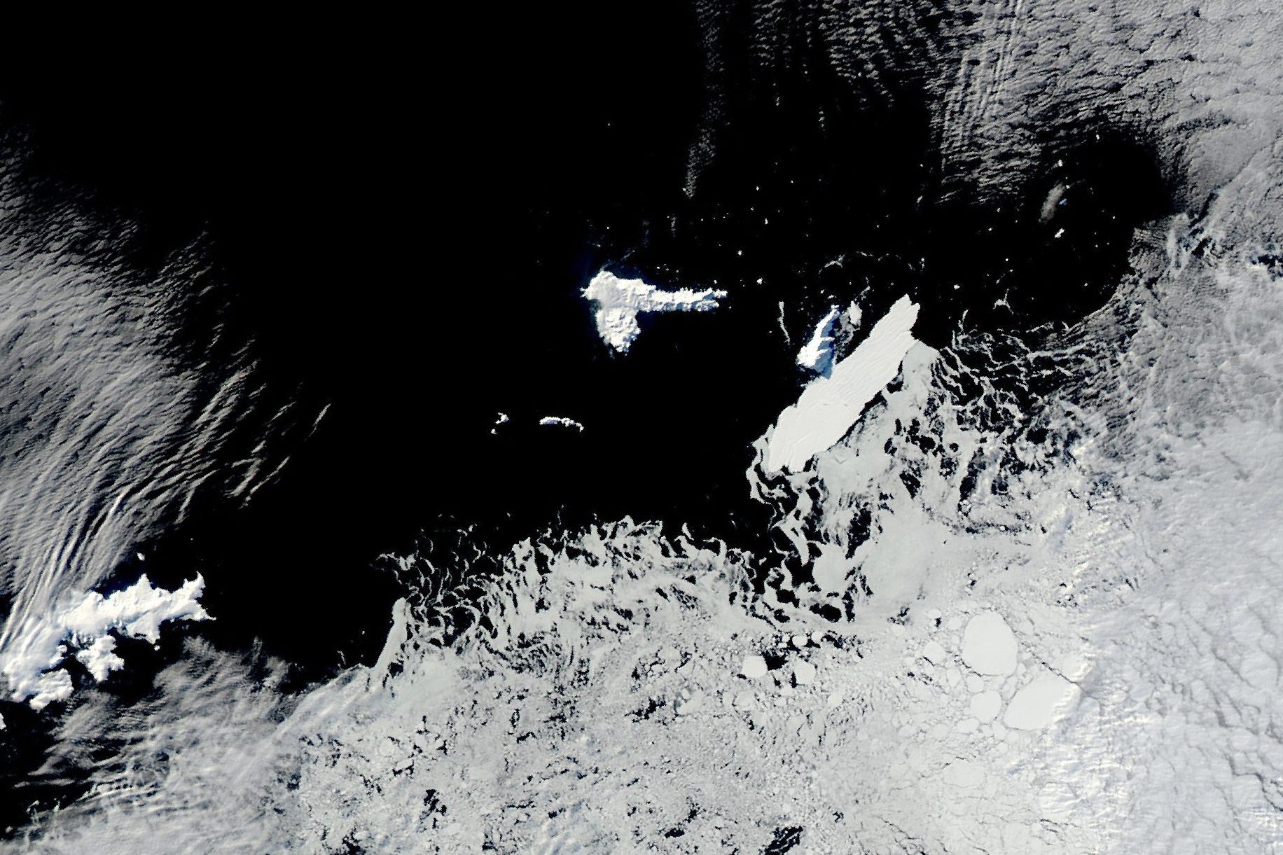
A Brief Iceberg–Island Encounter [link]
"In June 2021, the U.S. National Ice Center reported that a collision between iceberg D-28 and the Borchgrevink Ice Shelf in the Queen Maud Land region of East Antarctica had formed a new tabular berg called D-30.
The MODIS (Moderate Resolution Imaging Spectroradiometer) sensor on NASA’s Aqua satellite captured this image of D-30A at the edge of Clarence Island on September 6, 2023."
Interesting reads
Using Satellite Imagery To Determine Field-Level Planting Dates Across The US Corn Belt [link]
"NASA Harvest’s Jill Deines recently explored how planting dates across the Midwestern United States have changed over the past two decades. Along with her co-authors, Deines generated field-scale (30 meter) planting date maps from 2000-2020 for maize and soybean fields in 12 major producing US states. These maps form a data archive of planting dates that will provide critical information for future farmer management decisions and improve understanding of surrounding ecology."
Putting Earth Observations Into Action For Disaster Management [link]
"Members of the NASA Harvest consortium recently co-authored a working paper for the United Nations Office of Disaster Risk Reduction on how Earth observations (EO) can be used to support risk-informed decision making. The paper covers a variety of disaster responses from flooding and wildfires to seismic activity. Harvest Consortium members focused on how EO data is being used to monitor shocks to global agriculture and help mitigate global food insecurity."

The ESA Φ-lab Newsletter #10 | September 2023 [link]
Learning
Presentations and recordings from the 5th ESA/EUMETSAT/ECMWF Joint School on Atmospheric Composition [link]