

Level-2 News
Planet Closes Sinergise Acquisition [link]
“Planet has closed its acquisition of Slovenian company Sinergise to expand and enhance its Earth Data Platform. Planet announced the acquisition in March of this year.
This is Planet’s sixth acquisition. It acquired the BlackBridge group of companies in 2015, Terra Bella business from Google in 2017, Boundless Spatial in 2019, VanderSat in 2021, and Salo Sciences in 2023.”
NASA Announces Launch Service for Arctic Warming Experiment [link]
“The PREFIRE mission will send two CubeSats into space to study how much heat the planet absorbs and emits from its polar regions, including the Arctic and Antarctica.
Data from the mission will inform climate and ice models, providing better projections of how a warming world will affect sea ice loss, ice sheet melt, and sea level rise.”
July 2023 Record High Global Temperatures [link]
“July 2023 set a record for the warmest month on record (since 1880). July 2023 was 0.24 degrees Celsius (0.43 degrees Fahrenheit) warmer than the previous record. The globally averaged temperature in July 2023 was 1.18 degrees Celsius (2.12 degrees Fahrenheit) warmer than the average July temperature (as compared to the baseline period 1951–1980). July is also, on average, the warmest month of the year.
The combination of these factors led to July 2023 setting the mark as the warmest month since 1880.”
NRO to select providers of new forms of optical satellite imagery [link]
“The National Reconnaissance Office (NRO) is seeking commercial sources of nighttime imaging, non-Earth imaging, multispectral and infrared imaging.”
China launches first geosynchronous orbit radar satellite [link]
“China launched what is thought to be the world’s first geosynchronous orbit synthetic aperture radar satellite on Saturday.
The L-band synthetic aperture radar (SAR) satellite will provide all-day, all-weather observation of China and surrounding areas, boosting the country’s disaster prevention, reduction, and relief capabilities.”
NOAA Awards MyRadar a Grant for 2 Pathfinder Satellites [link]
“The National Oceanic and Atmospheric Administration (NOAA) awarded weather app MyRadar a grant for a satellite mission to improve resilience against wildfires.”
NASA Awards $6.5 Million Contract to Spire Global for Earth Observation Data [link]
“Spire Global announced it was awarded a $6.5 million, 12-month contract renewal to continue participation in NASA’s Commercial Smallsat Data Acquisition (CSDA) Program.”
Europe space chief warns over political wavering on climate [link]
“Josef Aschbacher, director general of the European Space Agency, has urged wavering politicians not to abandon European leadership in combating climate change, saying record heatwaves and vegetation fires provide “really alarming” evidence of the pace of global warming.”
Greece gets a sharper eye in the sky in local deal [link]
“The Hellenic Space Center (HSC) signed a deal on Thursday with local firm TotalView that will give state agencies access to high-quality satellite images — superior to the EU’s Copernicus program — that they can use to track wildfires and gauge their aftermath, capture environmental violations, help map property lines, assess farmers’ compensation claims and much more.”
Developer’s Orbit
Xarray: Empowering Scientific Data Analysis within the NASA community [link]
“Xarray’s flexibility has played a pivotal role in NASA’s transition to cloud computing infrastructure, ensuring efficient and robust data processing for the agency’s vast repositories of information. Xarray is a common component in workflows involving NASA datasets across many domains, including physical oceanography, and glaciology.”
Open source PySAMOSA SAR Satellite altimetry retracking software released [link]
“PySAMOSA is a Python-based software for processing open ocean and coastal SAR altimetry waveforms (Level-1b data) from SAR satellite altimetry to measure sea surface heights, wave heights, and wind speed for the oceans and inland waters.”
PySAMOSA on GitHub [link]
Data
NASA Acres and Harvest Program Scientists have compiled a number of satellite-based resources to help monitor impacts of Maui Wildfires [link]
“The Maui County Food Security Data Visualization Project is a partnership between Maui United Way, Responsible Markets (Maui ESG Project), University of Hawaii, and NASA Acres/NASA Harvest, funded by NASA. It aims to address critical data gaps in Maui County related to food insecurity and climate change with satellite imagery and machine learning.”
Snapshots
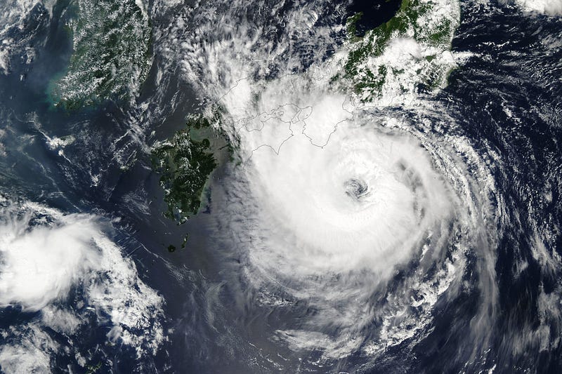
Typhoon Lan Lashes Japan [link]
“Less than one week after Typhoon Khanun charted a zigzagging course toward southern Japan, the country was preparing for yet another major storm — Typhoon Lan.”

Planet Snapshots Issue 87: Methane [link]
In this week’s issue:
Collaboration issue with EcoFlight to explore the methane problem from above
Algal explosions amid hot weather
Interesting reads
Introducing VEDA: An Open Science Platform to Accelerate Earth Science Research and Application [link]
“NASA-IMPACT recently introduced VEDA — an open platform designed to transform how we visualize, explore, and analyze Earth data in the cloud.”
Earth observation evolution: Bigger satellites promise bigger payoff for imagery operators [link]
Follow this article on how satellites grew larger and heavier and the drivers of this evolution.
Documentary

FIRE | An ESA documentary [link]
“The summer fire season is well under way in Europe — countries all around the Mediterranean are experiencing record temperatures coupled with huge wildfires that have led to mass evacuations. In this enthralling new ESA documentary, explore how people on the frontline are using space to better monitor and fight the flames.”
Upcoming Events
1st EnMAP User Workshop [link]
“Deep-dive into sensor insights, data workflows, and user experiences. Brought to you by DLR & GFZ.”
Start: Tuesday, 10 October | 10.00 am CEST / Berlin time
End: Wednesday, 11 October | 06.00 pm CEST / Berlin time
Call fo papers
The Artificial Intelligence for Humanitarian and Disaster Response (AI+HADR) [link]
Researchers are invited to submit their recent work on the topic in the intersection of Artificial Intelligence (AI) and Humanitarian Assistance and Disaster Recovery (HADR) problems to be featured at our workshop at NeurIPS 2023 in New Orleans, Louisiana, USA.
Submissions Due: September 29, 2023
Workshop: December 15th, 2023
Learning
Automated Segmentation of Remote Sensing Imagery with the Segment Anything Model [link]
Recording, slides and code of the presentation at the TensorFlow Working Group at SERVIR by Qiusheng Wu.