

Weekly newsletter on Earth Observation
Level-2 News
NASA and IBM Openly Release Geospatial AI Foundation Model for NASA Earth Observation Data [link]
“A public/private partnership involving NASA and IBM Research has led to the release of NASA’s first open-source geospatial artificial intelligence (AI) foundation model for Earth observation data. Built using NASA’s Harmonized Landsat Sentinel-2 (HLS) dataset, the release of the HLS Geospatial Foundation Model (HLS Geospatial FM) is a milestone in the application of AI for Earth science.”
Hugging Face [link]
ICEYE US Receives First Task Order Under NASA Commercial SmallSat Data Acquisition Program [link]
“ICEYE US Inc received its first Task Order under a Blanket Purchase Agreement (BPA) with NASA announced earlier this year. The Task Order enables NASA to acquire ICEYE’s synthetic-aperture radar (SAR) data for evaluation by scientific and academic communities to determine suitability for advancing NASA’s Earth Science research objectives. The BPA is funded by the Earth Science Division of the Science Mission Directorate.”
NOAA lifts many commercial remote sensing license conditions [link]
“The agency that regulates commercial remote sensing satellite systems has loosened restrictions imposed on many companies’ licenses, enabling them to provide higher-resolution imagery or other services.”
TROPICS cubesat constellation ready for hurricane season [link]
“A quartet of cubesats launched in May to monitor the development of tropical storm systems is working just in time to support monitoring of the Atlantic hurricane season.
Four cubesats for NASA’s Time-Resolved Observations of Precipitation structure and storm Intensity with a Constellation of Smallsats (TROPICS) mission launched on a pair of Rocket Lab Electron rockets May 7 and May 25. The satellites have been undergoing tests of their main instruments, microwave radiometers to collect temperature and humidity data on tropical storms.”
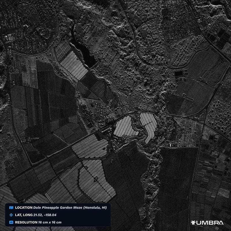
Umbra Releases a 16 cm Commercial Satellite Image [link]
“Satellite operator Umbra released a 16 cm/pixel Synthetic Aperture Radar (SAR) image today, making it the highest-res commercial satellite image ever dropped, according to the company.”
Capella’s Earth-imaging satellites are deorbiting faster than expected [link]
“Capella Space’s synthetic aperture radar satellites are falling back to Earth much sooner than the three years they were anticipated to operate, according to publicly available satellite data.
Capella-7 and Capella-8, launched in January 2022, appear to be now operating below 400 kilometers, and will likely deorbit in a matter of weeks to a few months.”
BlackSky Posts Double-Digit Revenue Increase in Q2 [link]
“BlackSky Technology reported $19.3 million in revenue in the second quarter of 2023, up 28% from the prior year period, citing increased demand for satellite imagery and monitoring. The company reported financial results on Wednesday, along with a deal for five Rocket Lab launches.”
GHGSat orders four more greenhouse gas monitoring cubesats from Spire [link]
“GHGSat has ordered another four 16U cubesats from Spire Global for a launch no earlier than 2024 to expand its greenhouse gas-monitoring constellation, the Canadian satellite operator announced Aug. 8.”
China Launches New Meteorological Satellite [link]
“China on Thursday the 3rd of August, successfully launched a meteorological satellite, the Fengyun-3 06, which is expected to provide accurate forecasts for extreme weather conditions including rain storms and typhoons.”
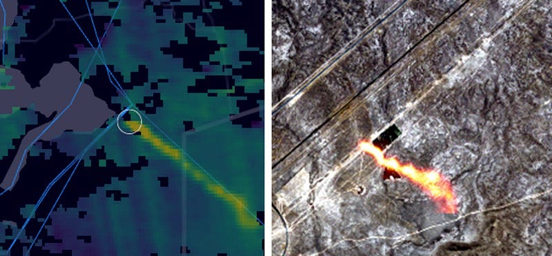
Satellites Detect Methane Leak in Kazakhstan Raising Climate Concerns [link]
“Scientists have detected a huge methane leak in a remote region of Kazakhstan. The leak is coming from a natural gas well blowout that occurred on June 9th, 2023. Satellite images show giant clouds of methane spewing from the site.”
Developer’s Orbit
ESA WorldCereal — Getting Locations for Global Field-Level Monitoring in Python [link]
“With the release of the ESA WorldCereal system, we now have (for the first time ever) the precise location of essentially every winter cereal, spring cereal and maize farm in the world.
To put the precision in perspective, the best datasets available to date were at 10km and ~5km resolutions via SPAM2010 and GEOGLAM, respectively. WorldCereal is 10m resolution — that’s 1000 times more precise. In fact, this is even better than the 30m resolution that the USDA has on offer with the USDA CDL (Cropland Data Layer).
This tutorial shows you how to convert WorldCereals into points samples in Parquet or GeoParquet. It will show how to:
Generate any number of global maize, winter cereals, and spring cereals farm point locations (longitude, latitude coordinate pairs) from the .tif classification mask files
Export the locations to cloud-native (Parquet & GeoParquet) and standard tabular (CSV) formats”
Kerchunk Cookbook [link]
“This Project Pythia Cookbook covers using the Kerchunk library to access archival data formats as if they were ARCO (Analysis-Ready-Cloud-Optimized) data.
The Kerchunk library allows you to access chunked and compressed data formats (such as NetCDF3. HDF5, GRIB2, TIFF & FITS), many of which are the primary data formats for many data archives, as if they were in ARCO formats such as Zarr which allows for parallel, chunk-specific access.”
Data

VHRShips: An extensive benchmark dataset for scalable deep learning-based ship detection applications
“VHRShips comprises of 6312 optical satellite images collected from Google Earth. While 1000 images don’t include any ship, rest of them consist 11337 ships in 34 different classes. VHRShips has high definition, inshore and offshore images from various locations, rich metafile content and includes noisy images representing real scenarios.”
Snapshots
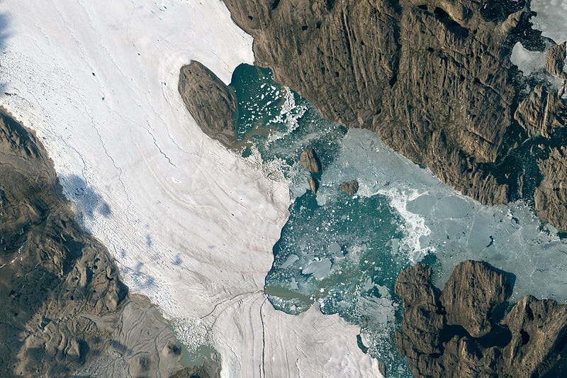
Summer Breakout in Northeast Greenland [link]
“Summer can be cruel to the planet’s remaining ice. Over the span of just days in July 2023, seasonal warmth led to the rapid disintegration of sea ice near the junction of two large outlet glaciers in northeast Greenland.”
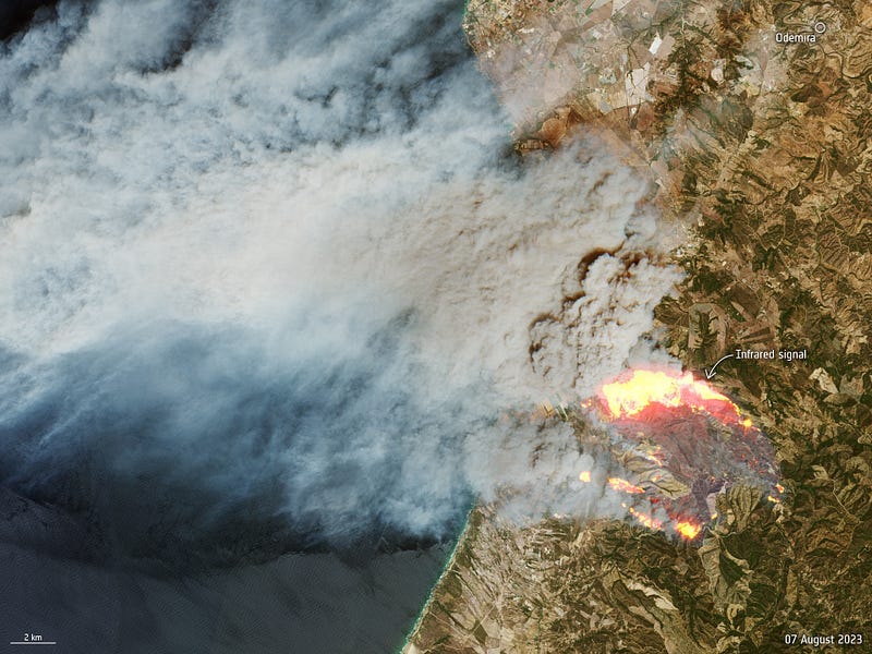
Portugal blaze [link]
“With Portugal in the grip of a heatwave, a wildfire broke out on 5 August south of Odemira in the Alentejo region in southern Portugal. This image, captured by the Copernicus Sentinel-2 satellite mission, shows the fire on 7 August.
The smoke billowing from the fire and being blown towards the Atlantic is clear to see in this true colour Sentinel-2 image. The image has been overlaid with information from the satellite instrument’s shortwave infrared channels to highlight the emitting heat sources which, in this case, can be linked to the fire front.”
NASA Data Shows Fierce Surface Temperatures During Phoenix Heat Wave [link]
“Researchers at NASA’s Jet Propulsion Laboratory have created a series of maps showing land-surface temperatures in the Phoenix area in July 2023, when the city experienced a record-breaking run of hot weather. The images reveal the cumulative effect — overnight and across the month — of relentless daytime heating.”
GPM Captures Powerful Typhoon Khanun Approaching the Ryukyus [link]
“Khanun (known as “Falcon” in the Philippines) began in the West Pacific Ocean as an area of disturbed weather on July 24 situated well south of Guam and east of Palau. Over the next several days the system slowly intensified as it tracked northwestward towards the Ryuku Islands of southern Japan, becoming a tropical depression on July 27 as it entered the eastern Philippine Sea, a named tropical storm on July 28, and finally a typhoon on July 30 (local time) while moving through the north-central Philippine Sea.”
Related:
A Zigzagging Path for Khanun [link]
Interesting reads
The challenge of Analysis Ready Data in Earth Observation — Towards seamless integration: The quest for interoperable and harmonized EO data [link]
Follow my article on Analysis Ready Data where I discuss what I consider two different version of ARD; a “traditional” and an “expanded” version.
I discuss interoperability and harmonization among datasets as well as a future of ARD as envisioned by a recent study from the Landsat Advisory Group.
Upcoming Events
Webinar: Earth Observation for Hydrology in Africa [link]
“The Webinar will include two sessions.
The first will showcase general information on what is already done on hydrology in Africa and its importance.
The second session will provide practical information on how to access the data and on ways to train on it.
The webinar will start at 08:00 UTC for the first part and at 12:00 UTC for the second part, with a 2 hours break between the sessions.”
August 24, 2023
EUMETSAT series of short courses: CLARA — A new Climate Data Record on Earth Radiation Budget [link]
“This online short course presents CLARA-A3, the latest edition a global climate data record on clouds, surface albedo and surface radiation, generated by the Satellite Application Facility on Climate Monitoring (CM SAF).
During the approximately two-hour course, participants get the chance to learn from CM SAF experts about all important features and highlights of the data record. In a hands-on session, users start working with the data to get insights into data handling and data formats.”
20 September 2023, 12:00–14:00 UTC
