

Level-2 News
UK Space Agency: £15m funding for technologies to monitor the Earth from space [link]
“The UK Space Agency has announced new funding for satellite Earth Observation technologies which are critical to improving humanity’s understanding of our planet and its climate.
The agency has got £15m that can be used to support the research and experimental development of space-based instruments, aimed at supporting a range of environmental services, which could include meteorology, climate monitoring, environmental management, agriculture and urban planning, and improving scientific knowledge.”
ISRO Successfully Launches Seven Singaporean Satellites as Part of Commercial Mission [link]
“The Indian Space Research Organisation (ISRO) announced the successful launch of PSLV-C56 carrying the DS-SAR satellite, along with 6 other satellites from the first launch pad of SDSC-SHAR, Sriharikota on July 30, 2023.”
BeZero Carbon and Kayrros join forces [link]
“Global carbon ratings agency BeZero Carbon is partnering with Kayrros to map the Amazon basin using satellite imagery and geospatial data to rate carbon projects. Kayrros’ satellite-based data on forest structure and carbon will inform BeZero Carbon’s risk assessments of credits from the region.
Azerbaijan’s Azercosmos reports of its export earnings [link]
“In January-June this year, Azercosmos, under the Ministry of Digital Development and Transport of Azerbaijan, exported services worth $9.5 million (AZN 16.1 million) to 43 countries.
Azercosmos exported services are satellite based on telecommunications and optical satellite data”
Data

NLCD 2021 Now Available [link]
“The U.S. Geological Survey (USGS), in association with the Multi-Resolution Land Characteristics (MRLC) Consortium, is pleased to announce the completion and release of the latest epoch of the National Land Cover Database (NLCD) for the conterminous U.S. — NLCD 2021.”
NLCD 2021 is primarily based on 30-meter resolution Landsat satellite data. The NLCD has been one of the most widely used geospatial datasets with 12,000 plus research citations serving as a basis for understanding the nation’s landscapes in thousands of studies and applications. It is trusted by scientists, land managers, college students, city planners, and many others.”

The United States Department of Agriculture (USDA) Crop Sequence Boundaries (CSB) product [link]
“The Crop Sequence Boundaries developed with USDA’s Economic Research Service, produces estimates of field boundaries, crop acreage, and crop rotations across the contiguous United States. It uses satellite imagery with other public data and is open source allowing users to conduct area and statistical analysis of planted U.S. commodities and provides insight on farmer cropping decisions.”
Overture Maps Foundation Releases Its First World-Wide Open Map Dataset [link]
“The Overture Maps Foundation (OMF), a collaborative effort to enable current and next-generation interoperable open map products, announced the release of its first open map dataset.
It is available in cloud-native Parquet and stored on AWS and Azure.”
Snapshots
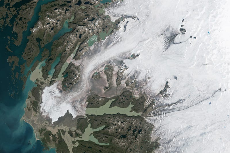
Wasting Away (Again) in Greenland [link]
“More than halfway through the 2023 melting season, Greenland has seen a substantial transformation of its snow cover. Melting has been above average for much of the season, including on several days in June and July when melt was detected across 800,000 square kilometers (302,000 square miles) — up to 50 percent — of Greenland Ice Sheet’s surface, according to the National Snow and Ice Data Center.”
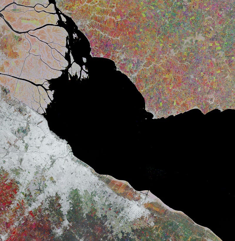
Earth from Space: Río de la Plata [link]
“The Copernicus Sentinel-1 mission takes us over the Río de la Plata estuary between Argentina and Uruguay.
This image was created by combining three different radar images from July and November 2022 and March 2023. Each image has been assigned a colour: red, green and blue respectively. This technique is used to highlight changes between acquisitions and to monitor the vegetation growth.”
Interesting reads
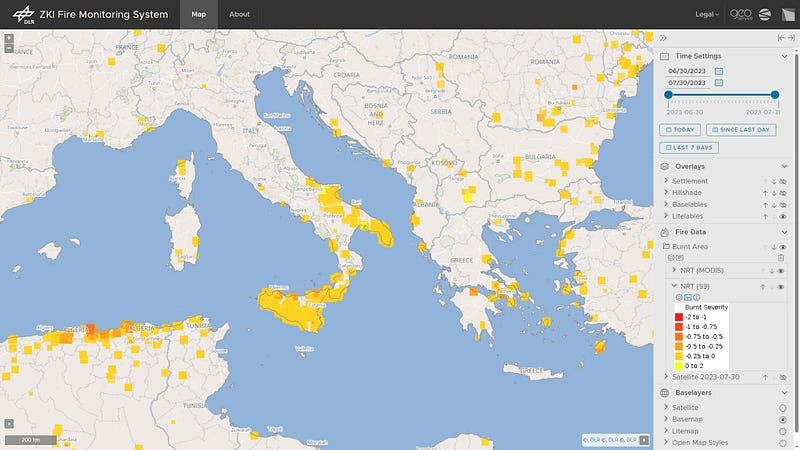
Daily monitoring of forest fires around the Mediterranean Sea [link]
“The wildfires in the Mediterranean region were exceptionally intense in July 2023, causing devastating damage. According to EFFIS, Europe’s Copernicus Program, the area burned is nearly twice as large as the long-term average. An EOC (Earth Observation Center) web service shows daily updates on the development of the fires. Evaluations made by the Center for Satellite-based Crisis Information (ZKI) provide information about the extent of damage, also using data from the German hyperspectral satellite EnMAP.”
Bridging Science and Society: NARSS’s Impact on Egypt’s Development and Technological Progress [link]
“The National Authority for Remote Sensing & Space Sciences (NARSS) is Egypt’s (and North Africa’s) oldest governmental institute dedicated to space technology and remote sensing. Its roots can be traced back to 1971 when it operated as a Center for Sensing and Space Technology. During this early phase, NARSS was crucial in receiving and processing data, including valuable information from Landsat, via its ground receiving station.
In his interview, Prof Islam Abou El-Magd, the President of NARSS, discusses how NARSS has significantly influenced Egypt’s (and Africa’s) involvement and advancements in space exploration and technology.”
The State of Earth Observation for Climate: 2023 Edition [link]
Read this deep dive by Aravind Ravichandran for an overview of the State of Commercial EO in Climate Tech.
Upcoming Events
ARSET — Satellite Data for Air Quality Environmental Justice and Equity Applications [link]
“In this training, the NASA Applied Remote Sensing Training (ARSET) program in collaboration with the Health and Air Quality Science Team (HAQAST) Tiger Team on Satellite Data for Environmental Justice, will demonstrate how remotely-sensed environmental indicators, specifically for air pollution, can be paired with demographic data to understand disproportionate exposures among minoritized and marginalized population subgroups.”
August 23, 2023 — September 6, 2023
Learning
Cloud-Based Remote Sensing with Google Earth Engine: Fundamentals and Applications (EEFA); Chapter “walk-through” Recordings [link]
Last week Tirthankar “TC” Chakraborty went through the EEFA book chapter on urban heat islands [link]
Follow the EEFA Book YouTube channel for other recordings [link]
