Level-2 News
Thermal data startup constellr raises 17 million euros [link]
“German thermal satellite data startup constellr raised 17 million euros ($18.93) in seed funding.
The first satellite in constellr’s operational constellation are scheduled to launch in 2024.”
ISRO eyes month-end launch for DS-SAR mission [link]
“The Indian Space Research Organisation (ISRO) is set to launch its next commercial mission, with the DS-SAR satellite from Singapore as its primary payload, on July 30.
The DS-SAR satellite carries a Synthetic Aperture Radar payload developed by Israel Aerospace Industries that allows the satellite to provide all-weather, day-and-night coverage. It is also capable of imaging at 1m-resolution at full polarimetry.”
Australia’s SmartSat, ESA’s Φ-lab Collaborate on Earth Observation [link]
“SmartSat has signed a new agreement with the European Space Agency’s (ESA) Φ-lab to collaborate on Earth Observation (EO) research.”
Crews Head Down River, Out to Sea to Prep New SWOT Water Satellite [link]
“In mid-June, a team of freshwater researchers spent their nights drifting down Alaska’s Yukon River in an area that straddles the Arctic Circle. The hydrologists were using a GPS unit installed on their boat to measure the slope of the river at the same time that the Surface Water and Ocean Topography (SWOT) satellite passed overhead, collecting its own data on the waterway. The midnight rendezvous were part of a larger effort by ocean and freshwater scientists to validate the measurements from the recently launched spacecraft, which begins science operations
SWOT is measuring the height of nearly all water on Earth’s surface and will provide one of the most detailed, comprehensive views yet of the planet’s ocean and fresh water.”
Developer’s Orbit
Cloud-Native Geo Data Explorations with Google Open Buildings [link]
Follow this blog post from Chris Holmes on how he transformed Google’s Open Buildings dataset into GeoParquet.
Snapshots
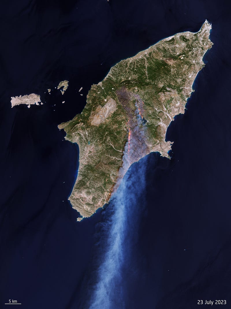
Rhodes wildfire forces thousands to flee [link]
“Wildfires burning on the Greek island of Rhodes have forced the evacuation of thousands of people as flames have spread from the island’s mountainous region to the coast.”
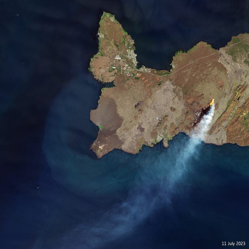
Litli-Hrútur eruption seen from space [link]
“On 10 July 2023, a volcano some 30 km from Iceland’s capital, Reykjavik, erupted following heightened seismic activity in the area. Satellites orbiting above us have captured the molten lava and smoke plume puffing from the Litli-Hrútur volcano.”
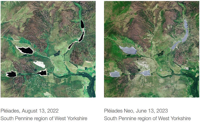
Climate Change: Drought in the UK; Water Management in the Brontë Country [link]
“Insufficient precipitation levels in the UK during the dry summer of 2022 has led to low ground moisture and depleted reservoirs. As a result, the country could experience water shortages in 2023. To tackle the issue, water management through satellite imagery allows us to monitor the evolution of water reserves and to assess the accumulated deficit from one year to the next. One example is in the country of the Brontë sisters, below the town of Haworth, where the writers lived and set their famous novels.”
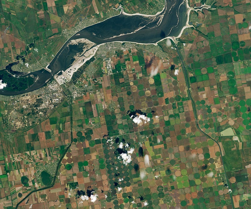
Canals in Ukraine are Drying Up [link]
“When the Kakhovka Dam was breached on June 6, 2023, water from the adjacent reservoir surged into the Dnipro River toward the city of Kherson and the Black Sea, causing severe flooding downstream. Floodwaters began to recede after a few weeks, but a slower-moving irrigation crisis has unfolded in southern Ukraine as networks of canals once fed by the Kakhovka Reservoir run dry.”
Planet Snapshots Issue 85: Biodiversity [link]
In this week’s issue:
Preserving biodiversity from space
“Floating” biome islands
Digital tour of animals
Interesting reads
The European heatwave of July 2023 in a longer-term context [link]
“Europe is experiencing some of the hottest temperatures of summer 2023 so far, as a ‘heat dome’ expands over the southern half of the continent. This weather pattern allows a warm air mass to build up under a high-pressure system, creating stable and dry conditions.”
Using Machine Learning to Integrate Mangrove Restoration with Sustainable Aquaculture Intensification [link]
“With support from the Innovation Grants Program, a diverse team of academics, conservation practitioners, and tech industry experts developed a rapid assessment tool, powered by AI and earth observation data, to identify and validate Climate Smart Shrimp sites in Indonesia and the Philippines.”
GPS satellites may be able to detect earthquakes before they happen [link]
“When it comes to knowing when an earthquake is coming, a crucial piece missing from the puzzle is what seismologists call a precursor: A telltale fingerprint of an earthquake that arrives before the big event. To date, no one has found a reliable precursor; many scientists don’t believe they’ll ever find one.
But two researchers may have made a breakthrough in the search for a precursor. If they are right, earthquakes may make their presence known through GPS measurements, several hours before their respective main events.”
Flash Drought Hotspots: Iberian Peninsula [link]
“It’s the third spell this summer to afflict the Iberian Peninsula, the stretch of land jutting out of southwestern Europe that contains the countries of Spain and Portugal (among others). A high-pressure system called an anticyclone reached the region from Africa and created a heat dome, thrusting the sizzling peninsula into peril with both atmospheric and land surface temperatures (LST) routinely exceeding 40°C (104°F) across the region.”
Competitions
Hackathons: Land cover mapping and machine learning + Global-FAPAR [link]
“The first two hackathons of the OEMC project challenge young researchers to map land cover class using machine learning and to model FAPAR at a high spatial resolution”
September 1st — 15th, on kaggle.com
Upcoming Events
Crop Monitoring and Yield Estimation from Space (Online Course) [link]
“The ever-increasing spatial resolution offered by the newest generation of satellite sensors allow us to monitor agricultural production at the scale of an individual parcel and to quantitatively estimate or predict productivity.
This course will provide/present participants with:
the most relevant data sources and data analysis techniques related to parcel-based crop monitoring and crop yield estimation.
knowledge on the primary plant function “photosynthesis” with the aim to better understand the role of evaporation, plus various qualitative and quantitative means to assess how lack of evaporation may impede a crop’s ability to convert CO2 and H20 into carbohydrates.
Practical assignments to use FPAR and ETA to quantitatively assess crop production.”
Deadline for applications: August 18, 2023


