Level-2 News

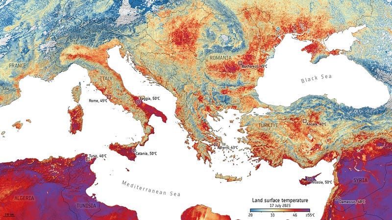
Europe braces for sweltering July [link]
“Temperatures are sizzling across Europe this week amid an intense and prolonged period of heat. And it’s only just begun. Italy, Spain, France, Germany and Poland are all facing a major heatwave with air temperatures expected to climb to 48°C on the islands of Sicily and Sardinia — potentially the hottest temperatures ever recorded in Europe.”
Related:
June 2023, record warmth in global surface air and sea surface temperatures [link]
U.S. Department of Agriculture Invests $300M to Monitor Greenhouse Emissions [link]
“U.S. Department of Agriculture (USDA) will invest $300 million to improve the measurement, monitoring, reporting, and verification of greenhouse gas emissions and carbon sequestration in climate-smart agriculture and forestry.”
Esri Releases Land Cover Map with Improved AI Modeling [link]
“Esri, in partnership with Impact Observatory, has released a global land-use/land-cover map of the world based on the most up-to-date 10-meter Sentinel-2 satellite data for every year since 2017. Following the latest 2022 data released earlier this year, the artificial intelligence (AI) model for classification has been improved, making the maps more temporally consistent.”
Data
Google released Open Buildings; A dataset of building footprints to support social good applications [link]
“Building footprints are useful for a range of important applications, from population estimation, urban planning and humanitarian response, to environmental and climate science. This large-scale open dataset contains the outlines of buildings derived from high-resolution satellite imagery in order to support these types of uses. The project is based in Ghana, with an initial focus on the continent of Africa and new updates on South Asia, South-East Asia, Latin America and the Caribbean.”
Related datasets:
EUBUCCO: European building stock characteristics in a common and open database for 200+ million individual buildings [link]
Building Footprints: An AI-assisted mapping deliverable with the capability to solve for many scenarios [link]

Carbon Mapper Builds Global Methane Emission Database [link]
“Carbon Mapper has made enhancements to the Carbon Mapper Data Portal which now features new data on global sources of methane plus improved functionality to make this data more accessible and actionable.”
Related:
Carbon Mapper released its first set of global emissions data from NASA’s EMIT sensor [link]
Satellite Image Time Series Datasets [link]
A list of satellite imagery datasets with a temporal dimension, mainly satellite image time series (SITS) and satellite videos, for various computer vision and deep learning tasks. It covers multi-temporal datasets with more than two acquisitions but not bi-temporal datasets.
Snapshots

Earth from Space: Ethiopian painting [link]
“Visible as the large round dark area, Lake Abbe, also known as Lake Abhe, straddles the border of Ethiopia to the west and Djibouti to the east. The lake is 19 km wide and 17 km long and is extremely salty. It is dotted with clusters of steaming limestone chimneys and surrounded by large salt flats, visible in white, and rift volcanoes. The biggest volcano in the image is Mount Dama Ali, a dormant 25-km-wide shield volcano that rises on the northwest shore of the lake.”

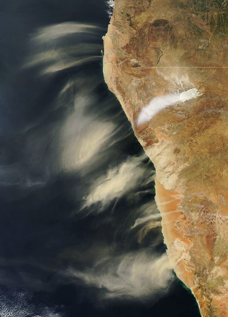
Dusts of Different Stripes [link]
“Easterly winds blew across Namibia in July 2023, lofting bands of dust across the coastal plains and out to sea. Streams of tan-colored dust jetted out from the entire length of Namibia’s coast and parts of the southern Angola coast.”

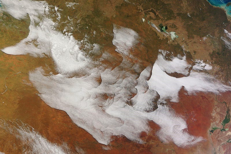
Curious Waves of Clouds Across Australia [link]
“An unusual collection of clouds appeared over the interior of Australia on the morning of July 5, 2023.
Several experts in cloud dynamics who looked at the image found the patterns to be both odd and fascinating, and they could not say with certainty what caused the complex formations based on the image alone. However, meteorological observations from that time offer clues into what may have been going on.”
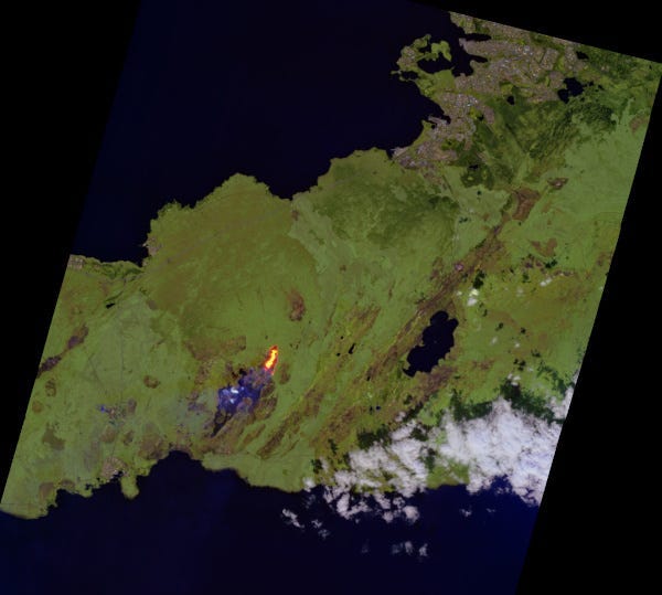
EnMAP records eruption of Fagradalsfjall on Iceland [link]
“On 10 July 2023 at 16:40 UTC there was an eruption of Fagradalsfjall volcano on Iceland’s Reykjanes peninsula southwest of Reykjavik.
Less than seven hours later the fissure vent eruption was recorded by the German hyperspectral satellite EnMAP (Environmental Mapping and Analysis Program). EnMAP has over 224 spectral bands available in the wavelength range between 420 and 2450 nanometers — in visible as well as near and shortwave infrared wavelengths — at a 30 meter ground resolution.”
Interesting reads
Hurricane Science at USGS
Follow this seven-part series highlighting USGS hurricane science.
Part 1: The 2023 Atlantic Hurricane Season is here [link]
Part 2: The USGS collects critical information about storm tides, one of the most serious hurricane threats to people and infrastructure [link]
Part 3: USGS science can inform communities of the coastal change hurricanes may bring [link]
Part 4: The USGS collects hurricane induced flood data along the coast and far inland [link]
Part 5: The USGS estimates potential spread of invasive species carried by hurricane-induced flooding [link]
Part 6: The USGS determines the extent of hurricane-induced flooding, which can help communities better prepare for future floods [link]
Part 7: The USGS provides maps and imagery for hurricane response [link]

Leveraging Satellite Technology for Advanced Detection and Monitoring of Oil Spills [link]
Read this story for how remote sensing helps with detecting and monitoring oil spils as well as predicting their trajectories and supporting clean-up operations.
Multiple new stories added to EO Dashboard related to Lakes! [link]
Troubled Waters: Unraveling the Impacts of Climate Change on Inland Waters [link]
Changes in temperature, precipitation patterns and extremes impacting surface water hydrology [link]
Algal blooms in lake waters [link]
Changing lakes due to human activity [link]
Competitions
“Earth at Risk” Image Contest [link]
“The IEEE GRSS Young Professionals and REACT Technical Committee (Remote sensing Environment, Analysis and Climate Technologies) announced the image contest “Earth at Risk”.
This contest aims to raise awareness of nature and climate crises and to demonstrate the power of Earth Observation (EO) data in helping us better understand the environmental changes on Earth and find solutions to protect our planet.”
Deadline: August 15, 2023
Upcoming Events
The Climate Change AI webinar series is back! [link]
July 28, 2023: Decarbonizing AI: The Good, the Bad, and the Ugly
August 31, 2023: Harnessing Machine Learning for Climate Policy


