Level-2 News
Thermal imagery sector heats up [link]
“Startups focused on gathering thermal imagery via satellite are attracting investment, making acquisitions and winning contracts.”
“It’s the next big thing in Earth observation”
Iran Deploys EO Imagery in Court [link]
“An Iranian EO satellite launched last year is switching its focus to land mapping. A spokesperson for the Iranian Space Agency (ISA) said Saturday that the Information Technology Organization of Iran (ITO) has teamed up to explore using the satellite’s images as evidence in court cases on land misuse.”
Rakon : Türkiye’s first private Earth Observation satellite launched with Rakon GNSS Receiver on board [link]
“Plan-S successfully launched its first earth observation satellite, Connecta T2.1, into orbit with SpaceX Falcon 9 Transporter 7 mission on 15 April 2023. This marks the company’s third satellite launched within a year, as they continue to explore satellite-based Internet of Things (IoT) and Earth observation services.
Connecta T2.1 is equipped with a high-resolution, multi-spectral earth observation camera.”
Nexsat-1 to be Launched from China in Q4 2023; EgSA Announces [link]
“According to the report by Egypt News, Dr Sherif Sedky, CEO of the Egyptian Space Agency (EgSA), announced that Nexsat-1 will launch from China in November or December 2023 after completing all tests in Germany. In addition, the CEO remarked that the agency aims to improve its satellite technological segment and establish a satellite constellation.
In addition, the launch of Nexsat-1 will follow the scheduled EgyptSat-2 satellite launch, slated to take place in October. These consecutive missions mark significant milestones for the Egyptian Space Agency as it endeavours to strengthen its position in space exploration and satellite-based endeavours. EgyptSat-2 (MisrSat-2) is Egypt’s second Earth remote-sensing satellite.”
Snapshots
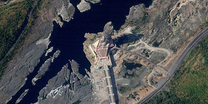
Planet Snapshots Issue 83: World’s Largest Constructions [link]
In this week’s issue:
Some of the world’s largest constructed objects
Rains in Mali
Tioga Pass in Yosemite

Atmospheric Carbon Dioxide Tagged by Source [link]
“Carbon dioxide (CO2) is the most prevalent greenhouse gas driving global climate change. However, its increase in the atmosphere would be even more rapid without land and ocean carbon sinks, which collectively absorb about half of human emissions every year. Advanced computer modeling techniques in NASA’s Global Modeling and Assimilation Office allow us to disentangle the influences of sources and sinks and to better understand where carbon is coming from and going to.”
Oil platform fire in Gulf of Mexico captured by GOES East satellite [link]
Interesting reads
Q&A: Catherine Nakalembe Delves into AI, Earth Observations for Agriculture in Open-Access Paper [link]
“Catherine Nakalembe, GEOG assistant professor, has recently published an open-access paper about the use of Artificial Intelligence (AI) in agriculture in Sub-Saharan Africa in Environmental Research Letters.”
Paper: Considerations for AI-EO for agriculture in Sub-Saharan Africa [link]
Dr. Nakalembe is an Assistant Professor at the University of Maryland, the Africa Program Director under NASA Harvest, and a member of the NASA SERVIR Applied Sciences Team on which she serves as the Agriculture and Food Security Thematic Lead.
EROS 50th History Stories
Follow the history of USGS’s Earth Resources Observation and Science EROS Center through this series of articles, starting from 1966 to present day.
EROS 50th History, 1966–1979: How Sious Falls Ingenuity Secured the Center [link]
EROS 50th History, 1980–1999: Through Uncertainty to a Firm Footing [link]
EROS 50th History, 2000–2023: Data and Science Surge [link]
Drying Up In A Flash: What Satellite Data Can Tell Us About Flash Drought Risks And The Regions We Should Be Watching [link]
“Worldwide, drought is arguably the largest overall antagonist farmers face. According to the Food and Agriculture Organization of the UN, the impact of drought is especially painful for agriculture in low-income and less-developed countries, where more than 34% of all agricultural losses can be traced to drought. The threat of drought is becoming even harder to predict, as well. A recent study showed droughts that form in just weeks — dubbed flash droughts — are increasing in frequency and speed. The ratio of fast to slow-developing droughts increased over 74% over the last few decades.”
A look at the ways in which satellites are used to monitor and forecast weather [link]
“In recent years, the use of satellites has revolutionized meteorology, enabling the observation of weather patterns on a global scale. This advancement has led to more accurate predictions than ever before — not to mention more timely warnings of dangerous conditions.”
Upcoming Events
EOA Webinar: Using space-based Earth observations to understand and tackle the climate challenge [link]
“A webinar to provide the Australian Earth observation (EO) community with an overview of the current and predicted future capabilities of EO to contribute high value climate data. This will also be the start of an ongoing conversation about Australia’s strengths and how we can best contribute globally to climate data supply, access and analysis.”
Wednesday, July 26, 2023
12:30 PM 1:30 PM
Learning
The recording and slides for the latest EUMETSAT short course on wildfire monitoring are now online! [link]
Recording of the 4-hour geemap workshop at the SciPy Conference 2023 [link]


