Level-2 News
UP42 adds ICEYE SAR data and launches the UP42 ArcGIS Pro Add-in
Earlier this month, UP42 announced the addition of ICEYE data, giving users the ability to both access the ICEYE archive and order new acquisitions through UP42’s tasking platform.
And keeping up the pace, UP42 launched the UP42 ArcGIS Pro Add-in. With this, users can access their UP42 data directly from ArcGIS Pro.
A colourful composite image of Mississippi River from multi-temporal Sentinel-1 acquisitions [link]
“The area pictured here shows where the Mississippi straddles the states of Louisiana and Mississippi. The image combines three radar acquisitions from the Sentinel-1 mission taken 12 days apart to show changes in crop and land conditions over time. Bright colours in the image come from changes on the ground that have occurred between acquisitions.”
NASA Extends Contract with Planet [link]
NASA extended its contract with Planet under the Commercial SmallSat Data Acquisition (CSDA) Program through September 2023. Under the CSDA Program, researchers can access the entire archive of PlanetScope 3–5m imagery with a 30-day latency period, and the full RapidEye 6m imagery archive, spanning from 2009 to 2019. (for details follow this link)
Sentinel-5P celebrated it’s 5th year anniversary! [link]
“To celebrate the five year anniversary of Copernicus Sentinel-5P — with its launch of 13 October 2017 — the following is a special infographic, highlighting important facts and achievements of the mission, after its first five years of operations.”
TRUTHS awaits for funding decisions at ESA’s upcoming Council Meeting at Ministerial Level [link]
“TRUTHS has been approved as part of Earth Observation Programme proposal for the upcoming ESA Council Meeting at Ministerial Level.
TRUTHS will be a ‘standards laboratory in space’, setting the ‘gold standard’ for climate measurements. The satellite, built by ESA on behalf of the UK, will host two main instruments: the Cryogenic Solar Absolute Radiometer and the Hyperspectral Imaging Spectrometer as well as the novel onboard calibration system.”
“With spectrometer resolution sensors of unprecedented accuracy, TRUTHS can observe climate-relevant processes related to the atmosphere, the oceans, and the land surface. TRUTHS’ observations will test and advance the development of climate models, allowing more accurate climate change hindcasting and forecasting.”
“In addition, it will provide reference calibration to other optical sensors operating in the spectral range 320 to 2400 nm, including amongst other ‘new space’ sensors and the future GHG constellation, improving their performance and interoperability.
Follow the links below for more details:
A benchmark for climate data [link]
TRUTHS mission [link]
Traceable Radiometry Underpinning Terrestrial- and Helio-Studies (TRUTHS): An Element of a Space-Based Climate and Calibration Observatory [link]
MISSION SUMMARY — TRUTHS [link]
TRUTHS Introduction (Slides, NPL, UK Space Agency) [link]
Developer’s Orbit
Access 401 Earth Observation Datasets
In a recent paper titled “EarthNets: Empowering AI in Earth Observation”, Xiong et al. reviewed and organized 401 publicly published Remote Sensing datasets. You can list and query datasets using several filters (per domain, task, application, resolution, etc) here.
Furthermore, they developed a Python library called Dataset4EO as a standard and easy-to-use dataset loading library. Dataset4EO works out-of-the-box with PyTorch’s Dataloader and, at the moment, users can access about 15 datasets. In the code snippet below, they show how to use Dataset4EO to download the Landslide4Sense dataset.
from Dataset4EO.datasets import list_datasets, load, landslide4sense
from torch.utils.data import DataLoader2
from tqdm import tqdm
# list all the supported datasets
print(list_datasets())
# Create new dataset object by calling:
datasets_dir = './'
dp = landslide4sense.Landslide4Sense(datasets_dir, split='train')# Then the corresponding dataset will be downloaded and decompressed automatically# Create a dataloader by calling:
data_loader = DataLoader2(dp.shuffle(), batch_size=4, num_workers=4, shuffle=True, drop_last=True)# Iterate through the dataloader
for it in tqdm(data_loader):
print(it)This collection is part of the broader EarthNets platform, where users can find both datasets and Deep Learning models. The platform as a whole was designed as a way to make it easy for researchers to apply novel deep learning models to Remote Sensing datasets.
NOTE: We can clearly see a few trends: for example, as the Remote Sensing community started adopting the use of Deep Learning methods, datasets became larger! The Functional Map of the World (fMoW) and Sen4AgriNet datasets are larger than 4000GB!
For more details, read their paper here.
Featured Use-case
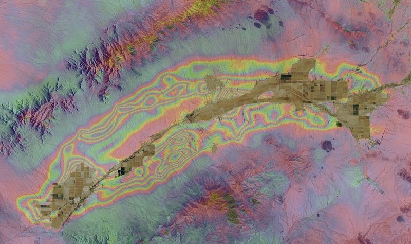
Arizona Department of Water Resources Land Subsidence Monitoring Program Using InSAR Data through ASF’s OpenSARLab [link]
The Arizona Department of Water Resources has been monitoring land subsidence using InSAR since 2002. Up until early this year, data storing, processing and analysis was done in-house but after losing 70 terabytes of SAR data in February 2022 they decided to migrate their workflows to ASF’s OpenSARLab.
Follow the links below to read more about their land subsidence monitoring program.
Mapping Displacement and Subsidence: ADWR Land Subsidence Monitoring Program Using INSAR Data (YouTube) [link]
Arizona’s Land Subsidence Monitoring Program (Slides) [link]
ADWR InSAR Program Fact Sheet [link]

Learning
NASA’s Applied Remote Sensing Training (ARSET) [link]
Follow this online resource guide!


