

Level-2 News
SpaceX Delivers 72 Spacecraft to Orbit in Transporter-8 Rideshare Mission [link]
“SpaceX delivered 72 spacecraft to orbit on Monday in the Transporter-8 launch, its eighth mission in its dedicated smallsat rideshare program.
The mission launched Earth observation satellites for a variety of customers including Satellogic, with four NewSats Mark-V spacecraft; four third-generation satellites for Iceye; and the third hyperspectral satellite for Orbital Sidekick in the planned GHOSt constellation.”
Capella Space Awarded Multi-Year Blanket Purchase Agreement by NASA [link]
Capella Space has been awarded a five year blanket purchase agreement (BPA) by NASA’s Earth Science Division for the purchase of its high resolution SAR imagery and data for evaluation to determine their suitability for advancing NASA’s science and application goals.
Tomorrow.io raises $87 million for weather satellite constellation [link]
“Tomorrow.io raised $87 million in a Series E funding round to support its campaign to gather weather and climate data.
Tomorrow.io launched its first radar satellite, R-1, April 15.”
Hydrosat acquires IrriWatch [link]
“Hydrosat, a Washington-based thermal data and analytics company, announced the acquisition June 8 of IrriWatch, a Netherlands company that delivers daily climate, crop, soil and irrigation updates to farmers in 62 countries. Details of the transaction were not disclosed.”
SkyFi and Near Space Labs Forge Strategic Partnership to Expand Access to High-Resolution Imagery into the Consumer Market [link]
Near Space Labs announced its strategic partnership with SkyFi. This collaboration will give SkyFi users access to Near Space Labs’ 10 cm resolution imagery.
Ordnance Survey to Protect Peatlands in North England [link]
“Ordnance Survey (OS) is working with Natural England and Durham University to help produce a detailed carbon model for Thorne and Hatfield Moors, part of Humberhead Peatlands National Nature Reserve in the North of England.
OS’s technical experts have been using geospatial data and Earth observation (EO) data to analyse the current condition of peatland. This baselining technique could be rolled out nationwide to facilitate access to investment for large-scale peatland restoration projects from carbon markets.”
Developer’s Orbit
RapidAI4EO Corpus Tutorial [link]
“The RapidAI4EO corpus is a large dataset of analysis ready satellite time series imagery originally designed for land use and land cover (LULC) classification and change detection, but applicable to a wide range of research topics in remote sensing and machine learning. The corpus is sampled at 500,000 locations across Europe, with a time series of coincident Planet Fusion and Sentinel-2 imagery and multiclass LULC labels derived from the 2018 CORINE Land Cover (CLC) inventory, available at each location.”
Data
KOMPSAT-1 Coverage of 50 European Cities Collection Accessible to Users [link]
“The European Space Agency (ESA) is announced the availability of the KOMPSAT-1 Coverage of 50 European Cities collection to users as part of the Earthnet’s Third Party Mission Programme.
KOMPSAT-1, also known as Arirang-1, was a South Korean Earth observation satellite launched on December 21, 1999. Operating for a remarkable eight years, the satellite ceased operations on December 30, 2007, following a loss of contact.”
Snapshots

Full scale of flooding in Ukraine’s Kherson oblast captured by ICEYE analysis [link]
Related:
Navigating The Kakhovka Dam Collapse: NASA Harvest Consortium Assesses Agriculture Impacts With Satellite Imagery [link]

Earth from Space: Cook Strait, New Zealand [link]
“Named after James Cook, who was the first European to sail through it, the Cook Strait is just 23 km wide at its narrowest point, so on a clear day it is possible to see across the strait. However, it is also renowned as one of the roughest and most unpredictable stretches of water in the world, owing to strong winds, conflicting currents and variable tides.”

Planet Snapshots Issue 79: Lakes [link]
In this week’s issue:
Unique and changing lakes
Wildfires turn Northeast America hazy
Satellites spot a spotted lake
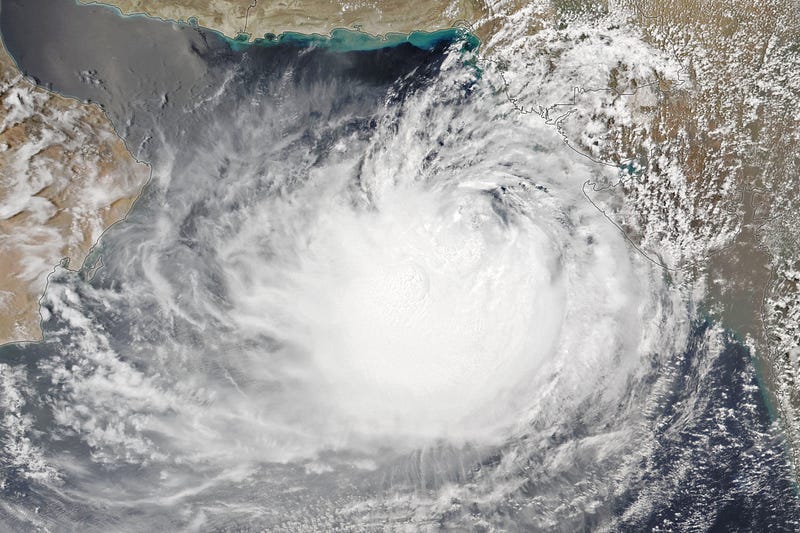
Cyclone Biparjoy Churns Toward India and Pakistan [link]
“After stirring in the Arabian Sea for over a week, Cyclone Biparjoy neared the coastline of western India and southern Pakistan in June 2023.”
Interesting reads
Forecasting fires with SMOS [link]
“As the current wildfires in Canada show, climate change is increasing the risk and extent of wildfires across the globe. ESA, along with the European Centre for Medium-Range Weather Forecasts have taken a new approach by using realtime observations from ESA’s Soil Moisture and Ocean Salinity satellite mission to better anticipate the outbreak of fires.”
