Level-2 News
Celebrating 25 years of Copernicus [link]
“For a quarter of a century, the EU’s Earth Observation programme has been providing vital data for Climate Change, disaster management, and environmental protection.”
Related:
25 years of Copernicus [link]
25 times Copernicus made the headlines [link]
Radiant Earth Collaborating with Columbia University to Support Climate Scientists [link]
Radiant Earth havs entered into an agreement with Columbia University’s Lamont-Doherty Earth Observatory to expand access to climate data.
ESA & Planetek Hellas sign €1 million contract for greek secure connectivity and eo cubesat [link]
Planetek Hellas, has signed a €1 million contract with the European Space Agency (ESA) for the design, assembly, integration, testing, launch, and operation of a CubeSat.
The CubeSat’s primary mission objective is to provide secure connectivity using a state-of-the-art in-orbit laser terminal. The selection of the proper ground station when passing over the Greek territory will be the result of on-board cloud classification.
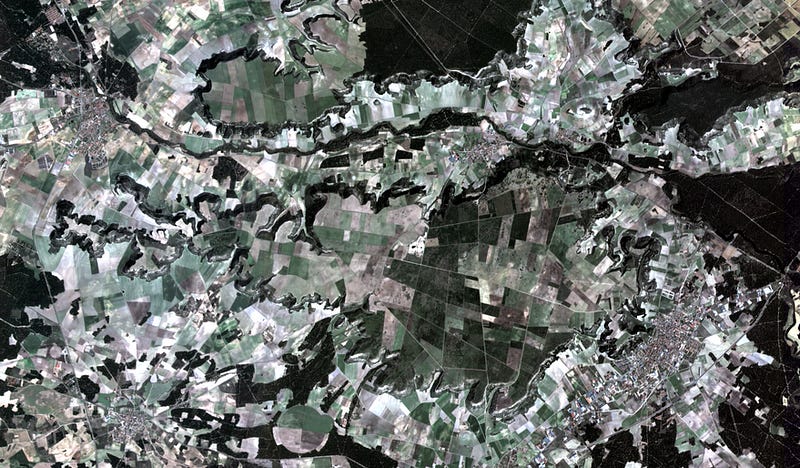
Lots of new functionality in the Green Transition Information Factory (GTIF) demonstrator V1.0 release, including e.g. S1/S2-based dynamic hydro-reservoir monitoring [link]
EOS Data Analytics is acquiring imagery from the first satellite in the Silicon Valley company’s agriculture-focused constellation [link]
“By the end of June, EOSDA expects to begin selling EOS Sat-1 imagery commercially and offering priority tasking for customers in the United States, Canada, Southeast Asia and Australia. Imagery and analytics combined in products aimed at the agriculture market will be available in July, said Rim Elijah, EOSDA vice president of sales.”
Google leads $36 million funding round for Pixxel [link]
“Hyperspectral imaging startup Pixxel raised $36 million in a Series B funding round led by Google.
Pixxel announced June 1 the Series B round, which included Google as well as existing investors Radical Ventures, Lightspeed, Blume Ventures, growx, Sparta and Athera. The company, which did not disclose the valuation of the round, has now raised $71 million.”
UK Space Agency Backs Satellite Applications Catapult, GHGSat Partnership for Methane Emissions Data Access [link]
“Satellite Applications Catapult and GHGSat have formed a partnership to open an international analytics center co-located in London and Edinburgh and provide satellite data on global methane emissions for research and development purposes in the United Kingdom. The partnership will be financed with £5.5 million ($6.8 million) in funding from the UK Space Agency.”
NUVIEW Advances Support Towards Climate and Environmental Mission [link]
“NUVIEW, an Earth observation company focused on geospatial technology, announced investor support from actor and environmentalist Leonardo DiCaprio who joined the consortium of investors, led by MaC Venture Capital, along with Broom Ventures, Cortado, Florida Funders, Industrious, Liquid2, and Veto Capital to help build the world’s first commercial LiDAR, light detection and ranging, satellite constellation. NUVIEW seeks to map the Earth’s entire land surface in real 3D for the first time and then repeating it annually.”
Agrograph and Planet Labs Partner to Deliver Enhanced Agros™ Insights [link]
“Agrograph announced a new partnership with Planet Labs PBC to integrate Planet’s high-resolution global satellite data with Agrograph’s expert geospatial data technology to comprehensively support clients’ need for data-driven business and farm-risk management decisioning tools.”
Developer’s Orbit
Continental-scale crop type mapping in openEO platform [link]
Follow this post for how a team from OpenEO produced a continental scale croptype map using 11000 COG files.
Data
Introducing Earth Search v1: New datasets now available [link]
“Element 84 maintains a catalog of Sentinel-2 and Landsat data available at the Earth Search endpoint. Within the last few months they’ve expanded the number of open collections on Earth Search, a catalog of data available on AWS, to further extend the API’s impact.”
Tree Canopy Cover product added to National Land Cover Database [link]
“A newly released Tree Canopy Cover product adds a helpful layer of information to the definitive land cover product National Land Cover Database (NLCD), generated at the USGS Earth Resources Observation and Science (EROS) Center in partnership with other agencies.”
Snapshots
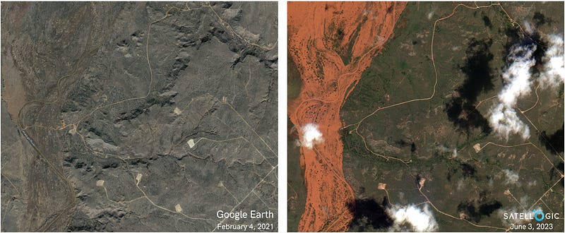
Unveiling Ground Truth: SkyFi Captures Near Real-Time Imagery of a Texas Flood [link]
“In the image, the Canadian River swells beyond its banks, swallowing vast areas with its relentless power. The water, murky and overwhelming, engulfs roads, campsites, and vast stretches of land.”
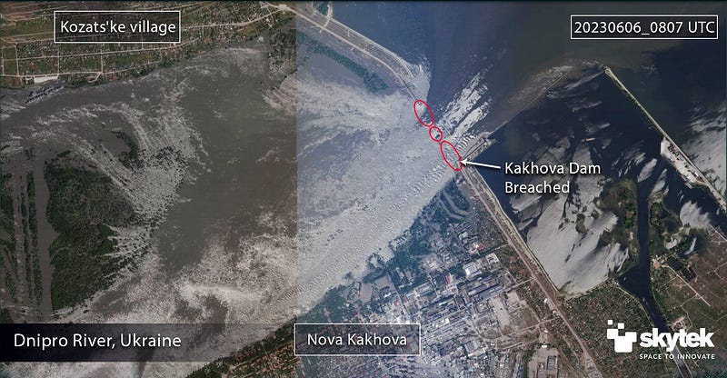
Kakhovka Dam, Ukraine Destruction [link]
“Satellite imagery taken from Planet and analysed by Skytek indicate that a large explosion destroyed over 60% of the dam which is built 30m tall and 2,2 km long across Dnipro River, allowing the water contained in the Kakova Reservoir flow uncontrolled down river.”
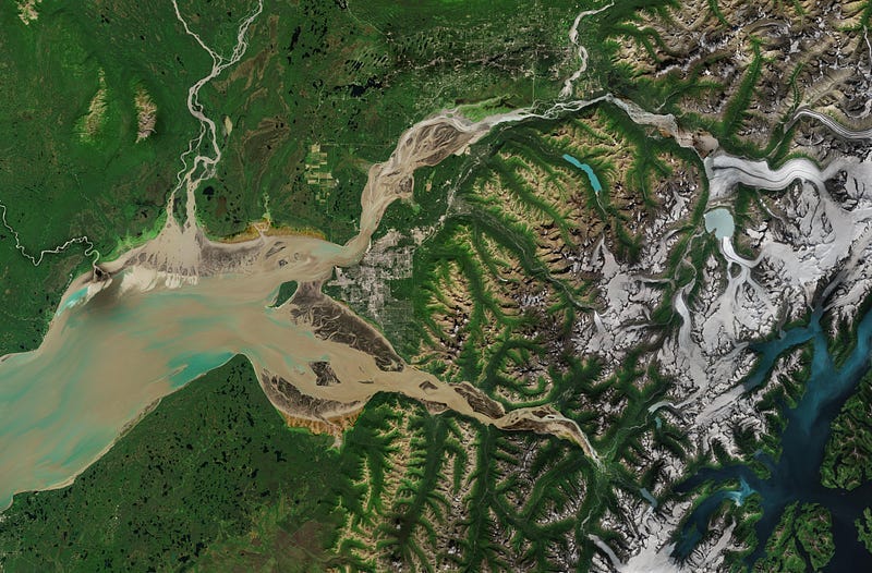
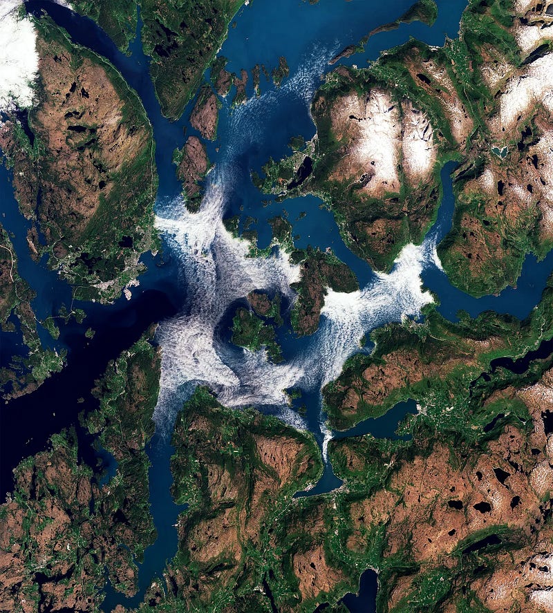
Earth from Space: Anchorage, Alaska [link]
“From the Chugach Mountains on the right to the Cook Inlet on the left, this Copernicus Sentinel-2 image features the varied landscape surrounding Anchorage, the largest and most populous city in the state of Alaska in the United States.”
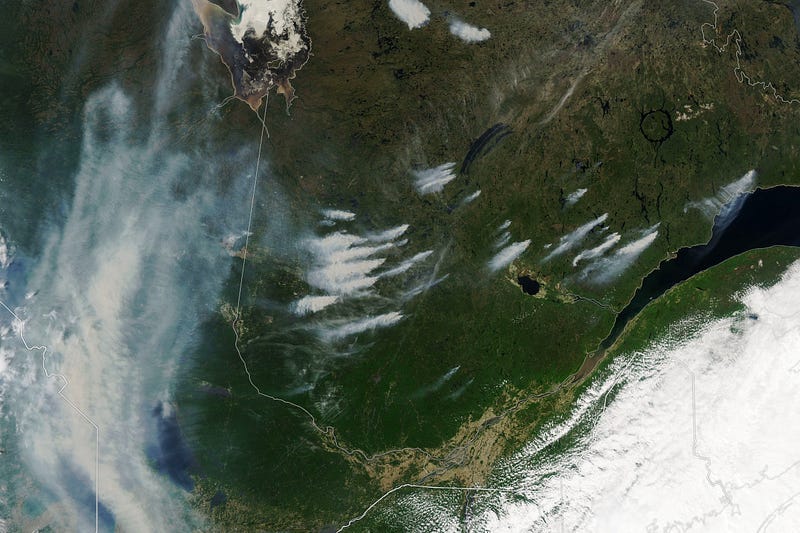
Fires Burn Across Quebec [link]
“An unusually intense start to Canada’s wildfire season filled skies with smoke in May 2023. Then, at the beginning of June, scores of new fires raged in the eastern Canadian province of Quebec, some of which were ignited by lightning.”
Planet Snapshots Issue 78: Geoparks [link]
In this week’s issue:
UNESCO announces new geoparks
Vibrant sights between sand bars
Manhattan-sized logjam in Canada
Interesting reads
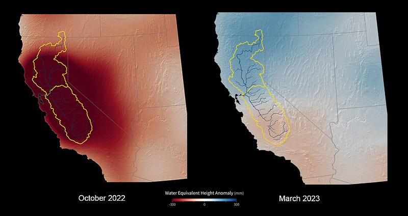
US-German Satellites Show California Water Gains After Record Winter [link]
“Early data shows the greatest net gain of water over the winter in nearly 22 years, but the state’s groundwater levels still suffer from the effects of years of drought.”
A Revolution is Coming in Satellite Imagery: Why 30cm Satellites are Set to Transform the Industry [link]
“With the current (limited) satellites that are in orbit, you can observe a given location 2–3 times a day with 30–50cm imagery as long as there is no cloud coverage. This is useful, but it’s not enough for many advanced use cases. If users could see this data every couple of minutes, it would blow open the industry and catalyze a plethora of new commercial use cases. That’s where 30cm satellites come in.”
Podcasts
Eyes on Earth Episode 95 — EROS 50th: Landsat Science Team [link]
“In this episode, we learn how members have explored strategies for the effective use of archived Landsat data and integration of future data, and how they have helped identify Landsat user needs for upcoming satellite sensors, including those on the future Landsat Next.”
Upcoming Events
12th Advanced Training Course on Land Remote Sensing [link]
“The European Space Agency (ESA) is organising an Advanced Training Course on Land Remote Sensing with the focus on Hydrology and Hazards in collaboration with the Wrocław University of Environmental and Life Sciences. This course is dedicated to train the next generation of Earth Observation (EO) scientists and experts, working in the domains of hydrology or related hazards, in using data from Copernicus Sentinels and other satellite missions for science and applications development.
The course will take place from September 25th to 29th, 2023, at the Wrocław University of Environmental and Life Sciences in Poland.”
Learning
ICRW conference workshop recording now available — An Introduction to Watershed Analysis with Leafmap and WhiteboxTools [link]