Level-2 News
First images of EOS SAT-1 satellite processed by Deimos [link]
“EOS SAT-1 is the first of the 7-satellite EOS SAT agri-focused constellation powered by EOS Data Analytics. The satellite was launched in January 2023, and the first image, disclosed in May 24th, has been produced as part of the initial commissioning activities.
The first satellite’s pan-sharpened images have a resolution of 1.5 meters and cover a total area of 2,550 square kilometers in the Spanish province of Segovia.”
EarthDaily Analytics offers VENµS imagery access [link]
“Vancouver-based EarthDaily Analytics is offering access to the French-Israeli Vegetation and Environment monitoring on a New Micro-Satellite mission, called VENµS, through Amazon Web Services.”
Iceye introduces Dwell imaging mode [link]
“Iceye unveiled a new imaging mode that distinguishes human-made from natural objects and highlights moving vehicles.
For Dwell mode, satellites focus on an area for 25-seconds. Iceye’s traditional imagery is derived from 10-second views.”
Impact Observatory unveils IO Monitor [link]
“Impact Observatory unveiled an early access program May 22 for IO Monitor, a global mapping and monitoring product.
For $1 per square kilometer customers can obtain access to IO Monitor, which pairs artificial intelligence with satellite imagery to classify land use and land cover. The minimum order size is 5 square kilometers.”
Orbital Sidekick acquires first light imagery [link]
“Hyperspectral startup Orbital Sidekick is acquiring imagery from its first two satellites launched in April on the SpaceX Transporter-7 rideshare flight.”
SkyFi lets you order up fresh satellite imagery in real time with a click [link]
“SkyFi has parthnered with over a dozen companies to deliver various kinds of satellite images — including optical, synthetic aperture radar (SAR), and hyperspectral — directly to the customer via a web and mobile app. A SkyFi user can task a satellite to capture a specific image or choose from a library of previously captured images. Some of SkyFi’s partners include public companies like Satellogic, as well as newer startups like Umbra and Pixxel.”
Related: SkyFi Closes $7M Seed Round [link]
Developer’s Orbit
You can now download or work with user defined extents of
ESA_WorldCereal crop map products in openEO Platform! [link]
For more, follow this notebook.
Snapshots

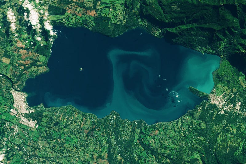
Algae in the Andes [link]
“Bursts of phytoplankton are appearing in oceans, seas, gulfs, canals — and increasingly in lakes.
In a recent study using Landsat imagery, Rodríguez-López estimated the amount of chlorophyll-a, an indicator of algal blooms, on Lake Villarrica from 2014 to 2021. She found that despite the lake’s overall good water quality, chlorophyll-a values spiked close to shore and near the cities of Villarrica and Pucón.”
Planet Snapshots Issue 76: Faults [link]
In this week’s issue:
When plates collide
Spring thaw and fall foliage
Waterfalls: two real, one fake
Mocha Cyclone Damages in Myanmar [link]
“Rhakine State in West Myanmar was hit by the Cyclone Mocha on Sunday, 14th May. The aftermath of the hurricane in the city of Sittwe and along the coast can be observed in the following two before-and-after Pléiades Neo images.”
Interesting reads

A Global Biodiversity Crisis: How NASA Satellites Help Track Changes to Life on Earth [link]
“Climate change plays an increasing role in the global decline of biodiversity — the variety of life on Earth. Scientists use NASA data to track ecosystem changes and to develop tools for conserving life on land, in our ocean, and in freshwater ecosystems.”
Cocoa planting is destroying protected forests in west Africa, study finds [link]
“Satellite maps of Ivory Coast and Ghana showed swathes of formerly dense forest had become cocoa plantations since 2000, according to a study.
The researchers combined cocoa plantation data with publicly available satellite imagery in a deep learning framework and created high-resolution maps of cocoa plantations for both countries, validated in situ. Their results suggest that cocoa cultivation is an underlying driver of over 37% of forest loss in protected areas in Côte d’Ivoire and over 13% in Ghana, and that official reports substantially underestimate the planted area (up to 40% in Ghana).”
Paper: Cocoa plantations are associated with deforestation in Côte d’Ivoire and Ghana [link]
Hyperspectral Imaging Attracts a Host of Space Startups [link]
“Better high-res imaging, smaller satellites are creating opportunities for commercial satellite companies to capitalize on tasks such as monitoring agriculture and tracking climate change.”
Upcoming Events
Surface Soil Moisture products at continental scale [link]
“The webinar will give an overview of high-resolution (1 km) satellite soil moisture data sets available at continental to global scale. These data sets are either derived by downscaling coarse resolution data from passive (SMAP, SMOS, AMSR2) and active (ASCAT) microwave sensors using optical or Synthetic Aperture Radar (SAR) data, or by deriving the soil moisture data directly from only the SAR data. The presentation will focus on the latter type of products, explaining how soil moisture data can be derived from Sentinel-1 SAR time series, and how these data might be used for monitoring rainfall and irrigation.”
DATE: June 13, 2023, 14:00 CET
Podcasts
TerraWatch Space Podcast #70
L-Band Synthetic Aperture Radar: Commercial Applications & Market Potential — Asterra [link]


