Level-2 News
Spain’s Satlantis expands into thermal imagery with UK investment [link]
“Spanish Earth observation satellite provider Satlantis has bought a majority stake in British university spin-out SuperSharp to expand into the thermal imaging market.
SuperSharp is developing a foldable thermal infrared telescope that would enable satellites as small as 12U, or the size of 12 cubesats, to provide images with a 6-meter ground sampling distance.”
BlackSky Reseller Telespazio to Provide Disaster Response Imagery Service in Spain [link]
“The deal will support the Government of Aragon and the Geographic Institute of Aragon (IGEAR) with high-cadence, low-latency imagery services for crisis response.
The imagery will be used in responses to various crisis situations including fires, floods, and other natural disasters.”
Synspective and Thaicom Partner on Disaster Response in Southeast Asia [link]
“In another deal on disaster response, imagery startup Synspective and regional operator Thaicom are partnering to jointly offer synthetic aperture radar (SAR) for disaster response in Thailand.
The companies said the service will be applicable to disaster response, environmental monitoring, agricultural productivity, and infrastructure planning.”
Satellite captures up-close look at NASA’s Landsat 8 spacecraft in orbit [link]
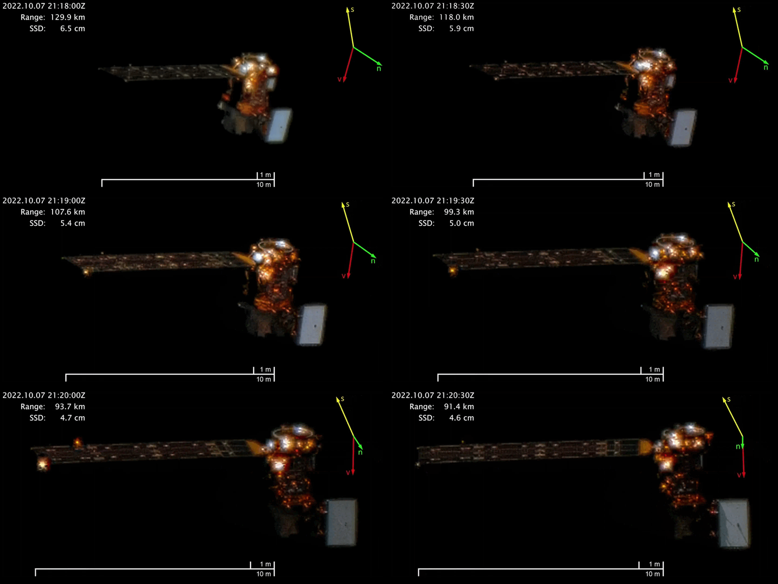
“Maxar Technologies’ Worldview-3 satellite has delivered images of NASA’s Landsat 8 spacecraft from ranges of between 56 miles (91.4 kilometers) and 80 miles (129.9 km), showing clear details of the powerful Earth-observation satellite.”
Developer’s Orbit
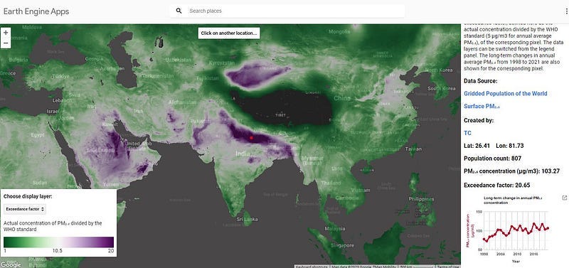
Creating Web Applications using Google Earth Engine [link]
Check out this community tutorial by Tirthankar Chakraborty on creating a web applications using Google Earth Engine platform’s JavaScript API. The global gridded air pollution (PM2.5) dataset is used as an example.
The tutorial covers basemap stylization, custom layer selections, inspectors, and basic data visualization.
Data
S1SLC_CVDL Dataset [link]
“The S1SLC_CVDL dataset comprises 276,571 patches (100×100 pixel) of Single Look Complex (SLC) StripMap (SM) Sentinel-1 (S1) CV-SAR data, derived from three scenes acquired over Chicago and Houston in the Uniate States, and Sao Paulo in Brazil in May 2021.”
The semantic labels are provided as the numeric format as following:
Agricultural fields (AG)
Forest and Woodlands (FR)
High Density Urban Areas (HD)
High Rise Buildings (HR)
Low Density Urban Areas (LD)
Industrial Regions (IR)
Water Regions (WR)
Snapshots
Biodiversity: Pléiades Neo Coverage of the Namib Desert [link]
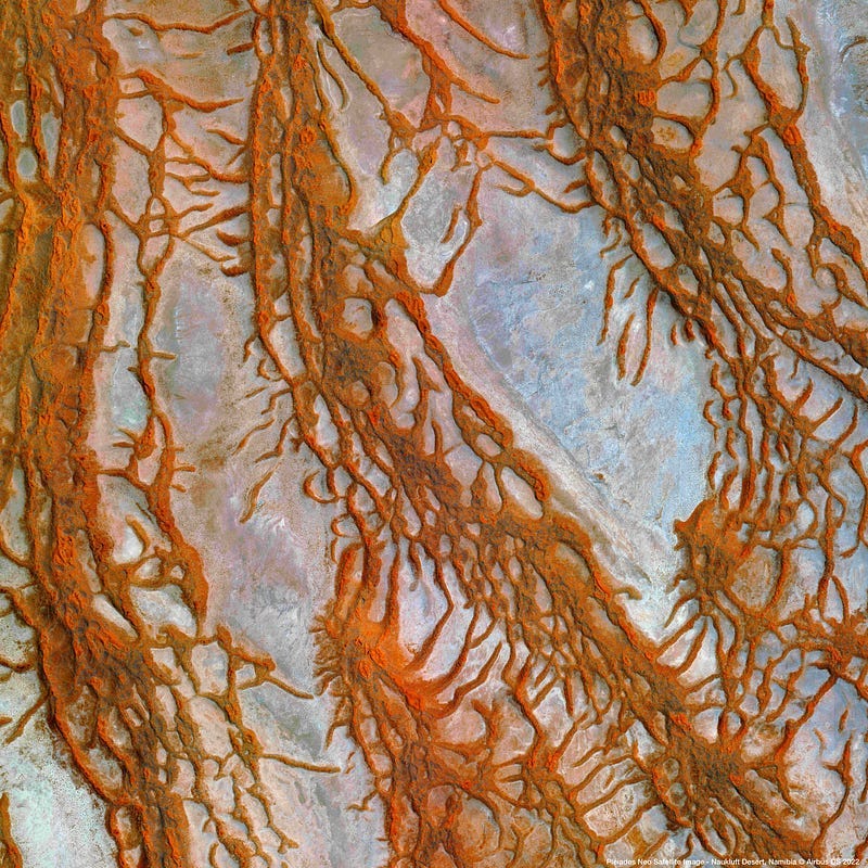
“With its area of almost 50,000 km², the Namib-Naukluft National Park is larger than Switzerland. The aridity of the region builds unique landscapes. It offers an exceptional spectacle with the highest dunes in the world (almost 300 m high) and mountains with blood-red tones of dry savannah.”

Earth observation data show snow deficit in the Alps [link]
“For the second year in a row, the Alps are experiencing an exceptionally snow-free winter. EOC researchers have now examined how the snow situation in the past season compared to the last 38 years. To do this, they evaluated more than 15,000 satellite images of the entire Alpine region. The result: In the spring, the average snow line was 166 meters above the long-term average.”
Bloomin’ Atlantic [link]
“For several weeks in April 2023, swirls of green and turquoise grew more vibrant in the waters off the Mid-Atlantic coast of the United States. Some of the color is due to an abundance of phytoplankton. Though each of these floating plant-like organisms is microscopic, large groups of them are visible to satellites.”
Planet Snapshots Issue 73: Sand [link]
In this week’s issue:
The sand shortage and new opportunities
Volcanoes paired with glaciers
Interesting reads
We Don’t Talk About Open Data [link]
Read this refreshing article by Jed Sundwall, the Executive Director of Radiant Earth Foundation about his thoughts on open data.
In that, he challenges the current definition and practices and proposes a different framework and way of thinking of open data products, while trying to accommodate different use cases regarding data availabily and access.
On Earth Day, 5 Ways AI, Accelerated Computing Are Protecting the Planet [link]
“From climate modeling to endangered species conservation, developers, researchers and companies are keeping an AI on the environment with the help of NVIDIA technology.”
Upcoming Events
Workshop on AI4EO for Natural Hazards Management [link]
“Hybrid mini-workshop dedicated to the use of Artificial Intelligence (AI) for Managing Natural Hazards.
Includes talks from distinguished speakers on Deep Learning Data Pipelines for EO, Causality, Probabilistic ML, Explainable AI, Graph Neural Networks, Ecosystem Modeling. The workshop covers a variety of applications on disaster management where AI can help, namely wildfire forecasting, volcanic unrest detection and landslide detection.”
The workshop is co-organized by ESA Φ-lab, the National Observatory of Athens, Harokopio University of Athens and Max Planck Institute of Biogeochemistry.
May 10 2023 14h00–17h30 CEST
Register to receive an MS Teams link to join.
Learning
Why simulate Synthetic Aperture Radar (SAR)? [link]
Follow this post from Michael Blazej about generate SAR imagery.


