Level-2 News
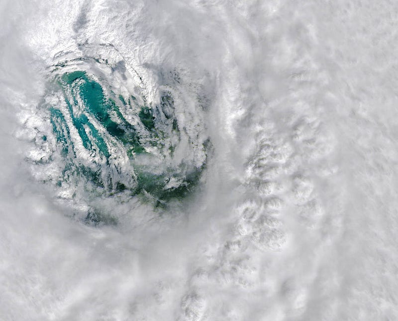
Staring Into Ian’s Eye
Hurricane Ian as seen from GOES-16, Landsat-8, MODIS, VIIRS. Collecting different types of data from multiple sensors is vital to improve weather prediction systems and support disaster management and damage assessment, by providing rapid-response information.

The Nord Stream Gas Pipeline rupture as seen from space
“The ruptures on the Nord Stream natural gas pipeline system under the Baltic Sea have led to what is likely the biggest single release of climate-damaging methane ever recorded.”
The rupture near Bornholm Island, Denmark, was captured by a Planet Dove on September 26, 2022.
The same rupture was seen by Sentinel-1 on September 29, 2022
And GHGSat, a company that provides satellite monitoring of greenhouse gases in high-resolution, estimated the emission rate.

Preparations for the first satellite of Europe’s Meteosat Third Generation (MTG) satellite system to be launched in December
The first MTG satellite (MTG-I1), is on its way to Kourou, French Guiana, ahead of its December launch.
MTG is one of the most complex and innovative meteorological geostationary satellite systems ever built. It consists of three satellites in geostationary orbit and is designed as a follow-on to the Meteosat Second Generation (MSG) series, ensuring the continuity of high-resolution weather monitoring beyond 2040. MTG will revolutionize storm prediction, enhance weather forecasts, extend climate records, and provide a wide range of essential observations.
For more details about MTG and mission facts, check this and MTG-I1's long journey to the skies.
ESA selects Harmony as tenth Earth Explorer mission
Harmony will comprise two identical satellites orbiting Earth in convoy with a Copernicus Sentinel-1 satellite. Each Harmony satellite will carry a receive-only synthetic aperture radar and a multiview thermal-infrared instrument.
Together with observations from Sentinel-1, Harmony will deliver a wide range of unique high-resolution observations of motion occurring at or near Earth’s surface.
Harmony will help study deformation and flow dynamics at the rapidly changing ice-sheet edges, observe the motion of mountain glaciers and measure small shifts in the shape of the land surface. Harmony looks for launching in 2029.
Cryosat avoids collision
On Sunday, Cryosat performed a collision avoidance manoeuvre to dodge a 18cm shard of space debris.
The previous manoeuvre to avoid space debris was performed by Sentinel–1A in May earlier this year, when Mission Control had its orbit altered by 140m to prevent collision. Check this Twitter thread for more.
This certainly wasn’t the last time for such action, as active satellites need to avoid both decades old space debris and the increasing traffic in low-Earth orbit.
Follow the links below for more:
Dodging debris to keep satellites safe
ESA’s Space Environment Report 2022

Competitions
“Seize the beauty of our planet” contest by CloudFerro
“We are looking for the best satellite images depicting either an area of ocean/deep seas or surface water or their surroundings that have been in any way affected by climate change or human impact. The images should be generated on one the platforms CloudFerro developed and operate.”
Check the contest page for more details.
The Developer’s Orbit
Crop Yield Prediction Using Deep Neural Networks
Read about Omdena’s project on crop yield prediction using deep neural networks in Senegal, Africa. As part of that, they built an interactive Jupyter notebook-based interface using Geemap and deployed it using Voila.
Learning
Sentinel-1 Technical Series from Descartes Labs
A series of technical posts about Sentinel-1, processing SAR data and building SAR and InSAR-derived products. (There are six posts published at the time of this writing. Keep an eye for more on Descartes Labs’ blog).
Sentinel-1 at Descartes Labs: An Overview
Sentinel-1 Technical Series Part 1 | Burst Mapping: Random Seeks into PB Scale Non Cloud-Optimized Data Archives
Sentinel-1 Technical Series Part 2 | SAR Geocoding: Working with SAR and InSAR data in geospatial frameworks
Sentinel-1 Technical Series Part 3 | Global scale InSAR
SAR Technical Series Part 4 | Sentinel-1 global velocity layer: Using global InSAR at scale
Sentinel-1 Technical Series Part 5 | Targeted analysis


