
Level-2 News
Greece opens €69m HELLAS-SPACE 2.0 tender for three VHR optical satellites [link]
Greece has launched the first tender under HELLAS-SPACE 2.0, seeking three optical Earth observation satellites capable of imaging at up to 30 cm resolution. The €69 million procurement is being run through ESA, with bids due on 23 December. A separate tender for thermal satellites is planned for later in November.
NASA outlines STRIVE mission for detailed upper-atmosphere observations [link]
Planned for launch in 2030, STRIVE would use two limb-viewing instruments to measure temperature, ozone, trace gases, aerosols and clouds through the upper troposphere and stratosphere. The mission aims to collect more than 400,000 atmospheric profiles a day, with 1 km vertical resolution.
OHB awarded €554m contract for Sentinel-3 Next Generation Topography [link]
ESA has awarded OHB a €554 million contract to develop the first Sentinel-3 Next Generation Topography satellite, with an option for a second. The new altimetry mission will continue measurements of ocean surface height, inland waters and ice, building on Sentinel-3 and Sentinel-6.
France awards €1.5bn-plus IRIS military observation contract [link]
France has ordered two next-generation military optical satellites from Airbus Defence and Space and Thales Alenia Space to replace its existing CSO spacecraft. Worth more than €1.5 billion, the contract includes the satellites, ground systems and operations through the late 2030s. IRIS is designed to provide higher-resolution imagery with faster delivery.
Hydrosat announces Nyktòs mid-wave infrared satellite programme[link]
Hydrosat is developing Nyktòs, a taskable mid-wave infrared imaging system for day-and-night tactical intelligence, surveillance and reconnaissance. The programme will complement its wider-area Osiris thermal constellation, with new European manufacturing facilities and supply-chain partnerships planned.
Planet signs multi-launch deal for Stoke Space’s Nova rocket [link]
Planet has signed an agreement for multiple launches aboard Stoke Space’s fully reusable Nova rocket. The flights will support deployment and replenishment of Planet’s Earth observation fleet from Cape Canaveral.
Synspective books up to ten Firefly Alpha launches through 2030 [link]
Firefly Aerospace will launch up to 20 Synspective StriX SAR satellites across as many as ten dedicated Alpha missions through 2030. Each flight can carry two satellites, with launches planned from both Vandenberg and Wallops.
BlackSky wins seven-figure Gen-3 imagery subscription from defence ministry [link]
An unnamed international defence ministry has signed a one-year, seven-figure contract for BlackSky’s Assured service following an initial trial.
Poland adds ICEYE flood, wildfire and river-ice monitoring [link]
Civil Security Hub Poland has subscribed to ICEYE’s flood, wildfire and river-ice monitoring services, giving emergency teams standing access without having to request a separate activation for each event. The agreement forms part of ESA’s Space Resilience Nodes initiative.
ICEYE unveils Gen5 SAR satellites with resolution as fine as 11 cm [link]
ICEYE has announced its fifth-generation SAR satellite, offering imagery as fine as 11 cm for government customers, subject to ITU regulations, and 16 cm at standard operating bandwidth. Gen5 also increases imaging time per orbit and introduces onboard AI processing capabilities.
IHI begins assembling ICEYE SAR satellites in Japan [link]
IHI has begun assembly, integration and testing of two ICEYE SAR satellites at its new Pilot Lab in Tokyo. The work is part of a four-satellite procurement agreement with ICEYE; the first two spacecraft have been providing IHI with data since April 2026.
TenneT selects Orbital Eye to monitor Dutch electricity-grid construction [link]
Dutch grid operator TenneT will use Orbital Eye’s COSMIC-EYE platform to monitor construction along the Rilland-Tilburg high-voltage connection, which includes 263 pylons. Weekly satellite-based reports will track excavation, access roads, machinery and material storage along the corridor.
Ubotica demonstrates autonomous satellite image scheduling [link]
Ubotica’s CogniSAT-6 identified a cruise ship in imagery of the Pacific Ocean and independently scheduled another observation of the same location, without instructions from the ground.
NeuralSat raises €2.9m for orbital data relay and computing network [link]
German startup NeuralSat has raised €2.9 million in pre-seed funding to develop a network for relaying and processing satellite data in orbit. The company plans its first in-orbit demonstration in 2027, followed by initial constellation launches in 2028.
SpaceComputer plans secure-computing demonstration aboard D-Orbit mission [link]
SpaceComputer will fly its Space Fabric security software with Aptos Orbital’s cEDGE computer aboard a D-Orbit ION vehicle in 2027. The demonstration will test cryptographic verification of computing performed in orbit and protection of data transmitted through the Iridium satellite network.
My read: We’re seeing a move towards more autonomous operations in LEO, with onboard processing, scheduling new observations and transferring data between satellites starting to come together. I expect more satellites to make decisions and share results without relying on ground stations at every step.
Sentinel-6B prepares to take over as sea-level reference satellite [link]
Sentinel-6B has passed its initial checks and is expected to become the reference satellite for calibrating other sea-level missions in January 2027. It currently flies about 30 seconds behind Sentinel-6 Michael Freilich, which will later move to a different orbit so the pair can collect higher-resolution ocean measurements.
iQPS satellite reaches orbit on Rocket Lab’s 100th Electron launch [link]
Rocket Lab’s 100th Electron flight deployed the YAMATSUMI-II SAR satellite for Japan’s iQPS into a 575 km orbit on 14 November. It was Rocket Lab’s eleventh successful launch for the company, which has another seven dedicated Electron missions booked through 2030.
Next Vega C launch slips towards Christmas as IRIDE satellites arrive late [link]
Avio says the next Vega C launch has moved closer to Christmas because several customer satellites arrived later than planned. The flight is due to carry six spacecraft for Italy’s IRIDE Earth observation programme.
Developer's Orbit
deck.gl-raster v0.10 speeds up COG rendering by merging tile requests [link]
Kyle Barron reports up to 4× faster Cloud Optimized GeoTIFF rendering in deck.gl-raster v0.10. The update merges nearby tile reads into fewer HTTP byte-range requests, reducing the number of requests needed before the browser decodes and renders the data.
Agentic AI in EO
ECMWF releases weather skills and a remote MCP server for AI agents [link]
ECMWF has published a collection of agent skills covering weather forecasts, ERA5, its data catalogues and plotting tools. The accompanying MCP server at mcp.ecmwf.int provides access to weather charts, meteograms and the Destination Earth data catalogue, while the skills handle forecast and reanalysis workflows through separate scripts.
Data
NISAR validated L-band data now available from ASF [link]
NASA’s Alaska Satellite Facility released NISAR’s fully calibrated and validated L-band data collections on 6 November. Products are available from Level 0 through Level 2, covering acquisitions from 21 October 2026 onwards.
Updated Sentinel-5P processors enter operational production [link]
The Sentinel-5P ground-processing update went operational on 11 November, introducing new processors for Level-1B, near-real-time Level-2 and UPAS products, including NO₂, SO₂, CH₄ and other atmospheric measurements. The updated products are available through the Copernicus Data Space Ecosystem, with different starting orbits for NRTI and offline processing.
Copernicus Protected Areas 2021 expands beyond the former N2K dataset [link]
The new Copernicus Land Monitoring Service layer covers 25,011 Natura 2000 and Emerald sites across roughly 821,000 km², with 59 land-cover and land-use classes. It replaces the narrower N2K product, which covered 4,790 sites, and moves to a three-year update cycle.
OlmoEarth v1.3 completes global annual embedding coverage for 2017-2025 [link]
OlmoEarth’s 10 m annual embeddings now cover every year from 2017 through 2025. Available through Source Cooperative, the 128-dimensional embeddings combine information from Sentinel-1, Sentinel-2 and Landsat 8/9 and can be used directly as features for classification and regression.
Google releases SatWeave satellite mosaics and PARDIG precipitation data [link]
Google DeepMind has opened two datasets used in developing its WeatherNext 3 model. SatWeave combines geostationary satellite imagery into hourly global mosaics with 17 spectral channels, while PARDIG provides AI-derived precipitation estimates every 15 minutes at roughly 10 km resolution. Both live feeds and historical archives are available through Google Cloud Storage, with historical PARDIG data also in Earth Engine.
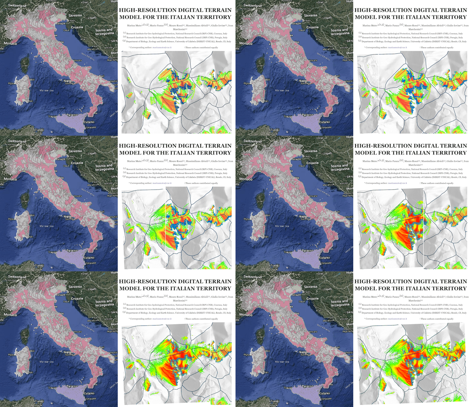
Italy releases updated 5 m national digital terrain model [link]
Version 1.3 of Italy’s HR-DTM-5m includes corrections to the national elevation mosaic and a new GeoPackage showing the source and reference period of the elevation data. The model combines airborne LiDAR surveys, covering around 60% of the country, with the 10 m TINITALY terrain model elsewhere.
IPERLITE hyperspectral data now available through Terrascope [link]
Belgium’s IPERLITE mission has entered its operational phase, with open Level-1C and Level-2A hyperspectral products available through Terrascope. Its CSIMBA instrument provides observations at 20 m resolution across 133 reported spectral bands, and registered users can request new acquisitions over areas of interest.
Google releases GEM-15 near-global elevation dataset and preprint [link]
GEM-15 provides six elevation layers at 15 m resolution, derived from sub-metre optical stereo imagery acquired through 2024. Alongside the digital surface and terrain models, the dataset includes elevation percentiles and within-cell height variability, with coverage and access provided through Google Earth Engine and Cloud Storage.

Snapshots
MTG-I2 shares its first 2.5-minute rapid-scan imagery [link]
ESA has released a 45-hour sequence of MTG-I2 images taken every 2.5 minutes over Europe and North Africa. The animation shows fog over central Europe, developing storms over the Mediterranean and a wildfire smoke plume over Portugal. The satellite is expected to enter operational service in the second quarter of 2027.
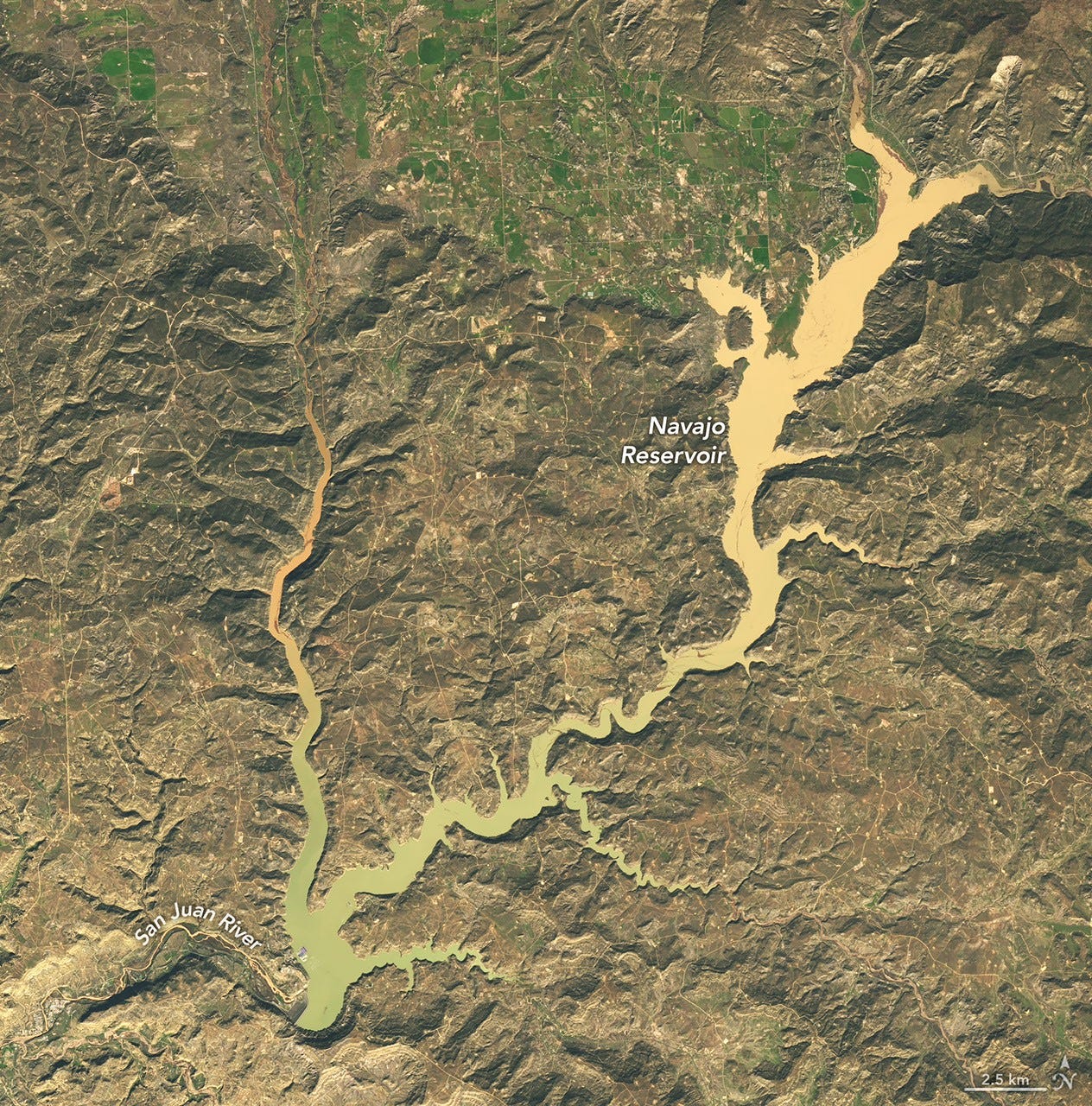
Water surges into Navajo Reservoir [link]
Two Landsat 9 images, acquired on 20 September and 7 November, show the rise in Navajo Reservoir following heavy rain across the US Southwest. Water levels increased by nearly 18 metres between the two observations, reaching their highest level since August 2019.
Interesting reads
Decomposing Earth Embeddings with Sparse Autoencoders [link]
Researchers apply sparse autoencoders to AlphaEarth and Tessera embeddings to examine what their learned features represent. They find that sparse features tend to align with fewer reference concepts than the original embedding dimensions, and explore their use for land-cover interpretation and detecting unusual observations.
Climate
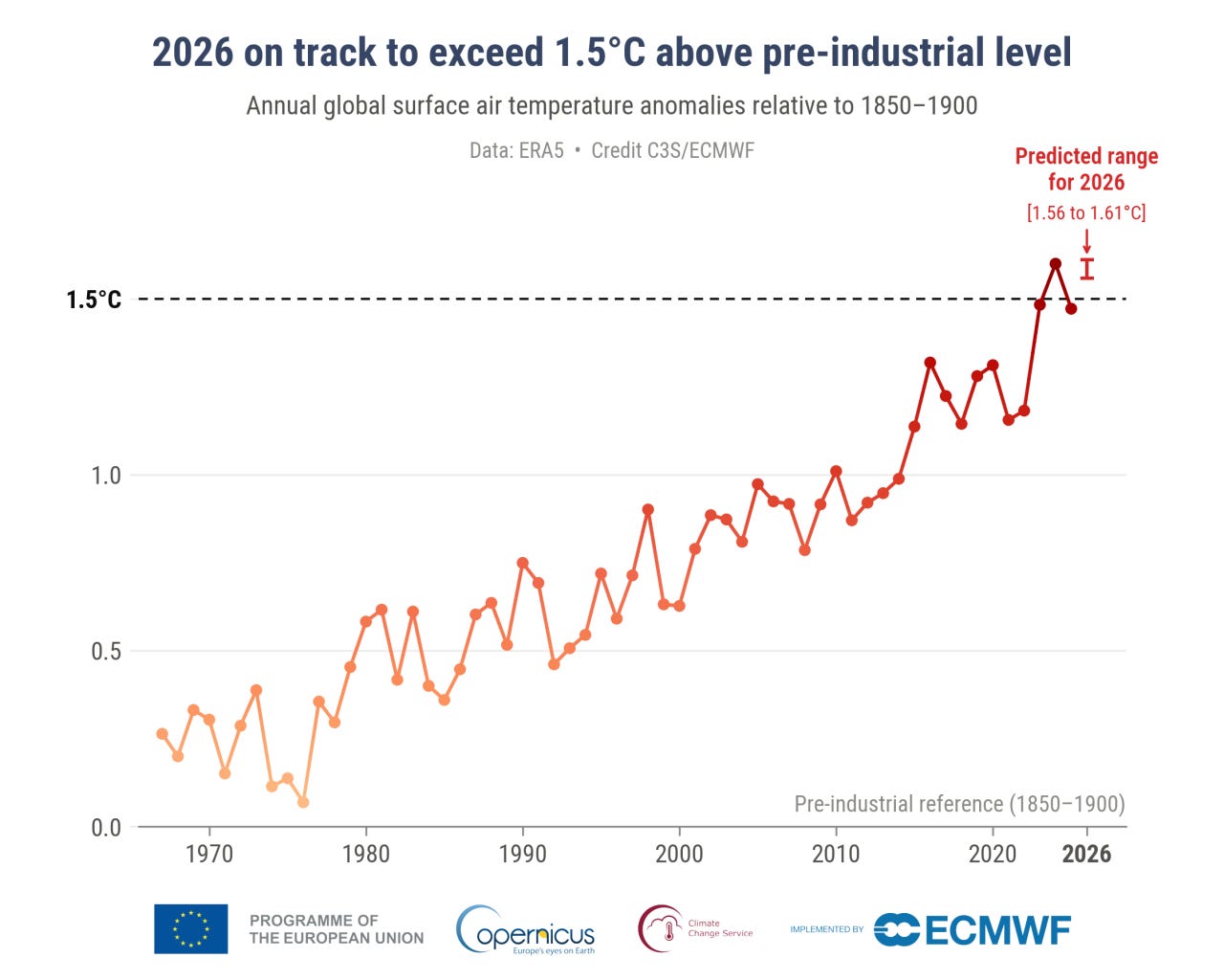
Copernicus reports the warmest October on record [link]
October 2026 was the warmest October on record, according to ERA5, at 0.90°C above the 1991-2020 average and 1.75°C above pre-industrial levels. Copernicus also expects 2026 to become the second calendar year, after 2024, with a global average temperature more than 1.5°C above the pre-industrial baseline.
Climate change and El Niño intensified Indonesia’s 2026 fire weather [link]
A World Weather Attribution study examined the hot, dry conditions behind Indonesia’s severe August-October fire season. The researchers estimate that human-caused warming made short-term extreme fire-weather conditions about three times more likely, while El Niño increased their likelihood by roughly five times.
Upcoming Events
EOPF Explorer webinar to cover Sentinel-1/2 fusion using Zarr [link]
The third EOPF Explorer webinar takes place on 25 November, covering cloud-native Sentinel-1 and Sentinel-2 data fusion using titiler-openeo. The session will also present benchmarks comparing EOPF Zarr with Cloud Optimized GeoTIFFs, including the effects of chunking and multiscale pyramids on performance.
The Morning Backscatter
The Spectral Reflectance Newsletter is not always a quick read, so I started The Morning Backscatter as a shorter and lighter companion for the morning: one news item, one useful link, one visual, and one funny-ish item from the EO world.
There is no mailing list; new issues are published via GitHub Releases, and instructions on how to follow along are available in the repository README.
The Morning Backscatter: https://morningbackscatter.space/
GitHub repo: https://github.com/xen0f0n/morning-backscatter