
Level-2 News
NASA and USDA sign an EO and agricultural data cooperation agreement [link]
The memorandum covers possible uses of satellite data in crop acreage and yield estimation, drought assessment and geospatial analytics. NASA and USDA plan to explore how their datasets and methods could be combined for agricultural decisions.
CRISTAL deploys its solar array in assembly testing [link]
The solar wing completed a deployment test as the ice-altimetry spacecraft moves through assembly. ESA is targeting a launch in late 2027 or early 2028.
MetOp-SG-B1 reaches Europe’s Spaceport [link]
The polar weather spacecraft has arrived in French Guiana for its launch campaign. Its instruments include a microwave imager, radio-occultation sounder and scatterometer for observing precipitation, atmospheric profiles and ocean winds.
ICEYE deploys four SAR satellites, including two for Portugal [link]
Two of the four spacecraft launched on Bandwagon-5 are dedicated to Portugal’s Atlantic Constellation.
Planet launches Pelican-12 with AI and data-relay tests [link]
The spacecraft carries an onboard Jetson processor and a prototype relay package intended to test links through SES’s O3b mPOWER system. These experiments target faster processing and delivery of high-resolution imagery.
Planet secures NASA evaluation of Tanager hyperspectral data [link]
NASA’s Commercial Smallsat Data Acquisition programme will assess more than 250,000 square kilometres of Level 1C and Level 2A imagery.
EarthDaily wins $3m NASA Landsat interoperability task order [link]
NASA and USGS will test the data’s calibration, geometry and harmonisation against Landsat requirements. The $3 million task order also examines whether standardised commercial observations can support machine-learning workflows.
My read: HLS is a good example of how much work goes into making observations from different sensors comparable and interoperable. I’d like to see EarthDaily evaluated with the same rigour, particularly around calibration, geometric accuracy, spectral differences, consistency over time and integration into existing processing workflows. More frequent observations would be valuable, provided they can reliably complement the decades-long Landsat record.
BlackSky expands Gen-3 Assured defence imagery contract [link]
An international defence partner doubled its subscription to a seven-figure Gen-3 Assured agreement in under six months.
My read: In contested regions, assured collection capacity can matter as much as resolution.
ICEYE and OroraTech combine SAR and thermal wildfire intelligence [link]
The planned service combines thermal detection and fire-front tracking with radar imaging through smoke and clouds. The partners also propose post-fire assessment of structures and infrastructure.
Pixxel establishes U.S. federal subsidiary [link]
The new unit is intended to serve United States agencies with hyperspectral data, mission systems and geospatial intelligence. It gives the company a dedicated federal contracting presence.
Scanway and Pixxel expand optical payload partnership [link]
The memorandum extends cooperation on advanced optical payloads for the Indian company’s satellite plans. It links Polish instrument manufacturing with a growing commercial hyperspectral programme.
Satellogic and HEO sign three-year non-Earth imaging agreement [link]
The three-year arrangement gives HEO access to Satellogic’s constellation through 2029. It includes a seven-figure annual minimum commitment for imaging other spacecraft.
My read: Earth-imaging constellations are finding another commercial market in observing other spacecraft. I could also see this being used to assess satellites ahead of in-orbit servicing missions.
Argotec raises €50m to expand smallsat production [link]
Investor NUO subscribed a €50 million capital increase to support satellite production and downstream data services. Argotec’s programmes include the European IRIDE HEO constellation.
PlanetiQ launches GNOMES-11 radio-occultation satellite [link]
The spacecraft reached orbit on the Bandwagon-5 mission, following GNOMES-10 earlier in October. Its radio-occultation observations are intended for atmospheric and ionospheric profiling.
Tomorrow.io launches microwave sounders S14 and S15 [link]
The pair reached orbit on Bandwagon-5 after S12 and S13 launched on 1 October. Their microwave sounding measurements are intended to feed the company’s weather observation network.
My read: These two launches reflect the growing role of commercial satellites in weather forecasting. NOAA and EUMETSAT already purchase radio-occultation data for operational use, while commercial microwave sounders are still being evaluated. With public missions ageing, I expect weather services to rely increasingly on commercial observations.
FireSat starts independent calibration and validation campaign [link]
The campaign plans comparisons against instrumented prescribed burns, airborne thermal imaging and civil satellite observations. Its first validation events are scheduled for 2027.
Developer's Orbit
GeoRacoon: parallel raster processing and the RAM–runtime trade-off [link]
Built on Rasterio and GDAL, GeoRacoon processes GeoTIFFs in blocks for parallel filtering and multiple linear regression, with configurable block sizes and worker counts. Its benchmark walkthrough uses a synthetic 20,000 × 20,000-pixel raster to compare runtime and peak memory use against full-raster processing. Smaller blocks and fewer workers can reduce memory use, at the cost of additional overhead or longer runtimes, while adding workers only helps when there are enough blocks to keep them busy.
Related:
GeoRacoon: A Python package for scalable, parallelized geospatial raster analysis [link]
The coon-way: Fragmented raster computations [link]
STAC Embeddings extension reaches 1.0.0 proposal [link]
The proposal describes how vector embeddings and their provenance can be represented in STAC metadata. A versioned schema could make global embedding collections easier to discover.
USGS shifts Landsat archive notifications from RSS to SNS [link]
Collection 2 inventory updates are being offered through Simple Notification Service topics.
cubo 2026.10.1 supports coregistered multi-collection cubes [link]
One call can place Sentinel-1 and Sentinel-2 collections from different STAC services on a common pixel grid. The result can be returned as an xarray DataTree, Dataset or DataArray, including Earth Engine inputs.
Agentic AI in EO
OpenEarthAgent - A Unified Framework for Tool-Augmented Geospatial Agents [link]
The repository now offers a demo and revised evaluation results for its tool-using geospatial agent.
EUMETSAT publishes five agent skills for satellite-data workflows [link]
Five version-controlled skill packages cover satellite product access, Data Tailor, European Weather Cloud, Firecube and weather-feature queries. They tell compatible coding agents how to use the respective EUMETSAT tools.
→ GitHub repo [link]
Agents with Constraints [link]
The team at Development Seed argues for restricting tools, output formats and model scope when building scientific agents.
Portolan publishes agent-skill tutorial for open geospatial catalogues [link]
The guide uses a bootstrap agent skill to convert East Hampton’s Esri data into a catalogue published on Source Cooperative.
Data
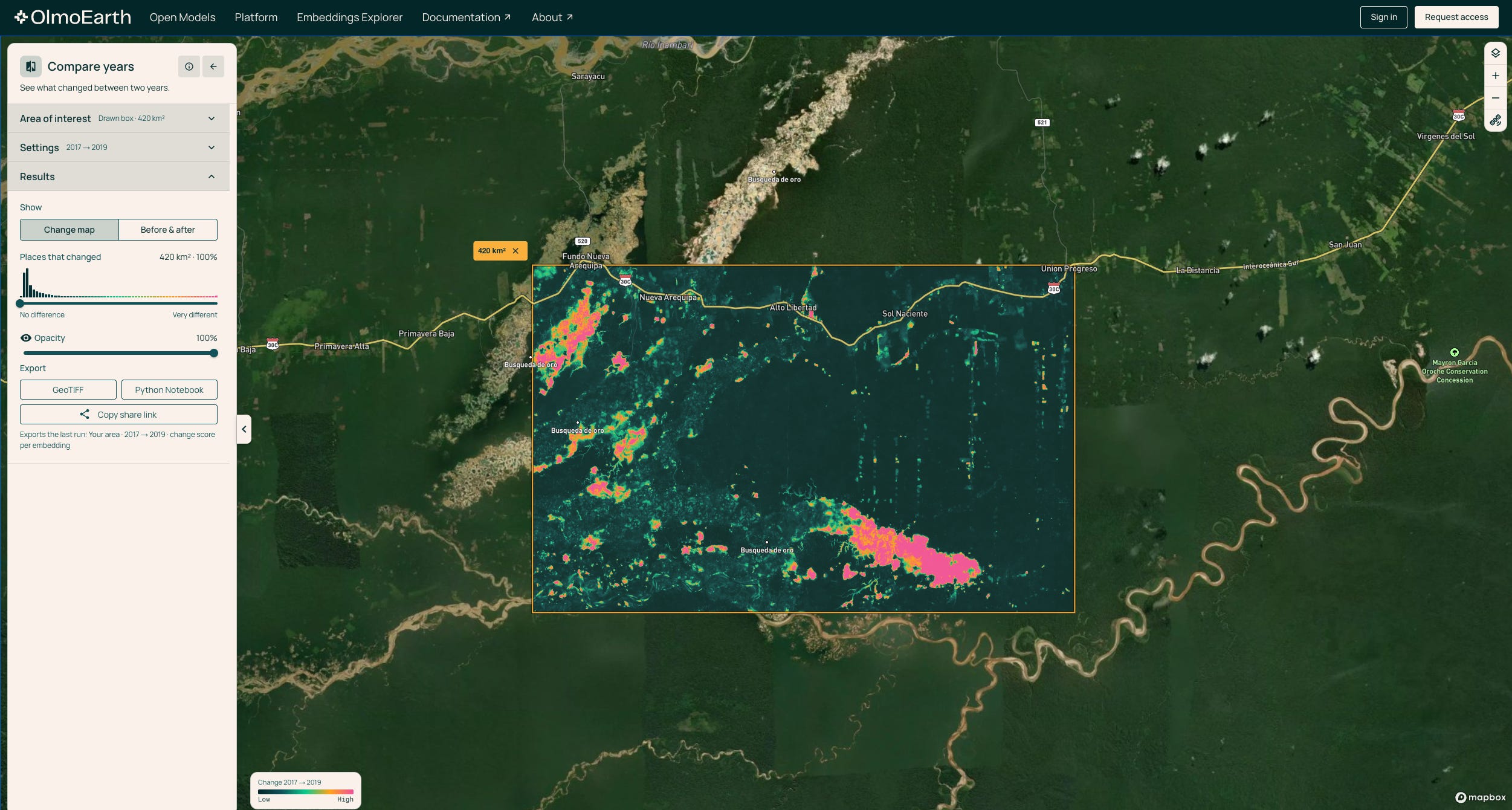
Ai2 releases OlmoEarth v1.3 global annual embeddings and explorer [link]
The release includes model weights, annual 10-m embeddings from radar and optical imagery, a technical report and a browser explorer. The 128-dimensional representation ranked first in 20 of 27 evaluations against AlphaEarth Foundations and Tessera v2, according to Ai2.
CDSE rolls back Sentinel-1 processor after quality issues [link]
The service returned from processor version 4.1.1 to 4.0.3 after quality disclaimers on recent radar products. Version 4.1.1 had entered production on 22 October.
Very-high-resolution Europe 2024 mosaic opens for authorised download [link]
Authorised users can now retrieve the 2024 continental mosaic through OData and S3.
Suomi NPP VIIRS discontinuation affects TROPOMI L2_NP production [link]
The L2_NP product line is expected to stop for acquisitions after 2 November because its Suomi NPP VIIRS input is ending.
Earth Index v7 changes embeddings and imagery composites [link]
The new vectors return to the SSL4EO model and use GeoParquet 1.1 with embedded STAC metadata. The switch from Softcon back to SSL4EO also makes the new vectors incompatible with the previous release.
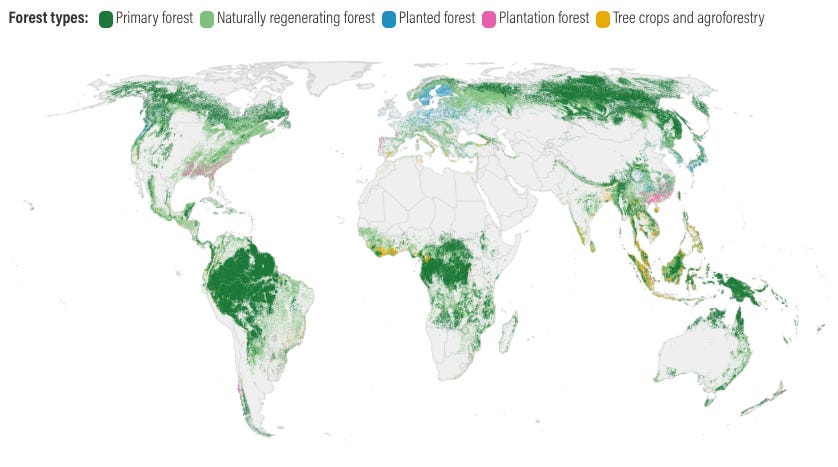
Global Nature Watch adds 10-m global forest typology [link]
The 2020 map distinguishes primary, naturally regenerating, planted and plantation forests, tree crops and agroforestry, and other land at 10-m resolution.
Related:
Global forest typology at 10-meter resolution for forest and land-use monitoring [link]
OroraTech extends ESA call for afternoon thermal data [link]
Eligible researchers can request 200-m land-surface-temperature products from FOREST-2 and the eight-satellite OTC-P1 constellation.

Snapshots
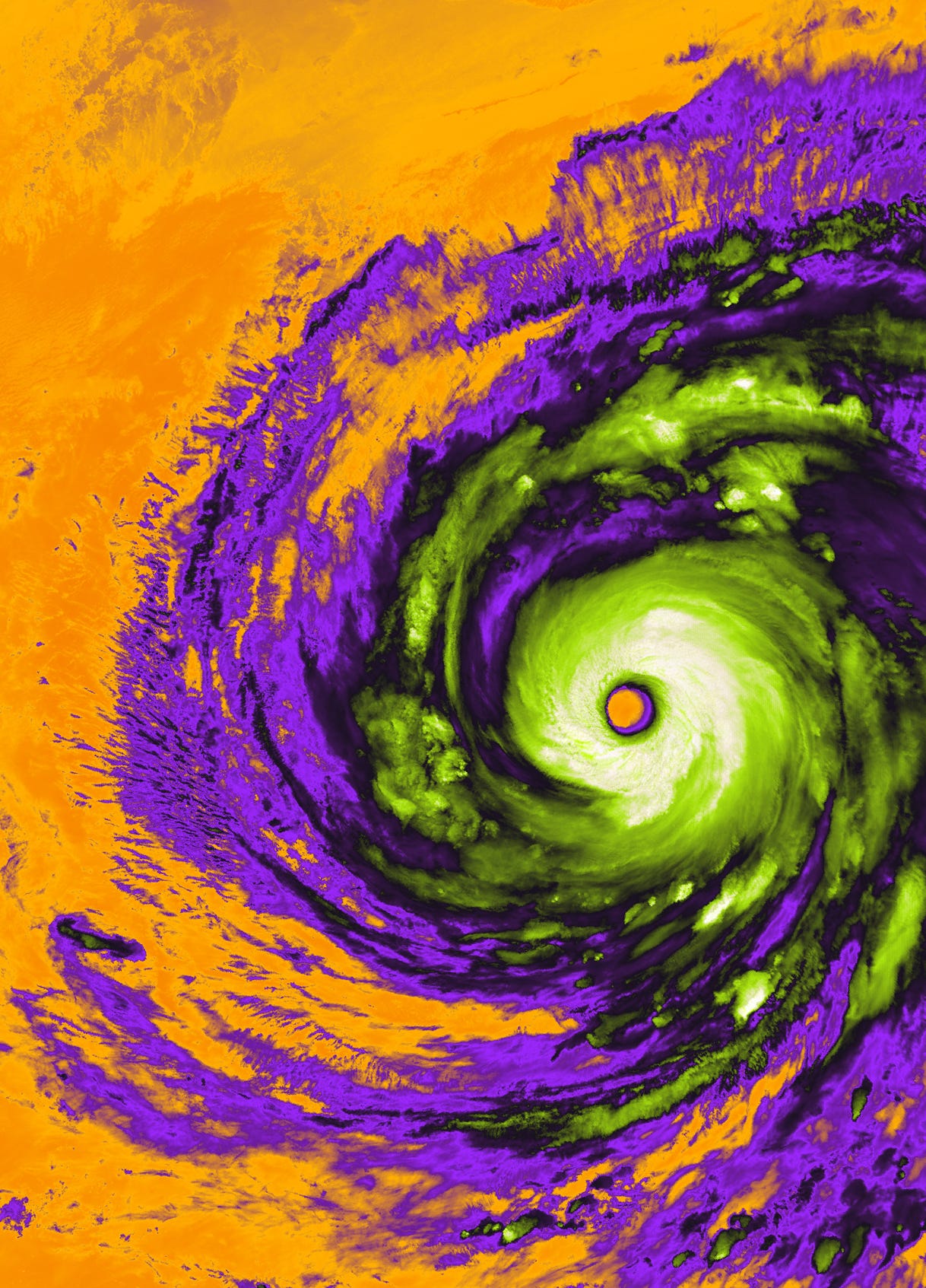
Earth from Space: Champi’s eerie eye [link]
Captured by Copernicus Sentinel-3 on 21 October, this false-colour thermal image shows Super Typhoon Champi off Taiwan and the Philippines. Its eye spans approximately 50 km, while the colours represent brightness temperatures, reaching as low as -70°C over the coldest clouds.
Interesting reads
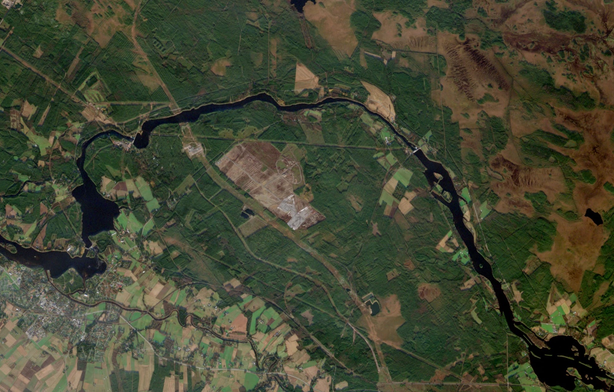
Satellite analysis tracks forest clearing at Google’s Finnish data-centre sites [link]
Google’s planned data centres in Muhos and Kajaani drew scrutiny in September after the Finnish Association for Nature Conservation raised concerns about clearing before environmental impact assessments were complete. Vertical52, collaborating with Otter News, subsequently used Sentinel-2 NDVI changes to estimate at least 647 hectares of vegetation loss across the two sites. Finnish police have since opened a criminal investigation into suspected environmental damage at Muhos, including concerns about drainage and water management.
→ Before and after Sentinel-2 acquisitions; Copernicus Browser [link]
New FireSat paper lays out wildfire science strategy [link]
The report draws on three international workshops to set a 2026-2030 research agenda. It prioritises independent validation, uncertainty, emissions, health and ecosystem applications.
→ Paper [link]
From Spectral Reflectance
What Does an Agent Actually Add to Earth Observation? [link]
My thoughts on the Agentic AI for EO workshop in Berlin. I look at how agents compare with existing EO workflows, what we should actually be benchmarking, and where the costs and difficulties of operational integration lie.
Climate
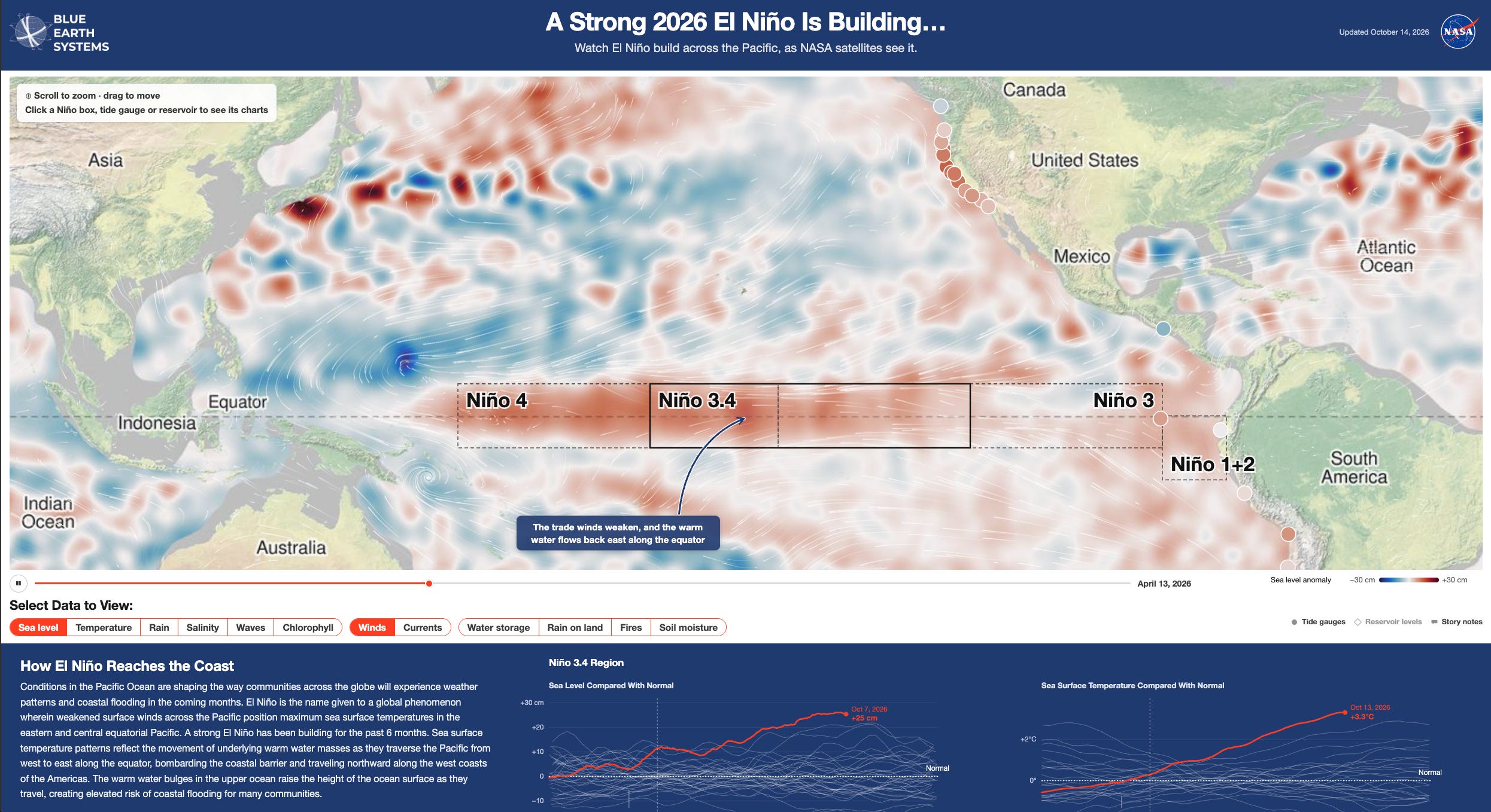
Blue Earth Systems unveils prototype multi-mission El Niño dashboard [link]
The early dashboard brings together sea level, water storage, rain, soil moisture and ocean observations from several NASA missions.
New Guinea fires and haze seen during El Niño drought [link]
Satellite views show widespread burn scars and smoke across Indonesian Papua during September and October.
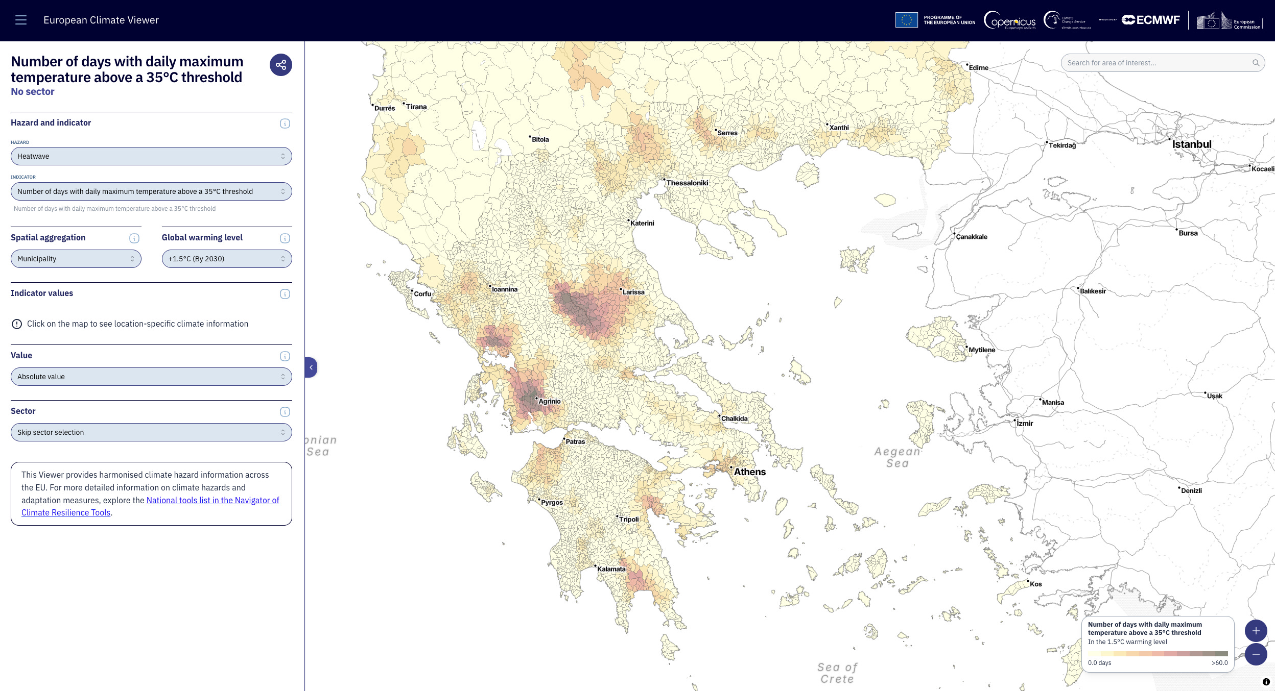
European Climate Viewer opens harmonised hazard comparisons [link]
The free map compares hazards across Europe under reference warming levels using CERRA and EURO-CORDEX inputs. It spans heat, drought, wildfire, precipitation, cold and sea-level indicators.
Competitions
ESA Φ-lab opens Sahel cropland-abandonment challenge [link]
Teams are invited to map rainfed fields abandoned amid conflict in the Sahel using Earth observation and AI. Applications are due on 15 January 2027.
Call For Papers
EGU27 opens geoscience abstracts [link]
The Vienna and hybrid meeting is accepting abstracts for April 2027. The general submission deadline is 12 January 2027.
Learning
CNG London 2026 releases session recordings [link]
The newly available videos cover Earth embeddings, Zarr chunking, compression, drought mapping and imagery for disaster response. The sessions were recorded at the June London meeting.
My post-event article is here [link]
The Morning Backscatter
The Spectral Reflectance Newsletter is not always a quick read, so I started The Morning Backscatter as a shorter and lighter companion for the morning: one news item, one useful link, one visual, and one funny-ish item from the EO world.
There is no mailing list; new issues are published via GitHub Releases, and instructions on how to follow along are available in the repository README.
The Morning Backscatter: https://morningbackscatter.space/
GitHub repo: https://github.com/xen0f0n/morning-backscatter