
Four decades of watching our weather from space
"2026 marks 40 years since EUMETSAT’s founding convention entered into force, establishing Europe’s weather satellite agency. From the original Meteosat satellites to today’s Meteosat Third Generation, Metop Second Generation and the Copernicus Sentinel missions, EUMETSAT has delivered continuous satellite data supporting weather forecasting, and environmental and climate monitoring across Europe and beyond."
Level-2 News
Time to say goodbye to Sentinel-1A [link]
ESA has retired Sentinel-1A after 12 years of C-band SAR operations, with Sentinel-1C and Sentinel-1D now taking over the Copernicus radar mission and maintaining continuity for all-weather Earth Observation.
One detail I liked from Nuno Miranda: Sentinel-1A also carried cameras used to verify deployment of its solar arrays and SAR antenna, giving this radar mission a very brief optical side quest during commissioning. [link]
ESA Awards Initial €700M Contract for Next-Gen Sentinel-1 Satellites [link]
ESA has awarded Thales Alenia Space an initial €700 million contract to build two Sentinel-1 Next Generation satellites, with Airbus Defence and Space providing the C-band SAR instruments for a mission designed to maintain Copernicus radar-imaging continuity while improving coverage and resolution.
ICEYE’s Valuation Soars to 10 Billion Euro With New Raise [link]
ICEYE has raised a €450 million Series F round led by General Atlantic, alongside a secondary placement bringing the total transaction to €1 billion, lifting the Finnish SAR satellite company’s valuation to about €10 billion as demand grows for sovereign space-based intelligence.
Related:
Europe’s sovereign-intelligence boom is just beginning, and it needs more companies like ICEYE [link]
A SatNews commentary uses ICEYE’s rapid growth as a signal that Europe’s demand for sovereign space-based intelligence is only beginning, arguing that the region will need more companies able to build, launch, and operate defence-relevant satellite systems at speed.
Vantor and Rheinmetall Plan Joint Venture for Sovereign Space in Germany [link]
Vantor and Rheinmetall have signed an MoU to form a Germany-based joint venture focused on sovereign spatial intelligence, combining Vantor’s satellite-derived 2D and 3D intelligence capabilities with Rheinmetall’s defence and command-and-control systems for Germany and other European partners.
Muon Space Unveils Condor-Ultra, Starship-Class Spacecraft Platform Built for Scale [link]
Muon Space has unveiled Condor-Ultra, a larger spacecraft platform designed for mass-deployed constellations on Starship and other launchers, with 20 kW power, more than 18 m² of nadir payload area, Starlink connectivity, and support for communications, sensing, and orbital compute missions.
SOMA Satellite Factory: Planet Labs Expands San Francisco HQ to Supercharge Production Pipeline [link]
Planet Labs is expanding its SoMa headquarters at 645 Harrison Street to increase satellite manufacturing capacity, with reported order growth driven largely by defence and intelligence demand.
BAE Systems to build Vantor Vantage satellite buses [link]
BAE Systems has signed an agreement to build the satellite buses for Vantor’s next-generation Vantage imaging satellites, supporting a planned 20 cm-class commercial imaging system for national defence and intelligence customers.
KSAT to Lead European Pollution-Focused Poseidon EO Mission [link]
KSAT will lead the Horizon Europe-funded POSEIDON project, which will use optical and radar satellite data to improve detection of oil spills, ship-source pollution, and other pollutants in maritime areas under growing pressure from vessel traffic.
NRO Awards BlackSky Multi-Million Dollar Modification to Accelerate AROS Development [link]
The National Reconnaissance Office has awarded BlackSky a contract modification to accelerate development of AROS, its planned multi-spectral broad-area imaging satellites, with a flight-ready large-area mapping spacecraft and foundation data collection system targeted for 2028.
Developer's Orbit
ECMWF launches earthkit 1.0 for next-generation weather and climate workflows [link]
ECMWF has launched earthkit 1.0, an open-source Python ecosystem for accessing, analysing, processing, and visualising weather and climate data through interoperable packages that can be used separately or together in operational and research workflows.
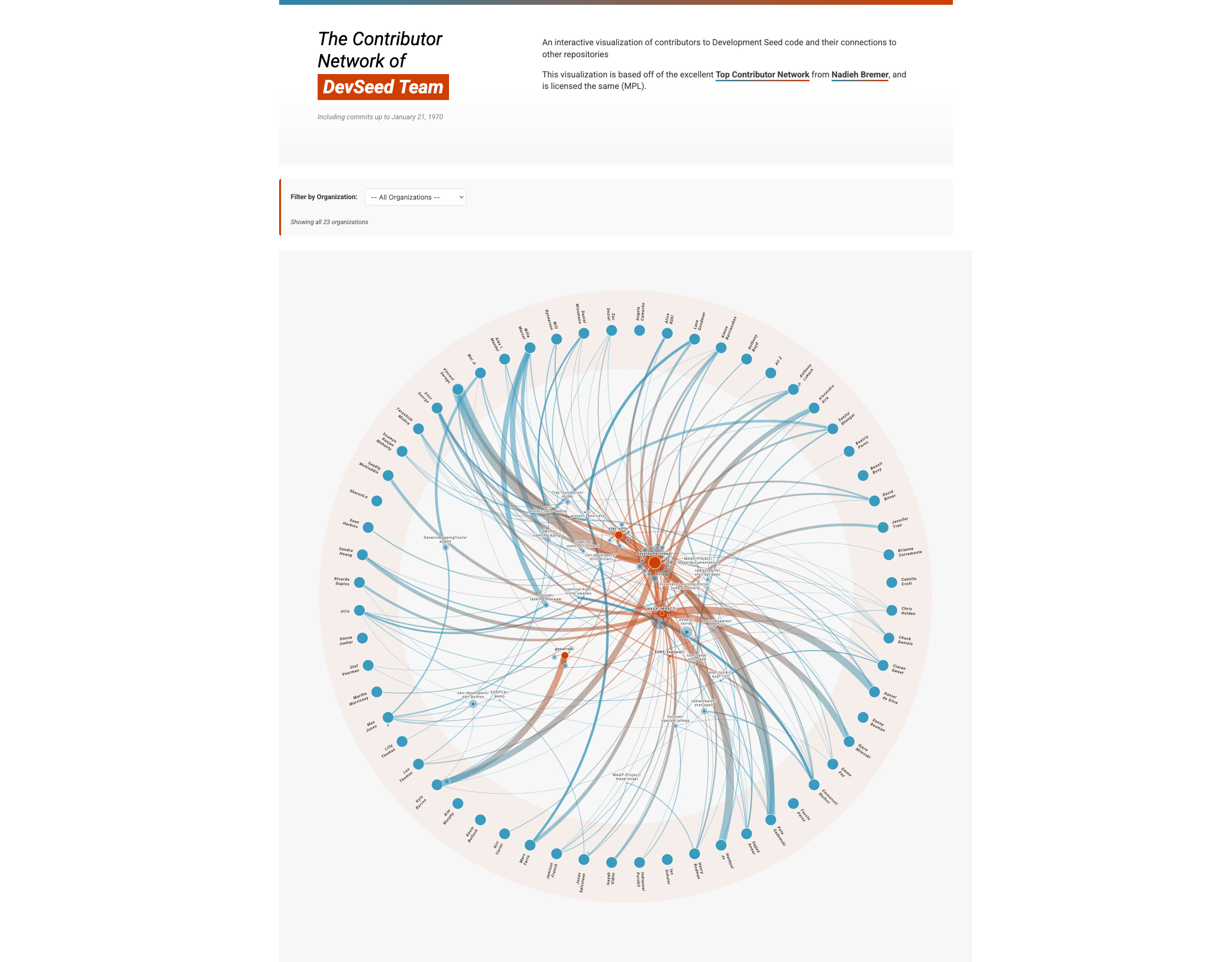
The Shape of Our Open Source [link]
Development Seed’s Contributor Network maps the repos its team contributes to, inside and outside the organisation, and shows open-source work as a network of people, projects, and maintenance.
Development Seed Contributor Network [link]
OLMoEarth v1.2 released [link]
Ai2 has released OLMoEarth v1.2, a more efficient family of Earth observation foundation models that keeps overall performance close to the original release while cutting training cost by about 3×, reducing Sentinel-2 inference compute by 2.9×, and removing striping artefacts in the embeddings.
Tech report [link]
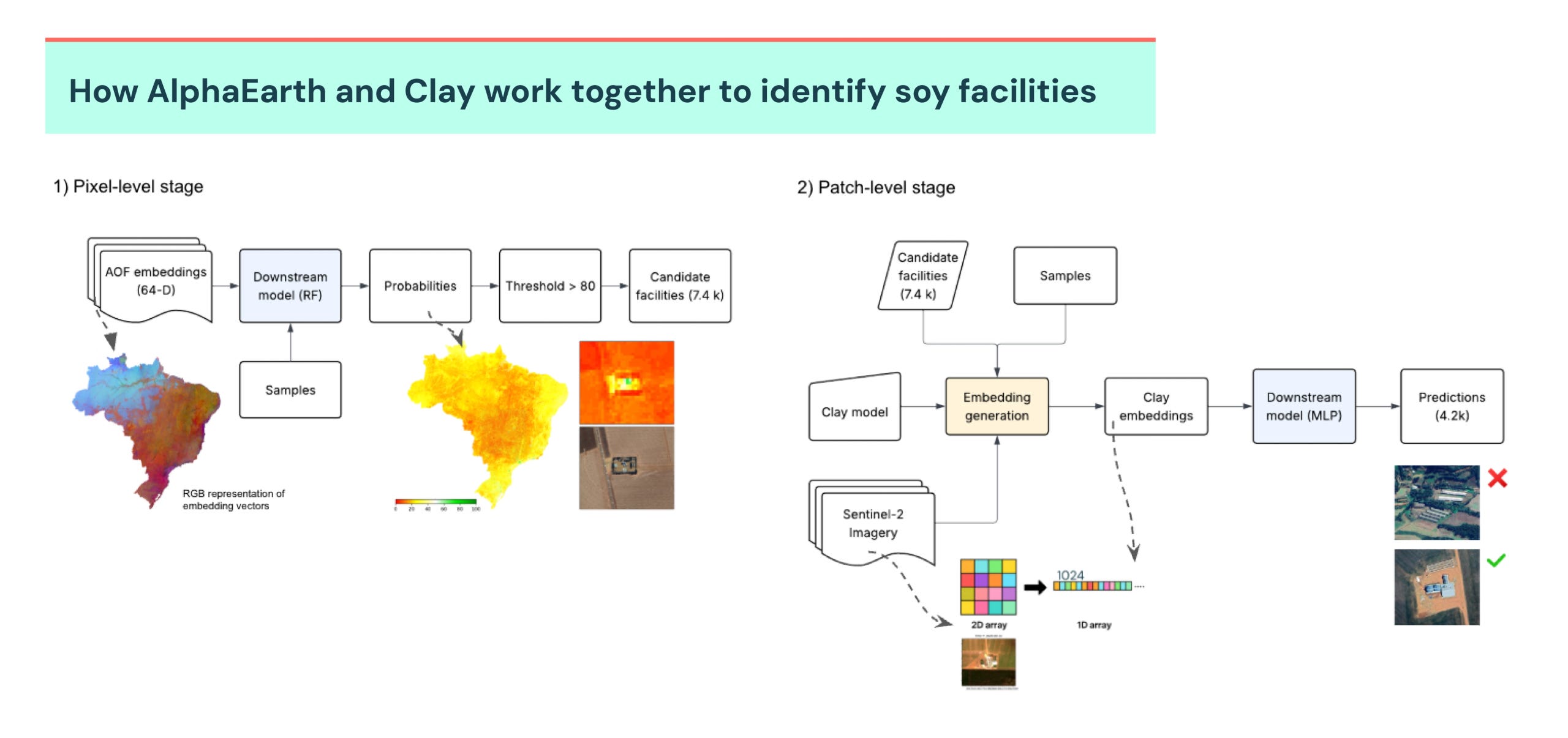
Mapping soy facilities in Brazil with EO foundation models [link]
Trase and Ode Partners used AlphaEarth and Clay embeddings to identify soy processing and storage facilities across Brazil, starting with 321 ground-truth points and narrowing the search from the whole country to 12,000 candidate locations. The workflow uses AlphaEarth to scan for likely facilities, Clay to reduce false positives with surrounding spatial context, and official storage records plus MapBiomas soybean areas for final cross-checks.
Searching heterogeneous Zarr stores with DataFusion [link]
Sean Harkins shares a Development Seed prototype for querying STAC-style metadata directly inside Zarr, using Apache DataFusion to search across EO arrays that differ in data type, codec, chunking, or CRS without forcing them into one neat temporal datacube.
Data
Venezuela Earthquakes, 2026-06-24: Planet crisis response imagery related to the earthquakes in Venezuela [link]
Planet has shared imagery for the 24 June 2026 Venezuela earthquake through Source Cooperative, including pre-event basemaps and 50 cm SkySat/Pelican post-event scenes for areas such as Caracas, La Guaira, Catia La Mar, Puerto Cabello, Valencia, Ocumare de la Costa, and Yumare. The dataset is available as a STAC/Portolan catalog, with true-colour, analytic, and quality-mask COGs that can be used to inspect the affected areas and compare conditions before and after the earthquake.
Related:
AI-powered damage assessment data on HDX [link]
Microsoft’s AI for Good Lab has published damage-assessment data on HDX, using 25–26 June 2026 satellite imagery to map earthquake-affected buildings in Catia La Mar, Caraballeda, La Guaira, and East Catia La Mar, Venezuela. [link]Vantor opens imagery for the Venezuela earthquake response [link]
Vantor has activated its Open Data Program for Venezuela, providing free high-resolution before-and-after imagery to frontline organisations and the open-source mapping community, with new imagery being added as it becomes available.
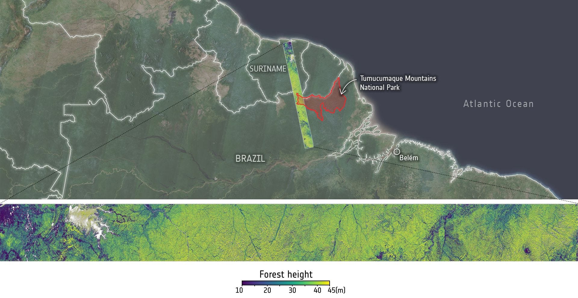
Biomass Level-2 product release schedule [link]
ESA has published the Biomass Level-2 release schedule, with Forest Height and Ground Notching products due on 30 June 2026, followed by Forest Disturbance, Forest Biomass, and Map of Forest Biomass products through 2027.
Annual NLCD Collection 1.2 Now Available [link]
USGS has updated the Annual NLCD collection with 2025 data, adding another year to its 30 m Landsat-based record of land cover and surface change across the conterminous United States.
Google Expands Heat Resilience Data to 50+ Cities [link]
Google Research has expanded its Heat Resilience dataset to 50+ cities, using fused Sentinel-2 and high-resolution commercial imagery to provide building-level rooftop albedo data through a public Earth Engine app for cool-roof planning.
Heat Resilience Earth Engine App [link]
Urban Atlas 2021 product update is now available [link]
The Copernicus Land Monitoring Service (CLMS) has released the Urban Atlas 2021 update, adding improved urban land-cover and land-use data for Europe’s Functional Urban Areas, with a new 3-year update cycle, semi-automatic change detection, and combined use of VHR imagery and Sentinel-2 data.
ESA Lakes CCI lake products v3.0 [link]
ESA Lakes CCI version 3.0 provides global satellite-derived lake products from 1992 to 2023 for more than 2,000 inland water bodies, covering lake water level, extent, surface water temperature, ice cover, water-leaving reflectance, ice thickness, and storage change. The new release adds longer time series, improved spatial coverage, new variables, and updated algorithms for some products.
New EarthCARE Quick Guides available [link]
ESA has added EarthCARE quick guides to the product handbook, helping users find the right data product for specific atmospheric and surface retrieval topics.
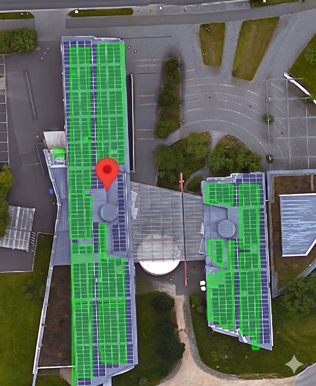
Google Maps adds detected solar arrays [link]
Google Maps Platform’s Solar API now includes a Detected Arrays feature, letting energy companies check whether a building already has solar panels and use that hyper-local view of deployment for grid planning, demand response, and virtual power plant programmes.

Snapshots
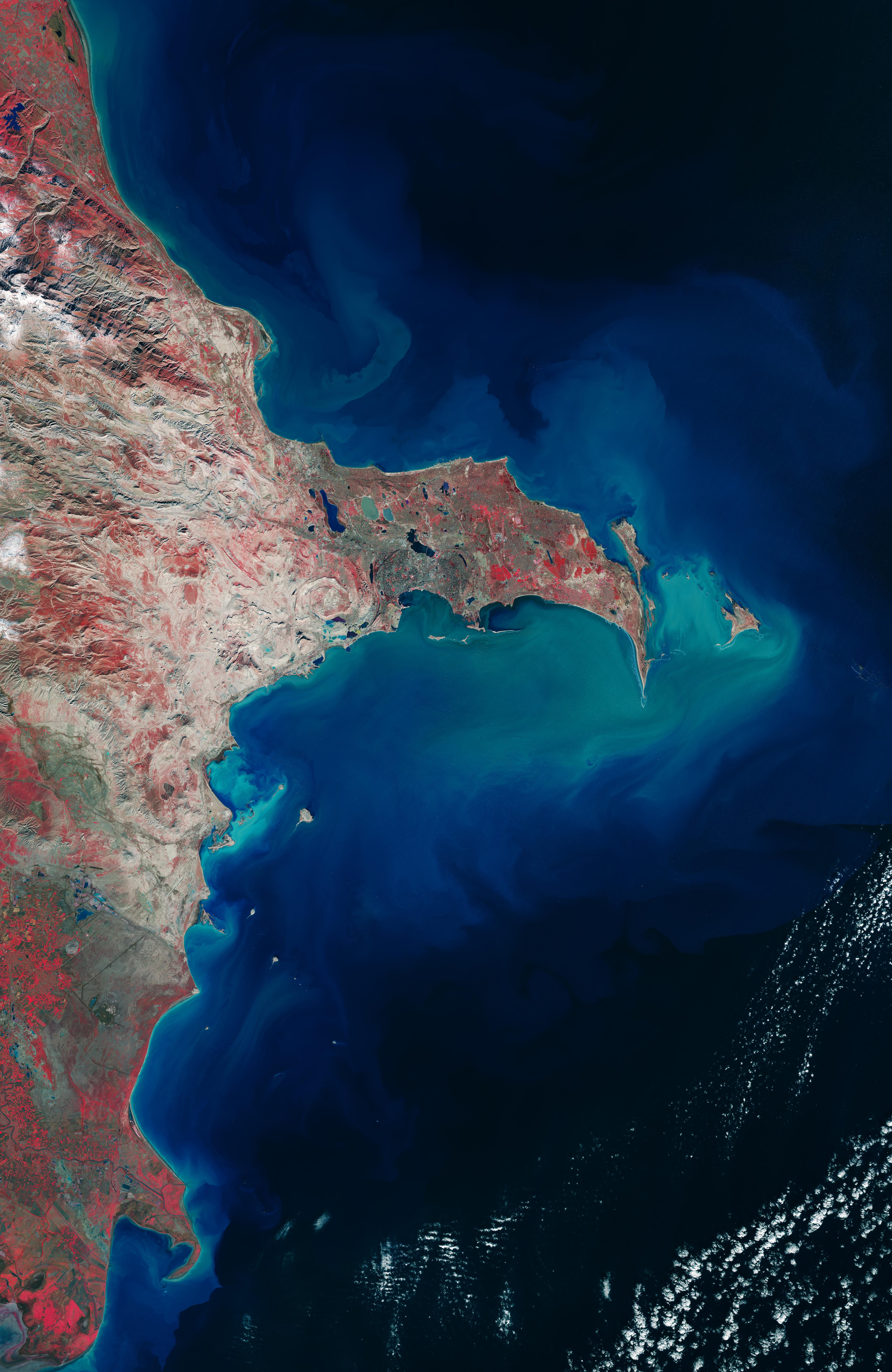
Earth from Space: Baku, Azerbaijan [link]
ESA uses Copernicus Sentinel-2 data from January 2026 to show Baku in grey on the southern side of the Absheron Peninsula, which extends about 60 km from Azerbaijan’s coast into the Caspian Sea and helps protect the city from strong winds. The false-colour image uses Sentinel-2’s near-infrared channel, making dense vegetation appear bright red, while the Caspian Sea appears dark blue or black and turbid coastal waters show up in cyan or light blue.
Interesting read
NASA-Funded Study Shows Wildfire Smoke’s Hidden Ozone Toll [link]
A NASA-funded study finds that wildfire pollution has worsened ground-level ozone across much of the contiguous U.S., offsetting years of air-quality gains and exposing an estimated 43 million additional people to unhealthy ozone conditions from 2022 to 2024. The visualisation shows smoke from Canada’s 2023 wildfires spreading across North America, with tan to deep red colours showing smoke intensity estimated from black carbon in NASA’s GEOS-FP model.
Four decades of global mangrove change [link]
A Science paper and Earth Engine app map annual global mangrove extent and canopy cover at 30 m from 1984 to 2023, showing slower losses after 2000 and a global net gain since around 2010. That does not mean mangroves are recovering everywhere, but the dataset gives a clearer view of where they are disappearing, returning, or growing denser.
Paper: Unexpected expansion and regrowth in Earth’s mangrove forests over the past four decades [link]
GEE App: Continuous Global Mangrove Dynamics [link]
Mangrove forests are healing after decades of human destruction [link]
The World’s Mangrove Forests Show Net Gain Globally [link]
Permafrost slumps are accelerating in West Siberia [link]
A new study using historical and modern satellite imagery finds a 23-fold increase in retrogressive thaw slumps across key study sites in the West Siberian Arctic since the 1960s. The work links the rise mainly to Arctic winter warming, with added risks for pipelines, roads, railways, gas infrastructure, and Indigenous communities engaged in reindeer herding and seasonal migration.
A few findings:
The study uses a field-verified inventory of 6,168 retrogressive thaw slumps across the Yamal and Gydan peninsulas.
Across key study sites, thaw slump numbers increased 23-fold from 1964 to 2024, while initiation rates rose 26-fold.
Summer maximum precipitation appears to be the strongest short-term trigger, but winter warming is identified as the dominant long-term driver.
The highest infrastructure exposure is in Yamal, where pipelines, roads, railways, electrical lines, and gas-field infrastructure overlap with current or potential thaw slump areas.
Paper: Rapid increase in West Siberia’s retrogressive thaw slumps since 1964 associated with Arctic winter warming [link]
NASA uses Overture building footprints for Venezuela earthquake damage mapping [link]
After the 24 June 2026 Venezuela earthquakes, NASA used Sentinel-1 SAR data and Overture Maps building footprints to quickly map likely damaged structures.
Marine Heatwaves and Medicanes [link]
ESA’s Edukeo story looks at how marine heatwaves are affecting phytoplankton in the Mediterranean Sea, and how EO research from CAREHeat and MEDICANES is helping connect ocean warming, ecosystem change, and the conditions behind powerful Mediterranean storms.
Notes from CNG London
Two write-ups from the first Cloud-Native Geospatial Forum gathering outside the U.S.: Anil Madhavapeddy’s notes cover the talks, demos, and recurring technical themes from the day, while mine take a broader look at the cloud-native geospatial community and where things seem to be heading.
A scorching CNG London during Climate Action Week by Anil Madhavapeddy [link]
CNG London: People Who Fight With Data for a Living [link]
Climate — El Niño
The Return of El Niño? What a Potential 2026 Event Could Mean for Wildfires Around the World [link]
The State of Wildfires Project explains why a possible moderate-to-strong El Niño in 2026 could raise fire concerns in places such as the Amazon, Canada, and Indonesia, depending on how it shapes drought, heat, and vegetation growth. The authors also note that seasonal forecasts can help with preparation, but they are still scenarios, not predictions.
From Spectral Reflectance
The Morning Backscatter
The Spectral Reflectance Newsletter is not always a quick read, so I started The Morning Backscatter as a shorter and lighter companion for the morning: one news item, one useful link, one visual, and one funny-ish item from the EO world.
There is no mailing list; new issues are published via GitHub Releases, and instructions on how to follow along are available in the repository README.
The Morning Backscatter: https://morningbackscatter.space/
GitHub repo: https://github.com/xen0f0n/morning-backscatter