
Level-2 News
ESA Greenlights Two Budget-Friendly Earth Observation Missions [link]
ESA has approved the HiBiDiS and SOVA-S Scout missions, budget-capped smallsat Earth-observation projects targeting forest understorey biodiversity and stratospheric ozone, with development expected to move from approval to launch within three years.
Related:
Better understanding our atmosphere – the new SOVA-S Earth observation mission [link]
DLR will lead the science for ESA’s SOVA-S Scout mission, a smallsat planned for launch in 2030 that will use near-infrared airglow measurements to map atmospheric gravity waves globally and improve how these processes are represented in weather and climate models.
Sentinel-2A Extension Campaign Prolonged Until the End of 2026 [link]
ESA will keep Sentinel-2A operating in its tailored extension campaign until 31 December 2026, increasing Sentinel-2 data availability beyond the nominal two-satellite constellation.
ICEYE Secures €28 Million Grant to Advance Sovereign Space Intelligence [link]
ICEYE has secured a €28.3 million continuation grant from Business Finland to advance its next-generation SAR sensing, data collection, AI-driven analysis, and multi-source fusion capabilities for sovereign space-based intelligence.
More from ICEYE:
Iceye Launches New Solution for Banking Sector [link]
ICEYE has launched natural-catastrophe monitoring solutions for the global banking sector, providing property-level impact data and historical event records to help financial institutions assess climate-driven credit risk, collateral exposure, loss estimates, and portfolio stress tests.ICEYE Secures €300 Million Revolving Credit Facility [link]
ICEYE has secured a €300 million, three-year revolving credit facility to support customer-contract guarantees, continued growth, and liquidity as the SAR satellite company accelerates production and delivery of sovereign systems.
BlackSky Advances Non-Earth Imaging Business With 7-Figure Renewal [link]
BlackSky has received a seven-figure, multi-year renewal for non-Earth imaging services, advancing automated space-to-space collection, high-resolution imagery, and AI-enabled analytics for space domain awareness.
Satellogic Lands $18M+ Defense-Monitoring Contract [link]
Satellogic has secured an $18 million-plus, one-year contract with an undisclosed international defense customer to provide persistent Earth observation monitoring, moving from trial to full-scale deployment in under six months.
Developer's Orbit
Planetary-Explorer [link]
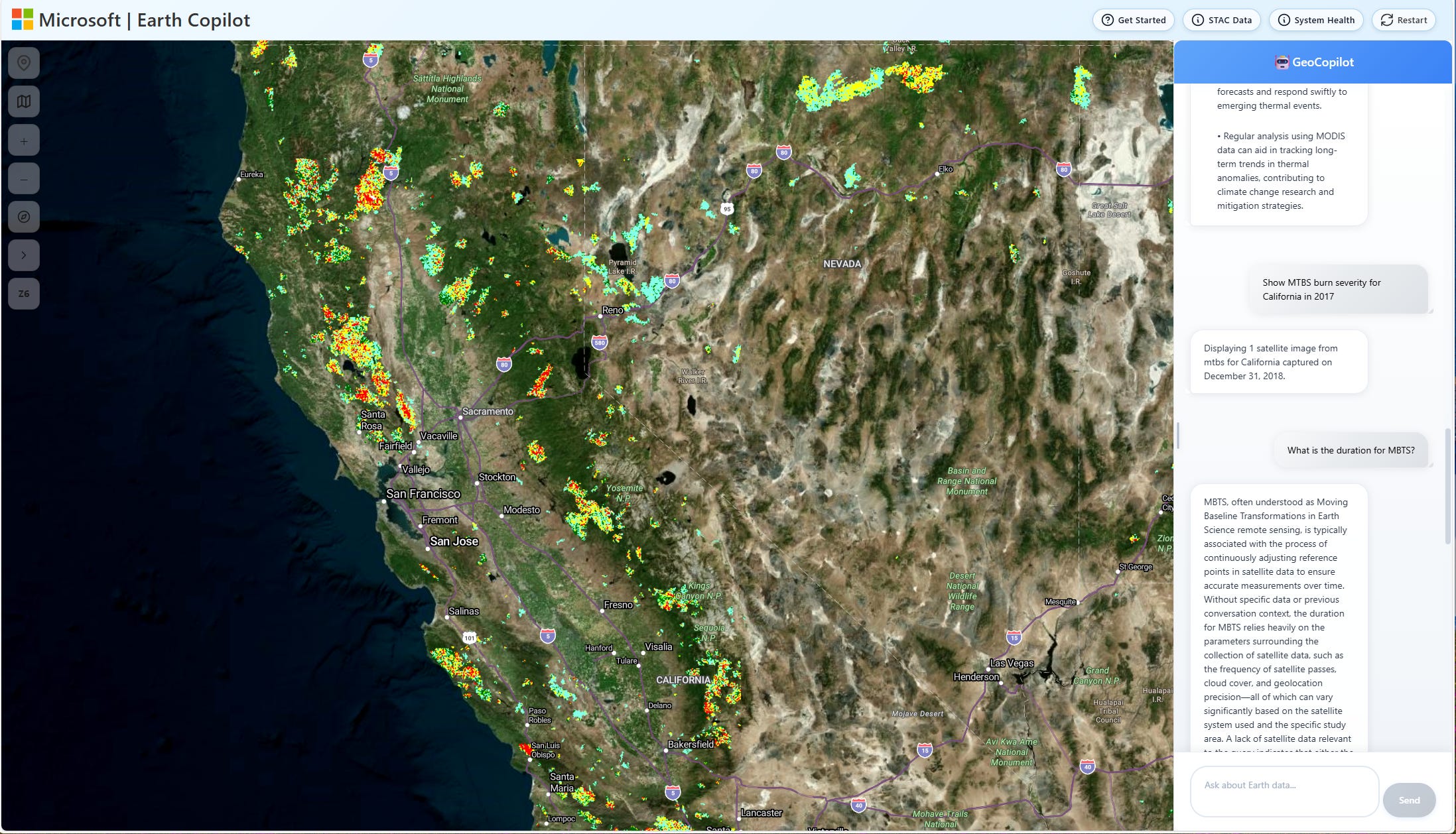
Microsoft’s Planetary Explorer is a reusable geospatial AI pattern that combines Planetary Computer data, STAC search, map rendering, multi-agent workflows, and natural-language interaction to help users explore, visualise, and reason over Earth science data without relying only on specialist GIS workflows.
deck.gl-raster v0.7 [link]
Development Seed’s deck.gl-raster v0.7 improves GPU-accelerated COG and Zarr visualisation with faster pixel filtering, lower startup latency for large COGs, centre-out tile loading and sharper high-density display rendering.
Accessing ESA BIOMASS Data from Python: A Practical Workflow Using Google Colab [link]
Elise Colin shares a lightweight Google Colab workflow for accessing ESA Biomass Level-1 products from Python through the MAAP API, selecting suitable scenes, generating Pauli RGB visualisations, and producing coarsely georeferenced GeoTIFFs for quick inspection in QGIS.
Data

CLMS Global Land Surface Temperature new version: reading the Earth’s thermal pulse [link]
Copernicus Land Monitoring Service’s Global Land Surface Temperature Version 3 provides free, open, hourly land-surface temperature estimates at 3 km resolution from 2018 to near real time, improving spatial detail, diurnal-cycle monitoring, quality information, and applications from agriculture and hydrology to urban heat and disaster management.
LGND Embeddings [link]
LGND AI has published Clay v1.5 embeddings for the Sentinel-2 L2A archive on Source Cooperative, turning around 2.8 million rasters and 2.2 PB of imagery into 15.2 billion open, commercially usable embeddings for similarity search, change detection, and downstream geospatial ML.
26 TB+ of geospatial data added to the gee-community-catalog.org this week [link]
26 TB+ of new geospatial data has been added to the GEE Community Catalog, including CTrees’ 100 m Global Aboveground Biomass dataset for 2000–2025, a 0.6 m NAIP-based canopy height model for the continental United States, and annual 30 m tillage maps for the U.S. Midwest.
Open Access to Earth Observation, Meteorology, and Ocean Data on the Atlantic Cloud [link]
The Atlantic Cloud is now open for access, with AIR Centre making Earth Observation data from its Azores receiving station available without an account. Users can browse and download MODIS collections, explore Sentinel-1 internal solitary wave detections, access meteorology and EO catalog APIs with free keys, and use `AtlanticCloud.jl` for programmatic access in Julia, with more collections and services planned.
Earth Data Hub Updates Its ERA5 Zarr Catalogue [link]
Earth Data Hub’s ERA5 Zarr mirror has been updated with April 2026 data, bringing its free catalogue of hourly and daily ERA5 and ERA5-Land datasets to more than 2 PB of cloud-ready reanalysis data.
ERA5 - Zarr mirror [link]
GAUL Level 1 and 2 Released [link]
FAO’s Global Administrative Unit Layers 2024 now include Level 1 and Level 2 administrative boundaries, providing standardised global vector layers with unified country, first-level, and second-level administrative coding for subnational analysis.
Administrative boundaries (level 1) - GAUL 2025 [link]
Administrative boundaries (level 2) - GAUL 2025 [link]

Snapshots
Can you see culture and traditions from space? [link]
Andrea Meraner shows how May Day Night bonfires can be seen from 36,000 km away in EUMETSAT MTG-FCI data, with the 3.8 µm and 10.5 µm channels helping reveal fire pixels linked to local spring traditions.
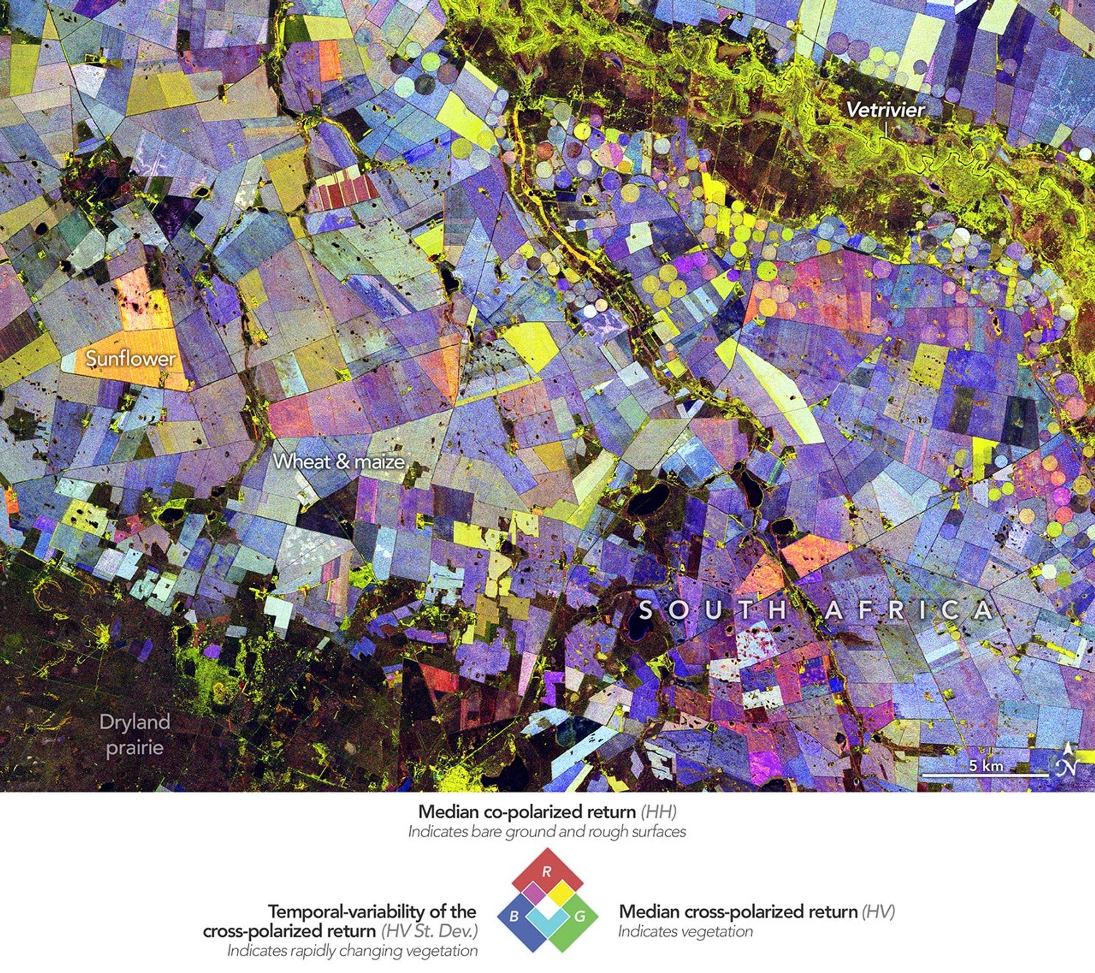
Painting the Growing Season in the Maize Triangle [link]
NASA Earth Observatory shows South Africa’s Maize Triangle through a multi-date NISAR L-band radar image, where colour differences reveal changes in crop fields, irrigation, and land use across the growing season.
Earth from Space: Batagaika Crater [link]
A Copernicus Sentinel-2 view of Batagaika Crater in Siberia, the world’s largest permafrost mega-slump, where thawing ground has formed a roughly 100 m deep, 1km long collapse feature that continues to expand in a warming landscape.
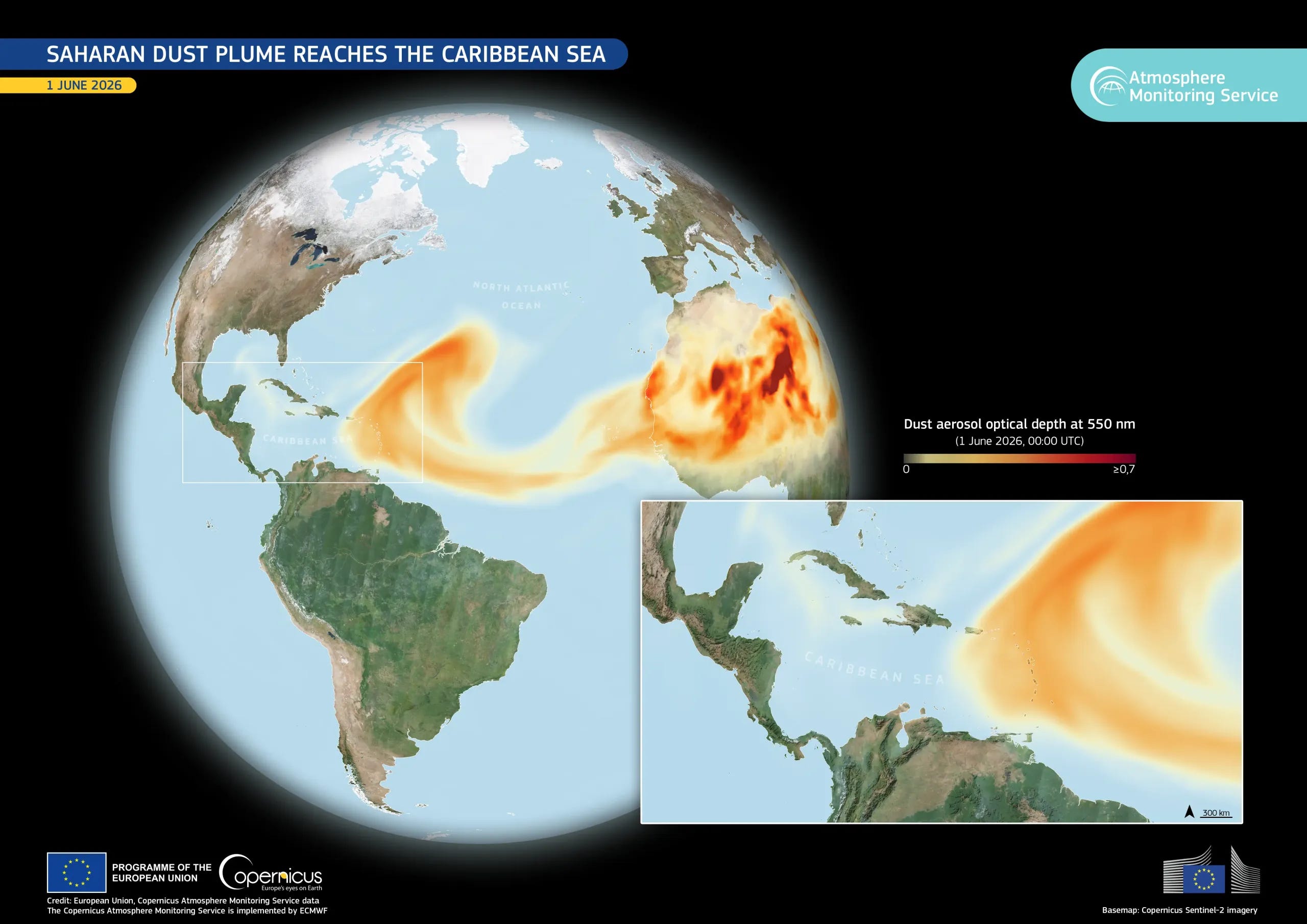
Saharan dust plume reaches the Caribbean Sea [link]
CAMS forecast data shows a Saharan dust plume stretching from West Africa across the North Atlantic to the Caribbean Sea on 1 June 2026.
Interesting read
Planetary Intelligence [link]
Will Marshall argues that today’s AI still knows far more about the internet than the physical world, and that satellite imagery and other sensor data could help build models that understand what is happening on Earth in near real time. He calls this “Planetary Intelligence”, with possible uses in disaster response, insurance, government oversight, security, and sustainability, and points to Planet’s work on natural-language access to its imagery archive as an early step in that direction.
The EO community probably does not need your weekend package [link]
In this essay, I write about why the EO community probably does not need another weekend package, and why more of that energy could go into maintenance, validation, documentation, upstream contributions, and the shared open-source tools we already rely on.
Climate — El Niño Watch
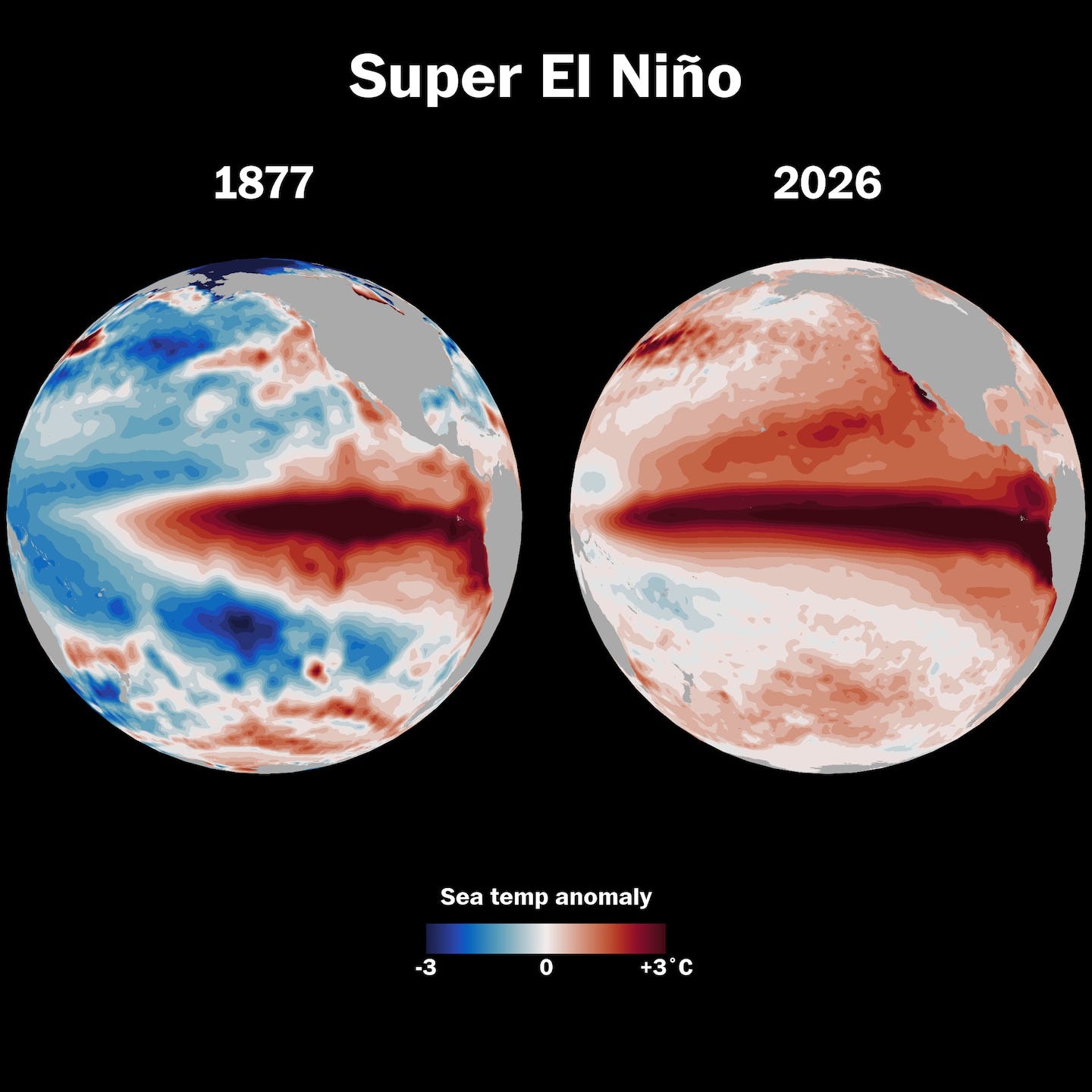
A super El Niño wiped out millions of people in 1877. Are we better prepared now? [link]
The Washington Post revisits the 1877–1878 super El Niño, which contributed to crop failures and famines that caused enormous global population losses, and asks what a comparable event would mean today. The article argues that modern climate monitoring, ocean observations, satellites, and seasonal forecasting make the world better prepared, while warning that extreme drought risks could still cascade through food, water, economic, and socioeconomic systems.
Related:
NASA-European Sea Level Mission Homes in on El Niño [link]
NASA/JPL reports that the Sentinel-6 Michael Freilich sea-level satellite has detected eastward-moving warm Kelvin waves in the equatorial Pacific, a signal that El Niño could develop later in 2026.El Niño/La Niña Update (May 2026) [link]
WMO’s May 2026 El Niño/La Niña Update reports a strong shift toward El Niño conditions, with warming central-eastern Pacific waters and an 80% probability of El Niño for June–August 2026, while stressing the need for early preparedness as above-average temperatures are forecast across much of the world.Prepare for El Niño, UN warns - it could be the strongest in decades [link]
BBC News reports that the UN/WMO is warning of a new El Niño phase that could strengthen through 2026, raising global temperatures and increasing the risk of extreme weather on top of human-driven climate change.
LinkedIn Highlights
“Don’t make me install a Python package just to access a specific dataset!” [link]
Ryan Abernathey’s environmental data hot take of the day: datasets should work with open standards and common tools, not require yet another dataset-specific Python wrapper.
From Spectral Reflectance

The Morning Backscatter
The Spectral Reflectance Newsletter is not always a quick read, so I started The Morning Backscatter as a shorter and lighter companion for the morning: one news item, one useful link, one visual, and one funny-ish item from the EO world.
There is no mailing list; new issues are published via GitHub Releases, and instructions on how to follow along are available in the repository README.
The Morning Backscatter: https://morningbackscatter.space/
GitHub repo: https://github.com/xen0f0n/morning-backscatter