
Level-2 News
ICEYE announces 2025 financials [link]
ICEYE exceeded €250 million in 2025 revenue, beating its own projections by 25%, as rising demand for SAR imagery linked to geopolitical tensions helped drive growth and support a planned expansion in satellite production capacity.
Planet Develops Novel Radio Communication Systems That Support Hybrid Space-to-Ground and Space-to-Space Connectivity [link]
Planet is developing new radio communication systems that combine space-to-ground and space-to-space links, effectively building a network that can route data across satellites and back to ground stations to reduce latency bottlenecks. The immediate implication is faster data delivery and better support for lower-latency applications, with Planet using its Pelican satellites to test and integrate capabilities such as Real Time Communications and high-speed downlink hardware into its fleet.
BlackSky Awarded Multi-Year Sole-Source $99 Million US Government IDIQ Contract for Advanced, Next Generation Capabilities [link]
BlackSky has won a multi-year, sole-source $99 million U.S. government IDIQ contract, with an initial $2 million award to speed the design of an advanced large-aperture optical payload for next-generation Earth Observation and space domain awareness platforms.
Airmo Earns 5 Million Euro in Seed Funding, Plans First Launch for 2027 [link]
Airmo has raised €5 million in seed funding to scale its methane-monitoring business and prepare for a first satellite launch in the second quarter of 2027, built around a compact sensor that combines short-wave infrared imaging and LiDAR to detect leaks from low Earth orbit.
Satellogic Plans Next-Gen Merlin EO Constellation [link]
Satellogic’s next-generation Merlin constellation is designed to deliver daily global mapping at one-metre resolution, with the first satellite planned for October 2026.
Copernicus Data Space Ecosystem Passes 600,000 Registered Users [link]
The Copernicus Data Space Ecosystem has surpassed 600,000 registered users worldwide, a milestone the post presents as reflecting growing global use of Earth Observation data and the role of scalable cloud services in supporting access, retrieval, processing, and practical applications.
Wyvern Partners With NSG UP42 to Expand Hyperspectral Tasking in Saudi Arabia [link]
Wyvern announced a partnership with Neo Space Group UP42 to make its Dragonette hyperspectral data available for tasking in Saudi Arabia, for applications in agriculture, environmental monitoring, resource management, and infrastructure development through standardized, analysis-ready data.
Groundsource: using AI to help communities better predict natural disasters [link]
Groundsource uses Gemini to turn unstructured global news reports into a historical flash-flood dataset that supports urban flood forecasting with up to 24 hours of lead time.
Related:
Introducing Groundsource: Turning news reports into data with Gemini [link]
Protecting cities with AI-driven flash flood forecasting [link]
Another Earth Raises $4M to Expand AI Platform for Synthetic Satellite Data [link]
Vienna-based startup Another Earth has raised $4 million in seed funding to expand its platform for generating synthetic satellite imagery and environmental scenario simulations, aimed at producing labelled geospatial training data for AI models used in environmental and operational risk detection.
Developer's Orbit
Similarity Search with Embeddings [link]
An xarray and Dask workflow uses open AlphaEarth Foundations embeddings to find grain silos in Franklin County, Kansas through cosine similarity search.
Characterizing Census Blocks with Satellite Embedding Statistics [link]
Alpha Earth Foundation embeddings can be aggregated to census blocks and used as tabular features, with a simple logistic regression separating urban and rural blocks at 92.5% accuracy.
Segmenting Cattle Operations with AlphaEarth Embeddings in Barton County, Kansas [link]
Earth Genome has published a case study from Barton County, Kansas showing how AlphaEarth embeddings, spatial priors, and a lightweight Random Forest workflow can be combined to segment cattle feedlots into lots, ponds, and background at pixel level, with the aim of better estimating facility footprints and environmental impacts.
STAC: A common language for finding geospatial data | Scene from Above S15E5 [link]
An overview of STAC as a standard for discovering and accessing geospatial data, with emphasis on its growing industry adoption.
Pangeo Showcase: “Visualizing Zarr with zarr-layer” [link]
zarr-layer renders Zarr data directly as a native custom layer in MapLibre or Mapbox, selecting intersecting chunks at the current resolution and handling reprojection on the GPU.
AlphaEarth Foundations Satellite Embeddings: A Look at Our Planet in 2025 [link]
Google’s 2025 update to the AlphaEarth Foundations Satellite Embedding dataset introduces a global annual layer that compresses a year of multi-source satellite data into 64-dimensional, 10-metre embeddings, aimed at making year-over-year surface change analysis faster and easier.
RaQuet: Raster Data in Apache Parquet [link]
RaQuet is an open specification and CLI for storing raster data in standard Apache Parquet files so it can be queried with SQL across modern analytics engines, effectively acting as a raster counterpart to GeoParquet for the data warehouse and lakehouse world.
Streaming millions of TESSERA tiles over HTTP with Zarr v3 [link]
Anil Madhavapeddy describes a Zarr v3 layout for streaming TESSERA geospatial embeddings over HTTP, reorganising millions of per-tile NumPy files into sharded annual stores designed to support both lightweight pixel-level access and larger regional analysis with only a small number of range requests.

Data
Overture Maps Foundation now offers a STAC catalogue with all their datasets [link]
Overture Maps Foundation now offers a STAC catalogue for all of its datasets, making them easier to browse and access through a familiar geospatial data standard.
OceanBench — Evaluating AI Ocean Models [link]
OceanBench is an open benchmark from Mercator Ocean for evaluating ocean forecasting systems against reference ocean analysis datasets, reanalyses, and observations, with a public interface for comparing scores and an open-source GitHub project for broader use and contribution.
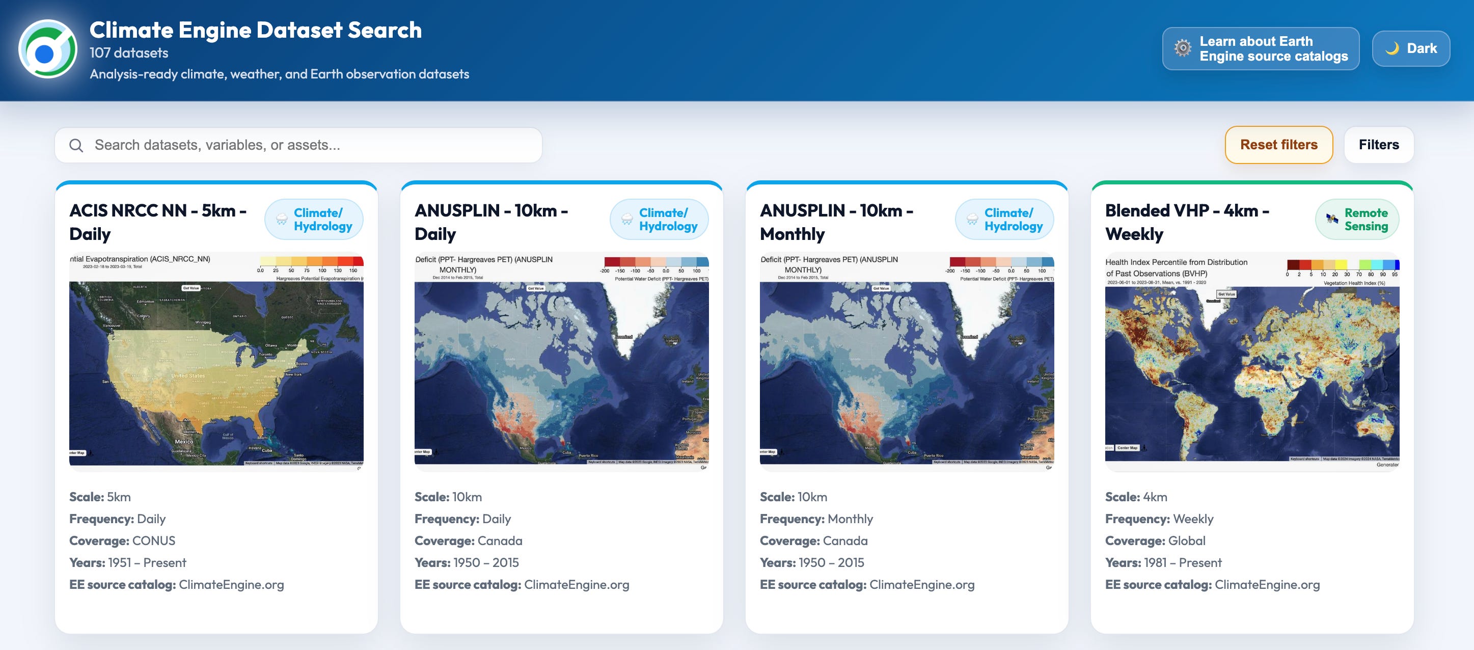
New Dataset Search Tool in Climate Engine [link]
Climate Engine has introduced a new dataset search tool to help users navigate its 100+ datasets by filtering for variables, time period, frequency, geographic coverage, catalog source, and spatial resolution, while also linking to documentation and public JSON metadata for developers.
Search tool at https://app.climateengine.org/dataset_search
Related:
Data Stories: 10 Maps to Spark Exploration with Climate Engine [link]
New NECCTON Ocean Viewer opens access to next-generation marine ecosystem data [link]
Copernicus Marine has launched the NECCTON Ocean Viewer as a new tool for exploring next-generation marine ecosystem data, opening access to information on marine ecosystem dynamics through an interactive viewer.
HeiGIT Expands Risk Assessment Datasets to 119 Countries [link]
HeiGIT’s risk assessment datasets are now available for 119 countries through the Humanitarian Data Exchange, expanding open access to hazard exposure data designed to support anticipatory action, disaster preparedness, GIS-based risk assessments, comparative analysis, and operational decision-making.
Explore the datasets [link]
New Soil Water Index datasets bring deeper insight into global soil moisture [link]
Copernicus Land Monitoring Service has released the updated Soil Water Index 0.1° Version 4 products, providing daily and ten-daily global soil moisture estimates from 2007 to the present by combining satellite observations with modelling to track moisture conditions across different soil depths.
Snapshots
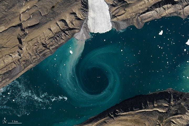
Cañon Fiord’s Whirling Waters [link]
Landsat 8 captured swirling eddies in Cañon Fiord during the 2022 Arctic summer melt season, with fractured sea ice and turquoise sediment plumes tracing currents shaped by meltwater, glacial flour, and seasonal ice breakup.
Interesting read
EarthCARE tracks how ship emissions transform clouds [link]
Ships are the biggest source of human-made sulphur dioxide emissions over the oceans, and the clouds left in their wake, known as ship tracks, can differ markedly from nearby clouds. This EarthCARE image uses observations from the Multispectral Imager to show how these emissions can alter cloud properties from space.
NASA’s PACE Satellite Provides New Pollution Measuring Product [link]
NASA’s PACE satellite now offers a new nitrogen dioxide product that extends the mission’s capabilities beyond ocean and aerosol measurements to track a harmful air pollutant linked to fossil fuel and wood burning. By combining OCI observations with training from Sentinel-5P’s TROPOMI instrument, the new product enables finer-scale pollution monitoring, helping researchers identify sources as small as individual factories or highway corridors.
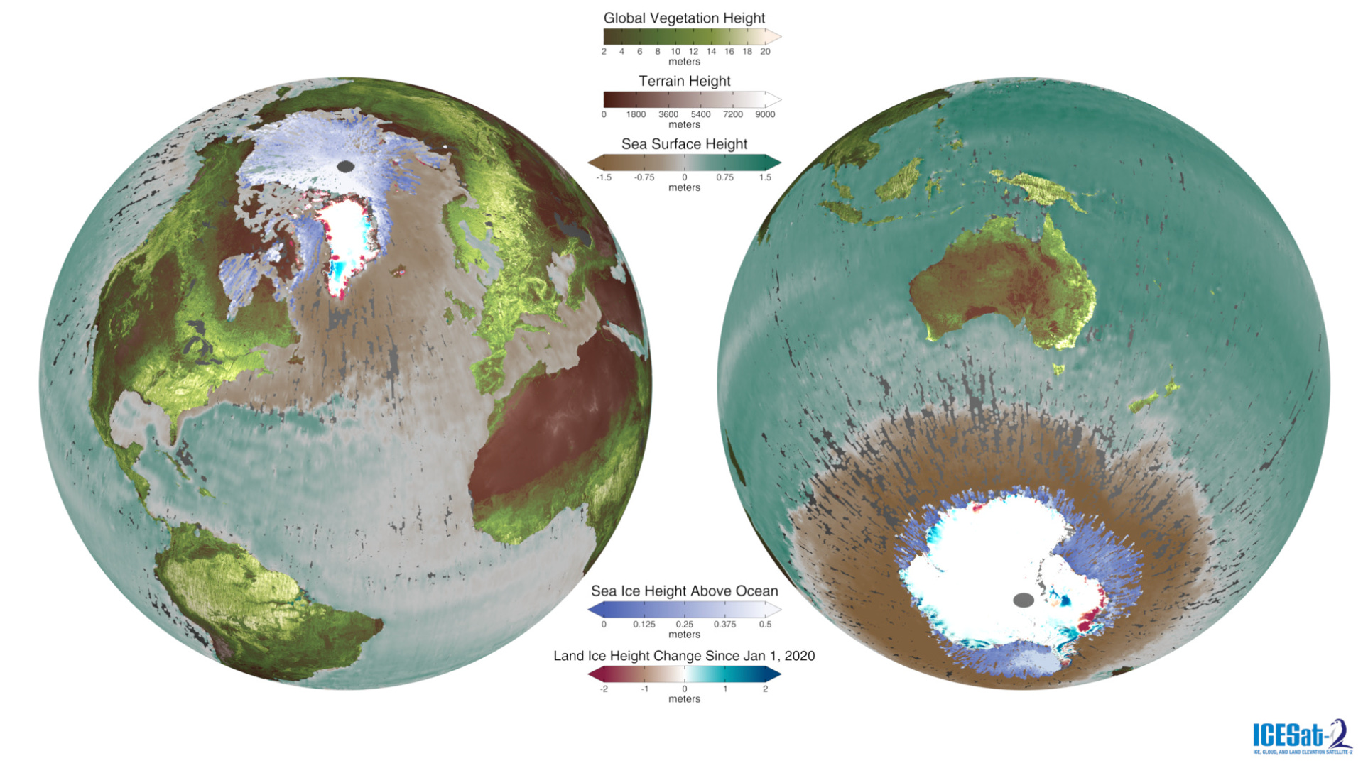
Global Views of ICESat-2 Data [link]
NASA’s Scientific Visualization Studio has released a rotating-globe visualisation of ICESat-2 data products, showing how the mission’s laser altimeter measures land and ice elevation, sea ice, ocean surface height, forests, clouds, and aerosols to track changes in Earth’s surface and atmosphere.
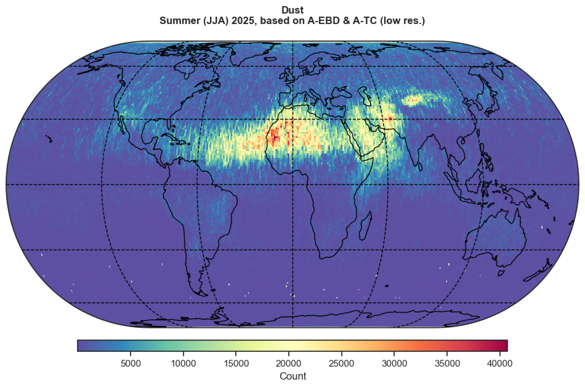
EarthCARE maps vast atmospheric dust trails [link]
EarthCARE is mapping large atmospheric dust plumes, using its observations to show the global distribution and movement of mineral dust in the atmosphere and to improve understanding of how these aerosols affect radiation, clouds, and climate.

Spotlight on an instrument: Copernicus Sentinel-5 [link]
Copernicus Sentinel-5, the Ultraviolet Visible Near-infrared Short-wave infrared (UVNS) spectrometer aboard Metop Second Generation A, will deliver near-global daily observations of ozone, nitrogen dioxide, sulphur dioxide, methane, carbon monoxide, aerosols, and wildfire smoke to support air quality monitoring, ozone-hole tracking, and climate applications.
If AI Is Going to Task Satellites, We Need Standards [link]
Element84 makes the case that enabling AI systems to task satellites at scale will require a practical, widely adopted tasking standard rather than one designed to describe every possible sensor state.
Takeaways from the First Geospatial Vector Embeddings Standards Sprint [link]
Jason Gilman’s takeaways from the first geospatial vector embeddings standards sprint point to growing agreement around Zarr, a draft STAC extension, and the need for clearer terminology and stronger model documentation.
LinkedIn Highlights
GeoPackage Still Has a Place Alongside Parquet [link]
Mark Litwintschik writes that GeoPackage still has a place alongside Parquet when bundled styling or editable data matter, with DuckDB v1.5.0 also improving GeoPackage generation speed and adding support for structs.
Against the “Built It Alone” AI Narrative [link]
Jonas Sølvsteen calls for less emphasis on “look what I built alone with Claude over the weekend” narratives and more attention to how AI can be used productively in collaborative creative environments, pointing to GDAL’s open-source contribution policy as an example.
Learning
An assortment of GTC sessions for weather & climate enthusiasts [link]
Sanjay Choudhry selects a set of NVIDIA GTC sessions for weather and climate audiences, covering AI-powered climate risk ensembles, climate system digital twins, kilometre-scale Earth system modelling, Earth-2 for resilience, and geospatial workflow acceleration.
Monitoring Climate Change from Space Webinar Series #1 | Satellite Retrievals of CO2 and Methane [link]
This ESA webinar offers an overview of space-based observations of CO2 and methane, explaining how satellite measurements are turned into atmospheric concentration estimates and used to assess human-made emissions and natural sinks, while also highlighting the ESA GHG-CCI project and its links to wider climate services and related initiatives.