

Level-2 News
Maxar to be Acquired by Advent International for USD 6.4 Billion [link]
“Maxar Technologies has announced that it has entered into a definitive merger agreement to be acquired by the global private equity investor Advent International, at an enterprise value of approximately USD 6.4 billion. The announcement was made on December 16.”
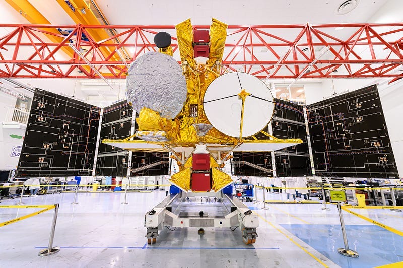
Successful launch for NASA’s SWOT satellite [link]
The Surface Water and Ocean Topography (SWOT) satellite launched on December 16, 2022 onboard a SpaceX Falcon 9 rocket from the Vandenberg Space Force Base in California.
With a mission to measure ocean topography and equiped with the instruments to measure the height of water with centimeter accuracy, SWOT will provide data that are important to mapping sea-level rise, tracking floods and droughts and studying ocean currents and eddies.
SWOT carries a new class of altimeter, the Ka-band Radar Interferometer, known as KaRIn, which acquires measurements at Ka-band (35.75 GHz) and has a swath coverage of about 120 km.
Related:
A New NASA Satellite Will Map Earth’s Rising Seas [link]
Two satellites to better understand the planet [link]
World-first satellite to measure Earth’s water levels launches [link]
KaRIn: Ka-band Radar Interferometer [link]
Planet Makes Its Geospatial Data Available Through Amazon SageMaker [link]
“Planet Labs announced it is making geospatial data available through Amazon SageMaker, a fully managed machine learning (ML) service from Amazon Web Services (AWS). Now, Planet data can be directly embedded into Amazon SageMaker, allowing data scientists and ML engineers to acquire and analyze global, daily satellite data. With this data, customers can train, test, and deploy ML models all within Amazon SageMaker.”
Europe’s Vega C rocket fails on 2nd-ever mission, 2 satellites lost [link]
The Vega C launch vehicle lifted off as scheduled on December 20, 2022, but an anomaly occured on the rocket’s second stage led to the premature end of the mission. Under standard procedure, the order of destruction of the launcher was given by CNES and the vehicle and its Pléiades Neo Earth observation satellites crashed down into the Atlantic.
The incident prompted the appointment of an independent inquiry commission, tasked with analyzing the reasons for the failure. [link]
Developer’s Orbit
The winning solution for the AgriFieldNet Competition is out [link]
Check out the winning solution for the AgriFieldNet Competition. The main goal of the competition, organized by Radiant Earth Foundation and IDinsight, was to classify crop types in agricultural fields across Northern India using multispectral observations from Sentinel-2 satellite.
The team that submitted this solution used a blend of different models (a U-Net and several gradient boosting-based methods) and weighted their outputs to decide on the final crop type.
You can find the implementation in this Github repo [link].
Interesting reads

A Year in Pictures: Capturing 2022’s Interconnected World [link]
In this Medium story, Planet reflects on the past year as they captured it from orbit. From erupting volcanos to the war in Ukraine and from floods and droughts to hurricanes, we see changes at scale that transform our planet.
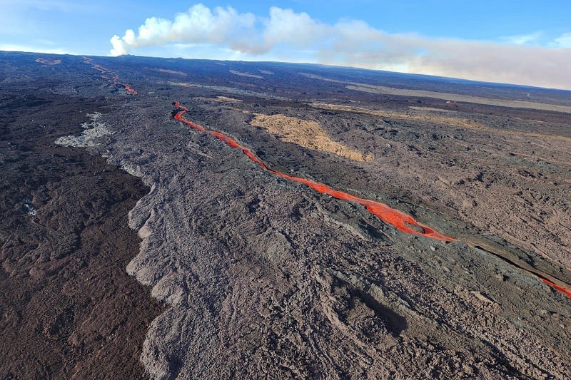
Sizing up Mauna Loa’s Lava Flows [link]
After a NASA aircraft conducted a series of flights over the volcano and mapped the volcano’s topography with a Ka-band instrument called GLISTIN-A, teams at NASA’s Jet Propulsion Laborary and the United States Geological Survey (USGS) compared the data to pre-eruption topography maps to estimate the thicknes of the lava flows.
“Over the roughly 14-day eruption, Mauna Loa erupted more than 8.8 billion cubic feet (230 million cubic meters) along a lava flow that extended up to 16.5 miles (19.5 kilometers) from the vent, according to the USGS.”
La Niña [link]
In Issue #55 of Planet Snapshots, you can read all about La Niña and how the phenomenon is associated with floods and droughts as water is shifted away from the southern US and towards Asia and Australia.
Learning
Beyond the Visible — Imaging Spectroscopy for Agricultural Applications [link]
“This course will provide you with the fundamentals of imaging spectroscopy specifically for agricultural applications and gives you access to free data sources, open-source software and hands-on training exercises.”
Machine Learning in Weather & Climate [link]
“The objective of the MOOC is to train a wider community on the impact and use of Machine Learning in numerical weather and climate predictions. It brings together experts throughout Member and Co-operating States and beyond to provide a shared vision across the communities of Earth system sciences, high-performance computing and Machine Learning.”
Starting on 09/01/2023