
Level-2 News
NASA Selects Two Earth System Explorers Missions [link]
NASA has selected two Earth System Explorers missions, STRIVE and EDGE, for continued development, with confirmation reviews planned for 2027 and launches no earlier than 2030. STRIVE is designed to deliver daily, near-global vertically resolved measurements of atmospheric temperature, aerosols, ozone, and trace gases, while EDGE will map 3D ecosystem structure and the surface topography of glaciers and sea ice, extending capabilities beyond ICESat-2 and GEDI.
German AI company LiveEO launches its own satellite constellation to monitor critical infrastructure [link]
LiveEO announced Twinspector, a new high-resolution 3D Earth observation satellite constellation built with German partners to support large-scale monitoring of critical infrastructure.
ESA’s Earth Observation programme now has its own linkedin page [link]
Earthmover announced a Data Marketplace [link]
Earthmover launched a cloud-native Data Marketplace for weather, climate, and EO datasets, offering instant access to analysis-ready data (no downloads or ingestion) in Icechunk format from providers like ECMWF/NOAA and several AI-forecast partners.
UK Space Agency Seeks Satellite Direct-to-Device Solutions for Delayed Emergency Services Network [link]
The UK Space Agency has asked industry for proposals to add satellite direct-to-device connectivity to the UK Emergency Services Network, aiming to close rural and coastal coverage gaps and provide resilient messaging and location services when terrestrial networks fall short.
Arianespace to launch first batch of Amazon Leo satellites with the first Ariane 64, on February 12, 2026 [link]
Arianespace announced that the first Ariane 64 flight (VA267) is scheduled for Feb 12, 2026 from French Guiana, deploying 32 Amazon Leo satellites and kicking off a planned 18-launch series for the constellation.
Tomorrow.io Announces $175M Financing to Deploy DeepSky, The World’s First AI-Native Weather Satellite Constellation [link]
Tomorrow.io announced a $175M financing round to accelerate deployment of DeepSky, described as an AI native weather satellite constellation designed to increase atmospheric observation density and refresh rates for forecasting and decision intelligence, building on its first 13 satellite constellation that it says already delivers 60 minute global revisit.
Vantor Wins NGA Luno B Contract to Deliver AI-Powered Global Change Detection [link]
Vantor won a $5.3M National Geospatial-Intelligence Agency Luno B contract to deliver AI-powered global change detection by fusing data from multiple satellite constellations, including electro optical and SAR, to rapidly flag terrain and land cover changes and help keep NGA mapping products up to date for missions ranging from disaster response to conflict monitoring.
Brazil’s Amazonia-1B Satellite to Be Launched Aboard Vega C [link]
Brazil’s INPE selected SpaceLaunch to fly the Amazonia-1B Earth observation satellite on Avio’s Vega C in 2027, expanding Brazil’s capability to monitor Amazon deforestation and support national agricultural mapping.
Singapore to set up national space agency on April 1 to develop and run space capabilities [link]
Singapore will launch the National Space Agency of Singapore on April 1, bringing satellite tasking, geospatial analytics, and space-safety capabilities under one national hub.
ExoAnalytic to build fire tracking visualisation tools for Earth Fire Alliance [link]
ExoAnalytic will develop visualization tools for Earth Fire Alliance’s FireSat, letting users see real-time and upcoming satellite tracks plus the 1,500-km swath footprints as the system expands beyond the March 2025 protoflight built by Muon Space.
From Satellite to Production Site: A Pilot Project for Integrating AI into Global Supply Chain Mapping [link]
Open Supply Hub and Earth Genome are running a 12-month pilot funded by Patrick J. McGovern Foundation to use satellite imagery + the Earth Index and a human-in-the-loop workflow to uncover and verify previously unmapped production sites, expanding open supply-chain transparency.
Exotrail and Astroscale France join forces to build deorbiting capability for LEO [link]
French startups Exotrail and Astroscale France have partnered on a France 2030–backed plan to demo a LEO deorbiting mission—combining Exotrail’s service vehicle with Astroscale’s rendezvous/proximity tech, pending government selection (decision expected by summer 2026) with a target launch around 2030.
constellr launches commercial partnership with Japan’s premier space solutions provider SKY Perfect JSAT [link]
SKY Perfect JSAT and constellr announced a commercial partnership to sell constellr’s high-resolution thermal infrared satellite data in Japan via SKY Perfect JSAT, with use cases including urban heat monitoring, wildfire detection, and infrastructure and maritime activity monitoring.
Europe’s digital Earth gets ready to grow user community [link]
Destination Earth (DestinE) is preparing to widen access ahead of Phase 3 (starting July 2026), with ESA (platform/services), EUMETSAT (data lake/edge) and ECMWF (digital twins/engine) planning a faster, more user-oriented platform from June 2026, an open call to add services, and continued growth beyond the 5,000+ current users.
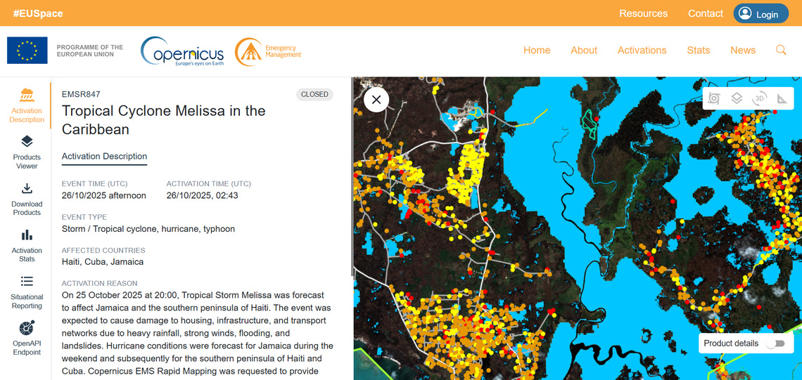
Launch of the new Rapid Mapping Viewer [link]
Copernicus EMS is launched a redesigned Rapid Mapping Viewer, adding in-app stats, activation API links, a new topographic basemap, and full mobile support while keeping all existing features.
Developer's Orbit
“annual” EO embeddings can capture sub-annual signals [link]
This could as well be a standalone blog post (and/or a published paper):
Samuel Barrett and Madeline Lisaius argue that “annual” EO embeddings can still preserve sub-annual signals, because the training objective encourages the model to encode salient events even when observations are sparse.
The practical takeaway is: if full-year embeddings already perform well, don’t over-specialise; and if you truly need in-season representations, you’ll likely need a model trained for that window, not just fewer input dates.
EnMAP-Box 3.17.1 is now available for download [link]
EnMAP-Box 3.17.1 is now available, adding a new Spectral Index Explorer for one-click index previews plus a revamped, more capable spectral library viewer with an interactive legend.
Introducing Async-GeoTIFF [link]
Async-GeoTIFF is a new high-level Python library for reading GeoTIFFs and COGs with async I/O, designed to make concurrent cloud reads faster and easier.
Improved forest carbon estimation with AlphaEarth Foundations and Airborne LiDAR data [link]
John Kilbride shared a workflow on the Google Earth / Earth Engine blog showing how to combine AlphaEarth Foundations embedding fields with airborne LiDAR to map forest structure for carbon monitoring and verification. They argue the embeddings can replace a lot of the usual satellite preprocessing and data-fusion overhead, making it easier to build repeatable, scalable mapping pipelines.

Data
NISAR Sample Data Products Available [link]
NASA and ISRO have released 25 sample NISAR Level 1–3 L-band data products to help users test workflows ahead of larger releases later in 2026, noting the datasets are not yet fully calibrated and include known artifacts and limitations discoverable via Earthdata Search and Vertex.
Related:
Available NISAR Data [link]
NASA and CNES Release Unprecedented Global River Discharge and Water Quality Estimates [link]
NASA and CNES released new SWOT Level 4 global river discharge and suspended-sediment estimates (including a consensus “SWOT Discharge”), generated with the open-source Confluence framework and now available via PO.DAAC and NASA Earthdata Search.
Land Surface Phenology V2: a new global reference for monitoring vegetation dynamics [link]
Copernicus Land Monitoring Service Land Surface Phenology V2 (LSP V2) is a new global 300 m annual dataset (released each March) that harmonises PROBA-V (2014–2018) and Copernicus Sentinel-3 OLCI (2019–present) to deliver 13 consistent, PPI-based vegetation seasonality metrics with quality flags for monitoring climate impacts on ecosystems, drought, agriculture, and biodiversity worldwide.
Expanding access to Met Office data through the Microsoft Planetary Computer [link]
The Met Office has published its UK deterministic (2 km) and global deterministic (10 km) forecast datasets on Microsoft’s Planetary Computer. The release includes the latest forecasts plus a two-year archive of prior forecasts (over 600 TB), catalogued with STAC for easier discovery and programmatic access.
Landsat 8 and 9 data available in Copernicus Browser [link]
Copernicus Browser now includes ongoing Landsat 8 & 9 imagery, adding long-term optical + thermal observations (OLI/TIRS) as a complement to Sentinel-2, with Level-1 archive access from 2021 onward for viewing and quantitative analysis.
Planet’s Open STAC Catalog now has newly released open hyperspectral data [link]
~100 new scenes with expanded global coverage, improved metadata, three new application categories, full core imagery assets, plus methane and max-sensitivity examples for select GHG scenes.
CMIP6 Climate Projections Now Live in Earth Data Hub as Zarr Datasets [link]
Earth Data Hub now serves CMIP6 climate-model projections as ready-to-use Zarr datasets, starting with ~3TB of daily historical + ScenarioMIP data for six widely used models, so you can explore scenarios interactively with just Xarray/Zarr (plus a tutorial + repo), with more models planned.
constellr thermal data now accessible via ESA Third Party Missions programme [link]
constellr’s SkyBee-1 and SkyBee-2 thermal infrared data is now available for non-commercial scientific research via ESA’s Third Party Missions programme, giving researchers access to operational land-surface temperature products through an ESA Announcement of Opportunity.
Snapshots
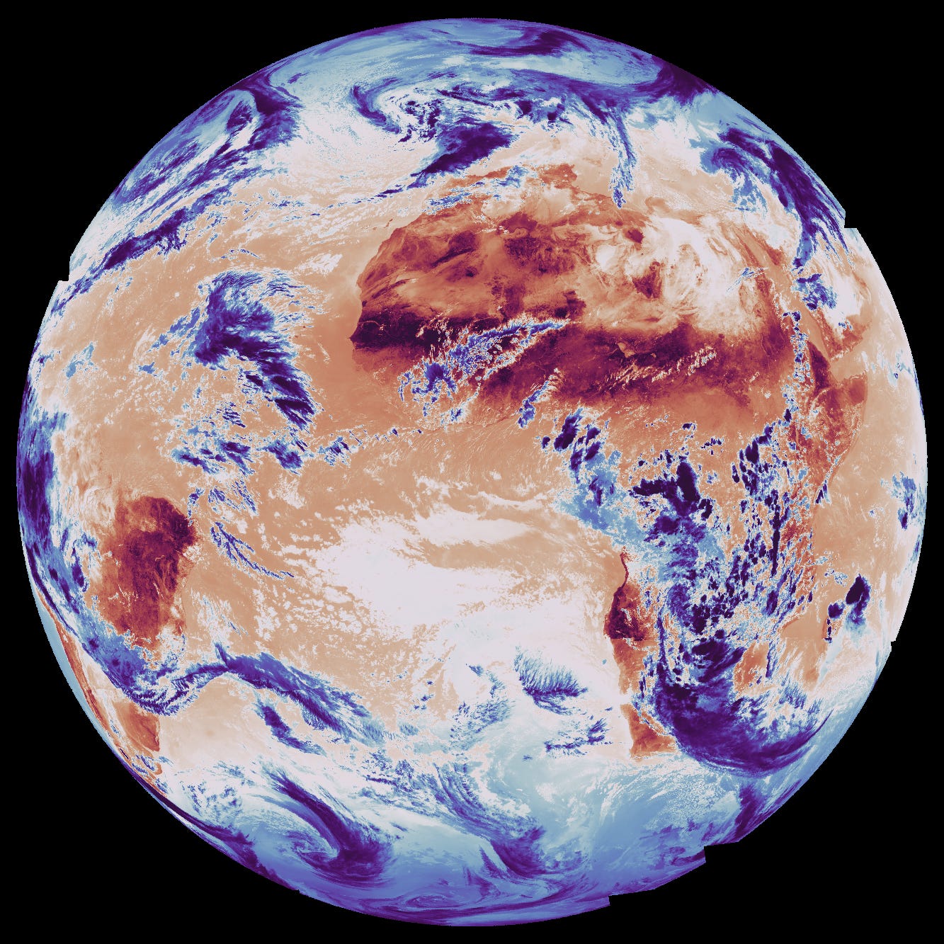
Europe’s next-generation weather satellite sends back first images [link]
"The first images from the Meteosat Third Generation-Sounder satellite have been shared at the European Space Conference in Brussels, showing how the mission will provide data on temperature and humidity, for more accurate weather forecasting over Europe and northern Africa."
Related:
See into Earth’s atmosphere like never before [link]
Interesting read
Visions of Earth Intelligence [link]
Bruno Sanchez-Andrade Nuño argues that “Earth Intelligence” is less about collecting more satellite data and more about reducing the effort to answer “where is what” questions at planetary scale. He compares agentic workflows, embedding-based compression, and retrieval-first indexing, and makes the case that treating embeddings as an index can enable faster, cheaper discovery; then hand off to heavier models when deeper validation is needed.
Predicting Earth Observations [link]
Development Seed introduced EO Predictor, a map-first tool that estimates where and when upcoming Earth observations may occur over the next 48 hours, using orbit data (via CelesTrak) and an automated pipeline to help users, especially disaster responders, find relevant imagery faster.
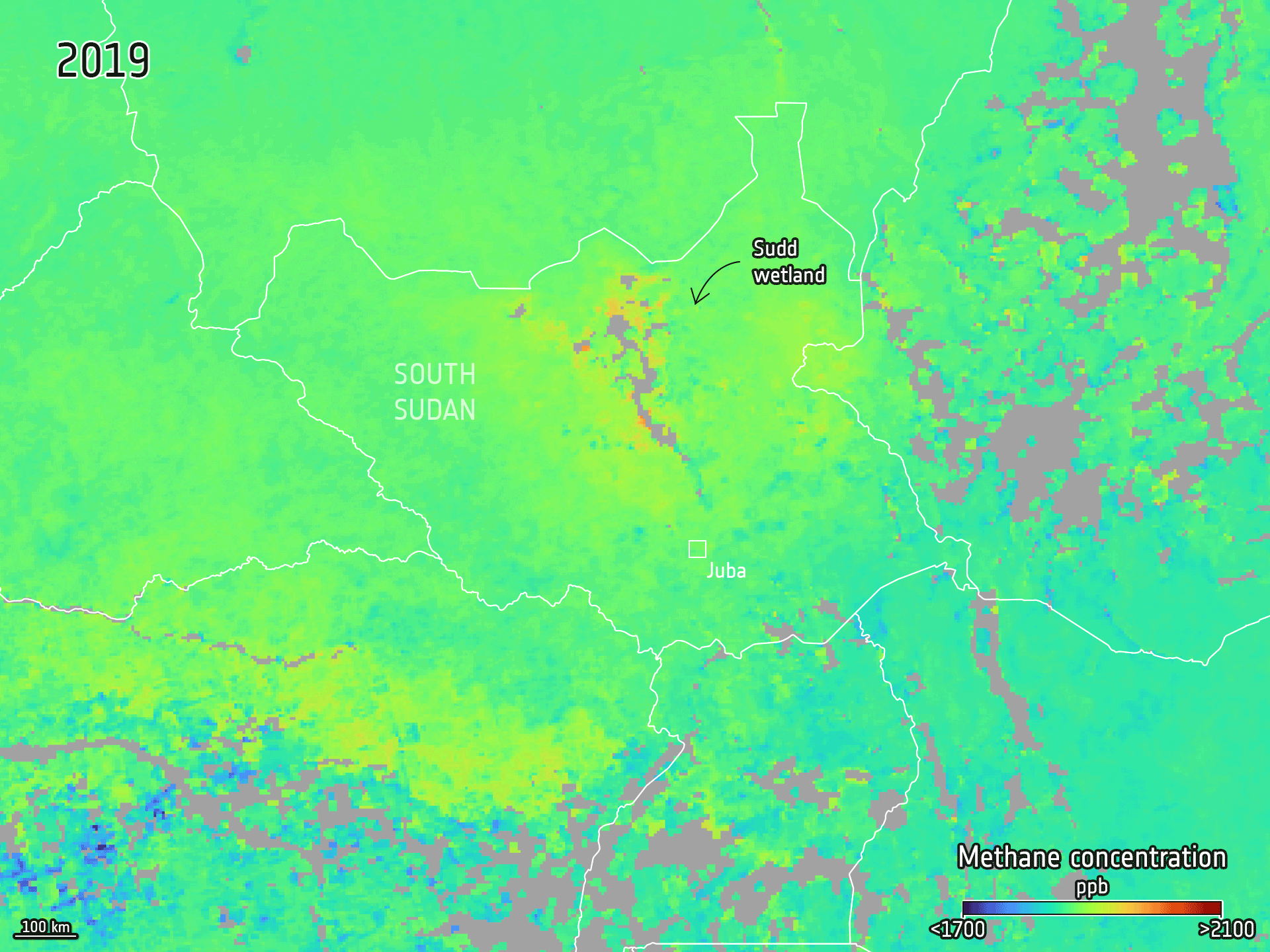
The curious case of why methane spiked around Covid [link]
ESA highlights a new Science study led by Philippe Ciais that reconstructs the 2019–2023 methane budget and explains why methane rose so sharply in 2020–2022, then slowed. The study points to a temporary dip in the atmosphere’s methane “sink” (lower hydroxyl radicals during lockdown-era chemistry changes) alongside higher wetland emissions under unusual climate conditions, with fossil fuels and wildfires playing a smaller role in that spike.
Related:
Paper: Why methane surged in the atmosphere during the early 2020s [link]
How the EU Space Programme supports agriculture [link]
How the EU Space Programme supports agriculture, from CAP parcel monitoring with Sentinel 1 and Sentinel 2 to drought tracking and precision farming enabled by Galileo and EGNOS, with practical examples of how satellite data is making subsidy checks, water management, and farm operations more efficient and sustainable.
15 years of TanDEM-X – DLR’s pioneering Earth observation mission celebrates its anniversary [link]
DLR marks 15 years since TanDEM-X began operational acquisitions in December 2010 to generate a global digital elevation model that has since become a topographic reference, including as the freely accessible Copernicus DEM released in 2016. The mission flies the twin satellites TerraSAR-X (15 June 2007) and TanDEM-X (21 June 2010) in close formation for interferometric radar measurements, which are processed at Oberpfaffenhofen into a consistent global DEM with one-metre absolute vertical accuracy on a 12 m grid. Although designed for five years, the satellites have continued operating, enabling additional coverages and DEM change maps via DLR EOC Geoservice, with an independent 2017–2020 DEM planned via the TanDEM-X Science System from early 2026. Airbus Defence and Space markets the data commercially, while DLR is also outlining successor concepts such as MirrorSAR to improve DEM accuracy further.
For better winter weather forecasts – HALO measurement flights over the North Atlantic [link]
An international research team has started the NAWDIC field campaign to improve winter weather forecasting by collecting high-detail observations over the North Atlantic, a region where routine measurements are limited. Using DLR’s HALO aircraft, equipped with lidar instruments including WALES (water vapour) and the first-use HEDWIG (wind) payload, the project will record continuous vertical profiles of wind, ozone, and humidity between the aircraft and the surface. The six-week campaign, launched on 13 January 2026 with flights based from Shannon Airport in Ireland, focuses on processes such as dry intrusions that can influence storms, heavy rainfall, and cold spells downstream across Western Europe, with the goal of feeding better observations into weather and climate models.
Arctic Weather Satellite paves way for constellation [link]
ESA’s Arctic Weather Satellite (launched Aug 2024) has proven the small-satellite approach and delivered microwave radiometer humidity/temperature data that ECMWF deemed so good it is being assimilated into forecasts. EUMETSAT confirmed the Polar System – Sterna constellation will go forward with first launches planned for 2029 (six satellites plus spares, replenished to deliver data to at least 2042).
Podcasts
EOcafe: ESA CM25 outcomes and opportunities: what’s next for the EO industry?
Scene From Above: S15E4: What “cloud-friendly” really means for Earth observation [link]
In a Scene from Above interview, Development Seed data engineer Aimee Barciauskas explains that “cloud-friendly” Earth data is about network-optimized delivery and the surrounding ecosystem (metadata, indexes, libraries, interfaces), not just putting files in the cloud. Drawing on work with NASA’s ODSI/IMPACT, MAAP, and VEDA, she also highlights community efforts (Pangeo, CNG, ESIP) and the push toward more reproducible workflows.
LinkedIn Highlights

The GeoTIFF: The Raster That Survived the ‘90s [link]
Some thoughts on AI writing [link]
"Reading something that is imperfect is a real treat these days."
Call for Abstracts
EarthCARE Science and Validation Workshop 2026 [link]
Deadline 27 February 2026
Upcoming Events
Announcing Sprints to Define Best Practices for Earth Observation Vector Embeddings [link]
"CNG, Planet, and Clark University are convening a two-day in-person sprint on March 10-11, 2026 at Clark University in Worcester, Massachusetts focused on defining patterns and best practices for Earth observation (EO) vector embeddings. The goal of this sprint is to collaboratively draft and align on a practical specification that can be tested, extended, and adopted by the broader EO community."
CDSE Webinar: Creating scalable EO workflows with CDSE, EarthCODE, and APEx [link]
A webinar on how Copernicus Data Space Ecosystem works with EarthCODE and APEx to move from tested EO experiments to scalable services via openEO, presented by VITO’s Bram Janssen.
Learning
First Basemap [link]
This step-by-step class shows how to generate a global interactive map using OpenStreetMap and PMTiles, powered by GitHub Actions and Amazon Web Services, then style and ship it with MapLibre.
Introduction to GDAL’s New Command Line Interface
5th NASA ICESat-2 data training webinar: "Laser Altimetry Applications for a Changing World: Working with ICESat-2 Inland Surface Water Data" [link]
Presentation Slides - Part 1: Introduction to ICESat-2 Data Training Webinar Series [link]
Presentation Slides - Part 2: Overview of ICESat-2 Inland Surface Water Products (ATL13 and ATL22) [link]
Presentation Slides - Part 3: ICESat-2 Data Access and Analysis with icepyx [link]
Jupyter Notebook icepyx demo [link]
View recording [link]
So.many.launches