
Level-2 News
Satellogic Signs $18MM USD Agreement with Portugal to Deliver Two Mark V High-Resolution Satellites [link]
Satellogic signed an $18M agreement with Portugal’s CEiiA, the Centre of Engineering and Product Development in Portugal, to deliver and deploy two 50 cm-class NewSat Mark V satellites, strengthening Portugal’s and Europe’s sovereign Earth-observation capabilities.
The satellites, part of the Atlantic Constellation, will transfer to Portuguese ownership and operational control in Q2 2026, with over 85% European-sourced components and a built-in knowledge-transfer program.
SkyFi Integrates Vantor Imagery and Analytics for On-Demand Earth Intelligence [link]
SkyFi has integrated Vantor into its platform, enabling on-demand tasking and access to high-resolution satellite imagery, archives, and analytics. The partnership expands access to Vantor’s spatial content through SkyFi’s self-service tools, supporting use cases across defense, disaster response, urban planning, and infrastructure monitoring.
SkyFi Secures $12.7M Series A [link]
SkyFi has closed a $12.7 million oversubscribed Series A round to accelerate product development and expand access to satellite imagery and analytics. The round was co-led by Buoyant Ventures and IronGate Capital Advisors, with participation from several new and existing investors.
The funding will support improvements to SkyFi’s platform, including UI and analytics, and deeper partnerships with satellite operators.
Hydrosat Raises $60M in Series B Funding to Accelerate Growth [link]
Hydrosat has closed a $60 million Series B funding round to accelerate growth across commercial, civil government, and defense markets. The round was led by Hartree Partners, Subutai Capital Partners, and Space 4 Earth, with new participation from Truffle Capital and continued support from existing investors.
The funding will support global expansion and the next phase of Hydrosat’s thermal infrared constellation, which already delivers daily, field-scale temperature insights for water management, agriculture, and drought monitoring. With two satellites in orbit and AI-driven analytics, Hydrosat is positioning thermal data as core infrastructure for managing water stress, food security, and climate risk worldwide.
Planet Signs 9-Figure Deal with Sweden [link]
Planet signed a multi-year, low nine-figure contract with the Swedish Armed Forces to deliver a dedicated suite of satellites, high-resolution data, and intelligence solutions for national security.
It is Planet’s third Satellite Services deal in 12 months, bringing total contracted value to over $500M across Sweden, Japan, and Germany, and reinforcing its rapidly deployed, sovereign EO model.
Eartheye Space Signs Asia-Pacific Contract for Multi-Sensor Earth Observation [link]
Eartheye Space has signed a contract with an Asia-Pacific customer to deliver a large-scale situational awareness capability using hundreds of Earth observation satellites. The partnership provides multi-sensor tasking with enterprise and tip-and-cue workflows, including imaging and non-imaging sensors, with imaging resolutions starting at 15 cm.
CNES Awards Loft Orbital Contract for French Radar Imaging Demo [link]
CNES has awarded a €50 million contract to a consortium led by Loft Orbital to develop DESIR, a synthetic aperture radar Earth observation demonstrator aimed at strengthening France’s sovereign radar imaging capabilities. The project brings together Thales Alenia Space for the SAR payload and user ground segment, and TEKEVER France for the active antenna, with the satellite expected to enter service in early 2029 and operate for at least two years.
ICEYE expands SAR intelligence support for Ukraine [link]
ICEYE has announced an expanded cooperation agreement with the Ministry of Defence of Ukraine, increasing the volume of high-resolution SAR imagery delivered to support tactical situational awareness.
The agreement builds on ICEYE’s support to Ukraine since 2022 and further integrates space-based intelligence into operational decision-making. The expanded access leverages ICEYE’s Gen4 SAR constellation, offering imagery at resolutions down to 16 cm.
Pinkmatter Europe Rebrands as FarEarth Labs [link]
Pinkmatter Europe has rebranded as FarEarth Labs, sharpening its focus exclusively on the FarEarth platform for sensor calibration and operational image processing.
Sentinel-2A and Sentinel-2B Tandem Acquisitions [link]
From 13 January to 08 March 2026, Sentinel-2A will pause its nominal acquisition mode to fly in a tandem configuration with Sentinel-2B, allowing both satellites to image the same targets under near-identical conditions, only ~30 seconds apart. This rare setup generates a high-quality reference dataset for fine-scale radiometric calibration across the constellation.
The campaign aims to complete the radiometric characterization of Sentinel-2 by tightening inter-satellite consistency, building on the earlier Sentinel-2A/2C cross-calibration during Sentinel-2C’s commissioning. Tandem data from both satellites will be disseminated through the Copernicus Data Space Ecosystem between 2 and 22 February 2026, ensuring improved radiometric robustness for all downstream Copernicus applications.
NOAA Deploys New AI Driven Global Weather Models [link]
NOAA has operationally deployed a new suite of AI-driven global weather models, including AIGFS, AIGEFS, and the hybrid HGEFS, delivering faster forecasts, improved tropical cyclone guidance, and better representation of uncertainty with lower computational cost. Developed under Project EAGLE with support from the Earth Prediction Innovation Center, the models combine machine learning and physics-based approaches to advance next-generation operational weather prediction.
Arianespace to launch first Ariane 64 rocket on 12 Feb [link]
Arianespace will fly the first Ariane 6 mission in its four-booster Ariane 64 configuration on 12 February from the Guiana Space Centre. The launch marks a major milestone for the European launcher, doubling payload capacity compared to Ariane 62 and inaugurating both the 20-metre fairing and the start of Amazon’s broadband constellation deployment under an 18-flight contract.
Avio to Launch Four Earth Observation Satellites for Taiwan [link]
Taiwan Space Agency has awarded Avio a contract to launch four Earth observation satellites from its FORMOSAT programme aboard Vega C rockets. The missions will deploy two high-resolution optical satellites from FORMOSAT-8 and two SAR satellites from FORMOSAT-9, all launching from the Guiana Space Centre, further reinforcing Vega C’s role in international Earth observation missions following its return to flight.
Pixxel-Led Consortium Signs Agreement with IN-SPACe to Build India’s National EO Constellation [link]
Pixxel has signed an agreement with IN-SPACe to design, build, and operate India’s first privately led national Earth observation constellation under a public–private partnership.
The $150M program will deploy 12 multimodal satellites over five years, spanning optical, multispectral, SAR, and hyperspectral imaging. Led by Pixxel with Dhruva Space, PierSight, and Satsure, the constellation will serve Indian government needs while also supporting global commercial applications across agriculture, energy, environment, and infrastructure.
Polish Space Sector Achieves First Profitable Year Amid Record ESA Investment [link]
Poland’s space sector recorded its first combined annual profit in 2025, reflecting increased commercial activity, driven by defence procurement and higher national investment in European Space Agency programmes. Flagship initiatives such as the MikroSAR programme with ICEYE and a €731 million ESA commitment for 2026–2028 are positioning Poland as a regional hub for sovereign Earth observation, security, and dual-use space capabilities in Central and Eastern Europe.
ESA invites EO companies to help build parametric insurance products [link]
European Space Agency and Liberty Mutual Reinsurance have launched a three-year collaboration to explore how Earth observation data can underpin parametric insurance for terrestrial assets. The initiative focuses on climate-driven risks such as wildfires, windstorms, and forest damage, with the goal of triggering automated payouts based on satellite and environmental data rather than manual loss assessments.
For European EO and analytics companies, this is a concrete opportunity. ESA-backed support and funding will help bring market-ready insurance solutions forward, with an open call for SAR, optical, AI, and modelling providers to contribute. It is another signal that EO data is moving from “nice to have” to core infrastructure in the insurance sector.
ESA sets out a packed 2026 agenda backed by a record €8.26B budget [link]
European Space Agency has set out its 2026 plans following record €22B+ commitments from member states. The agency will deploy an €8.26B budget, with Earth observation (€2.44B) leading spend, followed by navigation, secure connectivity, exploration, and launch systems.
Key milestones include the first Ariane 64 launch, multiple EO and weather missions, and major data releases from Euclid and Gaia. With funding secured, 2026 is about execution and delivery across Europe’s civil, scientific, and strategic space programs.
Developer's Orbit
NASA Earthdata QGIS Plugin [link]
"A QGIS plugin for searching, visualizing, and downloading NASA Earthdata products. This plugin provides access to NASA’s Earth science data catalog directly within QGIS, supporting Cloud Optimized GeoTIFF (COG) visualization and data footprint display."

Landsat Water Mask QGIS plugin v1.4.2 is live [link]
The Landsat Water Mask QGIS plugin has been updated to version 1.4.2 and is available in the in-app plugin store for QGIS. The release expands functionality on Windows and macOS, adds improved land–water polygons, and introduces a new “occurrence over time” view that uses 45 years of Landsat data to visualise long-term flooding patterns and river dynamics in a single image.
A Gentle Introduction to GDAL Part 10: Python & the Command Line [link]
Robert Simmon walks through a practical way to "drive" GDAL with Python, showing how pathlib can replace shell-style filename handling and how subprocess can run tools like gdal_translate and gdaldem in loops.
New openEO QGIS plugin has been released [link]
openEO released a fully rewritten QGIS plugin, redesigned for deeper integration with the QGIS Browser and broader support for openEO API 1.x backends. The new version improves authentication, resource browsing, visualization of batch results and services, STAC interoperability, and bulk data download, and is available via the QGIS plugin manager for QGIS 3.40+ (with expected QGIS 4.0 compatibility).
Zarr-Cesium [link]
"The Zarr-Cesium Visualization Toolkit provides CesiumJS data providers for rendering n-dimensional datasets stored in the Zarr format — streamed directly from cloud object stores (HTTP/S3/GCS) without preprocessing, conversion, or a backend server."
MTG FRP Fire Progression Analyzer [link]
"Python script for creating hourly and cumulative fire progression polygons from MTG (Meteosat Third Generation) FRP (Fire Radiative Power) data, with calibration against reference burned areas"
Polytope: navigating the DestinE digital twins data deluge [link]
"Springer’s Journal of Big Data has recently published a paper featuring Polytope, ECMWF’s user-facing data service for Destination Earth digital twins data. The paper led by ECMWF’s scientist Mathilde Leuridan and co-authored by James Hawkes, Simon Smart, Emanuele Danovaro, Tiago Quintino (ECMWF) and Martin Schultz (FZ Juelich), presents Polytope’s new feature extraction. This functionality enables users to retrieve only the bytes of data they need from the vast volumes of weather and climate data produced by the Digital Twins."
Earth Data Hub Updates ERA5 Zarr Catalogue Through 2025, Reaching Over 2 PB of Open Climate Data [link]
The Earth Data Hub has updated all ERA5 Zarr datasets through the end of 2025, offering more than 2 PB of open climate data accessible directly with Xarray. The catalogue includes ERA5 single levels, pressure levels, ocean and wave variables, and the full ERA5-Land dataset, produced by ECMWF and delivered via the DestinE Platform, funded by European Space Agency.
Alongside the update of all ERA5 Zarr datasets through the end of 2025, the Earth Data Hub provides a clear, practical Getting Started notebook that shows how to work with these multi-hundred-terabyte datasets efficiently using Xarray, Zarr, and Dask.
Getting started with the Earth Data Hub [link]

Data

CropClimateX: A Large-Scale, Climate-Aware Dataset for Crop Monitoring in the US (2018–2022) [link]
CropClimateX is a new large-scale, multimodal dataset designed to link crop dynamics with weather variability, drought, and climate extremes across the contiguous United States from 2018 to 2022. It combines multi-sensor satellite data, climate and extreme-event indicators, and agricultural targets into 15,500 ML-ready minicubes, supporting research on climate-aware crop monitoring, sensor fusion, and generalizable geospatial models.
Repository: https://github.com/drnhhl/CropClimateX
Paper: https://doi.org/10.1038/s41597-026-06611-x
Hugging Face: https://huggingface.co/datasets/torchgeo/CropClimateX

Sentinel-2A Twilight and Night Acquisitions over the European Arctic (January 2026) [link]
Sentinel-2A sample acquisitions under low-illumination, twilight, and night conditions are available over the European Arctic (Norway, Finland, Sweden, Denmark, Greenland) on CDSE for 2–12 January 2026.
The image illustrates the geographic coverage of these acquisitions.
SARLO-80: Worldwide Slant SAR Language Optic Dataset - 80cm [link]
SARLO-80 is a newly released open dataset providing ~120k paired Umbra SAR and high-resolution optical images at 80 cm resolution, all represented in slant-range SAR geometry. Each image pair is accompanied by three automatically generated text captions of varying length, enabling multimodal research across SAR, optical imagery, and vision–language models. The dataset is openly available on Hugging Face and was developed by ONERA in collaboration with Umbra.
Copernicus Marine launches global coastal satellite-derived bathymetry [link]
Copernicus Marine Service has released new global coastal satellite-derived bathymetry products, providing 100 m resolution depth estimates for coastal waters worldwide. The datasets combine intertidal, optical, and wave-kinematics methods and include per-pixel uncertainty and method traceability, supporting applications from coastal management and climate research to maritime safety and Blue Economy planning.
How To: Generating Climate Engine Site Characterization Reports for Custom Areas of Interest [link]
Climate Engine launched a web tool that lets users generate site characterization reports for any AOI in the U.S. lower 48, using RAP, gridMET, and multi-scalar drought indices.
Reports can be created from priority regions, uploaded shapefiles, or drawn polygons, and are delivered by email with full datasets, figures, and PDF outputs for land, climate, and drought analysis.

So2Sat LCZ42 Dataset [link]
400,000+ Sentinel-1 & Sentinel-2 patch pairs
42 major cities + 10 additional areas worldwide
17 LCZ classes, labeled through a rigorous expert workflow
label uncertainty via independent expert votes
ORBITaL-Net Training Library for Building Extraction [link]
Sargassum Detection: Copernicus Marine launches New Floating Algae Product [link]
Copernicus Marine has released a new operational Sargassum detection product that provides near real-time monitoring of floating algae across the Atlantic and Caribbean. The product integrates multiple satellite sensors (Sentinel-2/3, MODIS, Landsat, GOES) and uses the Floating Algae Index to deliver daily, multi-resolution maps that support early warning, drift modelling, and research on large-scale bloom dynamics.
msuav500k: Foundational Dataset for Multispectral and RGB UAV Imagery [link]
"The msuav500k dataset is a comprehensive collection of 598,300 curated UAV images designed for computer vision and remote sensing applications. This foundational dataset addresses critical interoperability challenges in UAV-based multispectral imaging by providing standardized, radiometrically calibrated imagery from multiple sensor platforms.
Dataset Composition:
443,017 RGB images from 14 agricultural and environmental monitoring projects (2020-2025)
136,652 aligned multispectral-RGB image pairs from 7 projects (2022-2024)
18,629 multispectral-only images from 13 projects (2017-2022)
Total size: 185GB processed data"
Paper: msuav500k: Foundational dataset for multispectral and RGB uncrewed aerial vehicle imagery [link]
NYC Stormwater Flood Maps [link]
"A collection of citywide Geographic Information System (GIS) layers that show areas of potential flooding scenarios under varying sea level rise conditions.
This collection contains the following NYC Stormwater Flood Maps:
NYC Stormwater Flood Map - Extreme Flood (3.66 inches/hr) with 2080 Sea Level Rise
NYC Stormwater Flood Map - Moderate Flood (2.13 inches/hr) with 2050 Sea Level Rise
NYC Stormwater Flood Map - Moderate Flood (2.13 inches/hr) with Current Sea Levels
NYC Stormwater Flood Map - Limited Flood (1.77 inches/hr) with Current Sea Levels"
Sen12Landslides: A Spatio-Temporal Dataset for Satellite-Based Landslide and Anomaly Detection [link]
"Sen12Landslides, a large-scale, multi-sensor benchmark for spatio-temporal landslide and anomaly detection. It comprises 39,556 NetCDF patches (128×128 px with 10m resolution) spanning 15 time steps, derived from both Sentinel-1 (VV, VH; ascending/descending) and Sentinel-2 (10 spectral bands B02–B12). "
GitHube Repo: https://github.com/PaulH97/Sen12Landslides
Paper: A Spatio-Temporal Dataset for Satellite-Based Landslide Detection [link]
Snapshots
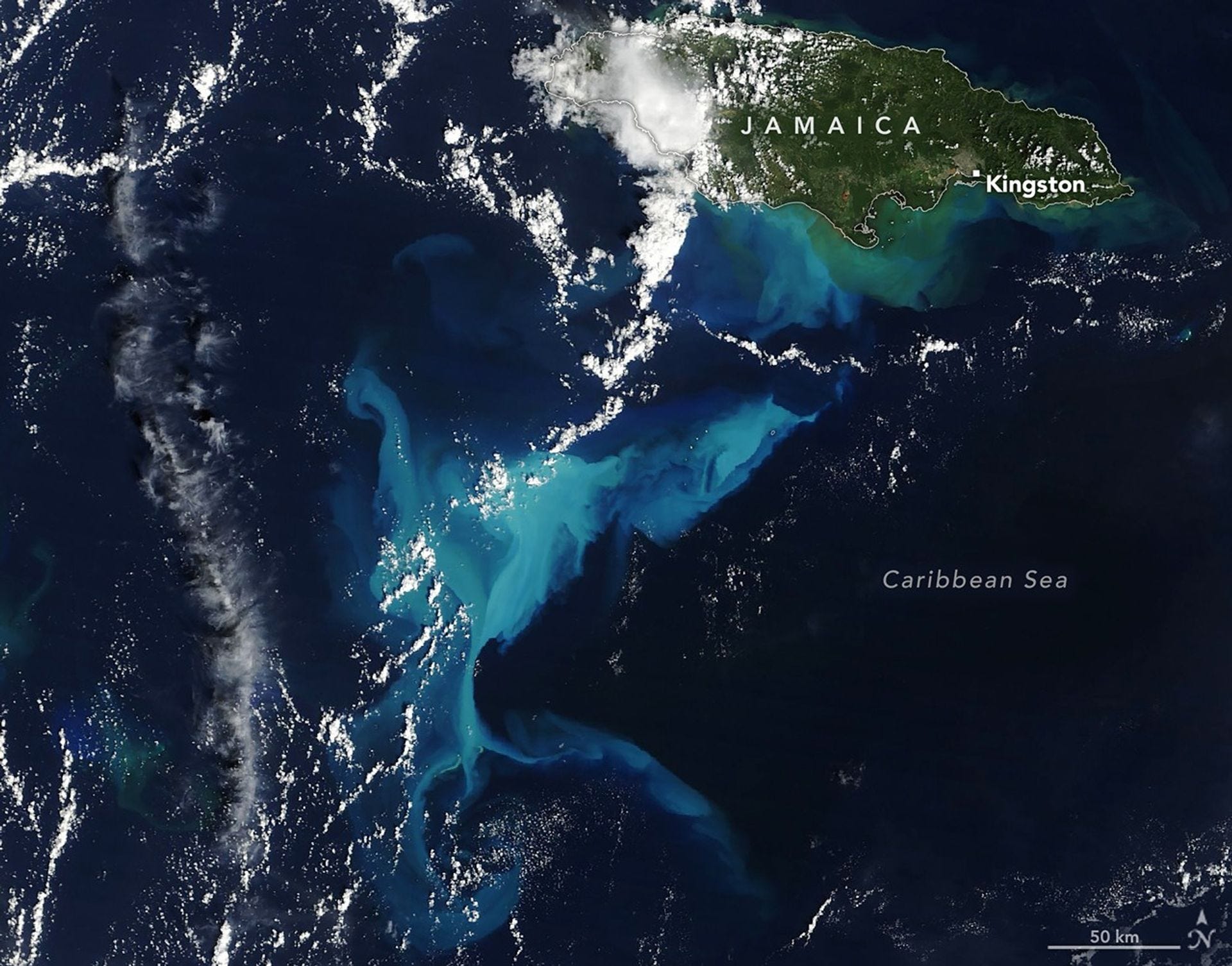
A Plume of Bright Blue in Melissa’s Wake [link]
Hurricane Melissa resuspended carbonate sediments from Pedro Bank south of Jamaica, producing what scientists believe is the largest such event observed in the satellite record. MODIS imagery captured bright blue waters caused by suspended calcium carbonate mud stirred up by the Category 5 storm, revealing surface currents and sediment transport patterns across an area more than three times the size of Jamaica. While the visual signal faded within days, researchers note potential longer-term impacts on benthic ecosystems and emphasize the role of such events in transferring carbon from shallow marine sediments to the deep ocean.
Interesting read
Towards mutualism: reconciling differences between field and EO data [link]
In this thoughtful essay, Planet scientist Chris Anderson argues that field data and Earth observation should be treated as complementary, not competing, ways of understanding nature. He makes the case that satellite data is a fundamentally different measurement system, best evaluated through uncertainty-aware aggregation and fusion with field plots, rather than pixel-level comparison. The post outlines a path toward a “mutualistic” future where field campaigns and satellites reinforce each other, improving both ecological science and large-scale decision-making.
New interactive map shows how flammable your part of Australia is right now [link]
Geoscience Australia has launched a new interactive map that shows how dry and flammable vegetation is across Australia in near real time, using high-resolution satellite data from Sentinel-2 and machine-learning models.
The tool turns satellite light measurements into 20-metre maps of fuel moisture, helping fire agencies, Indigenous fire practitioners, insurers, and planners see where landscapes are ready to burn and where they are not, enabling earlier and more targeted fire prevention.
Explore the interactive map here.
Quantifying local climate regulation in three Estonian cities [link]
Estonia used Copernicus tree cover, evapotranspiration, and land surface temperature data to map how much urban vegetation cools three cities, Tallinn, Tartu, and Narva, producing 30 m maps of local climate regulation.
The study shows that forests, parks, and green spaces create measurable cooling zones across cities and provides a first quantitative basis for including urban nature in national ecosystem service accounting and urban planning.
Regional assessment of above-ground biomass using field, airborne light detection and ranging and satellite data integration [link]
FAO published a methodological study on estimating above-ground biomass in West Africa by integrating field plots, UAV LiDAR, and NASA’s GEDI satellite data.
The work focuses on producing consistent regional biomass estimates in areas with limited forest inventory data.

Tiny patches of deforestation drive tropical carbon loss [link]
A new study published in Nature shows that small, incremental forest clearings, often under two hectares, drive more than half of net tropical carbon losses despite accounting for only a small fraction of disturbed area. Using high resolution satellite biomass data, the research shows how cumulative human activities, rather than large scale deforestation alone, are reshaping the tropical carbon balance.
Japan’s FOSS4G Community: An Introduction to OSGeo Japan & OpenStreetMap Japan [link]
With FOSS4G 2026 heading to Hiroshima, this article offers a timely look at how Japan’s open geospatial ecosystem took shape. It traces the growth of OSGeo Japan and OpenStreetMap Japan, showing how regionally rooted FOSS4G activities, citizen mapping, and open data have combined into a resilient, nationally connected community.
LinkedIn Highlights
Rethinking Early-Career Engineering in an AI-Native World [link]
A sharp reflection from Shay Strong, VP of Analytics at ICEYE, on what it actually means to hire and grow engineers in an AI-native world. Less talk about productivity gains, more focus on judgment, ownership, and how AI can genuinely compress the “junior” phase when we rethink hiring and mentoring.
Upcoming Events
Short Course - Using EUMETView and Jupyter Notebooks to depict a Dust Event [link]
On 10 February 2026, EUMETSAT will host a short online course demonstrating how to detect and analyse dust events using EUMETView and Jupyter Notebooks. The session walks through a complete workflow, from visual identification of dust plumes to interactive analysis of Sentinel-3 SLSTR AOD and Copernicus Climate Change Service IASI-based dust optical depth products.
RGS-IBG AIC 2026 • Geospatial Artificial intelligence methods and applications [link]
The RGS-IBG GIScience Research Group has opened a call for abstracts for a 2026 conference session on Geospatial Artificial Intelligence methods and applications, focusing on advances in GeoAI theory, methods, and real-world use. The session invites work spanning foundation models, uncertainty, causality, ethics, and reproducibility in GIScience and quantitative geography, with abstracts due 23 February 2026.
GeoAI 2026 Submission Deadline Extended to 3 February 2026 [link]
The submission deadline for GeoAI 2026 has been extended to 3 February 2026 for extended abstracts and the published-article track, following strong community interest.
Understanding Climate Data: From analysis of the past to future projections [link]
Copernicus Climate Change Service is launching an eight-hour, self-paced online course in February 2026 that teaches professionals how to understand and use climate data in their work.
The course introduces observations, reanalysis, seasonal forecasts, and climate projections, and shows how to access and interpret these datasets through the C3S Climate Data Store so users across sectors like energy, finance, planning, and policy can apply climate information with confidence.
Call for expressions of interest: Earth observation case studies for the 2026 CEOS Earth Observation Handbook on Adaptation and Resilience [link]
The call targets practical examples where satellite EO supports climate adaptation, risk reduction, and National Adaptation Plan processes across sectors such as water, agriculture, health, ecosystems, and infrastructure.
Expressions of interest close on 31 January 2026, with publication planned ahead of COP31.
Learning

TerraBytes Processings Now Available in Proceedings of Machine Learning Research (PMLR) [link]
"Earth Observation presents unique challenges for machine learning due to its non-stationary data distribution, spatio-temporal biases, and multimodal nature. TerraBytes aims to address these challenges by fostering discussions at the intersection of data curation, machine learning, and remote sensing. The workshop focuses on (1) curating less biased, globally representative EO datasets, (2) developing adaptable ML models for EO applications, and (3) bridging the gap between data acquisition and ML communities. By promoting interdisciplinary collaboration, TerraBytes seeks to advance EO research and enable inclusive, fair, and impactful applications."
Watch the workshop online here.
Presentations From VH-RODA 2025 Now Available [link]
All talks from the November 2025 workshop in Frascati have been published, covering calibration and validation across optical, thermal, SAR, atmospheric composition, and related domains.